
News
And It’s a Wrap!
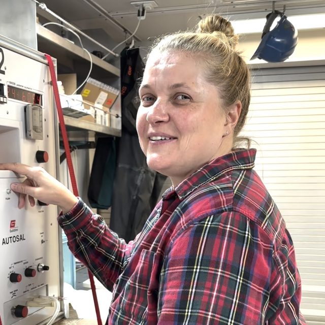
The Coastal Pioneer Array MAB team completed all the objectives of Leg 1 by the end of the day April 8th and started the transit home, back to the dock at Woods Hole. Taking advantage of a day in the wet lab, Glider Lead Diana Wickman took the opportunity to interview some folks about their experiences aboard the Armstrong over the last nine days. Hear what they have to say about the best parts of the journey.
Read MoreHoses Galore Hold Moorings Together
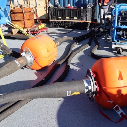
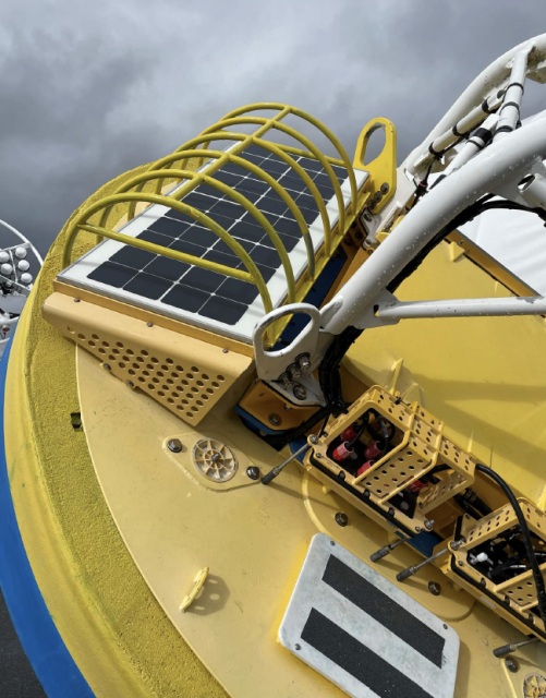
A flexible connection between the buoy and the anchor of the Coastal Surface Moorings of the Pioneer MAB Array is created by multiple hoses with the capacity to stretch while maintaining an electrical connection (Fig 1). The stretch is necessary to account for wind, waves and currents that push and pull the buoy relative to the anchor. The hoses connect mooring components and contain coiled conductors that allow data transfer and carry power generated by wind turbines and solar panels on the buoy.
The Northern Coastal Surface Mooring deployed for the first time in the MAB on April 4, 2024, illustrates the vital role these connection points play in keeping the mooring in place and operating. The mooring was deployed in 100 meters of water. The surface buoy is connected to the near surface instrument frame with a five-meter-long electromechanical chain (EM) chain. The EM Chain is flexible enough to bend to allow deployment (Fig. 2) but does not stretch. This provides support and stability at the top of the mooring. The EM chain also contains conductors to allow transmission of power created by solar, wind, and batteries on the surface mooring to the instruments below.
[media-caption path="https://oceanobservatories.org/wp-content/uploads/2024/04/EMChain.jpg" link="#"]Fig 2. The EM Chain connects the bottom of the surface buoy to the Near Surface Instrument Frame (NSIF) to left. Credit: DT Crist © WHOI.[/media-caption]Power moves through the EM chain to the instruments attached to the Near Surface Instrument Frame (NSIF), and then off to three stretch hoses each 30.48 meters long! The stretch hoses do what their name implies, stretch as needed in response to environmental conditions, yet they are strong enough to keep the mooring in place. The first section of stretch hose is connected to a Hose Interface Buoyancy (HIB) module, an orange flotation device that helps keep the stretch hoses floating and upright. The second section of stretch hose connects to a second HIB. Electrical connectivity is maintained by wired connections from the end of a stretch hose, through the hollow center of the HIB, and then to the next hose.
[media-caption path="https://oceanobservatories.org/wp-content/uploads/2024/04/HIBS.jpg" link="#"]Two Hose Interface Buoyancy (HIBs) sections are connected to each other with electromechanical stretch houses that provide flexibility and strength to the mooring and transmit power down the line. Credit: DT Crist © WHOI.[/media-caption]The third stretch hose section is connected to the Multi-Function Node (MFN), which houses instruments that need power. The MFN also contains the anchor.
[media-caption path="https://oceanobservatories.org/wp-content/uploads/2024/04/MFN.png" link="#"]The Multi-Function Node and Anchor Assembly being deployed off the back deck of the R/V Neil Armstrong. The stretch hose, which connects it to the rest of the mooring, is at the top and to the right. Credit: DT Crist © WHOI.[/media-caption]
[media-caption path="https://oceanobservatories.org/wp-content/uploads/2024/04/Complete-configuration.jpg" link="#"]More than 96 meters of hose keep the Coastal Pioneer Northern Array in place in its new location in the Mid-Atlantic Bight. Credit: DT Crist © WHOI.[/media-caption]
Perspective in Pounds
What’s amazing about the hoses that keep the Pioneer moorings on station and operational is the scale of the equipment that makes up the mooring. Take the top and the bottom of the mooring, for example. The Surface Buoy weighs some 8,500 pounds. The MFN and Anchor Assembly weigh 11,000 pounds. These weights and the scale of the equipment are not only challenging for moving around the deck and getting into the water, but thanks to the hoses these massive components are able to stay in the water, collect data, and report for up to six months. Hats off to hoses galore!
Read More
A Post Doc Project with Ten Years of Ready-made Data
Katie Bigham has been around OOI for nearly a decade. Her involvement began in 2014 when she was an undergraduate at the University of Washington (UW) and took part in the marathon 83-day OOI Regional Cabled Array’s (RCA) final construction cruise that installed over 100 instruments, 9 moorings, 18 junction boxes and thousands of meters of extension cables. At the time, she was onboard as part of UW’s VISIONS program, an at-sea education program designed for students to experience all aspects of seagoing research and life aboard a global class oceanographic research vessel hosting a remotely operated vehicle (ROV). With a taste of Axial Seamount and hydrothermal vents on the ocean floor provided by her first sea-going experience, Katie landed on a direct career path to where she is today — a benthic ecologist post-doc at UW, using OOI data. It’s a repeat pattern for Katie. She first used RCA OOI data to write her senior thesis focused on life thriving at Southern Hydrate Ridge methane seeps before graduating with a degree in Oceanography from UW in 2017.
[media-caption path="https://oceanobservatories.org/wp-content/uploads/2024/04/2Katie_Studenst_sm-20230908_200403_startL4_ME-copy-scaled-1.jpg" link="#"]Chief Scientist Katie Bigham (back row, second from left) and VISIONS’23 students on the R/V Thompson during Leg 4 of the OOI-RCA operations and maintenance cruise. Credit: M.Elend, University of Washington. [/media-caption]After graduation, Katie took a couple of gap years, where she worked as a research associate for the OOI RCA and continued to go out on RCA’s annual recovery and deployment expeditions. She then decided to go for a PhD, relocating to Victoria University of Wellington in New Zealand during the height of COVID. While other colleagues’ research was stymied by the effects of the worldwide lockdown, Katie, luckily, had access to years of data on benthic communities in Kaikōura Canyon, a highly productive submarine canyon. As a benthic ecologist, she is interested in how and why biological communities change over time. Her dissertation focused on the impact of the magnitude 7.8 Kaikōura Earthquake in 2016 on the benthic community and it’s recovery. To assess this, she used co-registered detailed bathymetric and multicore data, as well as repeat photographic surveys from both before and after the disturbance.
“For a lot of these deep communities, we don’t really know what the baseline is for them. We don’t know what normal is,” Katie said. “I’m really interested in how to get the most out of multiscale, complex data sets to answer these important questions. Ship time is expensive. It’s hard to work in the deep sea and conditions there are really tough on instruments and equipment. That’s why projects like OOI are a great way to provide critical data over the long haul.”
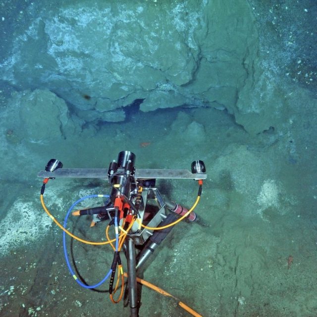
During her PhD, Katie applied for and was awarded a National Science Foundation Postdoctoral Research Fellowship within the Ocean Sciences Division. “Funny, but my original thought was to try to Pandemic-proof my post-doc. I wanted to formulate a project that would advance our knowledge of benthic communities thriving in dynamic environments and be achievable in a 2-year time period. I was looking for something that would be cohesive and with readily available data that wouldn’t be at risk from COVID impacts, such as requiring laboratory studies. After considering available datasets, from my senior thesis work, I remembered the tens of thousands of images and terabytes of video collected at Southern Hydrate Ridge (SHR) since 2008 during the early days of the RCA and follow-on annual cruises, as well as the now nearly decade of data provided by the cabled instrumentation. Using these data, I was able to immediately start asking questions about long term temporal changes in biological communities associated with methane seeps. The wealth of high quality imagery collected at SHR, is nearly unparalleled for these environments.”
Katie is using imagery from the SHR digital still camera and ROV imagery for her research project. The cabled camera located at the Einsteins’ Grotto methane seep turns on its lights every half hour, takes three pictures, and then turns off. “It’s a highly dynamic environment where we’ve seen significant changes since the camera and the other equipment was first put in place there. This site hosts ‘vagrants’ or non-endemic megafauna, along with chemosynthetic bacteria that form extensive mats and clams with symbiotic bacteria. But, we also see rockfish, flounders, hagfish, eelpouts, and other visitors that come into the area, as well as soft corals and Neptunea nurseries because we think the seep is acting as a kind of an oasis for these organisms.”
[media-caption path="https://oceanobservatories.org/wp-content/uploads/2024/04/For-Katies-piece-good.camdsr1767_02826.sm_-scaled-2.jpg" link="#"]The SHR digital camera located at the Einsteins Grotto methane seep provides Katies with imagery for her research. Credit: OOI/UW/CSSF; Dive R1767; V14. [/media-caption]The visual imagery available is helping Katie better understand cold seeps and how and why they are attracting other species. “Better understanding of methane seeps is important because of the potential interest in mining them, and because places like SHR are deemed “essential fish habitats.” Hence, we need to understand their relevance to fish stocks, including that perhaps they may be serving as nursery areas. Over 1,000 sites along the Cascade Margin are known to venting methane, but less than ~five have been studied in any detail.”
The imagery allows researchers like Katie to begin to look at the temporal dynamics of these communities and determine whether they respond to particular cycles, such as tides, changes in the chemosynthetic concentrations, or pulses of macroalgae from the surface, as well as the long term impacts of ocean warming. “The images are helping us understand the colonization of specific organism types and how benthic communities are using these sites over time. Because the datasets are so high-resolution with data every half hour, we can look at larger annual cycles and changes from season to season and year to year,” Katie added. Other SHR co-located cabled instrumentation also allows for investigation of changing conditions due to seismic events, for example.
The Challenges of Big Data
Katie’s task over the next two years is not an easy one. The digital still camera alone produces over 50,000 images a year. These data, coupled with terabytes of 4K and HD imagery, as well as thousands of images taken during ROV dives in the area, creates a huge amount of imagery to process. She’s tackling this effort in two stages: The first is to bring in machine learning and computer vision techniques to aggregate the datasets. Once that is accomplished, there’s the bigger task of looking at the imagery and classification output to determine what can be learned about the inhabitants of the seep area.
The first task to incorporate AI into helping sort the imagery is to label various features. “Obviously, the holy grail would be, the computer just does it for you. But because this still camera is looking at generally the same scene all the time, it’s ripe for putting an event detector or machine assisted annotation, where the computer can help differentiate today’s picture from yesterday’s picture,” she added. With such computerized assistance, researchers like Katie can then spend their time looking at the animals and observing their behavior rather than having to annotate each image. She gave an example: sometimes a crab will find a home on the camera and hang out there, blocking images of the area. A computer “trained to identify when this happens,” could allow researchers to avoid this occurrence when they can’t see behind the crab.
“I’m super stoked about this project. It’s been an exciting thing to be working on and it’s been really cool to bring together my scientific background and access to RCA-OOI data,” Katie said. “I’m developing automated digital analyses techniques that when I worked on my undergraduate thesis thought it’d be so cool to do and I’m doing it now.”
With a powerful computer and multiple monitors in hand, in two years when her post doc ends (December 2025), Katie will have moved the world of AI forward to analyze an unprecedented amount of data within this marine ecosystem, resulting in one or more scientific papers about the temporal dynamics of benthic communities and how and why they change over time–in her words “a nice, cohesive, achievable effort!”
Read More
A Remarkable Underwater Robot
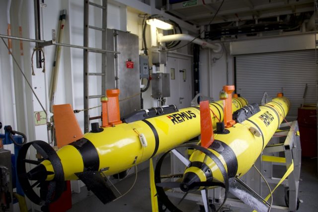
Two REMUS 600 autonomous underwater vehicles (AUVs) are components of the Coastal Pioneer Array at its new location in the Mid-Atlantic Bight (MAB). Their mission is to collect data through the water column and in between moorings, serving as an additional data source and validating data collected at the stationary moorings.
The two AUVs at the Mid-Atlantic site will be collecting data at the site 4-6 times/year. They will travel across the shelf and along the shelf on a prescribed route within the footprint of the moored array.
[media-caption path="https://oceanobservatories.org/wp-content/uploads/2024/04/MAB_VIP_AUV.jpg" link="#"]The AUV sampling route at the Coastal Pioneer Array in the MId-Atlantic Bight.[/media-caption]Prior to being loaded onto the R/V Neil Armstrong for the initial deployment at the MAB site, the OOI Coastal and Global Scale Nodes (CGSN) vehicle team at Woods Hole Oceanographic Institution (WHOI) put them through a rigorous series of checks to make certain they will operate without incident in this new location.
“We run the vehicle through a whole bunch of lab and bench tests, so we are confident that all major systems are working, and it is capable of executing a pre-programmed route when in the water,” explained CGSN Vehicle Lead Diana Wickman.
Once the AUVs passed inspection, they were loaded on the R/V Neil Armstrong to make their way to the MAB. The onboard vehicle team of Wickman and Andy Robinson still had tasks to accomplish before setting them on their journey.
The team mapped a detailed route with waypoints related to the configuration of the Pioneer Array in this new location. These AUVs will survey the array at three knots (as opposed to gliders, which travel at 0.3 knots). This faster AUV speed through the water makes it possible to capture dynamic flows and currents, which is especially important in the more complex area of the MAB. Once programmed, the vehicle team maintains control of the AUV from the ship via a Vehicle Interface Program (VIP)—a specialized program designed to communicate with the deployed AUV. The VIP gives the AUV team the ability to monitor health and performance of the vehicle and change parameters or alter the mission, when and if needed.
An ability to track the AUVs while they are underway is especially important for the way they are used at the Pioneer Array. “Our vehicles’ configuration makes it possible to cover more ground and complete longer surveys than more traditional AUVs could achieve,” said Robinson, CGSN Vehicle Technician. They were designed with efficiency in mind, carrying a streamlined sensor payload rather than the power-hungry sonar or mapping equipment that many REMUS AUVs operate. This allows the vehicles to stay deployed for at least 24 hours, each set to cover 110 km (68 mi) in a typical mission at the MAB.
[media-caption path="https://oceanobservatories.org/wp-content/uploads/2024/04/IMG_1378-copy.jpg" link="#"]These two AUVs will “fly” through water at the new location of the Coastal Pioneer Array in the MId-Atlantic Bight on April 6, 2024. Credit:DT Crist © WHOI.[/media-caption]AUVs are equipped with the same sensors as the four gliders that will be deployed in this new array location. The AUVs will supplement and validate the data being collected by the gliders as well as the moorings. In contrast to the AUVs’ intermittent surveys, gliders will stay onsite and capture data for the six months the array will be in the water. The AUVs’ data collection trips serve to validate the data collected by the gliders as well as providing additional data to promote understanding of conditions in the region.
The AUVs will make their first reports from the MAB this Saturday, April 6, 2024.
Read More
Historic, Continuing Collaboration
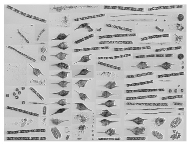
The U.S. National Science Foundation Ocean Observatories Initiative (NSF-OOI) and the Northeast U.S. Shelf (NES) Long-Term Ecological Research (LTER) project have been collaborating since 2017, when the original OOI Coastal Pioneer Array was deployed 75 nautical miles off the coast of Martha’s Vineyard. Representatives from the NES-LTER project would join the Pioneer Deployment and Recovery expeditions in this region for their spring and fall seasonal cruise. Their work includes deploying an Imaging FlowCytobot (IFCB) to sample continuously from the ship’s underway science seawater while OOI cruises were underway.
An IFCB is an in-situ automated submersible flow cytometer that generates images of particles taken from the aquatic environment. Designed and built by researchers at Woods Hole Oceanographic Institution (WHOI), the IFCB has since become commercially available through McLane Research Laboratories.
“IFCB enables us to study the phytoplankton and microzooplankton inhabitants of a given region. We can see what plankton are present over time and how the community structure adjusts to changes in the ecosystem,” explained Taylor Crockford, a WHOI researcher who regularly deploys IFCBs. “NES-LTER conducts four seasonal cross-shelf surveys per year studying the food web and physical properties of the surface waters and water column from near shore to the shelf-slope break, which includes the location of the original Pioneer Array. Now that the Pioneer Array is moving south, we are excited to have the opportunity to continue this collaboration and build upon our understanding of the planktonic communities in the region.”
[media-caption path="https://oceanobservatories.org/wp-content/uploads/2024/04/Cytobot-image.png" link="#"]A glimpse at the diverse plankton community IFCB is currently seeing today (April 2, 2024) during the transit south to the new MAB Pioneer location. Credit: Taylor Crockford © WHOI. [/media-caption]During the initial deployment of the Coastal Pioneer Array at the Mid-Atlantic Bight (MAB), this collaboration continues. Crockford is aboard the R/V Neil Armstrong and using an IFCB to collect data as part of the project’s broadscale study region (ongoing since 2013) while the ship transits to and from the new deployment site off the coast of Cape Hatteras, NC.
When the ship and team arrive at Pioneer’s new location, she will be lending her expertise to the deployment team for it is the first time a Plankton Imaging System (PLIMS) is being deployed on one of Pioneer’s Central Surface Moorings. This new deployment is an outcome of community input during an NSF and Ocean Observatories Initiative Facility Board sponsored workshop in 2021.
Read More
OOI Data Center Progress Report
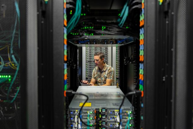
Craig Risien, project manager for the U.S. National Science Foundation Ocean Observatories Initiative (OOI) Data Center, likens the role of the OOI Data Center to that of Gmail or Google Drive. “When people log into Gmail, it just works. They don’t think about servers, networking, backing up and whatever else behind the scenes is required to allow you to just log into your Google environment and send emails, create documents, or move or download files. Typically, people don’t think about that back-end infrastructure. That’s the type of user experience we are looking to achieve when we create data services such as the OOI JupyterHub”. After two years at the helm of helping plan and build the new OOI 2.5 Data Center at the Oregon State University, Risien says the Center is functioning well and users are starting to take advantage of OOI provided infrastructure such as the OOI JupyterHub for research and teaching.
Oregon State University (OSU) was awarded the contract to run OOI’s Data Center starting in October 2020. In three and a half years, the Data Center team built two data centers. To accomplish this, they migrated two data centers, the original OOI Data Center at Rutgers University to OSU, and then the OOI 2.0 Data Center to the new OOI 2.5 Data Center. The data team at OSU accomplished all of this with virtually no downtime for both data center migrations.
“We’ve had less than 90 minutes of total downtime, when we transferred data to the current servers at OSU,” explained Risien. “And the majority of that downtime wasn’t because of hardware issues or moving data, we actually took the opportunity presented with these kinds of migrations to improve the system and make it work better for the next five years.”
The system downtime was associated with hardware migrations, when the team had to switch over old firewalls to new firewalls. This switch required physically unplugging fiber cables from off old firewalls and shifting them over the new ones. This switch was made early in the morning so there was no significant impact on the system availability. Risien laughed and said, “I think the total downtime there was about 20 minutes.”
[media-caption path="https://oceanobservatories.org/wp-content/uploads/2024/03/Risien-OOI_mi_010.jpeg" link="#"]Craig Risien, project manager of the OOI Data Center, working on computer infrastructure at the Data Center, located at the Oregon State University in Corvallis, Oregon. Credit: Maia Insinga, OSU.[/media-caption]The team used the limited downtime when data were being migrated to a new storage cluster to disaggregate development software environments and to change the network design.
“We seized on the transfer to a new storage cluster to put network segmentation in place, in other words we segment our network into different streams for different applications,” added Risien. “This improves our security posture because it makes it harder for somebody to move laterally through the system. It also allows for optimizing network performance and provides us with greater control over network traffic.”
Cybersecurity improvements
These successful data migrations are only the tip of the iceberg of what OSU’s data team has achieved over these past few years. Working with Dell, which provides the cyberinfrastructure hardware, the team shifted from a tape to disc-based backup solution. In addition to an existing tape backup library at the Texas Advanced Computer Center, OOI’s data are now routinely backed up to a geographically remote storage cluster in Bend, Oregon. “Backing up OOI data on disk in Bend is important because we now have an immutable copy of OOI data in a remote location. This means we could recover from a disaster much faster than with data stored on tape. Disc recovery would take days to weeks, as opposed to possibly many months from data stored on tape.”
Other cybersecurity improvements have been made over the last few years. The Data Center now has a storage solution – a Dell Data Domain – that provides an “air-gapped” backup of virtual machines that do the system monitoring, computation, and data delivery to end users.
During the third week of March 2024, a copy of all raw data and virtual machine backups to the storage cluster in Bend was completed. The transfer of 1.8 PB of data took about 10 days to complete with transfer rates at times exceeding 60 Gb/s, which is about 20 times faster than the transfer speeds a person will typically see when copying data to an external solid state hard drive.
“Obviously scientific data are critical in a recovery situation, but so are the virtual machines that process the data,” added Risien. “This air gapped backup of our virtual machines would allow us to recover far faster in a disaster recovery situation. We take security, backing up of data and our virtual machines very seriously. About third of our budget was spent on the systems that create these air gapped immutable backups of our data and virtual machines to make sure OOI data are secure and retrievable, if needed.”
A massive data transfer
Risien attributed the success of seamlessly transferring vast amounts of data and hundreds of virtual machines to the improved network speeds and technologies involved. One example he gave was the compute cluster, which consists of 16 VxRail appliances that run the virtual machines. “Using VMware VMotion we were able to move hundreds of running virtual machines from our OOI 2.0 VxRail clusters to the OOI 2.5 cluster, with no downtime or service disruptions, unbeknownst to our program partners or external users, which I find remarkable.”
What else is remarkable is that this data transfer and security improvements were accomplished in a seamless way by a very small team. In addition to Risien, Anthony Koppers serves as Cyberinfrastructure Principal Investigator (PI), Jim Housell as the IT Architect, Casey Dinsmore as the DevOps Engineer, and Pei Kupperman, as the Finance Lead. “Our small team was able to move this massive amount of data, securely without downtime, in part because of a really productive partnership with Dell, which brought a complete solution to the table. And we’ve worked with other great partners at the Cascade Divide Data Center, and the OSU networking team, without whom we wouldn’t have been able to make the connection out to Bend. Good partnerships, and great people coming together was what made this all happen.”
.
Read More
First Deployment of the Pioneer Array in the MAB
At 0900 Eastern on Monday April 1, 2024, the R/V Neil Armstrong will back out of the dock at Woods Hole, MA to begin the transit to the new location of the U.S. National Science Foundation (NSF) Ocean Observatories Initiative (OOI) Coastal Pioneer in the Mid-Atlantic Bight (MAB). This promises to be a momentous trip for it will be the first deployment of the Pioneer in the MAB, a location decided upon after a series of NSF-sponsored meetings with community users of OOI data. The expedition also will mark the 20th Pioneer deployment undertaken by the Coastal and Global Scale Nodes (CGSN) team at Woods Hole Oceanographic Institution (WHOI).
“The array is design to provide data to help scientists better understand the dynamics of the region, the role of biogeochemical cycling and transport, and the impact of extreme events like hurricanes and freshwater outflows,” said Albert Plueddemann, chief scientist for this first deployment and lead scientist of the CGSN group. “There’s already considerable community interest in obtaining data from the OOI infrastructure and leveraging the array installation for research and testing. Once the array is in place, we anticipate even more interest, and look forward to engaging with researchers in the region.”
The Pioneer MAB is a T-shaped array with moorings, located offshore of Nags Head, North Carolina, at depths of 30-300 meters and nominal spacing of15-25 kilometers. The array will consist of ten platforms at seven different sites – two platforms will be deployed as adjacent pairs at three sites. The platforms include three surface moorings, five profiler moorings, and two shallow-water moorings. The Pioneer MAB will also have mobile assets—four coastal gliders and two autonomous underwater vehicles (AUVs). These mobile assets will traverse the water column along different track lines to give a fuller, more robust picture of water column properties.
[media-caption path="https://oceanobservatories.org/wp-content/uploads/2024/03/MAB-Array-map-3-scaled.jpg" link="#"]Figure 1: Location of moorings of the Coastal Pioneer Array in its new location in the Mid-Atlantic Bight.[/media-caption]After a ~36-hour transit to the site, the team of 15 scientists and engineers will get to work to deploy the new array. Because of the large size of the moorings, the expedition will be conducted in two legs and be completed on April 22nd. In addition to the mooring and mobile asset deployments, the team will be conducting CTD (to measure conductivity, temperature, and depth) casts with water sampling at the deployment sites. In addition, they will be making ship vs meteorological comparisons at the surface mooring sites to ensure the rigor and accuracy of meteorological measurements. They also will be conducting some shipboard underway surveys, as well as a bathymetric survey to gain a complete picture of the new location.
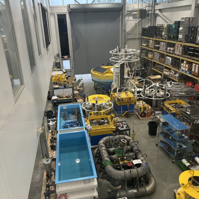
[media-caption path="https://oceanobservatories.org/wp-content/uploads/2024/03/IMG_0550-2-scaled.jpg" link="#"]A lot of equipment is at the ready! Northern and Southern Coastal Surface Moorings, along with seabed multi-function nodes and near-surface instrument frames, as they were being assembled. The team integrates the science instrumentation with the mechanical/power/telemetry/data systems, then tests the system before loading on the vessel. Credit: Derek Buffitt © WHOI.[/media-caption]Continuing the tradition of the Coastal Pioneer Array off the New England Shelf, this first deployment expedition will be a collaborative one. A marine mammal observer from the National Oceanic and Atmospheric Administration will be onboard to count marine mammals in the region. A representative from the Northeast U.S. Shelf Long-Term Ecological Research (NES-LTER) will be onboard to conduct sampling from CTD casts and flow cytometers, which can analyze the characteristics of cells found in water as the ship is underway. This will be a continuation of an ongoing collaboration for the past seven years. And a Department of Energy representative will also be onboard as tests are conducted to determine the viability of placing a wave energy conversion device on the array.
Along with being the first deployment in the Southern Mid-Atlantic Bight, the Pioneer MAB Array will also include new instrumentation on the three Surface Moorings. The new instrumentation includes plankton imaging sensors (the McLane IFCB), instruments that measure particle size distribution (the Sequoia LISST-200X), short-range velocity profile instruments for the upper water column (the Nortek Aquadopp Profiler-S1VP), turbidity sensors (the Sea-BIrd ECO), and new seafloor pressure sensors (the RBR Quartz3QPlus). These were among the measurements recommended during the National Science Foundation OOI Facility Board community workshops in 2021 to select a new location for the Pioneer Array.
[media-caption path="https://oceanobservatories.org/wp-content/uploads/2024/03/IMG_0554-2-scaled.jpg" link="#"]Sheri White and Nikki Arm prepare and bench test the new Imaging Flow CytoBot, also known as a Plankton Imaging System (PLIMS), that will be deployed on the Central Surface Mooring of the new Pioneer MAB array. The PLIMS generates images of the particles in the local aquatic environment. Credit: Derek Buffitt © WHOI.[/media-caption]
Read More
Call for Applications for OOIFB
[Application Deadline: April 24, 2024]
The U.S. National Science Foundation (NSF) Ocean Observatories Initiative Facility Board (OOIFB) is tasked with representing the science community and users of the NSF Ocean Observatories Initiative (OOI) Facility. The OOIFB works to expand scientific and public awareness of OOI, and ensure that the oceanographic community is kept informed of developments of NSF OOI.
The OOIFB is soliciting applications to fill two membership positions that will open as of June 1, 2024, and run through June 1, 2027. Each selected individual will then be eligible to serve an additional 3-year term. The OOIFB holds at least one in-person meeting per year and one web conference each month.
Scientists, spanning water column to seafloor expertise, as well as experimentalists, engineers, and modelers, with experience using scientific observing systems, such as the OOI, are encouraged to apply. All interested applicants will be considered.
The responsibilities of the OOIFB may include, but are not limited to, the following:
- Serving as the prime scientific and technical conduit between the oceanographic community and NSF regarding OOI.
- Examining the accomplishments and work flow of the NSF OOI Operator, in order to provide feedback regarding the NSF OOI Annual Work Plans (AWPs).
- Via workshops, community meetings, and/or other mechanisms, stimulate and engage the user community in order to keep the accomplishments of the NSF OOI at the cutting edge of scientific inquiry and technological innovation.
- Developing and implementing strategies to expand scientific and public awareness of the unique scientific and technological opportunities of the NSF OOI.
- Helping to identify collaborative relationships with potential governmental, industrial, educational, and international partners in the NSF OOI, where appropriate.
- Ensure fair and consistent access to the NSF OOI by all sectors of the user community.
Applications should be submitted to Holly Morin, at the OOIFB Administrative Support Office (holly@ooifb.org), and must include a letter of interest and a CV. The statement of interest should highlight the applicant’s experience using observatory data, as well as how the applicant has supported the introduction and/or inclusion of ocean sciences to underrepresented communities and have fostered an environment of respect in their research endeavors. Applicants who have not yet had the opportunity for such experience should note how their work will further OOIFB’s commitment to diversity.
Please note, applications cannot be accepted from individuals affiliated with the NSF OOI Program Facility institutions (Woods Hole Oceanographic Institution, Oregon State University, and the University of Washington), individuals under contract with the NSF OOI Program, and individuals from institutions already represented on the OOIFB (the current list of OOIFB members is available HERE).
Applications are due by April 24, 2024. Applications will be reviewed by the OOIFB, who will give due consideration to the qualifications of applicants, as well as the maintenance of gender, career level, discipline, and regional balance on the OOIFB. For more information about OOIFB and its activities, please visit the website, or contact Dax Soule, OOIFB Chair (Dax.Soule@qc.cuny.edu).
Read MoreEndurance Array Reaches 20th Deployment
Since 2014 when the U.S. National Science Foundation Ocean Observatories Initiative Coastal Endurance Array was first deployed in the waters off the coasts of Oregon and Washington, the array has been turned – that is moorings were recovered and replaced with new – 19 times. The upcoming expedition on March 28th, with 15 scientists and engineers aboard the R/V Sikuliaq will be the 19th time that the array has been pulled out of the water and replaced, and the 20th time the array has been deployed.
Over the past nine years, the turns have happened every six months, except for in 2020 when COVID restrictions caused the Endurance team to space two consecutive turn cruises 9 months apart. Regular recovery and deployments are needed to ensure the observing equipment stays operational.
“The EA team has really gotten proficient at turning the arrays,” said Jonathan Fram, the Endurance Array’s Project Manager, who will serve as the Chief Scientist for this expedition, his 10th time leading the effort. “We’ve made many technical improvements over the years to combat the powerful and ever-changing conditions of the Northeast Pacific Ocean so that we can continue to collect and report continuous ocean data from this important region.”
The 20th expedition will begin and end at the Oregon State University’s newly renovated pier in Newport, Oregon. The arrays and associated equipment will be transported to Newport from Corvallis in six tractor trailer trucks. Because of the large size of these components, the expedition will be conducted in two legs. The first leg will head to the Washington site, with a transit time of 2/3’s of a day. The second leg will be to the Oregon site. In total, the team will recover and deploy six surface moorings (two battery powered buoys and four large buoys powered by wind and solar energy), one offshore and three surface piercing profiler moorings, and four gliders. One glider experiencing navigation issues will be recovered. CTD casts (to measure conductivity, temperature, and depth) and water sampling will be conducted along with each mooring operation.
This 20th trip includes several technical improvements. The line used on the Heavy Lift Winch has been increased in size to improve load strength and safety. Each buoy will include a covered wagon style guard against sea lions, who regularly use the buoys as rest stops. All batteries have been replaced or upgraded. Additional improvements have been made that will result in better real-time wind data, and underwater camera operations. The Endurance 20 team also will be deploying new test instruments to see if they might improve data gathering for wind, pH, and partial pressure of carbon dioxide.
[media-caption path="https://oceanobservatories.org/wp-content/uploads/2024/03/Screenshot-2024-03-21-at-11.54.35-AM.png" link="#"]To dissuade sea lions that regularly stop and rest on Endurance Array buoys, OOI engineers have ingeniously devised a steel cover to protect the solar panels that provide power to the mooring. Credit: Jonathan Fram, OSU.[/media-caption]“The order of operations will in part depend on conditions,” added Fram, who joked, “but we expect this trip to be easier than last spring’s, which was three weeks earlier, when we were preparing for the cruise in the snow.”
In addition to regular operations, the Endurance Team will be joined by scientific partners. University of South Carolina (USC) researcher Eric Tappa and Oregon State University (OSU) student Faith Schell will be onboard to help turn a sediment trap adjacent to OOI’s Oregon Slope Base site. This is part of an ongoing research effort of OSU Associate Professor Jennifer Fehrenbacher and USC Professor Claudia Benitez-Nelson, who study the geochemistry, biomineralization, and marine biology of the sediments. Additionally, the team will be deploying fish tag readers for OSU Assistant Professor Taylor Chapple to support his work studying sharks and other large marine predators.
The expedition’s progress will be reported daily. Bookmark this page and follow along as the work unfolds.
Read More
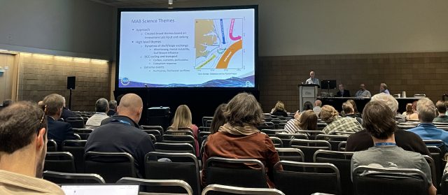
Sharing OOI’s Cyberinfrastructure with NSF COMPASS Fellows
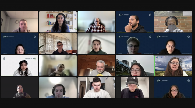
On Thursday March 7, 2024, Senior Manager of Cyberinfrastructure and OOI Data Lead Jeffrey Glatstein introduced a group of 18 students and seven instructors in the National Science Foundation’s CI Compass Fellowship Program (CICF) for Undergraduates to the challenges of collecting, distributing, and keeping safe OOI’s vast amount of data. Students Fellows in CICF learn about real-world cyberinfrastructure challenges, and how to begin solving them for NSF Major Facilities
Glatstein first gave the group an overview of the type, amount, and diversity of data OOI collects from more than 900 instruments. The collected data consists of 135 billion rows of numerical data, 1.2 petabytes of raw data and nearly 10,000 hours of high-definition video, 327,000 hours of audio recordings, and 1.28 million digital still images.
He then shared OOI’s data delivery track record. Since 2016, OOI has responded to 987 million requests for calculated data, providing 333 terabytes of data.
[media-caption path="https://oceanobservatories.org/wp-content/uploads/2024/03/240307_OOI-Jeff-Glatstein_3.png" link="#"]Senior Manager of Cyberinfrastructure and OOI Data Lead Jeffrey Glatstein (green highlighted screen) discussed OOI’s cyberinfrastructure with 18 COMPASS Fellows and their instructors. Credit: CICF.[/media-caption]Glatstein then went into detail about OOI’s extensive cybersecurity measures, which includes multiple storage sites with duplicate data to ensure that if the primary system went down, it could be quickly restored. This is particularly important for OOI because its stores data for posterity for future use in long-term time-series.
The students were amazed and engaged, as demonstrated by multiple questions after the presentation. Said Glatstein, “I enjoy sharing our work with students. It helps open their eyes to career opportunities in unexpected areas, like the ocean sciences, and their questions provides another way into looking at the work that we do.”
Read More