Ocean Observatories Initiative (OOI) Completes Installation of Undersea Cable

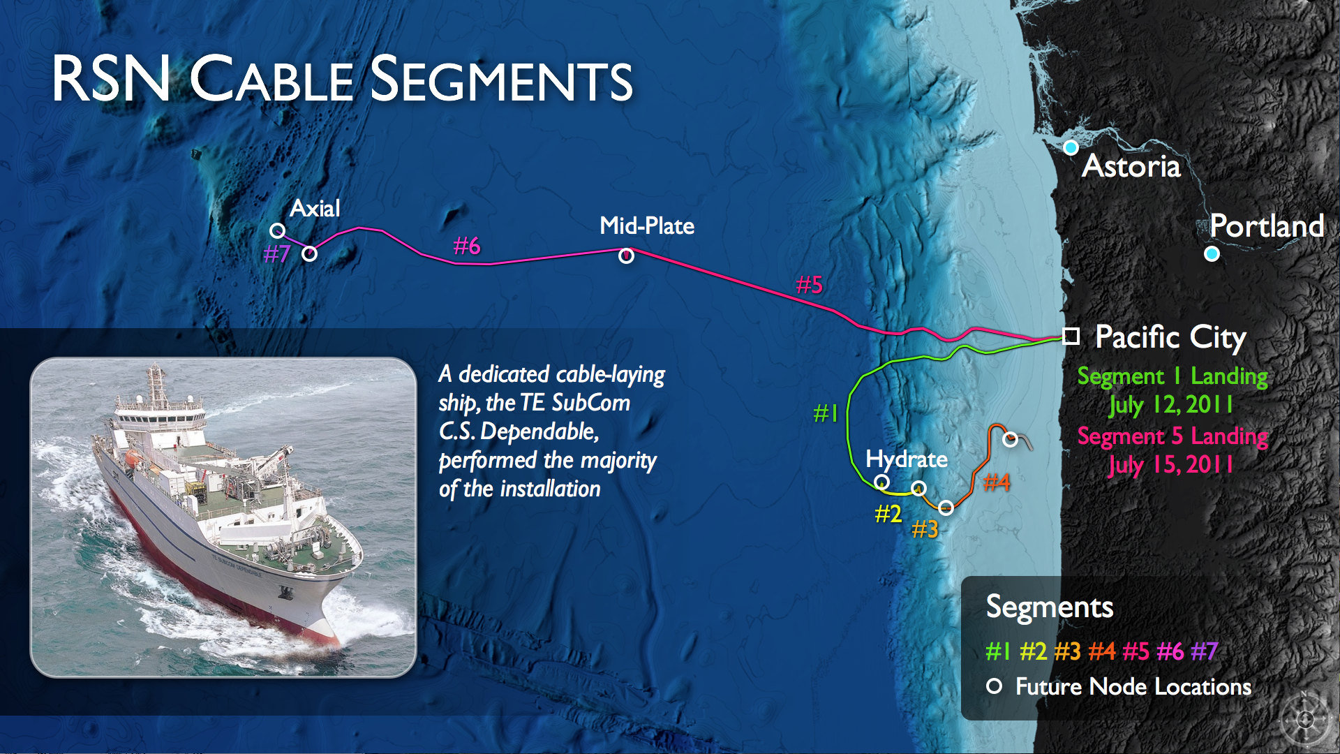
(Click to enlarge) OOI Regional Scale Nodes program and the Center for Environmental Visualization, University of Washington
The Ocean Observatories Initiative (OOI) program in September completed installation of the 540 miles of undersea fiber optic cable that will link scientists and others on land to data streaming from an extensive array of OOI next generation sensors located in the ocean and on the sea floor.
Installation of the 540 miles of the main, or backbone, OOI cable off the coast of Oregon was completed on September 5, 2011.
The OOI team on July 12, 2011, connected the first undersea cable to shore in Pacific City, Ore. That cable links into a shore station there and extends to a study site at Hydrate Ridge, approximately 75 miles off the coast. It then loops back on the continental shelf to link the cable moorings of the OOI’s Coastal Scale Nodes Oregon Line and the Endurance Array site. A second cable, pulled to shore at Pacific City on July 15, 2011, extends 310 miles west to the Axial Seamount study site on the Juan de Fuca Ridge. (These sites can be located on the map right.)
Each primary instrumented site will offer two-way communication between land and sea and will be supplied with up to 10 gigabits per second of telecommunications bandwidth and 8 kilowatts of power. Data will be collected from the sea surface to the seafloor and transmitted to shore in near-real time via the Internet.
The OOI will provide research scientists, educators, students and the public with unparalleled access to the physical, chemical, geological and biological phenomena of the ocean. Sustained ocean observations and interactions that span decades rather than days will allow ocean exploration and discovery to move into previously unimaginable realms. Greater knowledge of the ocean’s interrelated systems is vital for increased understanding their effects on biodiversity, ocean and coastal ecosystems, ecosystem health and climate change.
Of the total 540 miles of the OOI undersea fiber optic cable, 180 miles was buried out to 1 km seaward of the water depth of 700 fathoms. Remotely operated vehicles (ROVs) were used to conduct post-lay inspections and any needed remedial burial. The remaining 360 miles of cable were laid in deep waters without the need of burial.
The TE SubCom Dependable and TE SubCom Sentinel vessels equipped with ROVs carried out the cable laying operations. Cable inspection was conducted during the VISIONS ’11 Research Expedition using the ROV ROPOS deployed from the University of Washington’s R/V Thomas G. Thompson.
The University of Washington is leading the OOI cabled component effort. The cable installation also included individuals from L3 MariPro, the contractor for the design and build of the cabled primary infrastructure; TE Subcom, L3 MariPro’s subcontractor for cable installation; the Oregon Fishermen’s Cable Committee; National Marine Fisheries Service Protected Species Visual Observers program; OOI Regional Scale Nodes Marine Operations; and the Consortium for Ocean Leadership.
The cable installation team was made up of individuals from L3 MariPro; TE Subcom, L3 MariPro’s subcontractor for cable installation; the Oregon Fishermen’s Cable Committee; National Marine Fisheries Service Protected Species Visual Observers program; OOI Regional Scale Nodes Marine Operations; and the Consortium for Ocean Leadership.
The OOI Program is managed and coordinated by the OOI Project Office at the Consortium for Ocean Leadership, in Washington, D.C., and is responsible for construction and initial operations of the OOI network.
In addition to University of Washington, three other Implementing Organizations are responsible for construction and development of the overall program. Woods Hole Oceanographic Institution and its partners, Oregon State University and Scripps Institution of Oceanography, are responsible for the coastal and global moorings and their autonomous vehicles. The University of California, San Diego, is implementing the cyberinfrastructure component. Rutgers, the State University of New Jersey, is responsible for the education and public engagement software infrastructure.
To read more and see photos of that part of Cable Installation click here. The local Pacific City Community also came out to support the OOI at a special OOI Community Event.
For more OOI program news, updates, and photos visit: www.oceanobservatories.org and www.interactiveoceans.washington.edu.
