
Media Inquiries
This section provides a repository of information for journalists and others who wish to quickly find high level information about the Ocean Observatories Initiative. Please contact the WHOI Media Office if you do not find what you need.
Media Inquiries
WHOI Media Office
Woods Hole, MA
E: media@whoi.edu
P: 1-508-289-3340
Project specific queries can be directed to
Amber Coogan Email: amber.coogan@whoi.edu
Images, Logos & Maps
Image Policy
The OOI is a federally (NSF) funded program, as such, all images on our website taken by individuals within the OOI program are considered to be in the public domain, i.e. free for use. The only exception to this is images on the OOI website that were provided by a specific vendor. There are very few of these images on the website and the vendor name will be included in those captions. If you are not sure, feel free to ask! Additionally, if you cannot find the photo you are looking for, please contact the media office and we will help find the image for you. If you do use an image from the OOI website, we just ask that you include either the credit associated with the image on the website or the standard credit: “Image credit: National Science Foundation’s Ocean Observatories Initiative.”
Logos
The following logos are provided in various file formats for use by journalists and members of the public who wish to reproduce the Ocean Observatories Initiative logo. No special permission is required from the Ocean Observatories Initiative to reproduce these images.
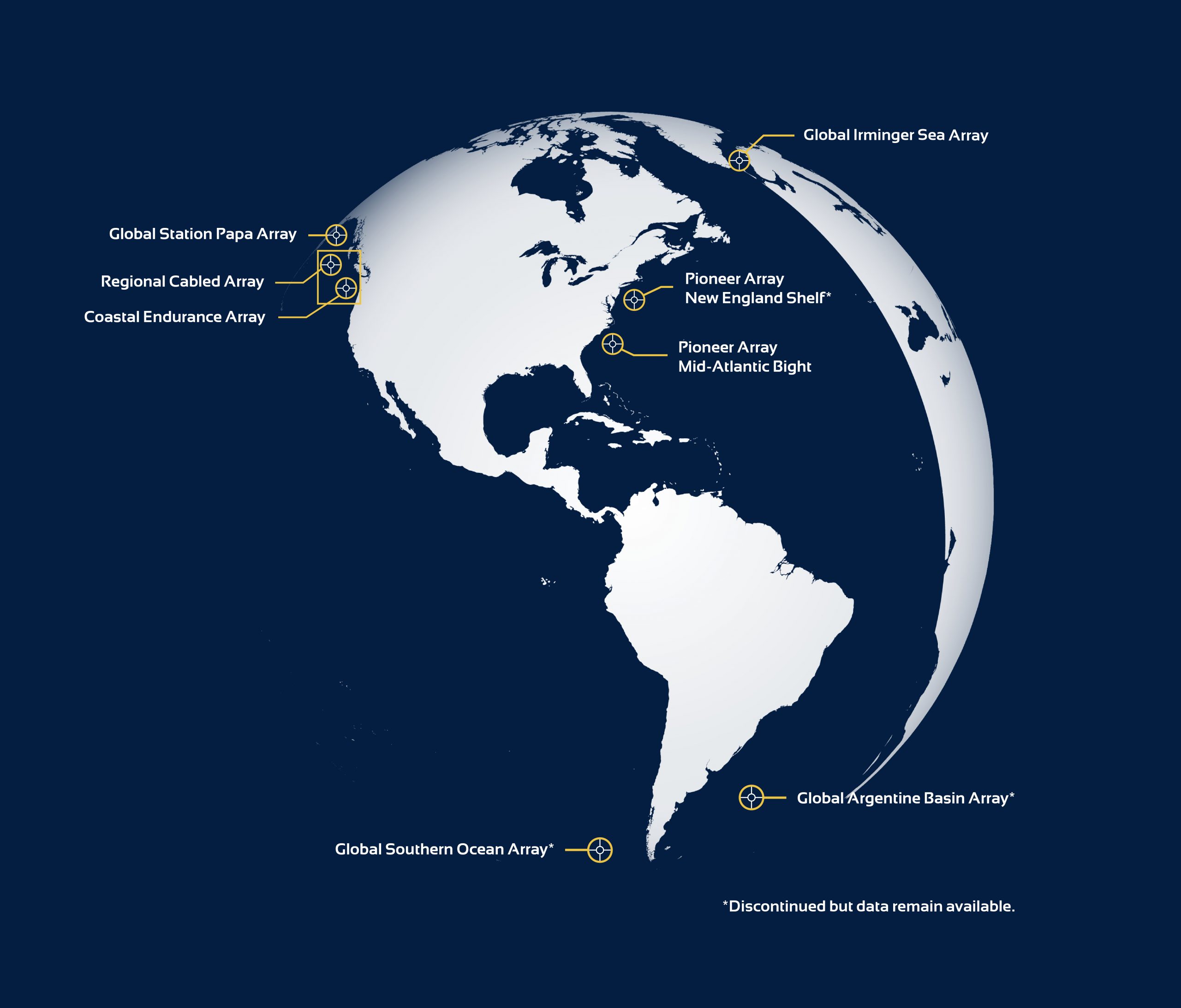
OOI Array Map
Similar to other images, the map of OOI arrays is in the public domain and free for use. The map is periodically updated; the most up to date version can be downloaded here . We ask that when using the map, you please include the following image credit: Image Credit: National Science Foundation’s Ocean Observatories Initiative
Frequently Asked Question
What is the OOI?
The Ocean Observatories Initiative (OOI) is a science-driven ocean observing network that delivers real-time data from more than 900 instruments to address critical science questions regarding the world’s oceans. Funded by the National Science Foundation to encourage scientific investigation, OOI data are freely available online to anyone with an Internet connection.
The OOI network measures the physical, chemical, geological and biological variables of the ocean, seafloor, and near ocean atmosphere. The OOI consists of five arrays located across the Atlantic and Pacific, including one cabled, two coastal, and two global arrays. The OOI infrastructure is made up of 80 platforms, carrying more than 900 instruments, providing over 100,000 data products. Greater knowledge of the ocean’s interrelated systems is vital for increased understanding of their effects on biodiversity, ocean and coastal ecosystems, ecosystem health and climate change. The OOI puts ocean observing data into the hands of a vast user community of oceanographers, scientists and researchers, educators and the public.
How is the OOI Managed?
The OOI is an NSF-funded award to the Woods Hole Oceanographic Institution (WHOI), which leads the OOI Operations and Management (O&M) through sub-awards with Oregon State University and the University of Washington. These institutions function as Implementing Organizations (IOs). The IOs are responsible for operation and maintenance of the different components of the program. WHOI is responsible for the two global arrays (Station Papa and Irminger Sea) and the Coastal Pioneer Array. OSU is responsible for the Coastal Endurance Array. UW is responsible for all cabled assets including those on the Coastal Endurance Array and the Cabled Array. OSU is also responsible for operation of the Cyberinfrastructure component and houses the OOI Data Center.
How is the OOI funded?
The NSF is the sole funding agency for the OOI. The five-year construction phase began in September 2009, with nearly $106 million of first-year funds coming from the American Recovery and Reinvestment Act of 2009. The total construction project budget for OOI was $386.42 million. The FY16-FY18 budget was approximately $55 million per year. The FY19 through FY24 funding is planned at $44M per year. The FY25-FY28 is approximately $56 million per year.
How is the OOI advancing knowledge of the oceans?
The OOI is delivering ocean and atmospheric data and data products 24/7/365 for a 30-year planned life, through an extendable architecture that can meet emerging technical advances in ocean science. The OOI is addressing critical science-driven questions, providing near realtime measurements for scientists, educators and the public, and contributing to a greater understanding and management of our oceans.
Who has access to OOI Data?
OOI data are made available free of charge over the internet to anyone with an Internet connection. This includes a vast user communities of oceanographers, scientists, educators, and the public.
Sign up for the OOI Newsletter here.
To submit a question, go to HelpDesk.