
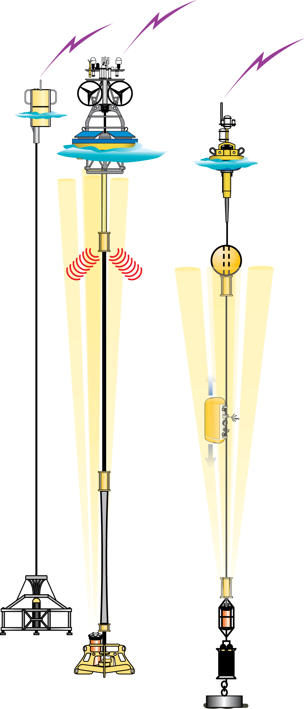
Moorings
The OOI’s oceanographic moorings are anchored to the seafloor by mooring lines from one or more anchors. The mooring lines extend upward from the anchors to buoyant floats located in the water column or at the sea surface. Mooring lines may consist of plastic-jacketed steel wire rope, synthetic line, or electromechanical fiber optic cable with copper conductors.
Moorings provide oceanographers the means to deploy sensors at fixed depths or sensors that can move up and down along the mooring line. These capable and proven oceanographic platforms are used throughout the OOI.
Types of Moorings
Flanking Mooring
Flanking Moorings are subsurface moorings located at the Global Irminger Sea and Station Papa Arrays. Flanking Moorings contain instruments fixed at specific depths along the mooring riser. Subsurface moorings have flotation spheres to keep them in place below the sea surface. As these moorings do not pierce the surface, they communicate and send data to shore via an acoustic link to nearby gliders.
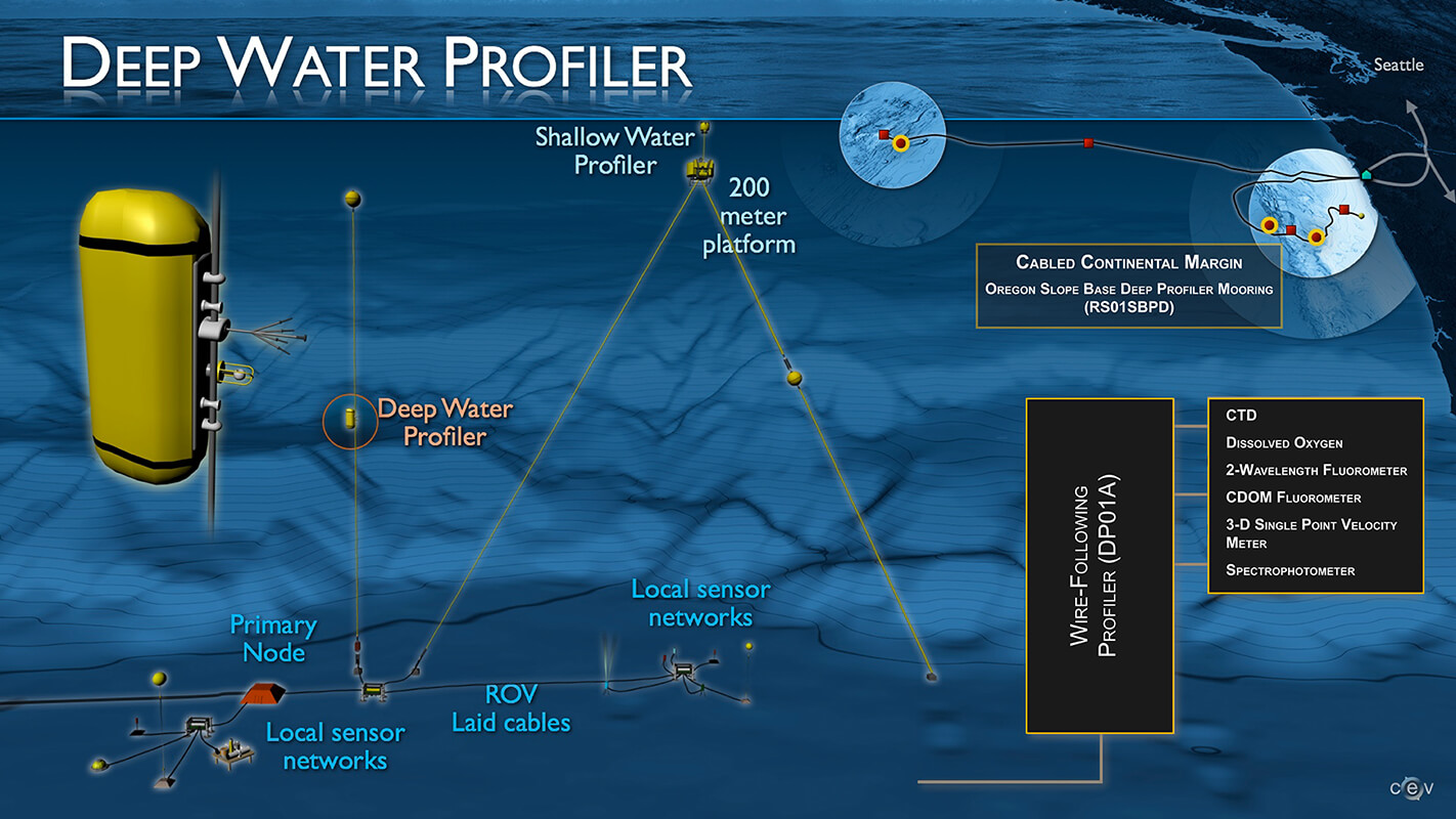
Profiler Mooring
Profiler Moorings are moorings that have sensing instruments fixed to a component that move up and down through the water creating a vertical “profile” of the water column. Profilers either track along the mooring riser (wire-following profilers), or include a winch that out line of fiber optic cable allowing the profiler, sometimes called the science pod, to move up and down through the water (e.g., Shallow Profilers on the Regional Cabled Array) and in some cases pierce the surface (e.g., Surface Piercing Profilers on the Coastal Array). Instruments also are attached directly to the mooring riser or affixed to an underwater platform on Profiler Moorings. Data from RCA moorings are transmitted to shore in real-time via the fiber optic cables. A subset of data for uncabled moorings with surface expressions are transmitted via satellite, however, most of the uncabled data are downloaded following recovery of the moorings each year. More detail on profilers can be found here.
OOI Sites with Profiler Moorings
Surface Mooring
A Surface Mooring is a type of mooring that includes a surface buoy floating on the sea surface and instruments located at fixed depths through the water column. Surface instruments are secured to the buoy, which allows them to collect data from both the air and the water. Surface Moorings have solar and wind power-generation capabilities, as well as antennas for satellite and line-of-sight communications.
Surface Moorings are located on both Coastal and Global Arrays. Surface Moorings on Coastal Arrays use technology, such as stretch hoses, to withstand large tidal fluctuations and rough seas while powering and communicating with instruments on the seabed. Global Surface Moorings are designed to withstand rough sea conditions associated with high latitudes and deep, open ocean sites. Surface Moorings are paired with Profiler Moorings to allow comparison of time series data at a few discrete depths with the high vertical resolution profiler data.
Shallow Water Mooring
The Shallow Water Mooring contains instruments attached to a Surface Buoy floating on the sea surface, the wave-powered Wire Following Profiler, and a Multi-Function Node (MFN) located on the seafloor. The Profiler and the MFN instruments communicate with the Surface Buoy through the inductive riser wire. Additionally the Surface Buoy contains antennas to transmit data to shore via satellite. Shallow Water Moorings are specifically designed to measure the upper 80% of the water column. The stretch hose, which provides compliance during rough seas or large tidal fluctuations, is at the bottom of the mooring. This allows the wave energy acting on the buoy to power the Wire-Following Profiler. It also allows the Profiler to profile within 2 meters of the sea surface.
OOI Sites with Surface Moorings
Mooring Types
 Source: Woods Hole Oceanographic Institution