Understanding Factors Controlling Seismic Activity Along the Cascadia Margin
Excerpted from the OOI Quarterly Report, 2022.
The Cascadia Subduction Zone extends from northern California to British Columbia. It has experienced magnitude 9 megathrust events with a reoccurrence rate of every ~500 years over the past 10,000 years [5] and large earthquakes at intervals of ~ 200-1200 years [6]. The last Cascadia megathrust rupture occurred on January 26, 1700 [5]. When the next event occurs, it is estimated that financial losses would be ~ $60 billion USD with substantial loss of life. Hence, there is significant research focused on understanding seismic processes along this ~ 1100 km subduction zone, the generation of slow earthquakes, and causes of variation in seismicity along strike.

Understanding the factors that control seismic events was/is a major driver in the siting of OOI-RCA core geophysical instrumentation on the southern line of the Regional Cabled Array: the RCA is one of the few places in the world where seismic-focused instrumentation occurs on both the down-going tectonic plate and on the overlying margin. The offshore network is especially valuable in determining earthquake source depths that inform on interpolate dynamics [1]. The central section of the Cascadia Margin is the only area that experiences repeat, measurable shallow crustal earthquakes [1-3]. RCA data flowing from the seismic network at Slope Base and Southern Hydrate Ridge, and from the Cascadia Initiative are providing new insights into factors controlling seismicity along this portion of the margin [1,4] (note because the RCA broadband seismometers are buried, they have lower noise levels at higher frequencies than the Cascadia Initiative instruments [1]).
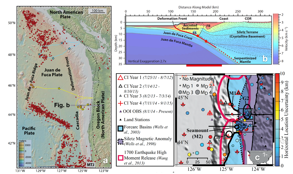
Most recently, Morton et al., [4] examined data from the Cascadia Initiative [7] and the RCA. Shallow earthquakes are focused in the area of a subducted seamount [1-3] and another cluster to the north (Fig. 1b and c). Based on earthquake locations, they suggest that subduction of the seamount produces stress heterogeneities, faulting, fracturing of the overriding Siletz terrane (old oceanic crust) (Fig 1b), and fluid movement promoting seismic swarms. Because this area is the most seismically active area along the Cascadia margin, it is an optimal area to examine the impacts of local earthquakes on, for example, gas hydrate deposits and fluid expulsion.
[1] Tréhu, A.M., Wilcock, W.S.D., Hilmo, R., Bodin, P., Connolly, J., Roland, E.C., and Braunmiller, R., (2018) The role of the Ocean Observatories Initiative in Monitoring the offshore earthquake activity of the Cascadia Subduction Zone. Oceanography, 31, 104-113. [2] Tréhu, A.M., Blakely, R.J., and Williams, M., (2012) Subducted seamounts and recent earthquakes beneath the central Cascadia Forearc. Geology, 40, 103-106. [3] Tréhu, A.M., Braunmiller, J., and Davis, E., (2015) Seismicity of the Central Cascadia Continental Margin near 44.5° N: a decadal view. Seismological Research Letters, 86, 819-829. [4] Morton, Bilek, S.L., and Rowe, C.A. (2018) Newly detected earthquakes in the Cascadia subduction zone linked to seamount subduction and deformed upper plate. Geology, 46, 943-946. [5] Satake, K.Shimazaki, K., Tsuji, Y., and Ueda, K., (1996) Time and size of a giant earthquake in Cascadia inferred from Japanese tsunami records of January 1700. Nature, 379, 246-249. [6] Goldfinger, C., Nelson, C.H., Eriksson, E., et al., (2012) Turbidite event history: Methods and implications for Holocene paleoseismicity of the Cascadia Subduction Zone. US Geological Survey Professional Paper (1661-F), 184 pp. [7] Toomey, D.R., Allen, R.M., Barclay, A.H., Bell, S.W., Bromirski, P.D. et al., (2014) The Cascadia Initiative: A sea change in seismological studies of subduction zones. Oceanography, 27, 138-150.
