Skip to content
Ocean Observatories Initiative
Subscribe Access Data Help
  • The Observatory
    • About OOI
      • The Vision
      • Leadership
      • Program Documents
      • Advisory Committees
      • Glossary
    • Arrays
      • Global Irminger Sea Array
      • Global Station Papa Array
      • Coastal Endurance Array
      • Coastal Pioneer Mid-Atlantic Bight Array
      • Coastal Pioneer New England Shelf Array
      • Regional Cabled Array
      • Cabled Continental Margin Array
      • Cabled Axial Seamount Array
      • Cabled Endurance Array
      • Global Argentine Basin
      • Global Southern Ocean Array
      • Additional Observing Assets in the Region
    • Expeditions
    • Infrastructure
      • Cabled Infrastructure
      • Moorings
      • Profilers
      • AUVs
      • Gliders
      • Cyberinfrastructure
      • Infrastructure Status
    • Instruments
    • Platforms and Nodes
  • Science
    • Publications
      • OOI-Related Publications
      • Submit a Publication
    • Science Highlights
    • Science Questions
    • Projects and Related Research
  • Participate in OOI
    • Adding Instruments or Platforms
    • Participating in Cruises
    • Deploying in OOI Areas
    • Developing a Proposal
    • Propose Modifications to Sampling
    • Borrowing OOI Equipment
  • Community Engagement
    • OOI Ambassador Program
    • Science User Group for Research meetings
    • Communities
      • Educators
      • Mariners
    • Newsletter
    • Events
    • Visual Galleries
    • Media
    • Webinar Archive
    • Join Us
  • OOI Data
    • Data Access
      • Data Explorer
    • Data Quality
      • Changes Affecting Data
    • Data Products
      • Data Products List
    • Community Datasets
    • Community Data Tools
    • Jupyter Notebook
    • How to Use, Acknowledge, and Cite Data
    • Data HelpDesk
      • Tutorials
      • FAQs (Knowledge Base)
      • Discourse
  • Resources
    • For Educators
    • Image Gallery
    • Video Gallery
    • Glossary
    • Contact
  • Home
Ocean Observatories Initiative
Subscribe Access Data Help
  • Skip to main content
  • Skip to Navigation
  • The Observatory
    • About OOI
      • The Vision
      • Leadership
      • Program Documents
      • Advisory Committees
      • Glossary
    • Arrays
      • Global Irminger Sea Array
      • Global Station Papa Array
      • Coastal Endurance Array
      • Coastal Pioneer Mid-Atlantic Bight Array
      • Coastal Pioneer New England Shelf Array
      • Regional Cabled Array
      • Cabled Continental Margin Array
      • Cabled Axial Seamount Array
      • Cabled Endurance Array
      • Global Argentine Basin
      • Global Southern Ocean Array
      • Additional Observing Assets in the Region
    • Expeditions
    • Infrastructure
      • Cabled Infrastructure
      • Moorings
      • Profilers
      • AUVs
      • Gliders
      • Cyberinfrastructure
      • Infrastructure Status
    • Instruments
    • Platforms and Nodes
    Quick Links
    • Home
    • Data Portal
    • Data Explorer
    • Partner Data Sites
    • How to Use, Acknowledge, and Cite Data
    • How to Participate
    • Infrastructure Status
    • Need Help?
  • Science
    • Publications
      • OOI-Related Publications
      • Submit a Publication
    • Science Highlights
    • Science Questions
    • Projects and Related Research
    Quick Links
    • Home
    • Data Portal
    • Data Explorer
    • Partner Data Sites
    • How to Use, Acknowledge, and Cite Data
    • How to Participate
    • Infrastructure Status
    • Need Help?
  • Participate in OOI
    • Adding Instruments or Platforms
    • Participating in Cruises
    • Deploying in OOI Areas
    • Developing a Proposal
    • Propose Modifications to Sampling
    • Borrowing OOI Equipment
    Quick Links
    • Home
    • Data Portal
    • Data Explorer
    • Partner Data Sites
    • How to Use, Acknowledge, and Cite Data
    • How to Participate
    • Infrastructure Status
    • Need Help?
  • Community Engagement
    • OOI Ambassador Program
    • Science User Group for Research meetings
    • Communities
      • Educators
      • Mariners
    • Newsletter
    • Events
    • Visual Galleries
    • Media
    • Webinar Archive
    • Join Us
    Quick Links
    • Home
    • Data Portal
    • Data Explorer
    • Partner Data Sites
    • How to Use, Acknowledge, and Cite Data
    • How to Participate
    • Infrastructure Status
    • Need Help?
  • OOI Data
    • Data Access
      • Data Explorer
    • Data Quality
      • Changes Affecting Data
    • Data Products
      • Data Products List
    • Community Datasets
    • Community Data Tools
    • Jupyter Notebook
    • How to Use, Acknowledge, and Cite Data
    • Data HelpDesk
      • Tutorials
      • FAQs (Knowledge Base)
      • Discourse
    Quick Links
    • Home
    • Data Portal
    • Data Explorer
    • Partner Data Sites
    • How to Use, Acknowledge, and Cite Data
    • How to Participate
    • Infrastructure Status
    • Need Help?
  • Resources
    • For Educators
    • Image Gallery
    • Video Gallery
    • Glossary
    • Contact
    Quick Links
    • Home
    • Data Portal
    • Data Explorer
    • Partner Data Sites
    • How to Use, Acknowledge, and Cite Data
    • How to Participate
    • Infrastructure Status
    • Need Help?
Home :: What's New ::New Discrete Water Sampling Spreadsheets Available
February 3, 2021

New Discrete Water Sampling Spreadsheets Available

By ooistaff | February 3, 2021 | Comments Off on New Discrete Water Sampling Spreadsheets Available
Comparison of pCO2 data from the PCO2W instrument on the Pioneer Central Surface Mooring seafloor Multi-Function Node with water sampling data from Pioneer Cruises AT27 and AT31.

To provide context and comparison for data collected by OOI instrumentation, OOI collects and disseminates data collected by shipboard underway sensors and from water samples from CTD casts. Shipboard underway data can be accessed by using username and password ‘guest’ on the OOI Alfresco Document Management System, organized by cruise. Each cruise folder contains a Ship Data folder in the format provided by the ship operators and a Water Sampling subfolder. The Water Sampling subfolder includes scanned and digitized versions of the CTD logs, as well as, discrete water sample analyses in the formats provided by the labs which conducted the analyses. 

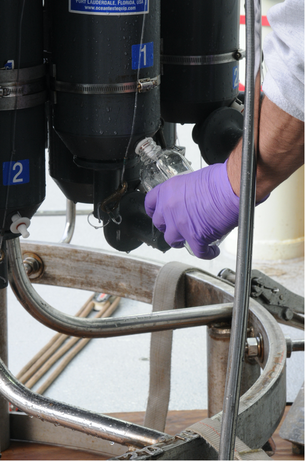
Collecting water samples from the CTD rosette on the Pioneer 8 cruise aboard the R/V Neil Armstrong. ©WHOI.

To make these data more easily accessible to the science community, we have developed a common template to provide a full set of discrete water sample data from a cruise. These “Discrete_Sample_Summary” spreadsheets include the details for each Niskin bottle fired on a CTD cast, the CTD instrument rosette data from the time of bottle closure, and the water sample data and quality flags based on World Ocean Circulation Experiment (WOCE) standards.

These CSV files with common data formats can easily be read and manipulated in MATLAB, Python, or other computing programs and languages. Because water analysis data are received at different times from different labs, these spreadsheets are updated as data become available.  An accompanying README file contains version history, general notes, and a description of the quality flags. The original spreadsheets from labs, which may contain additional data and methodology, will also be posted.

An example of how to read and use this discrete sample data can be found in this Jupyter notebook. Discrete_Sample_Summary spreadsheets have been posted for the Regional Cabled Array cruises 6-10, the Coastal Endurance Array cruises 1-13, and the Global Irminger Sea Array cruises 1-6.  We will continue to work on completing spreadsheets for past cruises as well as cruises going forward.

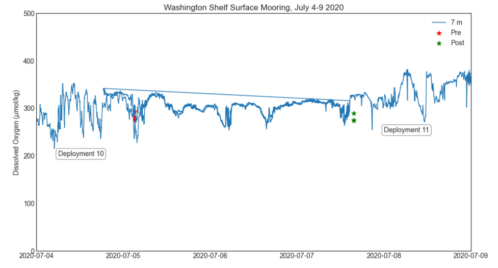
Comparison of dissolved oxygen data on the Washington Shelf Surface Mooring with water sampling data from Endurance Cruise 13. Data from Deployment 10 and Deployment 11 are plotted together, and overlap during 5-7 July.

  • The Observatory
    • About OOI
      • The Vision
      • Leadership
      • Program Documents
      • Advisory Committees
      • Glossary
    • Arrays
      • Global Irminger Sea Array
      • Global Station Papa Array
      • Coastal Endurance Array
      • Coastal Pioneer Mid-Atlantic Bight Array
      • Coastal Pioneer New England Shelf Array
      • Regional Cabled Array
      • Cabled Continental Margin Array
      • Cabled Axial Seamount Array
      • Cabled Endurance Array
      • Global Argentine Basin
      • Global Southern Ocean Array
      • Additional Observing Assets in the Region
    • Expeditions
    • Infrastructure
      • Cabled Infrastructure
      • Moorings
      • Profilers
      • AUVs
      • Gliders
      • Cyberinfrastructure
      • Infrastructure Status
    • Instruments
    • Platforms and Nodes
  • Science
    • Publications
      • OOI-Related Publications
      • Submit a Publication
    • Science Highlights
    • Science Questions
    • Projects and Related Research
  • Participate in OOI
    • Adding Instruments or Platforms
    • Participating in Cruises
    • Deploying in OOI Areas
    • Developing a Proposal
    • Propose Modifications to Sampling
    • Borrowing OOI Equipment
  • Community Engagement
    • OOI Ambassador Program
    • Science User Group for Research meetings
    • Communities
      • Educators
      • Mariners
    • Newsletter
    • Events
    • Visual Galleries
    • Media
    • Webinar Archive
    • Join Us
  • OOI Data
    • Data Access
      • Data Explorer
    • Data Quality
      • Changes Affecting Data
    • Data Products
      • Data Products List
    • Community Datasets
    • Community Data Tools
    • Jupyter Notebook
    • How to Use, Acknowledge, and Cite Data
    • Data HelpDesk
      • Tutorials
      • FAQs (Knowledge Base)
      • Discourse
  • Resources
    • For Educators
    • Image Gallery
    • Video Gallery
    • Glossary
    • Contact

NSF LogoOOI Logo

The Ocean Observatories Initiative (OOI) is a science-driven ocean observing network that delivers real-time data from more than 900 instruments to address critical science questions regarding the world’s oceans.

  • About OOI
    • Science
    • The Ocean Observatories Initiative
    • Data Products
    • Contact
  • Resources
    • Community Data Tools
    • Data Access
    • OOI Ambassador Program
    • OOI Knowledge Base
    • Glossary
    • Need Help?
  • Join Us
    • How to Participate
    • Workshops/Conferences

Stay Connected

Sign up for our newsletter to get the latest news from Ocean Observatories Initiative

Subscribe now
Join the Conversation

© 2025 Ocean Observatories Initiative. All Rights Reserved. The Ocean Observatories Initiative is a major facility fully funded by the National Science Foundation.

Any opinions, findings, and conclusions or recommendations expressed in this material do not necessarily reflect the views of the National Science Foundation. Internal | PMO/MIO Log in
Scroll To Top