The Great Salinity Anomaly of 2015-2020
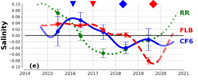
The Great Salinity Anomaly of 2015-2020. Adapted by OOI from Biló et al., 2022.

Unusual surface freshening episodes in the Subpolar North Atlantic have been documented since the 1960s when the term Great Salinity Anomaly (GSA) was coined to refer to the first documented event (Dickson et al., 1988). GSAs are of great importance because the reduction in surface density of North Atlantic surface waters increases vertical stratification, suppresses deep water formation, and weakens the Atlantic Meridional Overturning Circulation (AMOC). Deep (700-1000 m) wintertime convection in the Irminger and Labrador Seas creates the water mass constituting the northern portion of the AMOC’s lower limb, which transports cold water back to southern latitudes. Thus, sustained changes to deep water formation due to a GSA will impact the global climate system.
New work by Bilo et al. (2022) argues that there has been another GSA during 2015-2020, with significant salinity reduction in the upper 200 m of the Iceland Basin and Irminger Sea. The authors use hydrographic data and moored observations to document the spatial extent and propagation pathways of the GSA.
Hydrographic data come from the Argo float monthly climatology and from UK Met Office Hadley Centre “enhanced” version 4 (EN4) historical hydrography. These spatial data sets allow the basin-wide salinity changes to be diagnosed, and show that between 2015 and 2020 the upper 200 m of the central Irminger Sea freshened by 0.1-0.2 PSU. The observed freshening rate of up to 0.04 PSU per year is among the fastest salinity decreases ever recorded in the region. The regional maps show the freshening first in the Iceland Basin and later in the Irminger Sea.
Moored observations come from the Overturning in the Subpolar North Atlantic Program (OSNAP) and from the OOI Irminger Sea Array. Two OSNAP moorings are evaluated, one on the eastern side of the Irminger Sea near the Reykjanes Ridge and one on the western side within the southward-flowing boundary current. OOI Flanking Mooring B was used to represent conditions in the central Irminger Sea. The results (Figure above) show a salinity minimum near the Reykjanes Ridge in 2017 followed by a minimum at the western boundary in 2018 and finally a significant (~0.1 PSU) salinity reduction in the Irminger Sea interior in 2019. Estimated transit times from the mooring data indicate that the salinity signal is advected quickly (months) by Irminger Sea boundary currents after crossing the Reykjanes Ridge and then spreads more slowly to the interior, taking of order two years to impact the central Irminger Sea.
The authors note that although climatologies are important to determine regional changes, these data are mostly limited to deep water. Moorings can provide data within the boundary currents, as well as well-resolved temporal evolution at multiple locations. This underscores the importance of a hybrid ocean observing system combining historical climatologies, broad spatial coverage (Argo), and time series data (OSNAP, OOI).
_______________________________________________
Biló, T.C., F. Straneo, J. Holte and I. Le Bras, (2022). Arrival of new Great Salinity Anomaly weakens convection in the Irminger Sea. Geophysical Research Letters, 49, e2022GL098857, doi:10.1029/2022GL098857.
Dickson, R.R., J. Meincke, S.-A. Malmberg, and A.J. Lee (1988). The great salinity anomaly in the Northern North Atlantic 1968–1982″. Progress in Oceanography, 20 (2): 103–151, doi:10.1016/0079-6611(88)90049-3.
