
Oregon Offshore Surface Mooring (CE04OSSM)
The Coastal Endurance Oregon Offshore Surface Mooring is located on the Continental Slope, approximately 550 meters deep. The Continental Shelf-Slope area off the Oregon coast is a highly productive, dynamic upwelling environment.
Platform DOI and Citation Guidance
OOI assigns Digital Object Identifiers (DOIs) at the platform or site level. The DOI for the Coastal Endurance Oregon Offshore Surface Mooring is 10.58046/OOI-CE04OSSM.
The minimum recommended citation for this platform is:
NSF Ocean Observatories Initiative. (2015). Coastal Endurance Oregon Offshore Surface Mooring, DOI: 10.58046/OOI-CE04OSSM.
This follows the format NSF Ocean Observatories Initiative. (Year Published). Platform title, DOI: Platform DOI, where Year Published is the year OOI data collection began at the site.
We encourage data users to incorporate full citations when referencing OOI data in order to support FAIR data principles and data traceability. OOI also provides further guidance on citations, including information on adding specific data products and data access points to citations.
Data Access
The following links provide data access via Data Explorer or other methods:
- Direct access to the data on this platform and its subcomponents
- General access to OOI data using a variety of methods
Platform Description
The Coastal Endurance Oregon Offshore Surface Mooring is located on the Continental Slope, approximately 550 meters deep. The Continental Shelf-Slope area off the Oregon coast is a highly productive, dynamic upwelling environment. Upwelling brings nutrients to the surface sparking primary production and fueling the food web. In recent years, upwelling has also brought onto the shelf hypoxic, low oxygen, waters that can be harmful to organisms in the area. By sampling in this area, the OOI seeks to gain better insight into upwelling dynamics of this system.
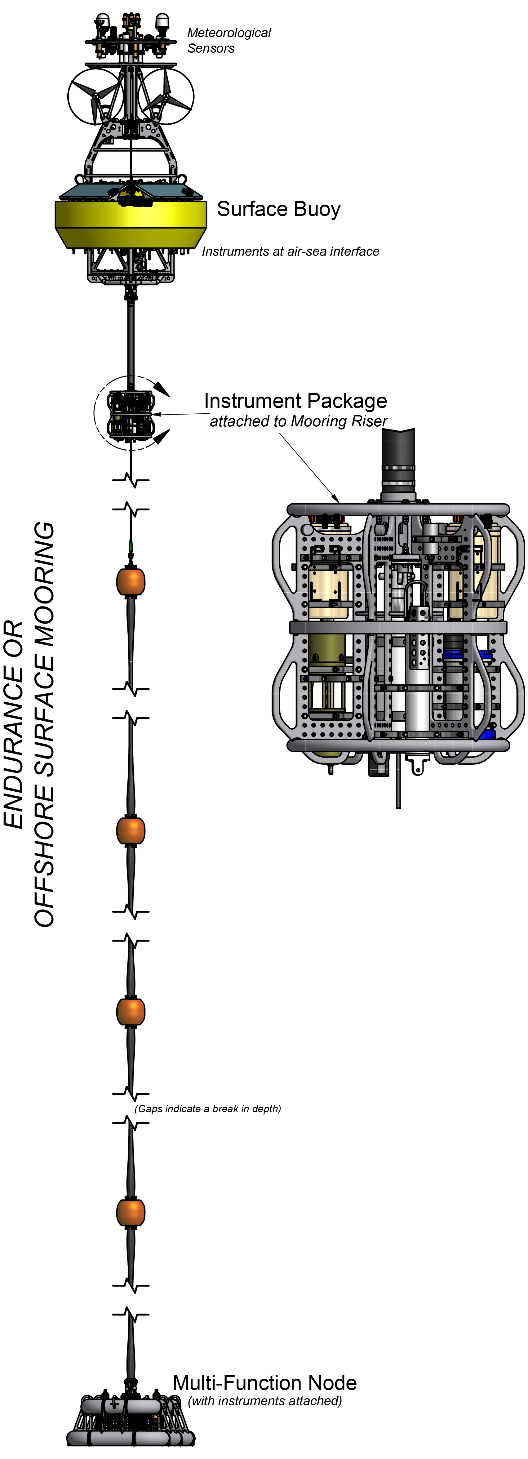
Like other coastal moorings, the Coastal Endurance Oregon Offshore Surface Mooring is specifically designed to examine coastal-scale phenomena and withstand the challenging conditions of shallow coastal environments, including large tidal fluctuations. The Surface Mooring contains instruments attached to a Surface Buoy floating on the sea surface, Near Surface Instrument Frame 7 meters below the surface, and a Seafloor Multi-Function Node (MFN) located on the seafloor. The Surface Buoy provides a platform on which to secure surface instruments above the sea surface, below the sea surface, and across the interface between. Additionally the Surface Buoy contains an antenna to transmit data to shore via satellite.
Instruments
This site/platform includes the following instruments. To learn more about an instrument type, select the instrument class-series. To access relevant data streams for an instrument, the instrument code will take you to the OOI Data Portal.
| Instrument Code | Depth | Node | Instrument Class-Series |
Make & Model |
|---|---|---|---|---|
| CE04OSSM-SBD11-01-MOPAK0000 | 0m | Surface Buoy | 3-Axis Motion Pack (MOPAK0) | MicroStrain - 3DM-GX3-25 |
| CE04OSSM-RID27-02-FLORTD000 | 7m | Near Surface Instrument Frame | 3-Wavelength Fluorometer (FLORTD) | WET Labs - ECO Triplet-w |
| CE04OSSM-SBD11-06-METBKA000 | -3m | Surface Buoy | Bulk Meteorology Instrument Package (METBKA) | Star Engineering - ASIMET |
| CE04OSSM-RID27-03-CTDBPC000 | 7m | Near Surface Instrument Frame | CTD (CTDBPC) | Sea-Bird - SBE 16plusV2 |
| CE04OSSM-SBD11-00-DCLENG000 | 0m | Surface Buoy | Data Concentrator Logger (DCLENG) | WHOI - Data Concentrator Logger |
| CE04OSSM-SBD12-00-DCLENG000 | 0m | Surface Buoy | Data Concentrator Logger (DCLENG) | WHOI - Data Concentrator Logger |
| CE04OSSM-RID26-00-DCLENG000 | 7m | Near Surface Instrument Frame | Data Concentrator Logger (DCLENG) | WHOI - Data Concentrator Logger |
| CE04OSSM-RID27-00-DCLENG000 | 7m | Near Surface Instrument Frame | Data Concentrator Logger (DCLENG) | WHOI - Data Concentrator Logger |
| CE04OSSM-RID27-04-DOSTAD000 | 7m | Near Surface Instrument Frame | Dissolved Oxygen (DOSTAD) | Aanderaa - Optode 4831 |
| CE04OSSM-SBD11-02-HYDGN0000 | 0m | Surface Buoy | Hydrogen Sensor (HYDGN0) | RKI Instruments - M2A transmitters |
| CE04OSSM-SBD12-03-HYDGN0000 | 0m | Surface Buoy | Hydrogen Sensor (HYDGN0) | RKI Instruments - M2A transmitters |
| CE04OSSM-RID26-07-NUTNRB000 | 7m | Near Surface Instrument Frame | Nitrate (NUTNRB) | Sea-Bird - SUNA V2 |
| CE04OSSM-SBD12-04-PCO2AA000 | 0m | Surface Buoy | pCO2 Air-Sea (PCO2AA) | Pro-Oceanus - pCO2-pro |
| CE04OSSM-SBC11-00-CPMENG000 | 0m | Surface Buoy | Platform Controller (CPMENG) | WHOI - Communications and Power Manager |
| CE04OSSM-RIC21-00-CPMENG000 | 7m | Near Surface Instrument Frame | Platform Controller (CPMENG) | WHOI - Communications and Power Manager |
| CE04OSSM-RID26-06-PHSEND000 | 7m | Near Surface Instrument Frame | Seawater pH (PHSEND) | Sunburst - SAMI-pH |
| CE04OSSM-SBD11-04-VELPTA000 | 1m | Surface Buoy | Single Point Velocity Meter (VELPTA) | Nortek - Aquadopp 300m |
| CE04OSSM-RID26-04-VELPTA000 | 7m | Near Surface Instrument Frame | Single Point Velocity Meter (VELPTA) | Nortek - Aquadopp 300m |
| CE04OSSM-RID26-08-SPKIRB000 | 7m | Near Surface Instrument Frame | Spectral Irradiance (SPKIRB) | Satlantic - OCR507 ICSW |
| CE04OSSM-RID27-01-OPTAAD000 | 7m | Near Surface Instrument Frame | Spectrophotometer (OPTAAD) | WET Labs - AC-S |
| CE04OSSM-SBD12-05-WAVSSA000 | 0m | Surface Buoy | Surface Wave Spectra (WAVSSA) | Axys Technologies - TRIAXYS |
| CE04OSSM-RID26-01-ADCPTC000 | 7m | Near Surface Instrument Frame | Velocity Profiler (300kHz) (ADCPTC) | Teledyne RDI - WorkHorse Sentinel 300khz |
Equipment Diagram
Water Depth
588 meters
Location
44.3811°N, 124.956°W