Coastal Pioneer Mid-Atlantic Bight Array

The Pioneer Mid-Atlantic Bight (MAB) Array, located off the coast of North Carolina, consists of a mooring array supplemented by glider and AUV transects. The MAB continental shelf north of Cape Hatteras is characterized by a persistent equator-ward current originating from the north, a shelfbreak front separating shelf and slope waters, distributed buoyancy inputs from rivers, variable wind forcing, and intermittent offshore forcing by Gulf Stream meanders. The Pioneer MAB Array is designed to resolve transport processes and ecosystem dynamics in the vicinity of the shelfbreak front, which is a region of complex oceanographic dynamics, intermittent mesoscale variability, and enhanced biological productivity. The Array collects high-resolution, multidisciplinary, measurements spanning the continental shelf and slope on horizontal scales from a few kilometers to about one hundred kilometers.
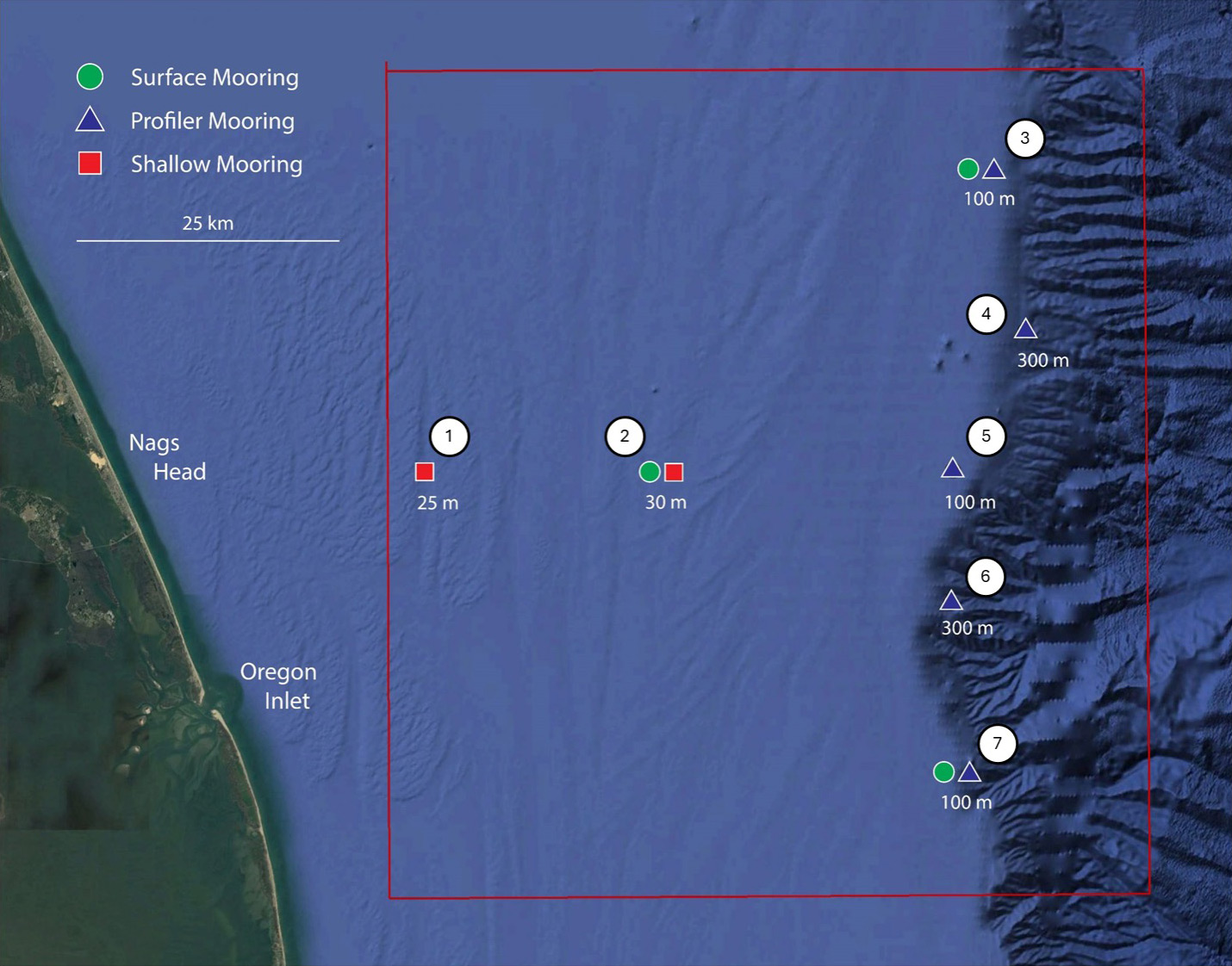
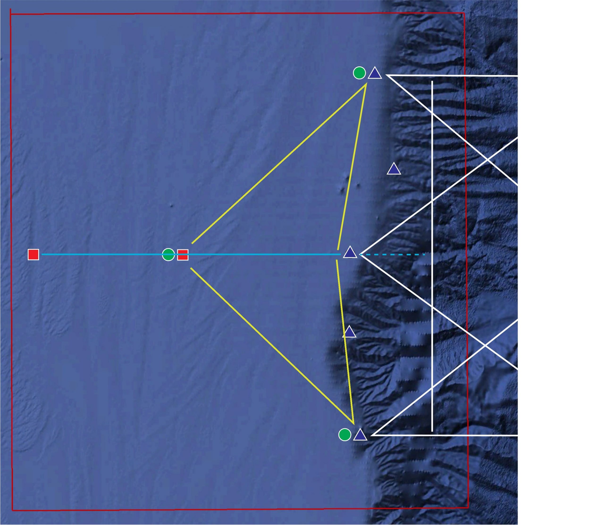
The backbone of the Pioneer Array is a frontal-scale, T-shaped moored array located off the coast of Nags Head, North Carolina, starting ~25 km offshore and extending ~50 km east/west and ~50 km north/south across the continental shelf, centered near the shelf-break front. Three electro-mechanical surface moorings and seven profiler moorings occupy the array. Each surface mooring incorporates a surface buoy with multiple sources of power generation and multiple surface and subsurface communications systems. The surface moorings support a Near-Surface Instrument Frame (NSIF) and are anchored by an instrumented Multi-Function Node (MFN) on the seafloor. Five profiler moorings with surface expressions for data telemetry support wire-following profiling packages with a multidisciplinary sensor suite. Two shallow-water profiler moorings support a wave-powered profiler capable of sampling the upper 80% of the water column, to within a few meters of the air-sea interface. The ten moorings occupy seven sites; three sites contain both a surface mooring and a profiler mooring.
In order to provide synoptic, multi-scale observations of the outer continental shelf, shelf break region, and continental slope, the moored array is supplemented by six mobile platforms – four Coastal Gliders and two AUVs. The role of the gliders is to provide transects along and across the shelf, and to monitor the mesoscale field of the slope sea, resolving rings, eddies and meanders from the Gulf Stream as they impinge on the shelfbreak front. The AUVs provide synoptic across- and along-front transects – “snap shots” of the front on time scales shorter than those on which the system changes.
Community Process to Relocate Coastal Pioneer Array from the New England Shelf to the Mid-Atlantic Bight.
Sites/Platforms
This array includes following research sites and platforms.
| Key | Site/Platform Name | Water Depth | DOI |
|---|---|---|---|
| Pioneer MAB Glider Mobile Assets (CP15MOAS) | 30 – 1000 meters | 10.58046/OOI-CP15MOAS | |
| Pioneer MAB AUV Mobile Assets (CP16MOAS) | 30 – 1000 meters | 10.58046/OOI-CP16MOAS | |
| 1 | Western Shallow Water Mooring (CP12WESW) | 25 meters | 10.58046/OOI-CP12WESW |
| 2 | Central Surface Mooring (CP10CNSM) | 30 meters | 10.58046/OOI-CP10CNSM |
| 2 | Central Shallow Water Mooring (CP12CNSW) | 30 meters | 10.58046/OOI-CP12CNSW |
| 3 | Northern Surface Mooring (CP11NOSM) | 100 meters | 10.58046/OOI-CP11NOSM |
| 3 | Northern Profiler Mooring (CP13NOPM) | 100 meters | 10.58046/OOI-CP13NOPM |
| 4 | Northeastern Profiler Mooring (CP14NEPM) | 300 meters | 10.58046/OOI-CP14NEPM |
| 5 | Eastern Profiler Mooring (CP13EAPM) | 100 meters | 10.58046/OOI-CP13EAPM |
| 6 | Southeastern Profiler Mooring (CP14SEPM) | 300 meters | 10.58046/OOI-CP14SEPM |
| 7 | Southern Surface Mooring (CP11SOSM) | 100 meters | 10.58046/OOI-CP11SOSM |
| 7 | Southern Profiler Mooring (CP13SOPM) | 100 meters | 10.58046/OOI-CP13SOPM |

