Cabled Array Vent Imaging Sonar (COVIS)
The Cabled Array Vent Imaging Sonar (COVIS) was originally developed by Russ Light and his team of engineers in the Ocean Engineering department of the Applied Physics Laboratory (APL), University of Washington (UW), in collaboration with scientists at both APL-UW (including Darrell Jackson) and Rutgers, The State University of New Jersey (including Peter Rona (deceased) and Karen Bemis) to image hydrothermal outflow. COVIS was initially deployed for five years on the Ocean Network Canada’s NEPTUNE observatory and then recovered in summer 2015 (publications detailing NEPTUNE results are listed on the Acoustic Imaging site.) COVIS was subsequently refurbished for installation on the OOI Regional Cabled Array by Tim McGinnis, Aaron Marburg, Anatoliy Ivakin,and others at APL-UW, in collaboration with science teams from Rutgers (Karen Bemis), Woods Hole Oceanographic Institution (Guangyu Xu – now at the UW), and Georgia Tech(Leonid Germanovich).
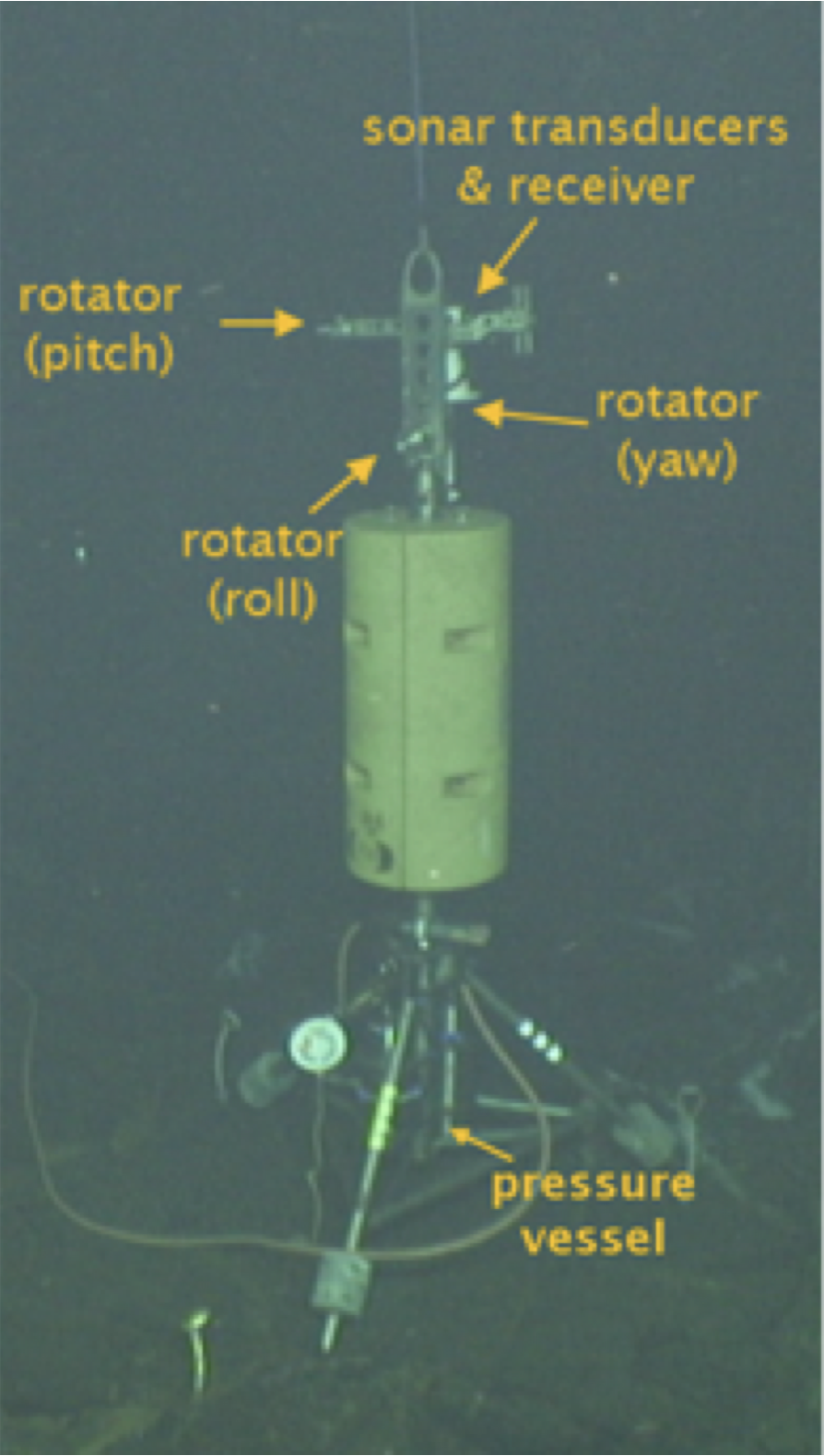
COVIS consists of a modified Reason 7125 SeaBat multi-beam sonar mounted on a novel tri-axial rotator at the top of a 4.2-m tower. The electronics and data-handling hardware are contained in a pressure vessel near the base of the tower. The source and receiver transducers on COVIS operate at two frequencies: 400 and 200 kHz.
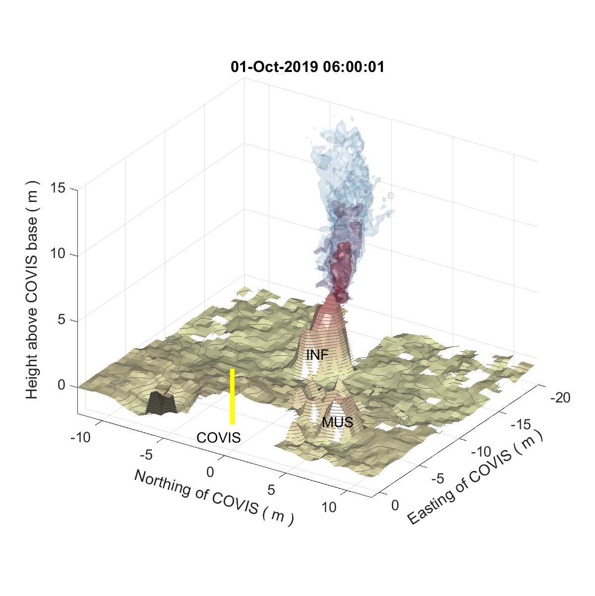
COVIS is an innovative sonar system designed specifically for long-term, quantitative monitoring of hydrothermal emissions. At 400 kHz, the system operates in the ‘Imaging’ and ‘Doppler’ modes to acquire water-column backscatter data for imaging focused hydrothermal venting and estimating the vertical velocity and fluxes, respectively. Quantifying the extent, orientation, vertical variation in backscattering strength, and vertical velocities permit the estimation of volume and heat fluxes from the venting source and the mixing rate of the rising plumes with ocean water. At 400 kHz, COVIS can also operate in a ‘Bathy’ mode to produce bathymetric maps within its imaging range.
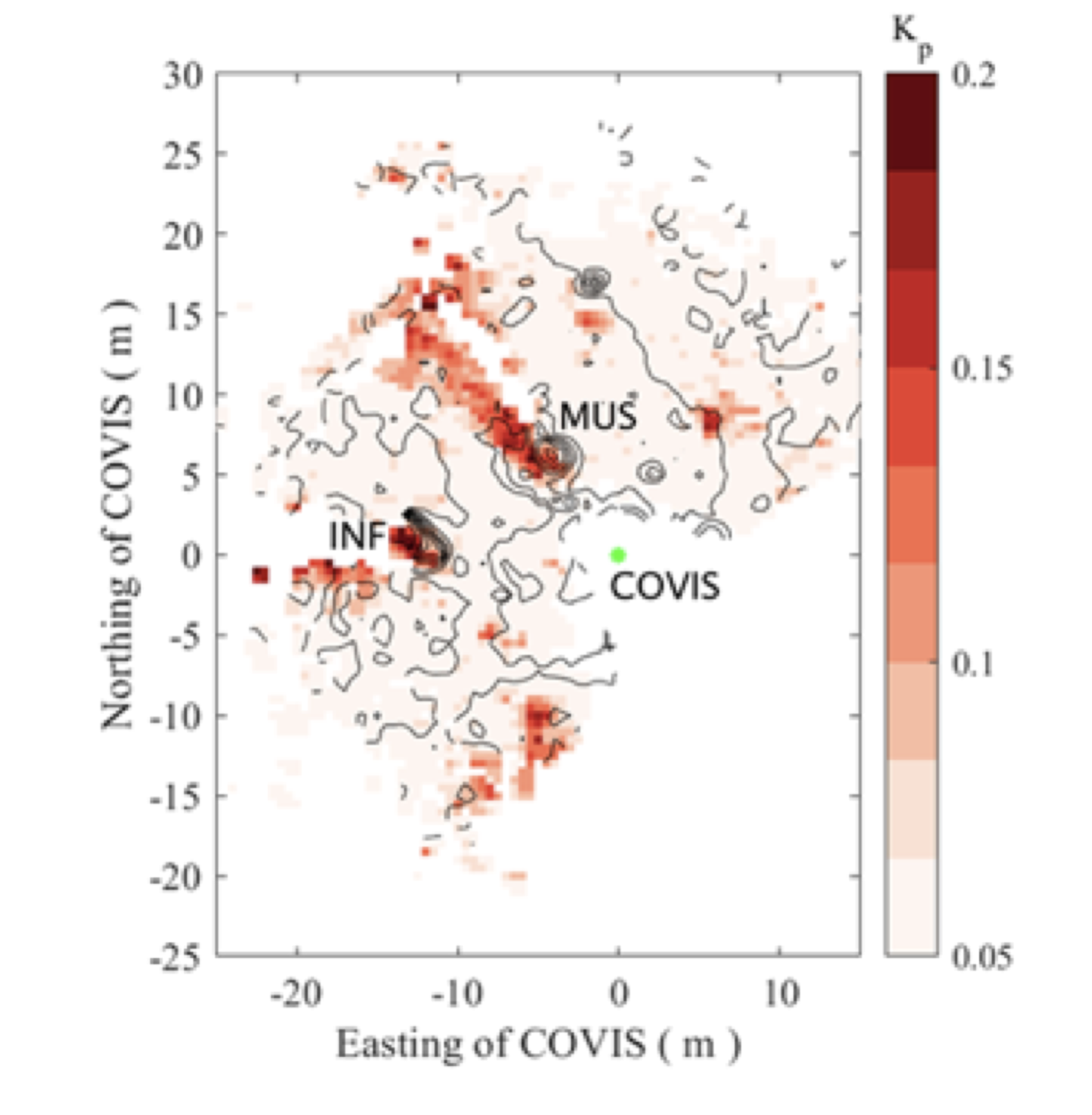
At 200 kHz, COVIS operates in the ‘Diffuse’ mode to acquire acoustic backscatter from the seafloor covered by diffuse hydrothermal discharge (Figure 1). The output of the Diffuse mode enables the production of maps of discharging areas at regular time intervals (usually hourly) every day for as long as COVIS is installed. By this means, COVIS detects changes in the spatial distributions and intensities of venting, including estimates of heat transport from more diffuse vents. Estimations of fluxes (focused and diffuse) help discern the chemical and physical interactions between the ocean and underwater volcanoes (such as Axial Seamount), which globally have a significant impact on ocean chemistry and heat balance. Another goal of this study is to detect how eruptions, seismicity, and seafloor deformation affect long-term hydrothermal venting.
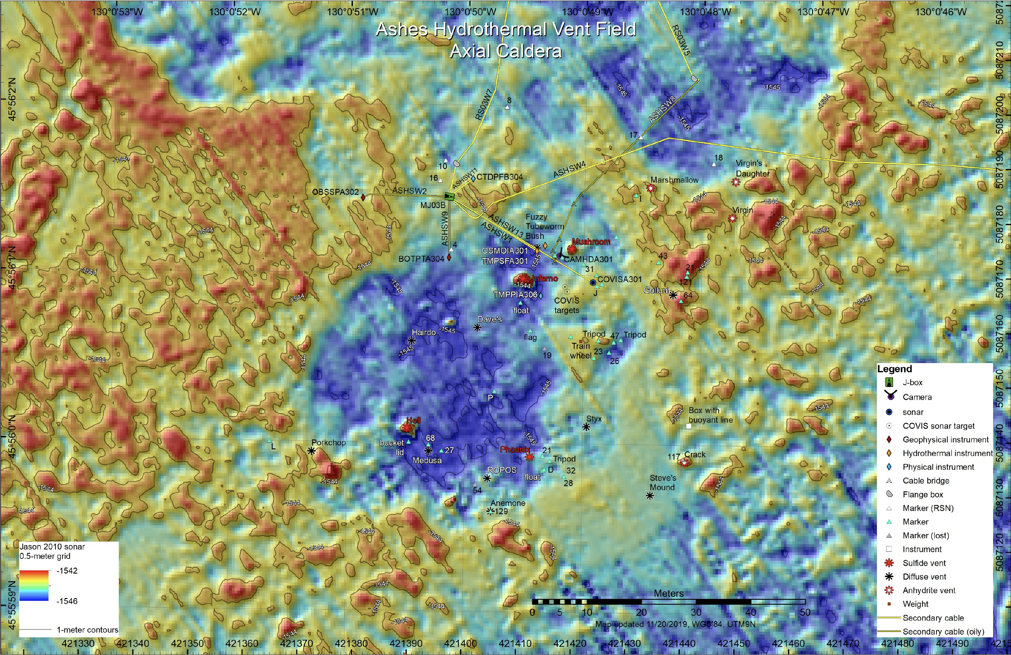
COVIS was initially installed on the 2018 Regional Cabled Array maintenance cruise (VISIONS’18) onboard the R/V Revelle (RR1812) on July 29, 2018. The platform is located in the ASHES hydrothermal vent field about 8 m southeast of the actively venting Mushroom edifice imaged by the high definition camera (CamHD) and about 13 m east of the Inferno edifice. COVIS ‘looks’ northwest and images at least a 128° sector centered on the 309° azimuth from COVIS. Except for blank spots due to Mushroom’s and Inferno’s shadows, COVIS images from 5 m to 30-50 m, depending on the strength of the backscatter from the target. COVIS produces 3D volumes of backscattering strength (Imaging and Doppler modes) and vertical velocity (Doppler mode), as well as 2D maps of seafloor backscatter variation (Diffuse mode). See data site for timing of data runs and their modes.
Recent Results
COVIS has detected a series of hot spots around the northeastern sector of ASHES which can be interpreted as a combination of diffuse and focused discharge (Figure 2). The area of the inferred diffuse discharge varies with the tidal cycle. Plumes rise above the Inferno and Mushroom hydrothermal edifices (Figure 3), and site between them near the 3D Array. The plume structure above Inferno varies significantly over every day.
Updated COVIS images and maps will soon be available at the COVIS team site, as well as the COVIS data ftp site run by OOI.
Recent Publications
Jackson, D., Bemis, K., Xu, G., and Ivakin, A. Sonar observation of heat flux of diffuse hydrothermal flows, Earth and Space Science, 9(10), e2021EA001974,2022.
Xu, G., Bemis, K., Jackson, D., and Ivakin, A. Acoustic and In‐situ Observations of Deep Seafloor Hydrothermal Discharge: an OOI Cabled Array ASHES Vent Field Case Study, Earth and Space Science, 8(3), e2020EA001269, 2021.
Access COVISA301 DataInstrument Models & Deployed Locations
COVIS was installed in the ASHES hydrothermal field at Axial Seamount at a water depth of 1545 m. The instrument is connected to the medium powered junction box MJ03B. It consists of a multibeam sonar (RESON Seabat 7125) with 2 heads (200 kHz and 400 kHz)Reference Information
Raw and processed PI instrument data for COVIS can be accessed through the Access Data link above. Within the accessed ftp site, a read me text file provides information about data formats, calibration information, and instrument data.Post-processing codeInstrument
COVISA301Investigator(s)
Karen Bemis 1, Tim McGinnis 2, Darrell Jackson 2, Aaron Marburg 2, Anatoliy Ivakin 2, Guangyu Xu 2, Leonid Gemanovich 3Affiliation(s)
1 Rutgers University, 2 Applied Physics Laboratory University of Washington, 3 Georgia Institute of TechnologyPrimary Science Discipline
Marine GeophysicsSite
ASHES Vent Field (RS03ASHS)Node
ASHES (MJ03B)Depth (m)
1545 maximumAward
Collaborative research: Heat flow mapping and quantification at ASHES hydrothermal vent field using an observatory imaging sonarFunding Agency
National Science FoundationAward site
National Science Foundation
Award site
National Science Foundation
Award site
National Science Foundation
Award site
Images