
Oregon Shelf Surface Piercing Profiler Mooring (CE02SHSP)
The Coastal Endurance Oregon Shelf Surface Piercing Profiler Mooring is located on the Continental Shelf, approximately 80 meters deep. The Continental Shelf-Slope area off the Oregon coast is a highly productive, dynamic upwelling environment.
Platform DOI and Citation Guidance
OOI assigns Digital Object Identifiers (DOIs) at the platform or site level. The DOI for the Coastal Endurance Oregon Shelf Surface Piercing Profiler Mooring is 10.58046/OOI-CE02SHSP.
The minimum recommended citation for this platform is:
NSF Ocean Observatories Initiative. (2015). Coastal Endurance Oregon Shelf Surface Piercing Profiler Mooring, DOI: 10.58046/OOI-CE02SHSP.
This follows the format NSF Ocean Observatories Initiative. (Year Published). Platform title, DOI: Platform DOI, where Year Published is the year OOI data collection began at the site.
We encourage data users to incorporate full citations when referencing OOI data in order to support FAIR data principles and data traceability. OOI also provides further guidance on citations, including information on adding specific data products and data access points to citations.
Data Access
The following links provide data access via Data Explorer or other methods:
- Direct access to the data on this platform and its subcomponents
- General access to OOI data using a variety of methods
Platform Description
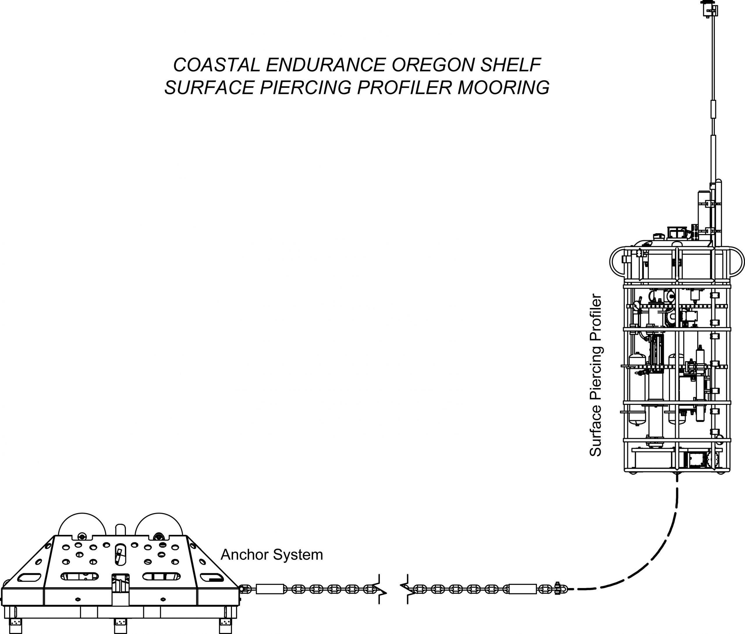
The Endurance Oregon Shelf Surface Piercing Profiler Mooring is located on the Continental Shelf, approximately 80 meters deep. The Continental Shelf-Slope area off the Oregon coast is a highly productive, dynamic upwelling environment. Upwelling brings nutrients to the surface sparking primary production and fueling the food web. In recent years, upwelling has also brought onto the shelf hypoxic, low oxygen, waters that can be harmful to organisms in the area. By sampling in this area, the OOI seeks to gain better insight into upwelling dynamics of this system.
Like other Surface Piercing Profiler Moorings, this mooring contains a Surface Piercing Profiler that allows for the sampling of near surface phenomena as the Profiler travels through the water then breaches the surface. Fine resolution sampling of the water column, particularly at the very surface of the water, provides key insights into the exchange of gases, heat, etc. between the atmosphere and the ocean. While on the surface, the profiler transmits data to shore.
Instruments
This site/platform includes the following instruments. To learn more about an instrument type, select the instrument class-series. To access relevant data streams for an instrument, the instrument code will take you to the OOI Data Portal.
| Instrument Code | Depth | Node | Instrument Class-Series |
Make & Model |
|---|---|---|---|---|
| CE02SHSP-SP001-07-FLORTJ000 | 0 to 80 meters | Surface Piercing Profiler | 3-Wavelength Fluorometer (FLORTJ) | WET Labs - ECO Triplet-w |
| CE02SHSP-SP001-08-CTDPFJ000 | 0 to 80 meters | Surface Piercing Profiler | CTD (CTDPFJ) | Sea-Bird - FastCAT 49 CTD |
| CE02SHSP-SP001-01-DOSTAJ000 | 0 to 80 meters | Surface Piercing Profiler | Dissolved Oxygen (DOSTAJ) | Aanderaa - Optode 4831 |
| CE02SHSP-SP001-05-NUTNRJ000 | 0 to 80 meters | Surface Piercing Profiler | Nitrate (NUTNRJ) | Sea-Bird - SUNA V2 |
| CE02SHSP-SP001-09-PARADJ000 | 0 to 80 meters | Surface Piercing Profiler | Photosynthetically Active Radiation (PARADJ) | WET Labs - ECO PAR |
| CE02SHSP-SP001-00-SPPENG000 | 0 to 80 meters | Surface Piercing Profiler | Profiler Controller (SPPENG) | WET Labs - AMP |
| CE02SHSP-SP001-02-VELPTJ000 | 0 to 80 meters | Surface Piercing Profiler | Single Point Velocity Meter (VELPTJ) | Nortek - Aquadopp HR |
| CE02SHSP-SP001-06-SPKIRJ000 | 0 to 80 meters | Surface Piercing Profiler | Spectral Irradiance (SPKIRJ) | Satlantic - OCR507 ICSW |
| CE02SHSP-SP001-04-OPTAAJ000 | 0 to 80 meters | Surface Piercing Profiler | Spectrophotometer (OPTAAJ) | WET Labs - AC-S |
Equipment Diagram
Water Depth
81 meters
Location
44.6372°N, 124.299°W