
Oregon Offshore Cabled Deep Profiler Mooring (CE04OSPD)
Oregon Offshore Cabled Deep Profiler Mooring is located on the Continental Slope, approximately 550 meters deep. The Continental Shelf-Slope area off the Oregon coast is a highly productive, dynamic upwelling environment.
Platform DOI and Citation Guidance
OOI assigns Digital Object Identifiers (DOIs) at the platform or site level. The DOI for the Oregon Offshore Cabled Deep Profiler Mooring is 10.58046/OOI-CE04OSPD.
The minimum recommended citation for this platform is:
NSF Ocean Observatories Initiative. (2014). Oregon Offshore Cabled Deep Profiler Mooring, DOI: 10.58046/OOI-CE04OSPD.
This follows the format NSF Ocean Observatories Initiative. (Year Published). Platform title, DOI: Platform DOI, where Year Published is the year OOI data collection began at the site.
We encourage data users to incorporate full citations when referencing OOI data in order to support FAIR data principles and data traceability. OOI also provides further guidance on citations, including information on adding specific data products and data access points to citations.
Data Access
The following links provide data access via Data Explorer or other methods:
- Direct access to the data on this platform and its subcomponents
- General access to OOI data using a variety of methods
Platform Description
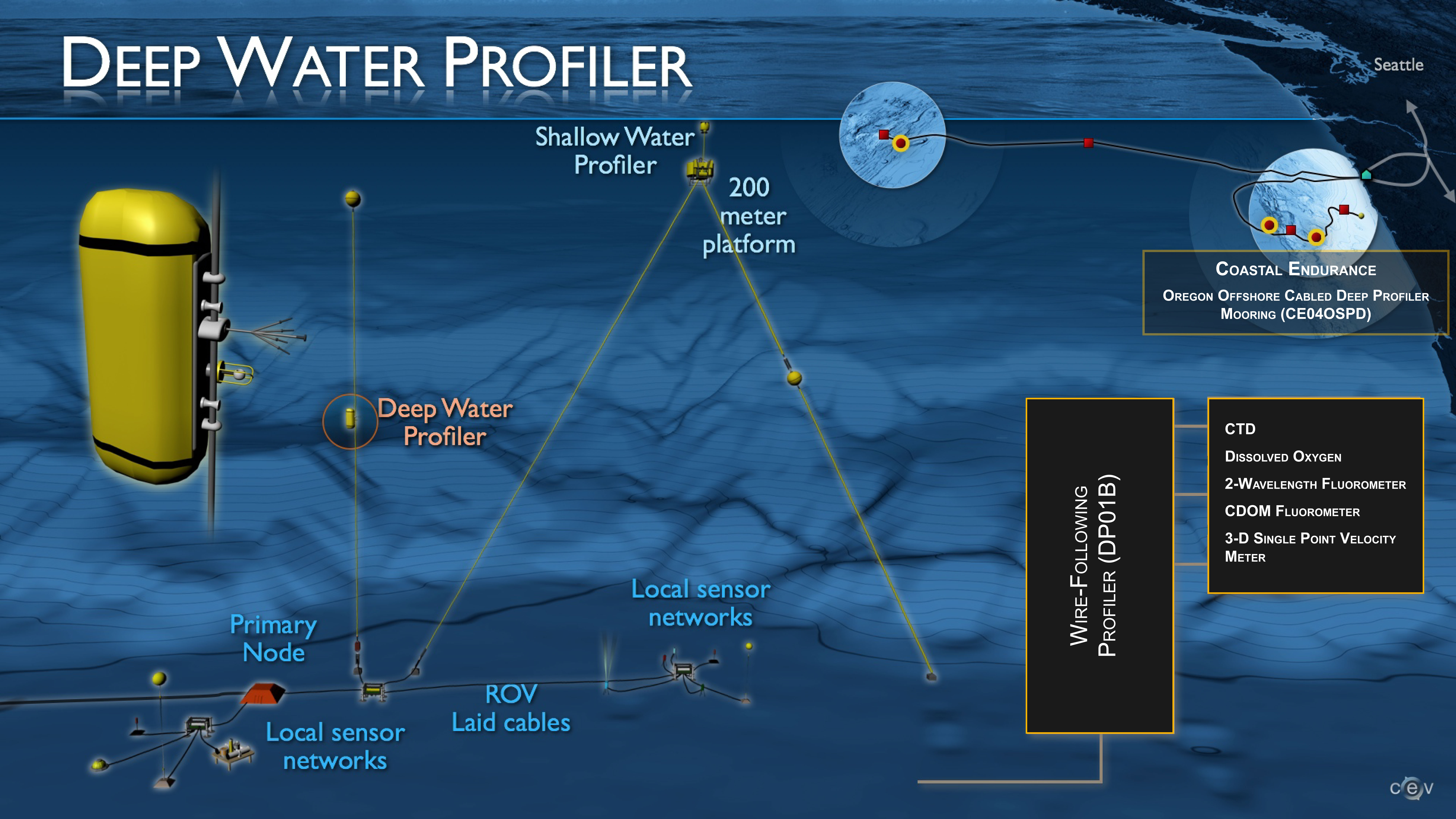
The Oregon Offshore Cabled Deep Profiler Mooring is located on the Continental Slope, approximately 550 meters deep. The Continental Shelf-Slope area off the Oregon coast is a highly productive, dynamic upwelling environment. Upwelling brings nutrients to the surface sparking primary production and fueling the food web. In recent years, upwelling has also brought onto the shelf hypoxic, low oxygen, waters that can be harmful to organisms in the area. By sampling in this area, the OOI seeks to gain better insight into upwelling dynamics of this system.
As with other Cabled Deep Profiler Moorings, this mooring contains a Wire-Following Profiler and is attached to a fiber-optic cable. The Wire-Following Profiler houses scientific instrumentation and moves through the water column along the mooring riser, continuously sampling ocean characteristics over a specified depth interval (175 meters below sea surface to near bottom). The fiber-optic cable provides the mooring with a large supply of power and bandwidth and is co-located with a Benthic Experiment Package, that collects complementary seafloor data.
Instruments
This site/platform includes the following instruments. To learn more about an instrument type, select the instrument class-series. To access relevant data streams for an instrument, the instrument code will take you to the OOI Data Portal.
| Instrument Code | Depth | Node | Instrument Class-Series |
Make & Model |
|---|---|---|---|---|
| CE04OSPD-DP01B-04-FLNTUA103 | 175 to 500 meters | Wire-Following Profiler (DP01B) | 2-Wavelength Fluorometer (FLNTUA) | WET Labs - FLNTURTD (chlorophyll and backscatter) |
| CE04OSPD-DP01B-02-VEL3DA105 | 175 to 500 meters | Wire-Following Profiler (DP01B) | 3-D Single Point Velocity Meter (VEL3DA) | Falmouth Scientific - ACM-3D-MP |
| CE04OSPD-DP01B-03-FLCDRA103 | 175 to 500 meters | Wire-Following Profiler (DP01B) | CDOM Fluorometer (FLCDRA) | WET Labs - FLCDRTD (CDOM) |
| CE04OSPD-DP01B-01-CTDPFL105 | 175 to 500 meters | Wire-Following Profiler (DP01B) | CTD (CTDPFL) | Sea-Bird - SBE 52MP |
| CE04OSPD-DP01B-06-DOSTAD105 | 175 to 500 meters | Wire-Following Profiler (DP01B) | Dissolved Oxygen (DOSTAD) | Aanderaa - Optode 4831 |
| CE04OSPD-DP01B-00-ENG000000 | 175 to 500 meters | Wire-Following Profiler (DP01B) | Mobile Asset Controller (ENG000) | Teledyne Webb - G2 Slocum Gliders |
Equipment Diagram
Water Depth
576 meters
Location
44.3683°N, 124.953°W