
Washington Offshore Profiler Mooring (CE09OSPM)
The Coastal Endurance Washington Offshore Profiler Mooring is located on the Continental Slope, approximately 550 meters deep. The Continental Shelf-Slope area off the Washington coast is a highly productive, dynamic upwelling environment.
Platform DOI and Citation Guidance
OOI assigns Digital Object Identifiers (DOIs) at the platform or site level. The DOI for the Coastal Endurance Washington Offshore Profiler Mooring is 10.58046/OOI-CE09OSPM.
The minimum recommended citation for this platform is:
NSF Ocean Observatories Initiative. (2014). Coastal Endurance Washington Offshore Profiler Mooring, DOI: 10.58046/OOI-CE09OSPM.
This follows the format NSF Ocean Observatories Initiative. (Year Published). Platform title, DOI: Platform DOI, where Year Published is the year OOI data collection began at the site.
We encourage data users to incorporate full citations when referencing OOI data in order to support FAIR data principles and data traceability. OOI also provides further guidance on citations, including information on adding specific data products and data access points to citations.
Data Access
The following links provide data access via Data Explorer or other methods:
- Direct access to the data on this platform and its subcomponents
- General access to OOI data using a variety of methods
Platform Description
The Coastal Endurance Washington Offshore Profiler Mooring is located on the Continental Slope, approximately 550 meters deep. The Continental Shelf-Slope area off the Washington coast is a highly productive, dynamic upwelling environment. Upwelling brings nutrients to the surface sparking primary production and fueling the food web. In recent years, upwelling has also brought onto the shelf hypoxic, low oxygen, waters that can be harmful to organisms in the area. By sampling in this area, the OOI seeks to gain better insight into upwelling dynamics of this system.
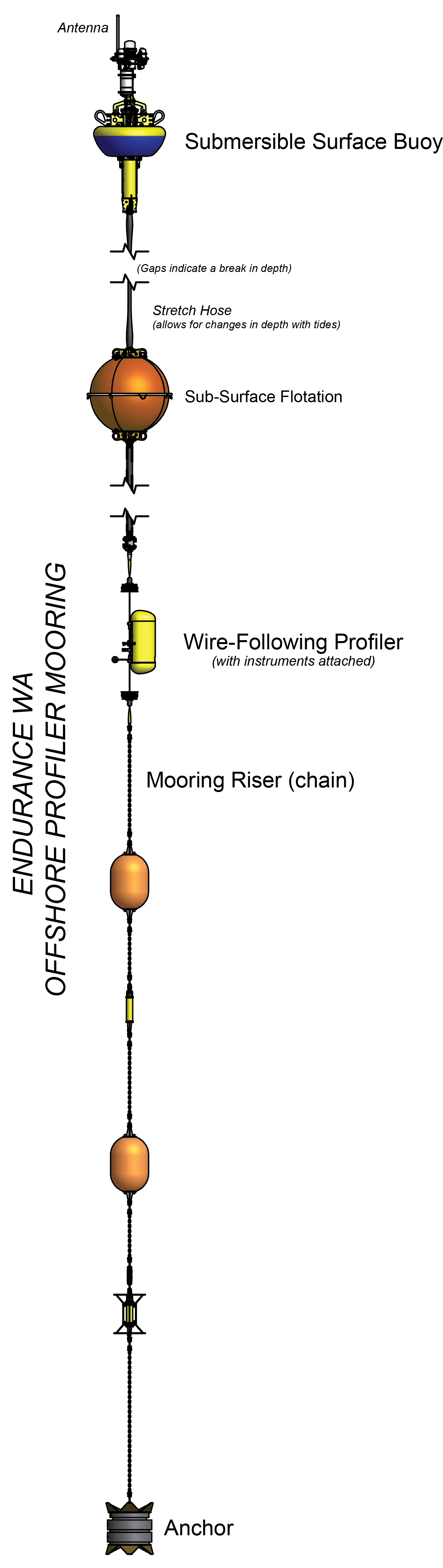
Like other Coastal Profiler Moorings, the Endurance Washington Offshore Profiler Mooring contains a Wire-Following Profiler that houses instruments. The Wire-Following Profiler moves through the water column along the mooring riser, continuously sampling ocean characteristics over a specified depth interval (15 meters below sea surface to 3 m above the bottom).
Instruments
This site/platform includes the following instruments. To learn more about an instrument type, select the instrument class-series. To access relevant data streams for an instrument, the instrument code will take you to the OOI Data Portal.
| Instrument Code | Depth | Node | Instrument Class-Series |
Make & Model |
|---|---|---|---|---|
| CE09OSPM-SBS01-01-MOPAK0000 | 0m | Surface Buoy | 3-Axis Motion Pack (MOPAK0) | MicroStrain - 3DM-GX3-25 |
| CE09OSPM-WFP01-01-VEL3DK000 | 15 to 540 meters | Wire-Following Profiler | 3-D Single Point Velocity Meter (VEL3DK) | Nortek - Aquadopp II |
| CE09OSPM-WFP01-04-FLORTK000 | 15 to 540 meters | Wire-Following Profiler | 3-Wavelength Fluorometer (FLORTK) | WET Labs - ECO Triplet |
| CE09OSPM-WFP01-03-CTDPFK000 | 15 to 540 meters | Wire-Following Profiler | CTD (CTDPFK) | Sea-Bird - SBE 52MP |
| CE09OSPM-WFP01-02-DOFSTK000 | 15 to 540 meters | Wire-Following Profiler | Dissolved Oxygen (DOFSTK) | Sea-Bird - SBE 43F |
| CE09OSPM-WFP01-05-PARADK000 | 15 to 540 meters | Wire-Following Profiler | Photosynthetically Active Radiation (PARADK) | Biospherical Instruments - QSP-2200 |
| CE09OSPM-SBS01-00-STCENG000 | 0m | Surface Buoy | Platform Controller (STCENG) | WHOI - Sensor and Telemetry Controller |
| CE09OSPM-WFP01-00-WFPENG000 | 15 to 540 meters | Wire-Following Profiler | Profiler Controller (WFPENG) | McLane - MMP |
Equipment Diagram
Water Depth
544 meters
Location
46.8517°N, 124.982°W