
Upstream Offshore Profiler Mooring (CP02PMUO)
The Coastal Pioneer New England Shelf Upstream Offshore Profiler Mooring is located on the Continental Slope (approximately 450 m deep), east (i.e., upstream) of the other Moorings. The Continental Shelf-Slope area off the New England coast is a highly productive area and one that is located at a dynamic intersection where ocean currents meet in weather-like “fronts,” and where nutrients, pollutants, and other properties are exchanged between the coast and the deep ocean.
Platform DOI and Citation Guidance
OOI assigns Digital Object Identifiers (DOIs) at the platform or site level. The DOI for the Coastal Pioneer New England Shelf Upstream Offshore Profiler Mooring is 10.58046/OOI-CP02PMUO.
The minimum recommended citation for this platform is:
NSF Ocean Observatories Initiative. (2013). Coastal Pioneer New England Shelf Upstream Offshore Profiler Mooring, DOI: 10.58046/OOI-CP02PMUO.
This follows the format NSF Ocean Observatories Initiative. (Year Published). Platform Title, DOI: Platform DOI, where Year Published is the year OOI data collection began at the site.
We encourage data users to incorporate full citations when referencing OOI data in order to support FAIR data principles and data traceability. OOI also provides further guidance on citations, including information on adding specific data products and data access points to citations.
Data Access
The following links provide data access via Data Explorer or other methods:
- Direct access to the data on this platform and its subcomponents
- General access to OOI data using a variety of methods
Platform Description
The Pioneer NES Upstream Offshore Profiler Mooring is located on the Continental Slope (approximately 450 m deep), east (i.e., upstream) of the other Moorings. The Continental Shelf-Slope area off the New England coast is a highly productive area and one that is located at a dynamic intersection where ocean currents meet in weather-like “fronts,” and where nutrients, pollutants, and other properties are exchanged between the coast and the deep ocean. Data from the offshore slope area help to examine exchanges between the shelf and slope and the shelf ecosystem, as well as provide broader insight into the issues of air-sea gas exchange, including Carbon Dioxide.
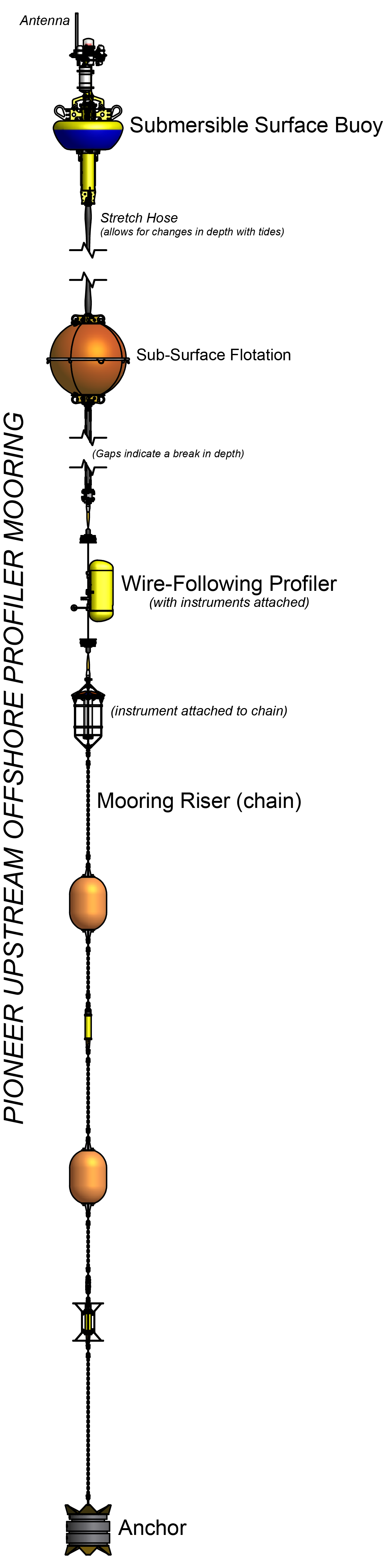
Like other Coastal Profiler Moorings, the Pioneer NES Upstream Offshore Profiler Mooring contains a Wire-Following Profiler that houses instruments. The Wire-Following Profiler moves through the water column along the mooring riser, continuously sampling ocean characteristics over a specified depth interval.
This site was suspended on: 11/22/2022.
Instruments
This site/platform includes the following instruments. To learn more about an instrument type, select the instrument class-series. To access relevant data streams for an instrument, the instrument code will take you to the OOI Data Portal.
| Instrument Code | Depth | Node | Instrument Class-Series |
Make & Model |
|---|---|---|---|---|
| CP02PMUO-SBS01-01-MOPAK0000 | 0m | Surface Buoy | 3-Axis Motion Pack (MOPAK0) | MicroStrain - 3DM-GX3-25 |
| CP02PMUO-WFP01-01-VEL3DK000 | 15 to 425 meters | Wire-Following Profiler | 3-D Single Point Velocity Meter (VEL3DK) | Nortek - Aquadopp II |
| CP02PMUO-WFP01-04-FLORTK000 | 15 to 425 meters | Wire-Following Profiler | 3-Wavelength Fluorometer (FLORTK) | WET Labs - ECO Triplet |
| CP02PMUO-WFP01-03-CTDPFK000 | 15 to 425 meters | Wire-Following Profiler | CTD (CTDPFK) | Sea-Bird - SBE 52MP |
| CP02PMUO-WFP01-02-DOFSTK000 | 15 to 425 meters | Wire-Following Profiler | Dissolved Oxygen (DOFSTK) | Sea-Bird - SBE 43F |
| CP02PMUO-WFP01-05-PARADK000 | 15 to 425 meters | Wire-Following Profiler | Photosynthetically Active Radiation (PARADK) | Biospherical Instruments - QSP-2200 |
| CP02PMUO-SBS01-00-STCENG000 | 0m | Surface Buoy | Platform Controller (STCENG) | WHOI - Sensor and Telemetry Controller |
| CP02PMUO-WFP01-00-WFPENG000 | 15 to 425 meters | Wire-Following Profiler | Profiler Controller (WFPENG) | McLane - MMP |
| CP02PMUO-RII01-02-ADCPSL010 | 15 to 425 meters | Mooring Riser | Velocity Profiler (75 kHz) (ADCPSL) | Teledyne RDI - WorkHorse LongRanger Sentinel 75khz - inductive |
Equipment Diagram
Water Depth
452 meters
Location
39.9394°N, 70.7708°W