
Inshore Surface Mooring (CP03ISSM)
The Coastal Pioneer New England Shelf Inshore Surface Mooring is located on the inner Continental Shelf, approximately 90 meters deep. The Continental Shelf-Slope area off the New England coast is a highly productive area and one that is located at a dynamic intersection where ocean currents meet in weather-like “fronts,” and where nutrients, pollutants, and other properties are exchanged between the coast and the deep ocean.
Platform DOI and Citation Guidance
OOI assigns Digital Object Identifiers (DOIs) at the platform or site level. The DOI for the Coastal Pioneer New England Shelf Inshore Surface Mooring is 10.58046/OOI-CP03ISSM.
The minimum recommended citation for this platform is:
NSF Ocean Observatories Initiative. (2014). Coastal Pioneer New England Shelf Inshore Surface Mooring, DOI: 10.58046/OOI-CP03ISSM.
This follows the format NSF Ocean Observatories Initiative. (Year Published). Platform title, DOI: Platform DOI, where Year Published is the year OOI data collection began at the site.
We encourage data users to incorporate full citations when referencing OOI data in order to support FAIR data principles and data traceability. OOI also provides further guidance on citations, including information on adding specific data products and data access points to citations.
Data Access
The following links provide data access via Data Explorer or other methods:
- Direct access to the data on this platform and its subcomponents
- General access to OOI data using a variety of methods
Platform Description
The Pioneer NES Inshore Surface Mooring is located on the inner Continental Shelf, approximately 90 meters deep. The Continental Shelf-Slope area off the New England coast is a highly productive area and one that is located at a dynamic intersection where ocean currents meet in weather-like “fronts,” and where nutrients, pollutants, and other properties are exchanged between the coast and the deep ocean. Data from the inshore, shelf area help to examine exchanges between the shelf and slope and the shelf ecosystem, as well as provide broader insight into the issues of air-sea gas exchange, including Carbon Dioxide.
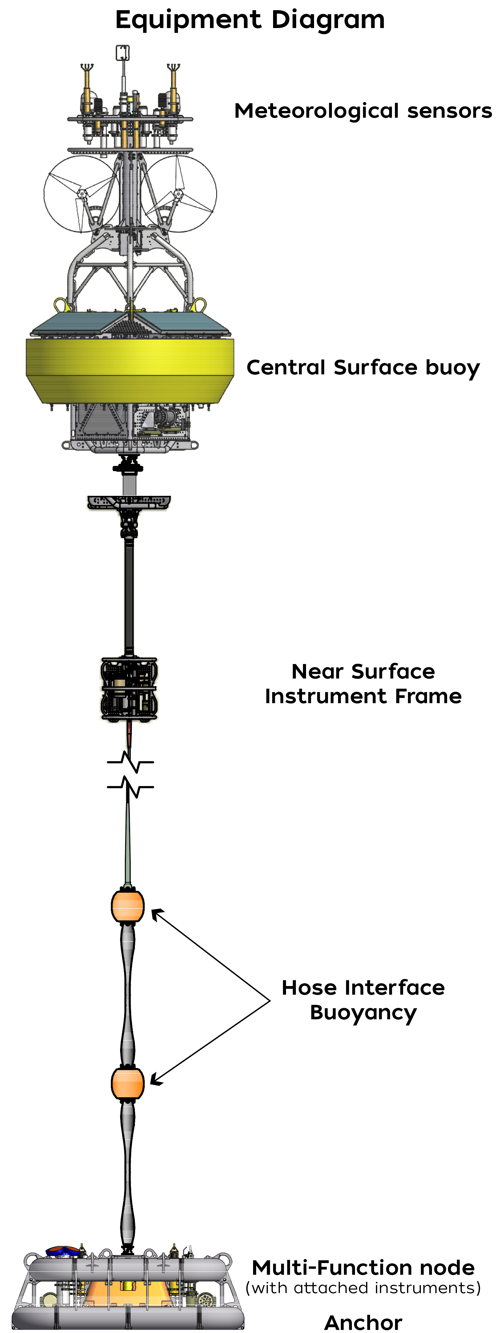
Like other Coastal Surface Moorings, the Pioneer NES Inshore Surface Mooring is specifically designed to examine coastal-scale phenomena and withstand the challenging conditions of shallow coastal environments, including large tidal fluctuations. The Surface Mooring contains instruments attached to a Surface Buoy floating on the sea surface, Near Surface Instrument Frame 7 meters below the surface, and a Seafloor Multi-Function Node (MFN) located on the seafloor. The Surface Buoy provides a platform on which to secure surface instruments above the sea surface, below the sea surface, and across the interface between. Additionally the Surface Buoy contains an antenna to transmit data to shore via satellite.
This site was suspended on: 11/22/2022.
Deployment Photos
-
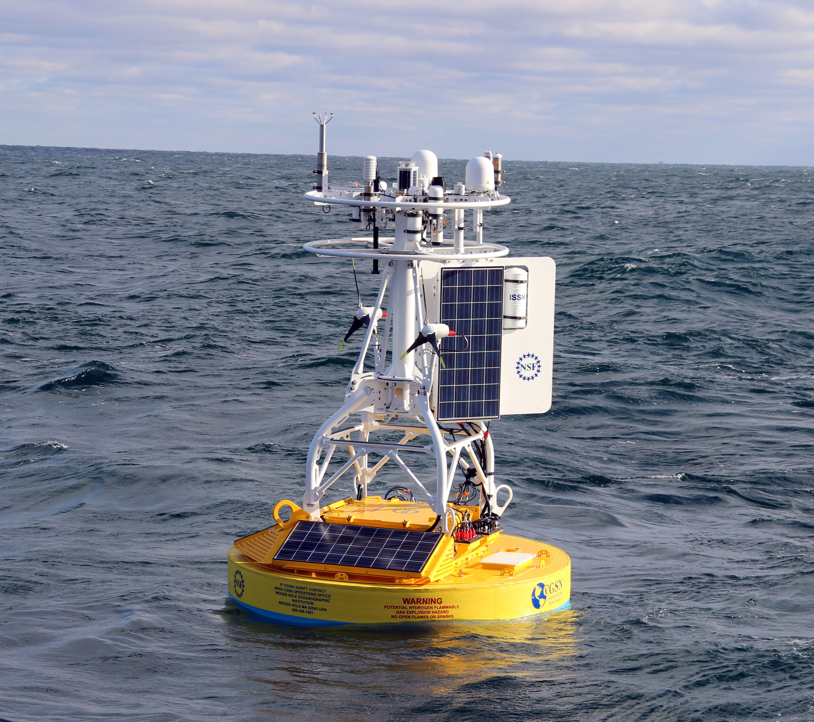
- The Pioneer Array Inshore Surface Mooring (ISSM) at sea just after deployment from the R/V Knorr on 14 December 2014. Credit: Al Plueddemann, WHOI/CGSN
Instruments
This site/platform includes the following instruments. To learn more about an instrument type, select the instrument class-series. To access relevant data streams for an instrument, the instrument code will take you to the OOI Data Portal.
| Instrument Code | Depth | Node | Instrument Class-Series |
Make & Model |
|---|---|---|---|---|
| CP03ISSM-SBD11-01-MOPAK0000 | 0m | Surface Buoy | 3-Axis Motion Pack (MOPAK0) | MicroStrain - 3DM-GX3-25 |
| CP03ISSM-RID27-02-FLORTD000 | 7m | Near Surface Instrument Frame | 3-Wavelength Fluorometer (FLORTD) | WET Labs - ECO Triplet-w |
| CP03ISSM-MFD37-07-ZPLSCC000 | 92m | Seafloor Multi-Function Node (MFN) | Bio-acoustic Sonar (Coastal) (ZPLSCC) | ASL Environmental Sciences - AZFP |
| CP03ISSM-SBD11-06-METBKA000 | -3m | Surface Buoy | Bulk Meteorology Instrument Package (METBKA) | Star Engineering - ASIMET |
| CP03ISSM-RID27-03-CTDBPC000 | 7m | Near Surface Instrument Frame | CTD (CTDBPC) | Sea-Bird - SBE 16plusV2 |
| CP03ISSM-MFD37-03-CTDBPD000 | 92m | Seafloor Multi-Function Node (MFN) | CTD (CTDBPD) | Sea-Bird - SBE 16plusV2 |
| CP03ISSM-SBD11-00-DCLENG000 | 0m | Surface Buoy | Data Concentrator Logger (DCLENG) | WHOI - Data Concentrator Logger |
| CP03ISSM-SBD12-00-DCLENG000 | 0m | Surface Buoy | Data Concentrator Logger (DCLENG) | WHOI - Data Concentrator Logger |
| CP03ISSM-RID26-00-DCLENG000 | 7m | Near Surface Instrument Frame | Data Concentrator Logger (DCLENG) | WHOI - Data Concentrator Logger |
| CP03ISSM-RID27-00-DCLENG000 | 7m | Near Surface Instrument Frame | Data Concentrator Logger (DCLENG) | WHOI - Data Concentrator Logger |
| CP03ISSM-MFD35-00-DCLENG000 | 92m | Seafloor Multi-Function Node (MFN) | Data Concentrator Logger (DCLENG) | WHOI - Data Concentrator Logger |
| CP03ISSM-MFD37-00-DCLENG000 | 92m | Seafloor Multi-Function Node (MFN) | Data Concentrator Logger (DCLENG) | WHOI - Data Concentrator Logger |
| CP03ISSM-RID27-04-DOSTAD000 | 7m | Near Surface Instrument Frame | Dissolved Oxygen (DOSTAD) | Aanderaa - Optode 4831 |
| CP03ISSM-MFD37-04-DOSTAD000 | 92m | Seafloor Multi-Function Node (MFN) | Dissolved Oxygen (DOSTAD) | Aanderaa - Optode 4831 |
| CP03ISSM-SBD11-02-HYDGN0000 | 0m | Surface Buoy | Hydrogen Sensor (HYDGN0) | RKI Instruments - M2A transmitters |
| CP03ISSM-SBD12-03-HYDGN0000 | 0m | Surface Buoy | Hydrogen Sensor (HYDGN0) | RKI Instruments - M2A transmitters |
| CP03ISSM-RID26-07-NUTNRB000 | 7m | Near Surface Instrument Frame | Nitrate (NUTNRB) | Sea-Bird - SUNA V2 |
| CP03ISSM-SBD12-04-PCO2AA000 | 0m | Surface Buoy | pCO2 Air-Sea (PCO2AA) | Pro-Oceanus - pCO2-pro |
| CP03ISSM-MFD35-05-PCO2WB000 | 92m | Seafloor Multi-Function Node (MFN) | pCO2 Water (PCO2WB) | Sunburst - SAMI-pCO2 |
| CP03ISSM-SBC11-00-CPMENG000 | 0m | Surface Buoy | Platform Controller (CPMENG) | WHOI - Communications and Power Manager |
| CP03ISSM-RIC21-00-CPMENG000 | 7m | Near Surface Instrument Frame | Platform Controller (CPMENG) | WHOI - Communications and Power Manager |
| CP03ISSM-MFC31-00-CPMENG000 | 92m | Seafloor Multi-Function Node (MFN) | Platform Controller (CPMENG) | WHOI - Communications and Power Manager |
| CP03ISSM-MFD35-02-PRESFB000 | 92m | Seafloor Multi-Function Node (MFN) | Seafloor Pressure (PRESFB) | Sea-Bird - SBE 26plus |
| CP03ISSM-RID26-06-PHSEND000 | 7m | Near Surface Instrument Frame | Seawater pH (PHSEND) | Sunburst - SAMI-pH |
| CP03ISSM-MFD35-06-PHSEND000 | 92m | Seafloor Multi-Function Node (MFN) | Seawater pH (PHSEND) | Sunburst - SAMI-pH |
| CP03ISSM-RID26-04-VELPTA000 | 7m | Near Surface Instrument Frame | Single Point Velocity Meter (VELPTA) | Nortek - Aquadopp 300m |
| CP03ISSM-MFD35-04-VELPTA000 | 92m | Seafloor Multi-Function Node (MFN) | Single Point Velocity Meter (VELPTA) | Nortek - Aquadopp 300m |
| CP03ISSM-RID26-08-SPKIRB000 | 7m | Near Surface Instrument Frame | Spectral Irradiance (SPKIRB) | Satlantic - OCR507 ICSW |
| CP03ISSM-RID27-01-OPTAAD000 | 7m | Near Surface Instrument Frame | Spectrophotometer (OPTAAD) | WET Labs - AC-S |
| CP03ISSM-MFD37-01-OPTAAD000 | 92m | Seafloor Multi-Function Node (MFN) | Spectrophotometer (OPTAAD) | WET Labs - AC-S |
| CP03ISSM-MFD35-01-ADCPTF000 | 92m | Seafloor Multi-Function Node (MFN) | Velocity Profiler (150kHz) (ADCPTF) | Teledyne RDI - WorkHorse Sentinel 150khz |
Equipment Diagram
Water Depth
92 meters
Location
40.3619°N, 70.8783°W