
Mobile Assets (CP05MOAS)
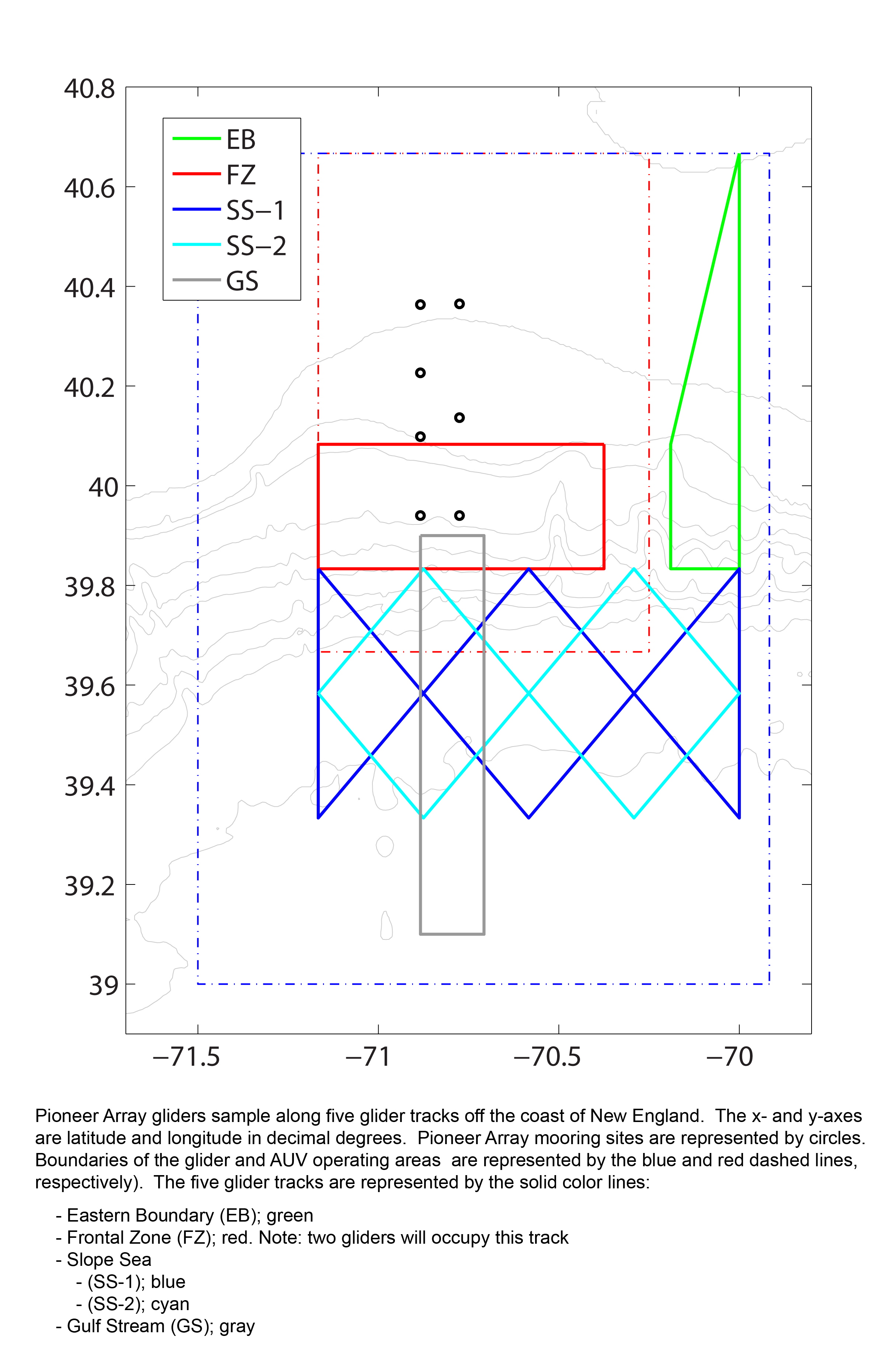
The Coastal Pioneer New England Shelf Mobile Assets are an array of 6 Coastal Gliders (Teledyne-Webb Slocum Gliders) that sample large, mesoscale features through a broad region (130 x 185 km) of the outer continental shelf between the shelf break and the Gulf Stream. The role of these gliders in monitoring this broader area is to resolve rings, eddies and meanders from the Gulf Stream as they impinge on the shelf break front.
Platform DOI and Citation Guidance
OOI assigns Digital Object Identifiers (DOIs) at the platform or site level. The DOI for the Coastal Pioneer New England Shelf Mobile Assets is 10.58046/OOI-CP05MOAS.
The minimum recommended citation for this platform is:
NSF Ocean Observatories Initiative. (2014). Coastal Pioneer New England Shelf Mobile Assets, DOI: 10.58046/OOI-CP05MOAS.
This follows the format NSF Ocean Observatories Initiative. (Year Published). Platform title, DOI: Platform DOI, where Year Published is the year OOI data collection began at the site.
We encourage data users to incorporate full citations when referencing OOI data in order to support FAIR data principles and data traceability. OOI also provides further guidance on citations, including information on adding specific data products and data access points to citations.
Data Access
The following links provide data access via Data Explorer or other methods:
- Direct access to the data on this platform and its subcomponents
- General access to OOI data using a variety of methods
Platform Description
Two kinds of Mobile Assets survey the area in and around the array of moorings at the Coastal Pioneer NES Array – Coastal Gliders and Coastal Autonomous Underwater Vehicles (AUVs).
Approximate Glider sampling area boundaries:
SE: 39.00°N, 69.92°W
SW: 39.00°N, 71.50°W
NW: 40.67°N, 71.50°W
NE: 40.67°N, 69.92°W
Approximate AUV sampling area boundaries:
SE: 39.67°N, 70.25°W
SW: 39.67°N, 71.17°W
NW: 40.67°N, 71.17°W
NE: 40.67°N, 70.25°W
An array of 6 Coastal Gliders (Teledyne-Webb Slocum Gliders) sample large, mesoscale features through a broad region (130 x 185 km) of the outer continental shelf between the shelf break and the Gulf Stream. The role of these gliders in monitoring this broader area is to resolve rings, eddies and meanders from the Gulf Stream as they impinge on the shelf break front. These Teledyne-Webb Slocum Gliders fly through the water column along saw-tooth paths, penetrating the sea surface and diving down to a maximum depth of 1000 meters.
An array of two Coastal AUVs (REMUS-600 AUVs) travel along transects across the shelf-break frontal system extending beyond the mooring array, covering an area approximately 80 x 100 km in size centered on the array of moorings. The primary role of the AUVs is to resolve cross- and along-front “eddy fluxes” due to frontal instabilities, wind forcing, and mesoscale variability. These AUVs travel along saw-toothed transects, penetrating the sea surface and diving down to a maximum depth of 600 meters.
This site was suspended on: 11/22/2022.
Deployment Photos
Instruments
This site/platform includes the following instruments. To learn more about an instrument type, select the instrument class-series. To access relevant data streams for an instrument, the instrument code will take you to the OOI Data Portal.
| Instrument Code | Depth | Node | Instrument Class-Series |
Make & Model |
|---|---|---|---|---|
| CP05MOAS-PGnnn-03-FLORTM000 | 0 to 200 meters | Global Profiling Glider nnn | 3-Wavelength Fluorometer (FLORTM) | WET Labs - ECO Puck FLBBCD-SLK |
| CP05MOAS-PGnnn-04-FLORTO000 | 0 to 200 meters | Global Profiling Glider nnn | 3-Wavelength Fluorometer (FLORTO) | WET Labs - ECO BB3 |
| CP05MOAS-Annnn-01-FLORTN000 | 0 to 600 meters | Coastal AUV nnnn | 3-Wavelength Fluorometer (FLORTN) | WET Labs - ECO Triplet |
| CP05MOAS-GLnnn-02-FLORTM000 | 0 to 1,000 meters | Coastal Glider nnn | 3-Wavelength Fluorometer (FLORTM) | WET Labs - ECO Puck FLBBCD-SLK |
| CP05MOAS-PGnnn-01-CTDGVM000 | 0 to 200 meters | Global Profiling Glider nnn | CTD (CTDGVM) | Sea-Bird - SBE Glider Payload CTD (GP-CTD) |
| CP05MOAS-Annnn-03-CTDAVN000 | 0 to 600 meters | Coastal AUV nnnn | CTD (CTDAVN) | Sea-Bird - SBE Glider Payload CTD (GP-CTD) |
| CP05MOAS-GLnnn-03-CTDGVM000 | 0 to 1,000 meters | Coastal Glider nnn | CTD (CTDGVM) | Sea-Bird - SBE Glider Payload CTD (GP-CTD) |
| CP05MOAS-PGnnn-02-DOSTAM000 | 0 to 200 meters | Global Profiling Glider nnn | Dissolved Oxygen (DOSTAM) | Aanderaa - Optode 4831 |
| CP05MOAS-Annnn-02-DOSTAN000 | 0 to 600 meters | Coastal AUV nnnn | Dissolved Oxygen (DOSTAN) | Aanderaa - Optode 4330 |
| CP05MOAS-GLnnn-04-DOSTAM000 | 0 to 1,000 meters | Coastal Glider nnn | Dissolved Oxygen (DOSTAM) | Aanderaa - Optode 4831 |
| CP05MOAS-PGnnn-00-ENG000000 | 0 to 200 meters | Global Profiling Glider nnn | Mobile Asset Controller (ENG000) | Teledyne Webb - G2 Slocum Gliders |
| CP05MOAS-Annnn-00-ENG000000 | 0 to 600 meters | Coastal AUV nnnn | Mobile Asset Controller (ENG000) | Teledyne Webb - G2 Slocum Gliders |
| CP05MOAS-GLnnn-00-ENG000000 | 0 to 1,000 meters | Coastal Glider nnn | Mobile Asset Controller (ENG000) | Teledyne Webb - G2 Slocum Gliders |
| CP05MOAS-PGnnn-05-NUTNRM000 | 0 to 200 meters | Global Profiling Glider nnn | Nitrate (NUTNRM) | Sea-Bird - SUNA V2 |
| CP05MOAS-Annnn-04-NUTNRN000 | 0 to 600 meters | Coastal AUV nnnn | Nitrate (NUTNRN) | Sea-Bird - Deep SUNA |
| CP05MOAS-PGnnn-06-PARADM000 | 0 to 200 meters | Global Profiling Glider nnn | Photosynthetically Active Radiation (PARADM) | Biospherical Instruments - QSP-2155 |
| CP05MOAS-Annnn-06-PARADN000 | 0 to 600 meters | Coastal AUV nnnn | Photosynthetically Active Radiation (PARADN) | Biospherical Instruments - QSP-2150 |
| CP05MOAS-GLnnn-05-PARADM000 | 0 to 1,000 meters | Coastal Glider nnn | Photosynthetically Active Radiation (PARADM) | Biospherical Instruments - QSP-2155 |
| CP05MOAS-Annnn-05-ADCPAN000 | 0 to 600 meters | Coastal AUV nnnn | Velocity Profiler (600kHz) (ADCPAN) | Teledyne RDI - Workhorse Navigator 600 kHz dual |
| CP05MOAS-GLnnn-01-ADCPAM000 | 0 to 1,000 meters | Coastal Glider nnn | Velocity Profiler (600kHz) (ADCPA) | Teledyne RDI - Explorer DVL 600 kHz |
Equipment Diagram
Water Depth
1000 meters
Location
39.83°N, 70.71°W