
Exploring the Coastal Surface Piercing Profiler (CSPP): Capabilities, Challenges & Impact
The Coastal Surface Piercing Profiler (CSPP) is an important component of the Ocean Observatories Initiative (OOI), uniquely designed to collect high-resolution data from the ocean’s surface to the seafloor over the Oregon Shelf. Importantly, as the name implies, the CSPP does not stop at the ocean surface but some of its sensors actually pierces the interface into the near surface atmosphere. Operating in a highly dynamic environment, the CSPP provides valuable datasets that enhance our understanding of ocean-atmosphere interactions, nearshore processes, and biological activity in the upper water column.
In this interview, Jon Fram, co-PI and Program Manager for the Endurance Array (EA), explores the technical capabilities of the CSPP, the difficulties of operating in dynamic coastal conditions, and the significance of its unique datasets. With its ability to profile up through the air-sea interface and its collection of advanced sensors, the CSPP bridges critical gaps in ocean observation. Jon discusses the practical realities of deploying and maintaining the profiler, including a notable recovery effort that illustrates the complexity of coastal oceanographic work.
How does the CSPP operate in such a dynamic environment, and what are some of the challenges associated with deploying and maintaining it?
In between profiles, CSPPs park near the seafloor where currents from waves and tides are relatively calm. As CSPPs winch themselves up to the air-sea interface, they measure winchline tension and they alter their profiling speed to keep the tension constant. This behavior enables CSPPs to surface when waves are up to 3 meters high without the winchline over-wrapping or experiencing snap loads. We monitor conditions so CSPPs don’t profile when seas are too rough. Most of a CSPP’s battery energy goes to operating its winch, so CSPPs need to be recovered/redeployed every 2-3 months and they are limited to 2-4 profiler per day during each deployment (when conditions are sufficiently calm).
What types of sensors and instruments are on the profiler, and what specific data do they collect?
CSPPs average 25 cm/s as they profile upwards. Their CTDs sample at 16 Hz, which corresponds to a measurement every 1.5 cm. Their ~1 Hz instruments include dissolved oxygen (DOSTA), point velocity (VELPT), nitrate (NUTNR), spectral irradiance (SPKIR), photosynthetically active radiation (PARAD), and chlorophyll-a—optical backscatter—CDOM (FLORT). The CSPP is a particularly useful platform for the optical attenuation and absorption instrument (OPTAA), which can be used to characterize phytoplankton communities at the top of the water column.
What are the unique capabilities of the CSPP, and how do its datasets differ from those collected by other platforms within the OOI?
The CSPP is OOI’s only profiler that samples up to the air-sea interface.
How has the profiler contributed to understanding the relationship between atmospheric and oceanic processes in the area?
So far, OOI’s CSPPs have been used to fill in time gaps in mooring data and to fill in spatial gaps between mooring near-surface (NSIF) and benthic (MFN) data. Inshore and shelf CSPP data have been used together to calculate cross-shore exchange of nitrate, which is increased each spring due to coastal upwelling. CSPPs measure at the air-sea surface, so their measurements could be used to validate satellite data.
How could the near-time data transmission from the profiler benefit research efforts or inform stakeholders such as fisheries, conservation groups, or local communities?
Datasets are available within a week after each deployment. They can telemeter all data when they are on the surface at the top of each profile, however, we transfer only data needed for operational decisions to reduce the chance of winchline fouling.
Can you share an anecdote about a particularly challenging or rewarding moment during the deployment, maintenance, or operation of the profiler?
One challenging moment occurred 06 April 2019. During a storm, rough seas (~7m significant wave height, >1 m/s currents) dislodged our 25m depth Oregon Inshore CSPP and deposited it 75 nm north on a pocket beach in Ecola State Park. We climbed down to it, pulled it above the high tide line, disassembled it, and packed it out piece-by-piece up a steep trail in pouring rain. The Endurance Array inshore CSPP and adjacent surface mooring measure the northward fresh/turbid surface current that hugs the Pacific Northwest coast during winter, and which strengthens during storms. This is one example of how the CSPP data can be used to improve our wind, wave and current forecast models.
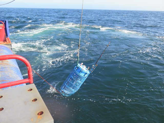
Deployment of CSPP. (c) Jon Fram
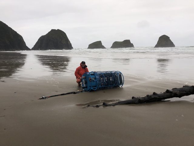
Beach recovery effort. Pictured: Ian Black, OSU. (c): Jon Fram
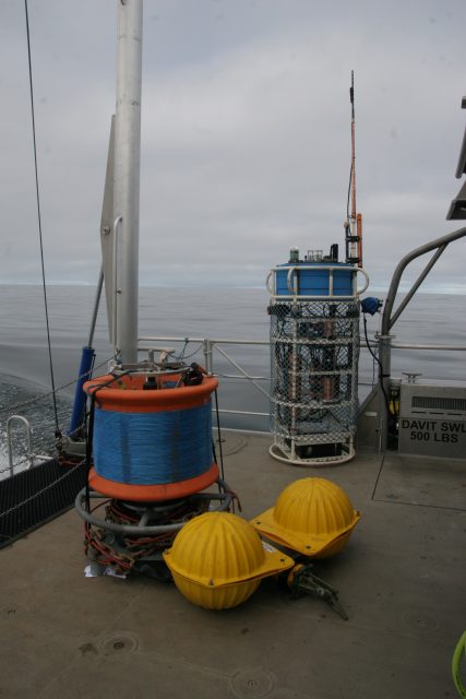
The deck of a ship. The profiler is sitting next to its anchor. The anchor system was recently redesigned to improve reliability. (c): Jon Fram