
Scaling Up Discovery: A Machine Learning–Assisted Framework for Rapid Annotation of Benthic Megafauna in Marine Imagery
Methane hydrate-based ecosystems are amazingly abundant along the ~1000 km-long Cascadia Margin, from Cape Mendocino in Northern California to the northern tip of Vancouver Island. Here, 3,500 methane bubble streams, clustered into more than 1,300 emission sites, have been documented. These sediment-dominated environments, underlain by tonnes of methane hydrate, host robust and diverse microbial communities and are “hot spots” of megafauna. Yet only three sites have been investigated in detail. One is the Regional Cabled Array (RCA) Southern Hydrate Ridge (SHR) site, designated as essential fish habitat. A suite of instruments operates at SHR to understand how these important and dynamic ecosystems respond as shallow hydrate breaks down in response to seismic events, bottom-water warming, and seasonal to decadal change. Among them is a digital still camera focused on the most active emission site, “Einstein’s Grotto.” For over a decade, the camera has streamed 3 images every half hour, 24/7, to shore.
A critical bottleneck in converting the enormous image archive at SHR into reliable ecological data has been the labor-intensive manual identification and annotation of organisms. In “A Machine Learning Assisted Method for Rapidly Annotating Benthic Megafauna in Large Volumes of Marine Imagery,” Bigham and Carter (2026) show how AI, combined with human expertise, can break this bottleneck. Their iterative workflow pairs model predictions with expert validation, correction of misidentified organisms, and retraining to progressively improve performance.
The results highlight how powerful this approach can be. The workflow generated 92,153 annotations across 50,840 images and 10 morphological taxonomic groups in just six weeks. Doing this by hand would have taken approximately 5.9 years. Expert review remained essential for correcting false detections and classification errors, and for recognizing the model’s limits in complex underwater settings.
This study provides a practical, expandable framework for transforming continuous marine imagery into ecological time series that track changes in abundance, community composition, and ecosystem dynamics. With local training and validation, it could serve other habitats, imaging platforms, and long-term observing programs. This work highlights the significant discovery opportunities when RCA’s high-density, continuous data streams are paired with AI and human expertise. It offers a scalable pathway toward more timely, reproducible, and data-rich assessments of deep-sea ecosystems, strengthening our ability to detect ecological change in a rapidly changing ocean.
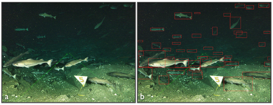
Example digital still image from the cabled camera at the Regional Cabled Array methane seep site Einstein’s Grotto, Southern Hydrate Ridge. a) Schools of black cod forage above the sedimented seafloor in this nutrient rich environment. Clam shell chaff collects in depressions. b) Annotated image using a human-in-the-loop workflow built around YOLO. A detector trained on manually annotated imagery ran inference over the full image set and wrote YOLO text files with predicted classes and bounding boxes.
___________________
Reference: Bigham, K.T., and Carter, A (2026) A machine learning assisted method for rapidly annotating benthic megafauna in large volumes of marine imagery. Limnology and Oceanography: Methods. doi: 10.1002/lom3.70057.