
Successful Underwater Surveys in the Mid-Atlantic Bight: OOI Team Deploys REMUS AUVs for Coastal Ocean Monitoring
Taking advantage of a period of calm weather, OOI staff successfully completed underwater surveys of the Pioneer Mid-Atlantic Bight (MAB) shelf and upper slope using OOI REMUS AUVs. With ab underway speed of over 3 knots, the AUVs provide synoptic transects of rapidly changing coastal systems – analogous to repeated “snapshots” of the ocean physical, biological, and nutrient conditions across the shelf capturing changes that occur over short time and spatial scales (meters to kilometers, and hours to one day).
The OOI Pioneer array was relocated from the New England Shelf (NES) to the southern Mid-Atlantic Bight in April 2024. AUV surveys previously conducted in the continental shelf waters offshore of New England now take place offshore of the sandy Outer Banks of North Carolina in a new and highly dynamic part of the US continental shelf. Moving the Pioneer Array to the MAB naturally resulted in some changes to operations, foremost being the use of new vessels (for this cruise, the R/V Virginia operated by the Virginia Institute of Marine Science). For efficiency, the AUVs are shipped fully assembled inside a 20 ft shipping container, along with all communications, control, and deck equipment. On arrival everything can be hoisted aboard and prepared for sea without needing re-integration that consumes valuable days on shore (Fig 1). The ships crane was modified by WHOI engineer Jared Schwartz to install the Ship of Opportunity Launch and Recovery System (SOO-LARS), a modular hydraulic winch system that OOI employs for safe and efficient deployment and recovery of these large AUVs on ships of several classes (Fig. 2).
The AUV operations at MAB derive from previous work at Pioneer NES. Once deployed, the AUVs run autonomously and sample in a series of saw-tooth profiles along a pre-programmed track, remaining in acoustic contact with the support vessel and surfacing periodically to update exact location from GPS. These plans were adapted for the MAB to compensate for the larger expanse of shelf traversed and the large changes in water column density between the shallow (25 m) inner shelf and deeper > 500 m upper slope. This is further complicated by density variations along the shelf and seasonally under the triple-influence of estuarine outflows, continental shelf processes, and the Gulf Stream just a few miles beyond the offshore extent of the sampling region (Fig 3). The MAB is also busy with a range of commercial, fishing, and military vessel traffic, offshore fixed installations, and ocean life in every shape and size imaginable. All factors that must be considered in advance and avoided underway by the invisible submerged AUVs. As was true for Pioneer NES, the support and knowledge of local vessel operators is vital to supporting at-sea operations and for meeting OOI’s science mission objectives.
The AUV data were offloaded from the vehicles after recovery. The data are discoverable in the OOI Data Explorer, and also available on the OOI raw data repository, following data format conversion and sensor post-calibration.
In addition to completing two consecutive surveys, each about 24 hours in length, the at-sea team of Andy Robinson, Collin Dobson, and Natalia Moore completed the scheduled recovery of the Offshore Mesoscale glider cp_379 (Fig. 4). A bonus accomplishment of this cruise was cross-training OOI staff new to AUV operations (Moore), made easier by the prevailing mild weather, experienced AUV techs, and the capable ship’s crew.
-
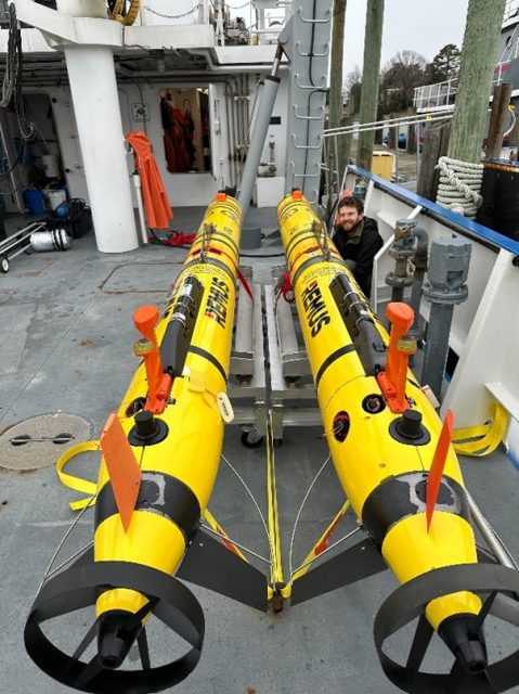
- February: Two OOI REMUS AUVs aboard the RV Virginia
-
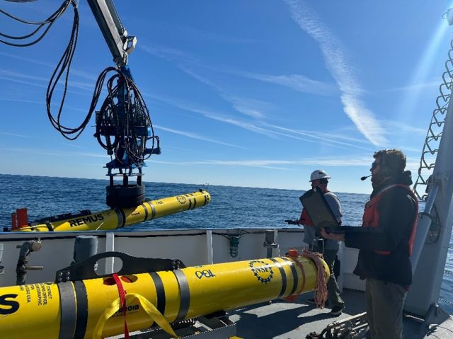
- Figure 2. AUV operations aboard the RV Virginia during February 2025. The custom launch and recovery system was adapted to the Virginia’s crane, allowing for controlled AUV deployments and recoveries.
-
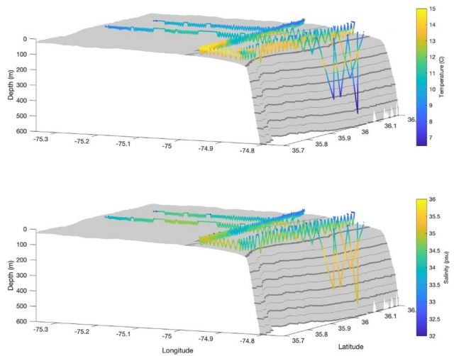
- Figure 3. Spatial maps of CTD temperature and salinity were acquired between Feb 22 -24, 2025 on roughly orthogonal tracks. The Along-shelf (AL) track is parallel to the MAB shelf-break between 80-120 m depth contours and the Across-shelf (AC) track runs from the inner shelf to the upper slope where depth ranges from 25 – 500 m
-
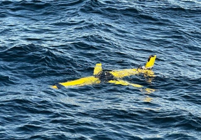
- Figure 4. OOI glider CP 379 just prior to recovery by the RV Virginia.
Photo credits: Collin Dobson