
Help Us Solve a Mystery of the Deep
We would like the community’s help in deciphering an unusual “blow down” event impacting environmental conditions near the flank of Axial Seamount (summit depth ~1500 m), located 300 miles offshore Oregon (Figure 1a). A blow down and its impacts were recorded by numerous instruments streaming data back to shore in real time from the Axial Base Shallow Profiler Mooring. The mooring is one of three two-legged moorings on the RCA that include a mechanical anchored leg and a second anchored leg consisting of an Electrical-Optical-Mechanical (EOM) cable supplying power and two-way communications (anchors at ~ 2600 m). Both legs attach to an ~ 3.7 m across central float at ~ 200 m water depth providing 900 Kg buoyancy that pulls on the legs (Figure 1b). The float contains a static platform hosting 8 instruments and a winched science pod with 10 instruments, that conducts a daily science mission of 9 profiles spanning 200 m to ~ 5 m beneath the surface, depending on overlying seastate (see McRae, 2016). For seven of the profiles, the pod ascends at 5 cm/sec and descends at 10 cm/sec. In total, Two profiles are stepped and include 5-minute stops on descent.
The event started April 8, 2026, lasting until April 12, 2026. It was marked by a staggered increase in pressure (depth) closely related to tides, with a mean current of ~ 30 cm sec toward the NE, which blew the platform down almost 40 meters on April 24th (Figure 1c). The water mass included lower dissolved oxygen concentrations and a decrease in pH. Could this reflect an internal wave with tidal forcing? (M. Muglia, pers comm). Over the 12 years of nearly constant monitoring at Axial Base, this is the first time we have witnessed such an event. Several blowdowns have been documented at the Oregon Slope Base and Offshore Shallow Profiler Moorings, but never with the “sawtooth” changes in pressure.
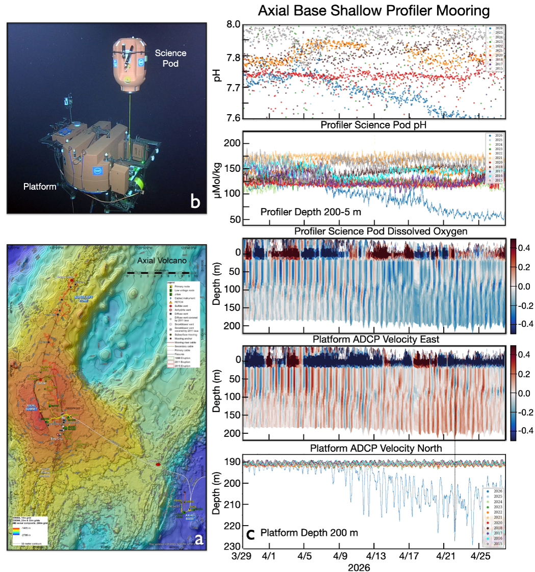
Figure 1. a) Location of the Regional Cabled Array Shallow Profiler Mooring near the base of Axial Seamount (water depth 2600 m), located ~ 300 miles off Oregon. (b) Cabled 2-legged Shallow Profiler Mooring hosting a 12 foot-across platform at 200 m water depth with 1) an array of cabled static instruments (e.g. ADCP, CTD-O2, pH, fluorometer, camera etc); and 2) a winched instrumented profiling “science pod” hosting similar instruments (including CO2, nitrate, PAR etc), which profiles up and down through the water column 9 times a day. c) Platform pressure (depth) and ADCP(m/s) measurements, and winched profiler values for dissolved oxygen concentration and pH.
___________________
Reference:
McRae, E., “Continuous real time scanning of the upper ocean water column. Oceans ,” OCEANS 2016 MTS/IEEE Monterey, Monterey, CA Monterey, USA, 2016, pp. 1-6, doi: 10.1109/OCEANS.2016.7761359.