
Southern Hydrate Summit 2 Seafloor (RS01SUM2)
The Southern Hydrate Summit 2 Seafloor study site, situated on the continental slope off the coast of Oregon at a water depth of ~ 775 m, hosts abundant deposits of methane ice (methane hydrates) that are buried beneath, and sometime exposed at the seafloor.
Platform DOI and Citation Guidance
OOI assigns Digital Object Identifiers (DOIs) at the platform level. The DOI for the Oregon Margin Southern Hydrate Summit 2 Seafloor is 10.58046/OOI-RS01SUM2.
The minimum recommended citation for this platform is:
NSF Ocean Observatories Initiative. (2014). Oregon Margin Southern Hydrate Summit 2 Seafloor, DOI: 10.58046/OOI-RS01SUM2.
This follows the format NSF Ocean Observatories Initiative. (Year Published). Platform title, DOI: Platform DOI, where Year Published is the year OOI data collection began at the platform.
We encourage data users to incorporate full citations when referencing OOI data in order to support FAIR data principles and data traceability. OOI also provides further guidance on citations, including information on adding specific data products and data access points to citations.
Data Access
The following links provide data access via Data Explorer or other methods:
- Direct access to the data on this platform and its subcomponents
- General access to OOI data using a variety of methods
Platform Description
The Southern Hydrate Summit 2 Seafloor study site, situated on the continental slope off the coast of Oregon at a water depth of ~ 775 m, hosts abundant deposits of methane ice (methane hydrates) that are buried beneath, and sometime exposed at the seafloor. The deposits vent methane-rich fluids and bubbles that escape through seeps on the ocean bottom. At Southern Hydrate Ridge plumes of bubbles rise several hundred meters above the seafloor. Dense and fascinating communities of microbes and animals with symbiotic microbes in their guts are fueled by these escaping gases. These seeps provide a unique opportunity to study ocean chemistry, quantifying chemical fluxes from the seafloor and the impacts of methane release on overlying seawater and biota.
Methane is a powerful greenhouse gas and, therefore, quantifying the flux of methane from the seafloor into the hydrosphere is critical to understanding carbon-cycle dynamics and the impacts of global warming on methane release, particularly in the context of the hydrates response to seismic events.
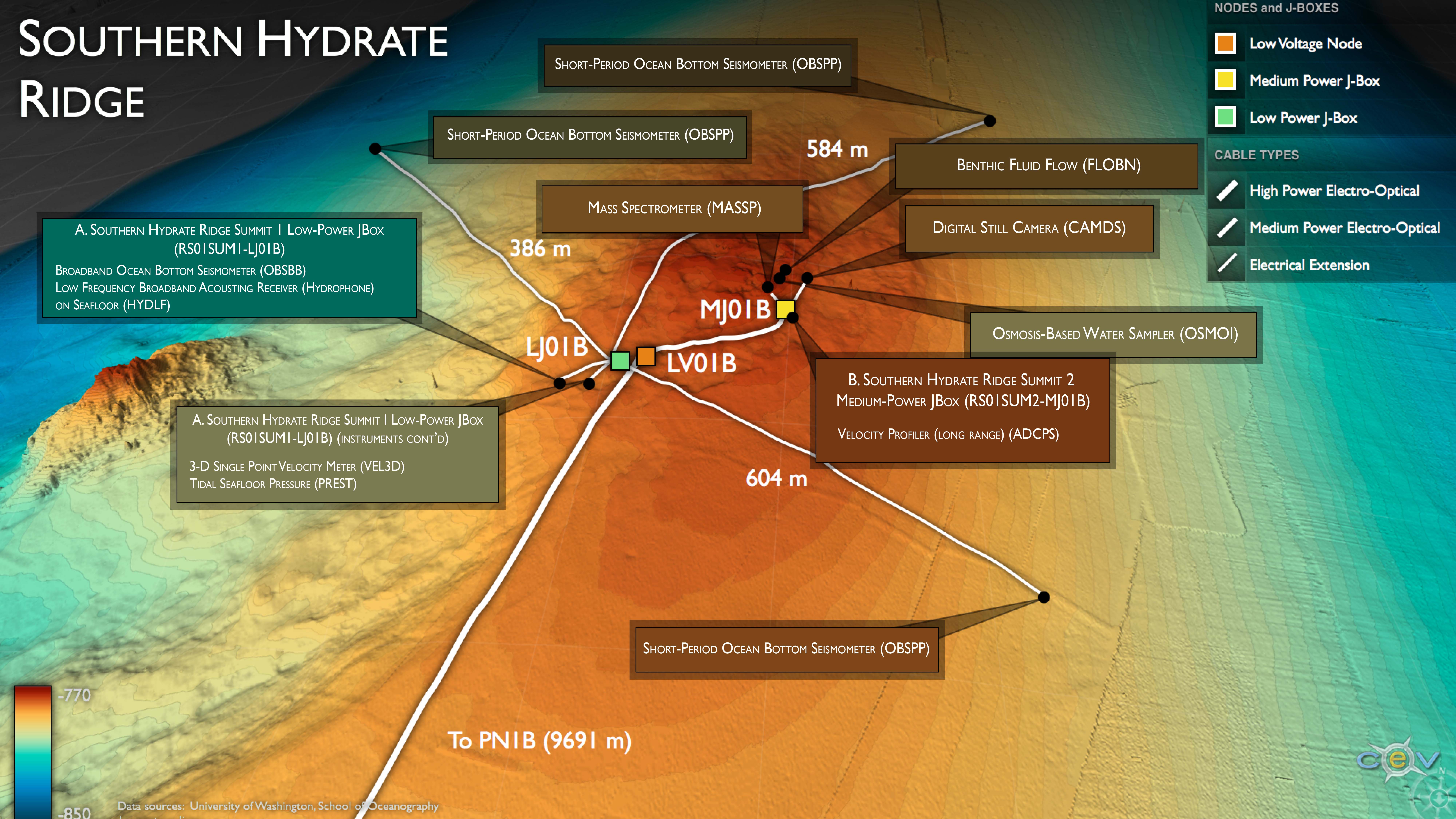
This Medium-Power JBox (MJ01B), connected to a fiber optic cable, rests on the seafloor adjacent to a highly active methane seep called Einstein’s Grotto. Instrumentation at this site is designed to monitor chemistry of the seep, image the seep and associated biota in detail, and image the bubble plume as it rises several hundred meters above the seafloor. The fiber-optic cable provides the JBox with significant power and 1 Gb communication bandwidth for two-way communication to instruments for their operation and transmission of data to shore. This JBox is also co-located with a Low-Power JBox that collects a complementary suite of seafloor and near seafloor water column measurements.
Instruments
This site/platform includes the following instruments. To learn more about an instrument type, select the instrument class-series. To access relevant data streams for an instrument, the instrument code will take you to the OOI Data Portal.
| Instrument Code | Depth | Node | Instrument Class-Series |
Make & Model |
|---|---|---|---|---|
| RS01SUM2-MJ01B-00-FLOBNC101 | 811m | Medium-Power JBox (MJ01B) | Benthic Fluid Flow (FLOBNC) | Tryon, UCSD - CAT meter |
| RS01SUM2-MJ01B-00-FLOBNM101 | 811m | Medium-Power JBox (MJ01B) | Benthic Fluid Flow (FLOBNM) | Solomon, UW - Mosquito benthic flow sampler |
| RS01SUM2-MJ01B-05-CAMDSB103 | 811m | Medium-Power JBox (MJ01B) | Digital Still Camera (CAMDSB) | Kongsberg - Custom Digital Still Camera Assembly |
| RS01SUM2-MJ01B-06-MASSPA101 | 811m | Medium-Power JBox (MJ01B) | Mass Spectrometer (MASSPA) | Girguis, Harvard - cabled Mass Spec |
| RS01SUM2-MJ01B-00-OSMOIA101 | 811m | Medium-Power JBox (MJ01B) | Osmosis-Based Water Sampler (OSMOIA) | TLR, Inc. - OsmoSampler |
| RS01SUM2-MJ01B-12-ADCPSK101 | 811m | Medium-Power JBox (MJ01B) | Velocity Profiler (75 kHz) (ADCPSK) | Teledyne RDI - WorkHorse LongRanger Monitor 75khz |
Equipment Diagram
Water Depth
772 meters
Location
44.5699°N, 125.1468°W