
Posts by ooistaff
OOI Launches QARTOD
WHAT IS QARTOD?
As part of the ongoing OOI effort to improve data quality, OOI is implementing the Quality Assurance of Real-Time Oceanographic Data (QARTOD) on an instrument-by-instrument basis. Led by the United States Integrated Ocean Observing System (U.S. IOOS), the QARTOD effort draws on the broad oceanographic observing community to provide manuals for different instrument classes (e.g. salinity, pH, or waves), which outline best practices and identify tests for evaluating data quality. A common code-base is available on GitHub and actively maintained by IOOS partner Axiom Data Science.
OOI has committed to implementing available QARTOD tests where appropriate. QARTOD is well-documented and actively maintained with an engaged user-base across multiple data collection and repository programs. It has a publicly available code-base with standardized tests and flag definitions that result in simplified, easy-to-interpret results. However, some instruments deployed by OOI, such as seismic sensors, hydrophones, and multispectral sensors, are not well-suited towards QARTOD. For instruments for which there is no existing QARTOD manual, such as seawater pCO2, OOI is implementing “QARTOD-like” quality control (QC).
HOW ARE QARTOD RESULTS COMMUNICATED?
QARTOD utilizes a standardized data-flagging scheme, where each data point for an evaluated variable (e.g. salinity) receives one of the following flags: 1 if the data point passed the test and is considered good; 2 if a test was not evaluated; 3 if the data point is either suspect or interesting/unusual; 4 if the data point fails the test; 9 if the data point is missing. Importantly, QARTOD only Flags data, it does not remove data. In fact, OOI is committed to delivering all available data, whether good or bad; the goal is to provide further information on the possible quality of the data. Furthermore, a flag of 3 does not necessarily mean a data point is bad – it could also mean something interesting or unusual occurred that resulted in the given data point being outside of the expected test threshold.
HOW IS QARTOD IMPLEMENTED BY OOI?
OOI is prioritizing implementation of QARTOD on instruments and variables which are shared across arrays and with broad or high scientific interest, such as CTDs, seawater pH and pCO2, dissolved oxygen, and chlorophyll/fluorescence. OOI is currently implementing the gross range and climatology tests (see this article for a more detailed description of the specific implementation). Note that the climatology test is a site-specific seasonally varying range test and not a World Ocean Atlas-like climatology. These two tests, in addition to other tests under development, utilize thresholds and ranges which are calculated from existing OOI datasets. The code used to calculate the thresholds is publicly available at the oceanobservatories ooi-data-explorations github repository and resulting threshold tables are available at the oceanobservatories qc-lookup github repository. The tests executed and results are added to the datasets as variables named _qartod_results and _qartod_executed, with the relevant tested data variable name prepended (e.g. practical_salinity would be practical_salinity_qartod_results and practical_salinity_qartod_executed). The _qartod_executed variable is a list of the individual results of each of the tests applied stored as a string. The tests applied and the order in which they were applied are stored in the variable metadata attributes. The _qartod_results provide a summary result of all the tests applied.
WHAT IS THE CURRENT OOI QARTOD STATUS?
The IOOS QARTOD manuals define the tests for each instrument class as “Required,” “Recommended,” and “Suggested”. The OOI priority will be the “Required” tests for each instrument class in use by OOI. “Recommended” and “Suggested” test development will be reviewed, with the support of subject matter experts, in the future. The IOOS QARTOD manuals can be found at Quality Assurance/Quality Control of Real Time Oceanographic Data – The U.S. Integrated Ocean Observing System (IOOS).
Current tests under development are gross range (GRT) and climatology (CT). The gap test (GT) will follow next. The syntax and location tests are considered operational checks and are handled within OOI operations and management systems. QARTOD test data will be available in specific locations where OOI supplies data, starting with M2M, and then propagated to THREDDS and Data Explorer. The current status of QARTOD test development and availability is shown in Table 1.
[media-caption path="/wp-content/uploads/2022/10/QARTOD-Table-1.png" link="#"]Table 1: Current Status of Development & Availability[/media-caption]
[media-caption path="/wp-content/uploads/2022/10/QARTOD-Figure-1.png" link="#"]Figure 1: QARTOD “Required” Test Development Timeline[/media-caption]
Read MoreAn Overview of Ambient Sound Using OOI Hydrophones
Adapted and condensed by OOI from Ragland, et al., 2022, doi.org/10.1121/10.0009836.
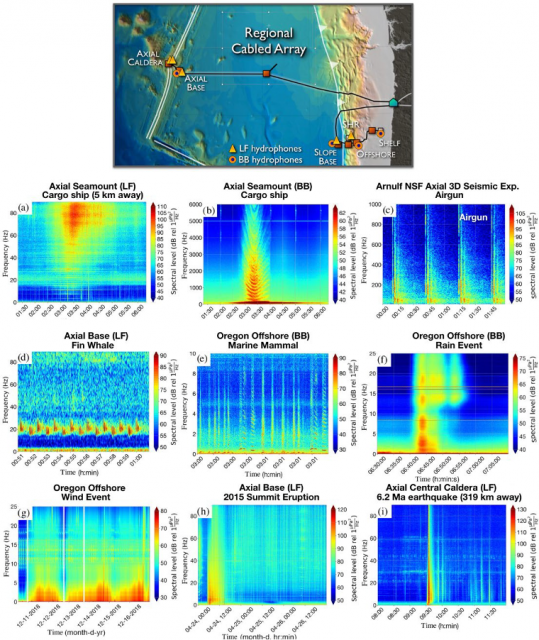
[media-caption path="/wp-content/uploads/2022/11/RCA-highlight.png" link="#"]Figure 1: Highlights of acoustic features from the five low frequency (Fs=200Hz) and six broadband (Fs = 64 kHz) hydrophones on the RCA.[/media-caption]Ragland et al., (2022) provides a wonderful overview of the unique opportunities for data and experimentally driven advancements in acoustics that are provided by (long-term) ambient sound recordings streamed live from hydrophones on the Regional Cabled Array. Figure 1, above (after Figure 5, Ragland et al., 2022), highlights acoustic features from the five low frequency (Fs=200Hz) and six broadband (Fs = 64 kHz) hydrophones on the RCA. Areas of research span the rare ability to conduct offshore monitoring of Fin whale migration, and the seasonal fluctuations and decade-long evolution of their calls, in situ offshore meteorological measurements with high temporal resolution to study wind and rain noise in the NE Pacific, the sound from commercial ships with impacts on the oceanic environment and marine life, ambient noise interferometry, volcanic eruptions, and both local and far-field earthquakes. As the authors note, the RCA-OOI data also provide significant opportunities for the development of machine learning tools for ocean acoustics. This work was supported by an award from the Office of Navy Research. The authors developed a public Python package (OOIPy) to access and explore the hydrophone data more easily (Schwock et al., 2021). OOIPy is also accessible through the OOI website tab Community Tools and Datasets.
__________________________________________________________
Ragland, J., F. Schwock, M. Munson, and S. Abadi (2022) Journal of the Acoustic Society of America, 151, 2085-2100, https://doi.org/10.1121/10.0009836.
Schwock, F., J. Ragland, L. Setiawan, M. Munson, D. Volodin, and S., Abadi (2021). OOIPY v1.1.3: A Python toolbox designed to aid in the scientific analysis of Ocean Observatories Initiative data, https://doi.org/10.5281/zenodo.5889288.
Read More
Southern Ocean Sea Ice Predictability
Adapted and condensed by OOI from Cerovecki, et al., 2022, doi: /10.1088/1748-9326/ac7d66.
Forecasting Antarctic sea ice conditions, including specifics such as the position of the ice edge in the Southern Ocean, are substantial challenges. As a part of the Polar Prediction Project, there is a focus on improving coupled air-sea-ice prediction models and determining key sources of forecast errors. In a recent study, Cerovecki et al. (2022) show that sea ice forecast skill is linked to the accuracy of the surface forcing, and in particular, the net surface radiation. The goal of the study was to quantify errors that degrade the skill of Southern Ocean sea ice forecasts during the freezing season. They conclude that accurately modeling the surface downward longwave radiation (DLW) component of the net surface radiation is critical to sea ice prediction over the Southern Ocean.
The authors review prior results indicating that climate models have different behaviors in different seasons relative to ground truth. In spring and summer, the models over-estimate the net surface radiation whereas in winter the models under-estimate the net longwave radiation. Recognizing that these issues relate to representations of cloud cover, which can be diagnosed using DLW, the authors also note that some models showed DLW biases of up to 100 W/m2 compared to ground truth. These results were based on comparisons at McMurdo Station, Antarctica, whereas the authors were interested in processes occurring near the ice edge where few direct observations are available.
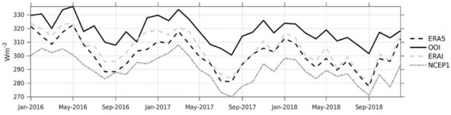
[media-caption path="/wp-content/uploads/2022/11/CGSN-highlight.png" link="#"]Figure 1. Monthly mean downward longwave radiation (DLW) for Jan 2016 – Nov 2018 from the OOI Southern Ocean buoy (solid), and three reanalysis products: ERA5 (black dash), ERA-Interim (long grey dash) and NCEP1 (short gray dash). From Ceroveki et al., 2022.[/media-caption]
The OOI Southern Ocean surface mooring provided a rare source of in-situ air-sea flux data for comparison. The study used DLW from the METBK instrument package on the OOI Southern Ocean buoy to compare with results from the ECMWF Interim reanalysis (ERAI), the ERA fifth- generation reanalysis (ERA5), and the NOAA National Centers for Environmental Prediction reanalysis (NCEP1). Despite some data gaps, the 1 min OOI METBK observations for Jan 2016 – Jan 2020, were critical to determining model biases. Hourly mean DLW data from the two METBK packages were averaged together to create the observational record.
Comparison of the observed monthly mean DLW with reanalysis output showed systematic underestimates by the models relative to the observations. The nature of the offsets is shown in Figure 1 – the reanalysis models do a relatively good job of capturing month to month variability, but with a consistent low bias. The mean offsets range from -13 W/m2 for ERAI to -28 W/m2 for NCEP1. These biases are comparable to those diagnosed at McMurdo Station, and suggest that the ERA5 DLW radiation underestimate is of the order of 20–50 W/m2. This is consistent with the finding that coupled model forecast systems over-estimate sea ice growth.
The authors conclude that a significant deficit in reanalysis DLW, related to the accuracy of cloud representation in the models, is a common problem over the Southern Ocean and impacts the skill of sea ice cover prediction. In particular, the ERA5 reanalysis may underestimate DLW by up to 50 W/m^2 during the during the freezing season. The OOI Southern Ocean data, from the furthest south sustained air-sea flux mooring, proved uniquely valuable in codifying these results.
______________________________
Cerovecki, I, R. Sun, D.H. Bromwich, X. Zou, M.R. Mazloff and S -H.Wang (2022). Impact of downward longwave radiative deficits on Antarctic sea-ice extent predictability during the sea ice growth period. Environ. Res. Lett. 17 084008. DOI: /10.1088/1748-9326/ac7d66.
Read More
Particle Trajectories in an Eastern Boundary Current
Adapted and condensed by OOI from Wong-Ala et al., 2022, doi:/10.1016/j.jmarsys.2022.103757
To study the transport and dispersal of marine organisms during spawning, Wong-Ala* et al. developed and applied a Lagrangian particle tracking (LPT) model to compare and contrast particle drift patterns during the spring transition off the Oregon coast. They studied the Oregon coast as it has distinct upwelling and downwelling regimes and variable shelf width. They contrasted years (2016–18) using Regional Ocean Modeling System (ROMS) with different horizontal spatial resolutions (2 km, 250 m). They found the finer spatial resolution model significantly increased retention along the Oregon coast. Particles in the 250 m ROMS were advected to depth at specific times and locations for each simulated year, coinciding with the location and timing of a strong and shallow alongshore undercurrent that is not present in the 2 km ROMS. Additionally, ageostrophic dynamics close to shore, in the bottom boundary layer, and around headlands not present in the coarser model emerged in the 250 m resolution model. They concluded that the higher horizontal model resolution and bathymetry generated well-resolved mesoscale and submesoscale features (e.g., surface, subsurface, and nearshore jet) that vary annually. These results have implications for modeling the dispersal, growth, and development of coastal organisms with dispersing early life stages.
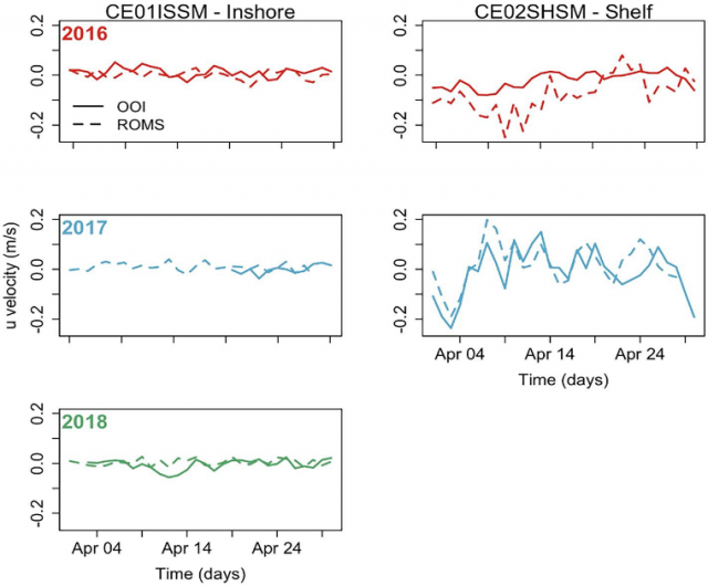
[media-caption path="/wp-content/uploads/2022/11/Endurance-Highlight.png" link="#"]Figure 1: (Fig 9 from Wong-Ala et al. (2022). Comparison of u-velocity (zonal velocity) data between the 250 m ROMS and an inshore mooring and shelf mooring off the Oregon coast collecting data at seven meters depth. The panel is organized by year: 2016 (row 1), 2017 (row 2), 2018 (row 3), and location of data collection: inshore (column 1) and shelf (column 2). In April 2018, there are no data available from the shelf mooring ADCP.[/media-caption]The model applied by Wong-Ala assimilates satellite sea surface temperature and along-track altimetry. Model atmospheric forcing is from the NOAA North American Mesoscale Model (NAM). To validate their model, Wong-Ala et al., used OOI Endurance Array time series data from 2016 to 2018 from the Oregon inshore and shelf moorings (CE01ISSM and CE02SHSM). They compared available OOI zonal and meridional velocities, temperature, and salinity to model output of these parameters for the month of April in each year when they ran their model (Figure 1). They found the modeled currents and temperature from the 250 m ROMS model closely follow the observed data from inshore and shelf moorings compared to the 2 km ROMS. The 250 m ROMS modeled currents and observed currents at the inshore mooring are similar for all three years (Figure 1).
They also found that the 250 m ROMS modeled temperature and observed data are similar in 2017 at the inshore and shelf location. In April 2017 and 2018, the modeled temperature from the 250 m ROMS is about 1 °C cooler than the observed temperatures.
_____________________
*Wong-Ala is a PhD student at Oregon State University. She is a Pacific Islander.
Reference:A. T. K. Wong-Ala, Ciannelli, L., Durski, S. M., and Spitz, Y., Particle trajectories in an eastern boundary current using a regional ocean model at two horizontal resolutions, Journal of Marine Systems, vol. 233, p. 103757, 2022. https://doi.org/10.1016/j.jmarsys.2022.103757.
Read MoreRecovery of Pioneer Array in November
On November 9, 2022, a team of 18 scientists and engineers will leave the dock at Woods Hole, MA aboard the R/V Neil Armstrong on an historic expedition. It will be the nineteenth, and last, expedition to the Coastal Pioneer Array on the New England Shelf (NES). This is because the team will be recovering, but not redeploying the NES Pioneer array as in prior years. Designed to be relocatable, the array will be moved to a new location in theSouthern Mid-Atlantic Bight in early 2024. The ocean observing data collected since 2016 at the NES site, about 75 nautical miles south of Martha’s Vineyard, has provided valuable insights into changing ocean conditions at the Atlantic continental shelf and upper slope. The New England Shelf Pioneer data will remain available to the community for continued analysis.
“The Coastal Pioneer Array has been a true workhorse, providing valuable, consistent data from this important intersection in the ocean, where ocean currents meet in weather-like “fronts,” and where heat, salt, nutrients, and other properties are exchanged between the coast and the deep ocean “said Chief Scientist John Lund, who has been on 18 of Pioneer’s 19 expeditions.
“The impacts of the Coastal Pioneer Array have been many,” added Al Plueddemann, Principal Investigator of OOI Coastal and Global Scale Nodes. “To my knowledge, OOI Pioneer is the first sustained, interdisciplinary shelfbreak observatory. Pioneer data have allowed researchers to identify new shelf-slope dynamics and exchange mechanisms and have given us a first glimpse of what appears to be a changing coastal regime. It is very gratifying to see these outcomes, and to recognize the promise of continued findings using the data for years to come.”
[media-caption path="/wp-content/uploads/2022/11/last_NES_CPM_PMUI-17.jpg" link="#"]This Coastal Profiler Mooring, PMUI-17, was the last Pioneer mooring deployed on the New England Shelf. After providing data through the summer and early fall, it will be recovered in November 2022 and relocated to the Southern Mid-Atlantic Bight in 2024. Credit: Al Plueddemann ©WHOI.[/media-caption]
The Pioneer 19 expedition will be conducted in two legs. The Armstrong will leave port with a nearly empty back deck to allow for carrying back the various parts of the array. During the expedition, three coastal surface moorings, five coastal profiler moorings four coastal gliders, and two global test gliders will be recovered. Additionally, Autonomous Underwater Vehicle (AUV) operations will be conducted in the vicinity of the moored array, as well as CTD (conductivity, temperature, and depth) casts and water sampling at the mooring, AUV, and glider recovery sites. To take full advantage of the time at sea, comparisons of ship and buoy meteorological measurements at the surface mooring sites will be made.
To carry on the collaborative nature of the Pioneer expeditions, during leg 1, the Pioneer Team will be joined by a marine mammal observer from the National Oceanic and Atmospheric Administration and a graduate student from Woods Hole Oceanographic Institution who will be measuring frontal systems, using the shipboard acoustic doppler current profiler and thermosalinograph. Leg 1 will also include a special deployment of a mini-boat surface drifter for an Educational Passages program. This mini-boat was built by students at Waterford School in Connecticut will coincide with the deployment of a similar boat built by students in Ireland.
Leg 2 will include investigators from the New England Shelf Long Term Ecological Research (NES-LTER) Program, who will be conducting underway sampling, and CTD and zooplankton net casts at LTER sites.
An intern from the Marine Advanced Technology Education (MATE) Center will be onboard during both legs.
“While we are all a bit nostalgic about this being the last journey to the Pioneer Array in this location, we are excited about the new science questions that will be answered by the array in its new location.” said Chief Scientist Lund. “We are proud to have been part of collecting nearly a decade’s worth of measurements, which are being used to better understand coastal processes in general with an emphasis on this important New England ocean region.”
Read More
Call for Lightning Talks at OOIFB Town Hall
The Ocean Observatories Initiative Facilities Board (OOIFB) will host a Town Hall at the 2022 Fall AGU Meeting on December 12th from 6:30 pm to 7:30 pm Central Time. The Town Hall will be offered in-person, as well as virtually. The community will have the opportunity to hear the latest information about the OOI Facility Board activities, OOI facility, Pioneer Array relocation plans, and learn about research using OOI data.
The Town Hall will also include a series of lightning presentations where scientists are invited to present one slide in one minute explaining how they have used (or plan to use) freely available observatory data in their respective research. This is your opportunity to highlight your experience with OOI. We hope you will consider presenting a slide in the lightning session.
Time during the Town Hall is limited and we expect to be able to schedule about six lightning talks during the Town Hall. However, all submitted lightning talks will have the opportunity to be presented during the Fall AGU Meeting. The OOIFB has teamed with the OOI booth exhibitor to offer a time slot during the meeting to highlight all of the lightning talks.
Sign-up now to present a lightning talk – If you are using (or plan to use) OOI data and wish to present a lightning talk during the Town Hall, please please apply using the: LIGHTNING TALK FORM by November 21st. From the applications submitted, we will work to select six lightning talks for the Town Hall that can highlight the exciting research that is being done across the entire OOI Facility.
Funding Available for AGU Fall Meeting Registration Fee – Please note, all participants and presenters during the OOIFB Town Hall must be registered for the 2022 AGU Fall Meeting. Funding is available to offset the registration fees for students and early career scientists (ECS) who are presenting a lightning talk. Funding is limited and the first 8 student/ECS applications will be considered for reimbursement. The Lightning Talk application form includes space for requesting registration fee reimbursement.
The workshop is aimed at researchers who are using or are considering using OOI data and/or adding instrumentation to OOI infrastructure and educators at all levels interested in using data from the OOI’s Arrays. We hope to see you at the OOIFB Town Hall!
Event: OOI Facility Board Town Hall
When: Monday, December 12, 2022 from 6:30 pm to 7:30 pm Central Time
Lightning Talks: Apply online here: The form will be open until November 21st.
Where: In person at McCormick Place, Room S106a or Virtual Participation.
The Town Hall agenda and additional details are available here.
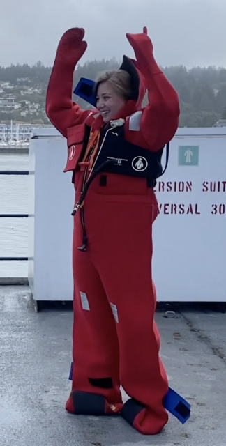
Read MoreStudent Videos Give Inside Look at Research and Safety
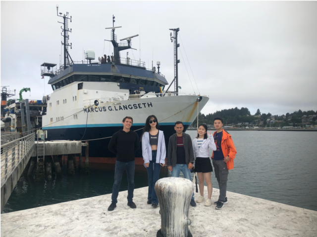
Four students from Queens College were aboard the R/V Marcus G Langseth for a recent ten-day research expedition to the Axial Seamount, a submarine volcano in the northeast Pacific Ocean that erupted in 1998, 2011, and 2015. The students were assisting a National Science Foundation Research team that is deploying autonomous ocean-bottom seismometers on OOI’s Regional Cabled Array as part of a two-year experiment taking place within the predicted time window of the next eruption.
The NSF-funded project is led by William Wilcock from the University of Washington and co-led by Felix Waldhauser, Columbia Climate School’s Lamont-Doherty Earth Observatory, who served as chief scientist on this expedition, Maya Tolstoy (UW), and Yen Joe Tan from the Chinese University of Hong Kong, who also was onboard.
Queens college graduate student Jacqueline Singer was onboard to further work towards her master’s degree. She teamed up with undergraduates Rania Taib, Hema Muni, and Julia Sandke to create two videos – one explains their research, while the other provides an insider’s look at safety issues at sea. In the first video, the students give an in-depth look at how they deployed 15 autonomous ocean-bottom seismometers and how they work. In the second video, the students explain the importance of survival suit training, followed by a humorous look at the complex movements needed to successfully suit up in a “Gumby suit.”
Columbia University PhD candidate Theresa Sawi also provides a written account of the expedition here.
https://vimeo.com/user110037220/studentsataxialseamount
https://vimeo.com/user110037220/gumbysuitdemo
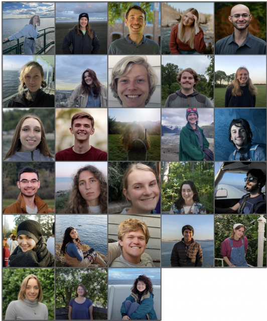
Read MoreVisions’22: Changing Students Lives
From Deb Kelley, UW, in OOI Quarterly Report, 2022.
This year, 25 undergraduate students and three graduate students participated on the Regional Cabled Array Operations and Maintenance cruise as part of the VISIONS’22 at-sea experiential learning program. They include students from the US, India, Saudi Arabia, France, and Kazakhstan. They represent a breadth of disciplines spanning Oceanography (11), Engineering (9: Mechanical, Industrial, Bioengineering, Environmental, and Aeronautics and Astronautics), Biology (6: Biology, Marine Biology, and Microbiology), Geology (1), and Policy Studies focused on the United Nations Convention (1). They stood 4 hour-on, 8 hour-off watches in the remotely controlled vehicle, ROPOS control center, learned how to conduct CTD casts and collect and process fluid samples, and worked on deck. Three additional undergraduate student ambassadors, who have participated in past VISIONS’ expeditions (1-3 years), helped mentor the students. All completed cruise blogs on the Interactiveoceans VISIONS’22 Expedition site, and science-engineering and/or engagement projects that will last a quarter to several years. Two students chose projects involving advanced genetic analyses of vent animals and protists for their Senior Thesis in Oceanography. Based on discussions with past students and what they relayed in their blogs, for many this is a life changing experience. Note: two past VISIONS students are now APL engineers as part of the RCA team.
Read More
Catching the Next Eruption of Axial Seamount
Theresa Sawi, a PhD student in Columbia’s Department of Earth and Environmental Sciences and the Lamont-Doherty Earth Observatory, shares her reflections and more about the science behind a six-day research expedition to Axial Seamount. She gives a behind the scenes look as researchers from Columbia University on the R/V Marcus G Langseth deployed 15 autonomous ocean-bottom seismometers atop Axial Seamount, a submarine volcano in the northeast Pacific Ocean that erupted in 1998, 2011, and 2015. The research expedition was part of a two-year experiment taking place within the predicted time window of the next eruption.
The seismometers were added to OOI’s Regional Cabled Array. To read Sawi’s account, click here.
[media-caption path="/wp-content/uploads/2022/09/Langseth.png" link="#"]15 scientists were onboard the Langseth, with ranks ranging from professor to undergraduate researcher. Credit: Theresa Sawi.[/media-caption]Read More
From Northern California to Ocean Engineer
It seems improbable that someone living in Gridley, a small farm town of 8,000 people in very northern California, would end up as an OOI engineer whose favorite part of the job is being at sea. But that’s the story of Irene Duran, Engineering Assistant III at the Woods Hole Oceanographic Institution (WHOI). Irene just spent the month of July in the Irminger Sea, preparing and monitoring instrumentation before deployment, downloading data after recovery, and checking the health of recovered instruments that had spent a year in the cold and windy north Atlantic. Interestingly, going to sea was not part of her original job description.
Irene’s journey to the ocean was a circuitous one. She attended California State University, Chico and Butte Community College and “meandered into” an engineering major. Most of the college recruiters visiting her university were focused on manufacturing and other building-related trades. In such a land-locked setting three hours from the coast, ocean science-related work was never presented as a possibility.
By happenstance, Irene was presenting her research on “Using Differential Privacy on Histograms for Information Protection” at a SACNAS (Society for the Advancement of Chicano/Hispanics and Native Americans in Science) Conference. There she met George Liles, the co-director of the Woods Hole Partnership Education Program (PEP). He was the first to talk with her about Woods Hole, how engineering fits into science, and the potential for her to have a science-related career. It was also the first time she had heard of Cape Cod. The rest, as it is said, is history.
The summer of her junior year, she ended up in a WHOI biology lab working with Drs. Heidi Sosik and Stace Beaulieu. There she took on the task of testing cameras for a small-sized, low-cost, low-power plankton imaging system. From that experience, she turned her attention to underwater instrumentation.
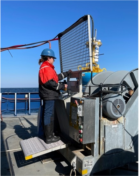
[media-caption path="/wp-content/uploads/2022/09/Irene-at-work.png" link="#"]Irene at work aboard the R/V Neil Armstrong. Credit: Sheri N. White © WHOI.[/media-caption]The following summer in 2019, Irene returned to WHOI, this time as a Summer Student Fellow, working in the REMUS Lab with Chris Rauch and Gwyneth Packard. Her task in this lab was working on developing a lighting system to explore different light configurations that worked best in fully illuminating images taken by the REMUS Autonomous Underwater Vehicles (AUVs).
Both summer experiences caused her to fall in love with the area and the work. Directly after she graduated in 2020 with a degree in Mechatronic Engineering (geared to robotics and automation), she left her family, friends, and her familiar life, and headed east to return to Cape Cod. She moved without a job, but was determined to work at WHOI. Irene spent a seven-month stint at the local grocery store before an appropriate engineering job opened up at WHOI with the Ocean Observatories Initiative (OOI) and the Upper Ocean Processes Group Meteorological Calibration Lab. “It was exactly what I wanted to do – an engineering position working with surface and subsurface instrumentation,” she explained. Her primary responsibility on land is refurbishing and calibrating meteorological sensors that adorn the top of OOI Surface Moorings and other mooring sites world-wide
Irene explained that OOI was and remains a great match. “The people in OOI and Calibration Lab were so welcoming and right off the bat, I felt very comfortable with everyone I worked with.” She also mentioned that she liked how many women work in OOI. Irene’s immediate supervisor, Dr. Sheri N. White, made it possible for Irene to go to sea, even though it wasn’t in her initial job description.
Going out to sea is Irene’s favorite part of her job in spite of the long hours, strenuous work, done often in difficult conditions. “In some ways being at sea feels like a vacation, even though it is clearly not. We are working all of the time, but we get to focus on just one thing. We don’t have much access to life back on land and staying focused on one thing is very refreshing. I feel refreshed coming back from sea, that’s for sure,” Irene said. She’s been to sea for four OOI deployment and recovery expeditions.
In addition to her numerous responsibilities on OOI sea-going cruises, Irene likes to write blogs in her spare time. She enjoys sharing the perspective of what it is like to work at sea, what life is like aboard a ship, and what it is like to make a living as an oceanographer. She writes her blogs in Spanish so the word gets out to a broader audience. “So few of us get to do this work. It is really unique and I like to share what it is like with others,” she added.
Irene credits her supervisor, Dr. Sheri N. White, for giving her opportunities to advance her career and expand her skills. As an example, on the next cruise to the OOI Coastal Pioneer Array this fall, Irene will assume the roles of both Instrument Lead and Profiler Mooring Lead. For this, Irene will be working with buoys, Acoustic Doppler Current Profilers and Wire-Following Profilers – helping to recover them, download data, and prepare them for refurbishment. This experience will be a good stepping stone for her to assume additional responsibilities and opportunities to be on the water in the future. Irene’s goal is to one day be the Chief Scientist on an OOI cruise.
Read More