
Posts by ooistaff
Canadian and OOI Gliders Meet in Pacific
In an important collaborative undertaking, the Ocean Observatories Initiative (OOI) Glider 363 and a Fisheries and Oceans Canada (DFO) Glider crossed paths along Line P, a transect line in the northeast Pacific. This modern day “intersection” provides an opportunity for scientists to have co-located science profiles to match up with sensor data, but also an efficient way to extend data about ocean conditions along Line P throughout the year.
Line P consists of 27 stations extending from Vancouver Island to Ocean Weather Station Papa (OWSP), also known as “Station Papa.” OSWP (located at 50°N, 145°W) has one of the oldest oceanic time series records dating from 1949-1981. This 32-year-old record is supplemented by data collected by shipboard measurements along Line P conducted by DFO three times/year. The US National Oceanic and Atmospheric Administration also has a surface mooring at Station Papa, which contributes year-round data to this important record. Beginning in 2014, OOI also enhanced Station Papa with an array of subsurface moorings and glider measurements.
An important intersection
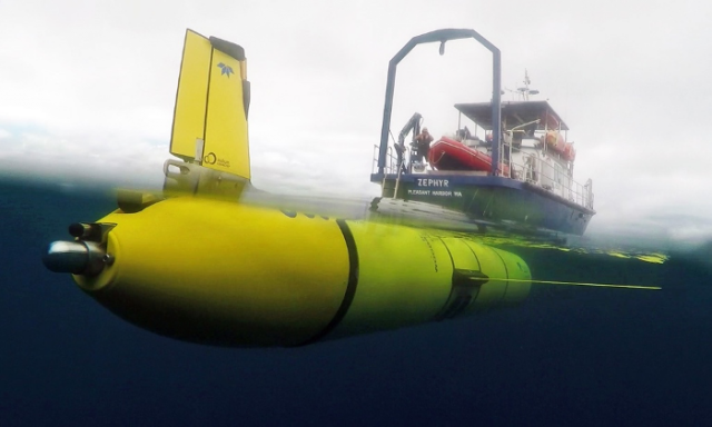
[media-caption path="/wp-content/uploads/2022/09/image012.png" link="#"]The OOI glider left from Newport, OR aboard the RV Zephyr and was deployed on July 3 in open ocean over the Juan de Fuca Ridge. The glider transited along Line P to the Papa Array starting from station P16. A DFO glider was traversing Line P at the same time, providing an opportunity for US and Canadian scientists to have co-located profiles to match up with sensor data. [/media-caption]The DFO glider was deployed in late May returning from OWSP. The OOI glider left from Newport, OR aboard the RV Zephyr and was deployed on July 3 at 46 N 130W in open ocean over the Juan de Fuca Ridge. The glider transited along Line P to OOI’s Global Station Papa Array starting from station P16, which is in international waters just outside the Canadian EEZ. A DFO glider was traversing Line P at the same time, providing an opportunity for US and Canadian scientists to have co-located profiles to match up with sensor data.
At the point of the cross-over the OOI glider had been at sea for about 40 days. Both OOI’s and DFO’s glider have very similar sensors onboard that measure temperature, salinity, pressure, oxygen, optical backscatter, chlorophyll, and colored dissolved organic matter. These measurements when compared to historical data provide insight into existing and possibly changing conditions in the water column.
“At a very basic level these deep-ocean rendezvous provide us with an opportunity to compare the sensor data mid-deployment, instead of just at the start or end of their respective deployments. This can help us look for any trends or offsets that might indicate sensor issues – such as aging, fouling, and other issues that may impede performance. This information helps people understand and be able to use data from these gliders,” explained Peter J. Brickley, OOI’s Glider Lead. “The other outcome is that our joint glider data can contribute extra sampling along Line P. While there are several cruises along this line every year, those efforts are spaced far apart in time (sometimes several months). Autonomous gliders can fill some of the gaps, are relatively inexpensive to operate, and can help better delineate conditions, including changing anomalies as they occur.”
Another contributing factor to making this initial glider cross-over a useful test case is that a scheduled DFO Line P cruise on the Canadian Coast Guard Ship John P. Tully was happening concurrently along Line P. The team aboard the Tully started sampling in early August and are scheduled to complete sampling by the month’s end. The ship collected some data in the vicinity of both gliders, offering another opportunity to compare and contrast data.
[media-caption path="/wp-content/uploads/2022/09/zephyr2.png" link="#"]The OOI glider deployed from the R/V Zephyr heading north to reach Line P in time to cross-over with DFO’s glider to share and contrast data collected. Credit: R/V Zephyr ©WHOI. [/media-caption]While the glider cross-over is an important first, it is emblematic of the ongoing cooperative effort between the Canadian DFO, NOAA, and OOI teams sampling in this important region. Communications occur regularly between OOI team members and the Chief Scientist conducting DFO shipboard sampling, as well as between OOI and NOAA personnel.
Added Brickley, “This recent excursion along Line P was planned, but also a serendipitous opportunity that could be leveraged quickly. Once we all have the chance to assess the data provided, we’ll be in a better position to explore making this a more regular occurrence. If it turns out that our sampling schemes are easily aligned, that could be another step to help advance understanding of ocean processes from coastal, eutrophic waters into the heart of the high nitrate, low chlorophyll area of the NE Pacific.”
Read More
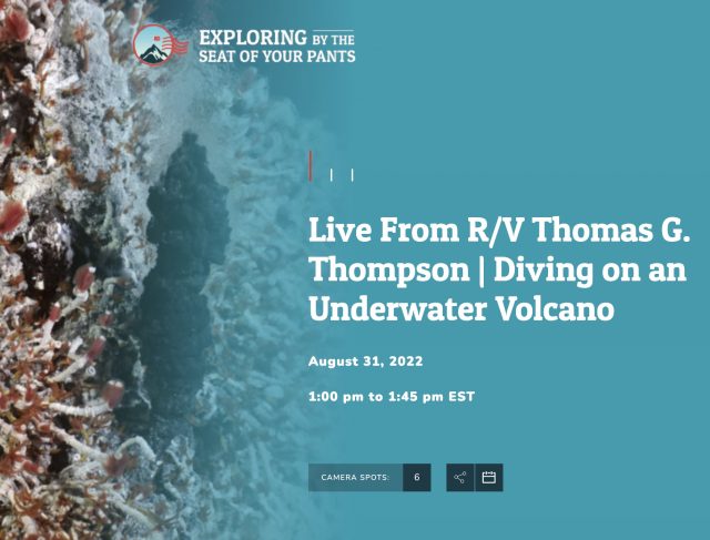
Sept 21 Noon Eastern: Live Ship-to-Shore Video from Endurance 17
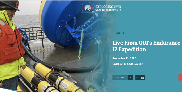
Mark your calendar to tune in to a rare opportunity to see live OOI action from the R/V Thomas G. Thompson: Wednesday September 21 at noon eastern. Exploring by the Seat of Your Pants will be interviewing Chief Scientist Jonathan Fram as he and his team get ready to depart on the 17th recovery and deployment expedition of the Coastal Endurance Array. It should be a fun and informative operation. Register here, then tune in.

Ride Along with Endurance 17 Expedition
Don’t miss this opportunity to go to sea and participate in an OOI recovery and deployment expedition without having to board a ship. Follow along as progress is reported daily here.
A sneak peek follows:
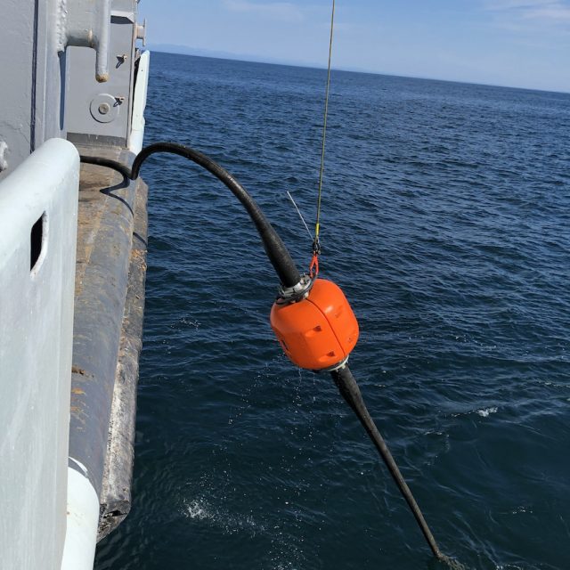
[caption id="attachment_24411" align="alignnone" width="640"]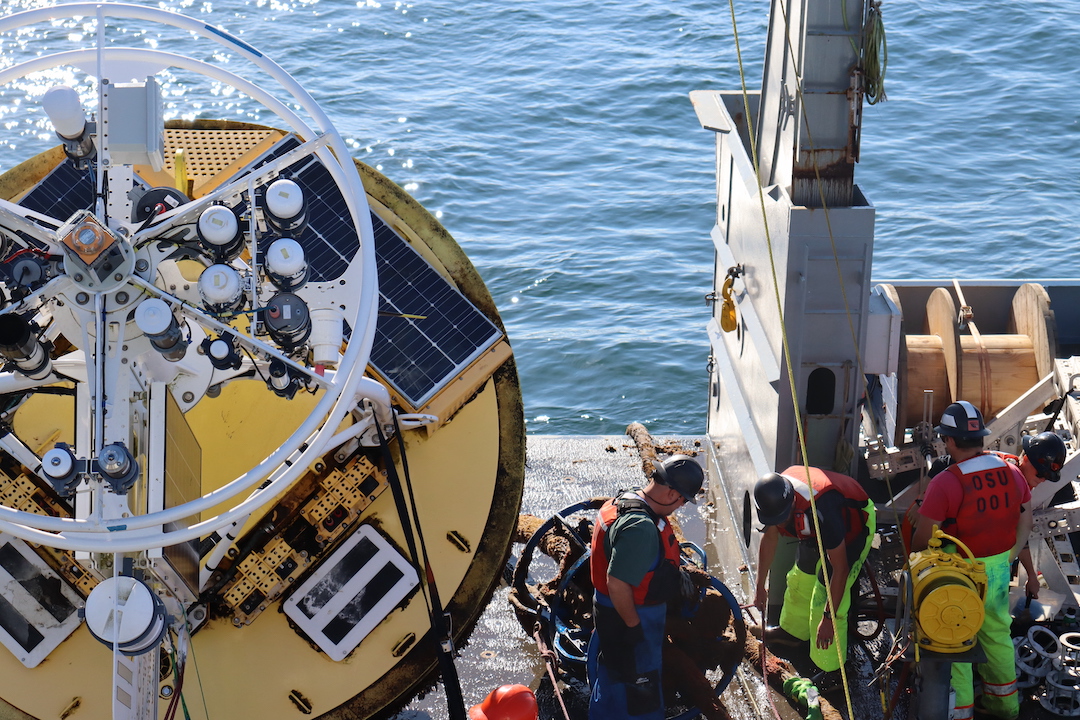 The Washington Inshore Surface Mooring is secured after having been brought onboard.[/caption]
[caption id="attachment_24410" align="alignnone" width="469"]
The Washington Inshore Surface Mooring is secured after having been brought onboard.[/caption]
[caption id="attachment_24410" align="alignnone" width="469"]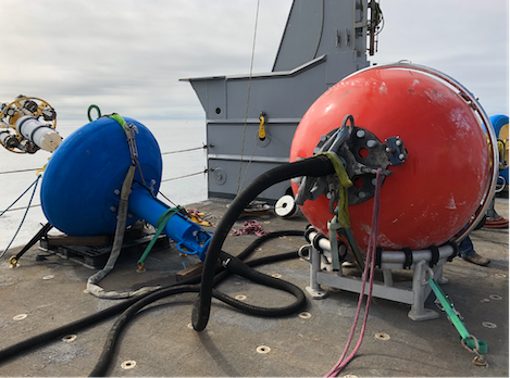 Washington Offshore Surface Piercing Profiler Mooring awaiting deployment.[/caption]
[caption id="attachment_24409" align="alignnone" width="640"]
Washington Offshore Surface Piercing Profiler Mooring awaiting deployment.[/caption]
[caption id="attachment_24409" align="alignnone" width="640"]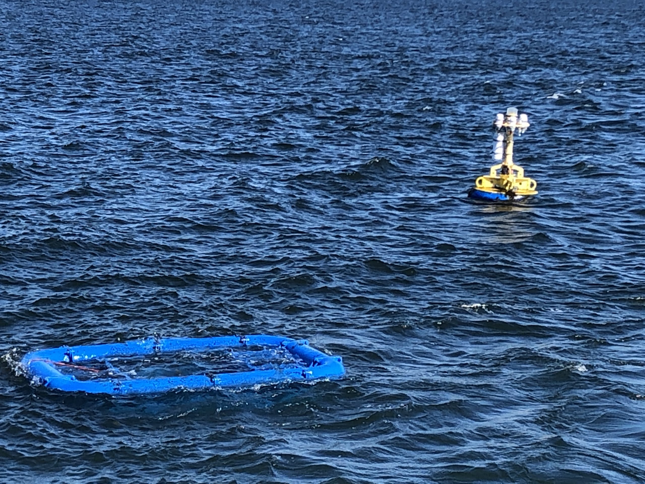 The large blue rectangle is the bottom of a multi-function node, which contains instruments and power, and sits on the ocean bottom. Here it is awaiting recovery.[/caption]
Read More
Scientists and Fishers Learning from One Another

At a recent meeting of the Cape Cod Commercial Fishermen’s Alliance, it was evident how much can be learned when scientists and fishers share information. An example was the shifting location of the Gulf Stream. Fred Mattera, President of Commercial Fisheries Research Foundation of Rhode Island, wondered why the temperature of the continental shelf was 72 degrees in December. He contacted Glen Gawarkiewicz, a Woods Hole Oceanographic Institution senior scientist, to share his observation. Gawarkiewicz used data from OOI’s Coastal Pioneer Array to confirm that the Gulf Stream, which carries warm and salty water, had shifted 120 miles north. Gawarkiewicz explained to the audience that he would have never identified this change if it hadn’t been for Mattera’s contact.
This is but one example of how those who use the ocean and those who study it can benefit by sharing information. To read more:
Read More
Cadet Reports on First Voyage on a Research Vessel
Massachusetts Maritime Academy First-Class Cadet, Ella Strano, recently returned from two months aboard the R/V Neil Armstrong. Ella participated as a working crew member for the recovery and deployment of OOI’s Global Irminger Sea Array in July, followed by deployment of moorings and sampling equipment for the Overturning in Subpolar Arctic Project (OSNAP). She had a few days in shore in Reykjavik, Iceland, as the science parties and equipment were swapped out and onboard.
In a word, Ella described her experience as “Awesome!” and one that was a very different experience than that of her peers’ summer internships shipboard experiences. The majority of cadets at the Massachusetts Maritime Academy shipped out on cargo vessels and bulk carrier tugs for their first experiences of life at sea.
Being one of a few stationed on research vessels presented both opportunities and challenges.
“I definitely had to go with the flow,” she explained. “But l had the opportunity to learn not only from the crew, but from the scientists on board.” Ella’s minor is marine biology so she enjoyed the science aspects of the expedition, even though her responsibilities were primarily with helping to keep the ship operational so the science could be conducted.
Part of MA Maritime’s mission is to provide their students with hands-on at-sea experience so they understand the language and culture of shipboard life. In meeting the spirit of the experience, Ella did almost everything aboard the ship while she was a mate on the Armstrong. During the Irminger expedition, her duties were mostly on deck. She worked with the mooring team and observed how deployment and recovery operations could be conducted safely and successfully. Ella joked that she also did her fair share of cleaning the ship during her first month at sea.
[media-caption path="/wp-content/uploads/2022/09/Working-Aframe-2-scaled.jpg" link="#"]Ella Strano operating the Aframe used to recover and deploy OOI moorings. [/media-caption]During her second stint for the OSNAP expedition, her duties turned more inward and included work in the engine room, on the bridge, and even helped maneuver the ship to stay on station—a critical task for any science operation at sea. She had her hand in everything on the ship, except for the galley, which was left to the professionals.
Ella also experienced a fair share of weather during her initial trip to the North Atlantic, but was pleased that in spite of some low-pressure and high wind days, the ship never had to abandon its mission to find shelter from the weather.
After two months at sea, Ella said it affirmed what she’s interested in doing after graduating next year. After disembarking from the Armstrong, she said, “I love this. It’s so cool that people get to go out to sea and be involved with science, but not necessarily specialize in one area of science.” She sees life aboard a research vessel as offering her the opportunity to be involved with many different science initiatives, learn what’s going on, and never get bored.
Ella said there seems to be an uptick of interest in working aboard science research vessels as she was one of seven of her classmates who sought such a placement, and only three succeeded. If this holds true that would be good news for research ships, which often have to compete for staff who have the potential to earn more working aboard commercial vessels.
Ella’s experience offered something of greater value to her. “There was a really good camaraderie between the science group and the officers,” she explained. “We were all working together and share experiences during mealtimes and cheese-30 every day”. (A spread of cheese and meats is provided every day at three o’clock aboard the Armstrong as a break and snack). “The crew really tried to make life pleasant aboard the ship, which was great because we were at sea for a long time.”
[media-caption path="/wp-content/uploads/2022/09/ella-on-bridge.png" link="#"]Ella Strano on the bridge of the R/V Neil Armstrong. [/media-caption]If all goes as planned, Ella will graduate next year with a Bachelor of Science Degree in Marine Transportation from MA Maritime and with an enlisted unlimited tonnage, third officer certificate from the U.S. Coast Guard. She hopes to find a place aboard the Armstrong or other science-related position, inspired by a full female bridge team, and science party comprised of 50 percent women, and led by a female chief scientist, all of whom showed her what is possible.
Read More
Interview from Axial Seamount
In case you missed it, you can watch the video of Chief Scientist Michael Vardaro and student Andrew Paley being interviewed live aboard the R/V Thomas G. Thompson during the Regional Cabled Array for its eighth annual operations and maintenance cruise. The Exploring by the Seat of Your Pants program is designed to give students an opportunity to see scientists in action in the field, in the hope of piquing their interest in science and perhaps pursuit of scientific careers. (The piece is 45-minutes long so takes a moment to load. If you prefer, click on this link: https://www.youtube.com/watch?v=K–RlkjMjLo).
[embed]https://youtu.be/K–RlkjMjLo[/embed] Read MoreDr. George Voulgaris Appointed New OOI Program Director
The National Science Foundation (NSF) announced the appointment of Dr. George Voulgaris as the new Program Director for the NSF-funded Ocean Observatories Initiative. Voulgaris joins NSF from the School of Earth, Ocean, and Environment at the University of South Carolina, where he was a full professor and held a variety of administrative appointments throughout his career. Voulgaris assumes the OOI leadership role that was jointly provided by NSF Section Heads, Lisa M. Clough, Ocean Section, and Bauke (Bob) H. Houtman, Integrative Programs since 2016. Bob retired at the end of 2022, but Lisa continues to support George in his new role and remains engaged with the OOI Facility.
This position marks a return to NSF for Voulgaris who served as a Program Director for NSF’s Physical Oceanography Program from July 2017 to August 2020.
Lisa Clough said, “Bob and I are excited to be turning over the reins of the OOI at NSF to George, who is very well-suited to the task. George has more than 30 years-experience in ocean observations systems, as well as 3+ years of experience as an NSF program director. With this experience, he brings to OOI the unique perspective of understanding what quality ocean observations require from standpoint of a system operator, scientist and educator, and as a federal funder. Unquestionably, George will help the OOI deliver on its mission to be one of the world’s premier ocean observing systems.”
Voulgaris plans to facilitate the work of OOI operators and the OOI Facility Board (OOIFB) as both respond to the challenges and opportunities informed by the broader oceanographic community. “Coming from an institution with no major oceanographic facilities, I have a great appreciation of the opportunities OOI provides to faculty, researchers, and students with no access to such facilities,” Voulgaris explained. “I hope to help OOI continue to provide these services and further enhance its impact through new scientific discoveries and synergies with other partners vested in ocean discovery and through new emerging technologies. I am excited be a part of OOI as its impact grows both nationally and internationally.”
Voulgaris joined the University of South Carolina as Assistant Professor in 1998 and was promoted to the ranks of Associate and Full Professor in 2005 and 2008, respectively. His research is in the area of Coastal Processes incorporating aspects of both Marine Geology and Physical Oceanography. His many externally funded research projects (e.g., NSF, National Oceanic and Atmospheric Administration, the Department of the Interior) range from exploring the surf-zone to continental shelf circulation and often include assessing sediment transport and wave-current interactions, using hydrodynamic and turbulence measurements in the field and laboratory. For the last decade, he has been active in operational oceanography utilizing coupled wave and current numerical models and HF and VHF Radar measurements for measuring surface currents and ocean waves.
Voulgaris has authored or co-authored over 100 peer-reviewed manuscripts, 130 published abstracts and 45 technical reports, source-codes, and other non-refereed publications. In recognition of his research contributions, he was awarded the University of South Carolina Research Foundation award for Science and Mathematics in 2014. Voulgaris has served as a member of the Scientific Committee of the Key Laboratory for Coast and Island Development, Ministry of Education, Nanjing University, China, and on the Board of Directors for the Southeast Coastal Ocean Observing Regional Association. Voulgaris is also a member of the American Geophysical Union, the American Association for the Advancement of Science, and the Marine Technology Society.
Voulgaris received a bachelor’s degree in Geology from the University of Patras in Greece and a Ph.D. in Oceanography from the University of Southampton in the United Kingdom.
The Ocean Observatories Initiative is a 25-year ocean infrastructure project funded by the National Science Foundation to gather and deliver physical, chemical, and biological measurements from the ocean, atmosphere, and seafloor to anyone with an internet connection. The program includes moored instrument arrays and autonomous underwater vehicles deployed at critical locations in the coastal and open ocean worldwide. Data from the observatories help researchers address questions across short and long time periods, small and large spatial scales, and from the ocean surface to the seafloor. OOI is managed by the Woods Hole Oceanographic Institution (WHOI) and implemented by WHOI, the University of Washington, and Oregon State University.
Read More
Data Stream Parameters Simplified to Ease Access

We are in the process of changing the values of data stream parameters to be more Climate and Forecast (CF) compliant and to make the data you are looking for easier to find. For example, the parameter “pressure_depth” has been renamed to simply “pressure.”
The value change process started with pressure_depth and will be ongoing in our attempt to improve access to OOI data for all users. This next round of changes is larger in scope, and changes are documented in file format (excel, .csv) and accessible on the Changes Affecting Data page. Note that the changed values will take effect immediately in the M2M interface while pre-processed staged files will take up to a week to refresh. These updates were released on August 25th at 1:00pm ET.
Should you have any questions about this process or others, please don’t hesitate to reach out to our HelpDesk.
Read MoreCall for Applications: OOIFB Board Position
The Ocean Observatories Initiative Facility Board (OOIFB) provides independent input and guidance regarding the management and operation of the National Science Foundation-funded Ocean Observatories Initiative (OOI). The OOIFB works to expand scientific and public awareness of the OOI, and ensure that the oceanographic community is kept informed of developments of the OOI.
The OOIFB is soliciting applications to fill one open membership position. The appointment will fill the remainder of an unexpired term and will be effective starting in October 2022 and run through May 2023. The selected individual will be eligible to serve two additional 3-year terms. The OOIFB holds at least one in-person meeting per year and one web conference each month.
Scientists with experience using scientific observing systems, such as the OOI, are encouraged to apply. In an effort to maintain the expertise and disciplinary depth on the committee, we are particularly interested in applicants with research experience using data from the OOI Global Arrays, Endurance Array, and/or from institutions along the U.S. West Coast. However, all interested applicants will be considered.
The responsibilities of the OOIFB may include, but are not limited to, the following:
- Serving as the prime scientific and technical conduit between the oceanographic community and NSF regarding the OOI.
- Examining the accomplishments and work flow of the OOI Operator, in order to provide feedback regarding the OOI Annual Work Plans (AWPs).
- Via workshops, community meetings, and/or other mechanisms, stimulate and engage the user community in order to keep the accomplishments of the OOI at the cutting edge of scientific inquiry and technological innovation.
- Developing and implementing strategies to expand scientific and public awareness of the unique scientific and technological opportunities of the OOI.
Applications should be submitted to Annette DeSilva, at the OOIFB Administrative Support Office (desilva@ooifb.org), and must include a letter of interest and an academic CV. Applications are due by September 25, 2022. Applications will be reviewed by the OOIFB, who will give due consideration to the qualifications of applicants, as well as the maintenance of gender, career level, discipline, and regional balance on the OOIFB. For more information about OOIFB and its activities, please visit the website:https://ooifb.org or contact Kendra Daly, OOIFB Chair (kdaly@usf.edu).
Two Decades of Mooring and Ship-Based Observations from the Newport Hydrographic Line
C.M. Risien, M.R. Fewings, J.L. Fisher, B.T. Cervantes, C.A. Morgan, J.A. Barth, P.M. Kosro, J.O. Peterson, W.T. Peterson, and M.D. Levine
In the Northern California Current System (NCCS), during spring and summer months, equatorward winds drive the upwelling of cold, nutrient-rich, and oxygen-poor waters from depth onto the shelf, fueling a highly productive marine ecosystem that supports valuable commercial fisheries. Oceanographic conditions in the NCCS vary on temporal scales from hours to decades. In contrast, grant-funded research typically consists of shorter-term studies (3-5 years). While such studies resolve intra-annual and perhaps inter-annual variability, they do not capture decadal scale variability that is critical for climate studies.
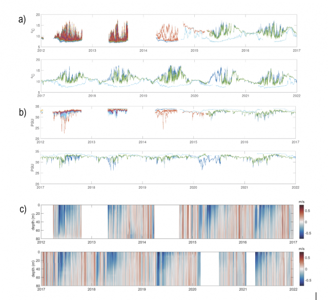
Risien et al. (2022), present two new decadal-scale data products. The first is ~550 gridded, cross-shelf hydrographic sections of temperature, salinity, potential density, spiciness, and dissolved oxygen from data collected biweekly to monthly from March 1997 to present along the Newport Hydrographic Line (NHL; 44.6°N, 124.1–124.65°W) off Newport, Oregon, USA, mostly by NOAA programs. They also present monthly climatologies derived from these observations.
The second data product is 23 years (1999–2021) of mooring temperature, salinity and velocity data — collected by five programs (OSU-NOPP, GLOBEC, OrCOOS, NANOOS/CMOP, OOI) at NH-10 (44.6°N, 124.3°W), 10 nautical miles west of Newport, Oregon along the NHL — that they stitched together into one coherent, quality-controlled data set (see figure above).
Making available such multi-decadal data sets, which they plan to release via public repositories, is essential to enable scientists to characterize natural and anthropogenically-forced variability; resolve cause-and-effect relationships in Earth’s climate and marine ecosystems at intra-seasonal, seasonal, inter-annual and decadal time scales; and verify climate models. These new gridded and concatenated data products show that long-term ocean observing efforts require multi-generational teams with a wide range of skills and a shared vision that is motivated by science and ocean monitoring needs.
Read More