
News
BGC Workshop Cooks Up a Recipe for Collaborative Research
Thirty-six researchers from 19 institutions from five countries converged on the Woods Hole Oceanographic Institution for three days (June 16-18) to participate in a workshop designed to enhance the use of data from biogeochemical (BGC) sensors on Ocean Observatories Initiative arrays. A product of the workshop will be the “OOI Biogeochemical Sensor Best Practices and User Guide” designed to standardize the use of BGC sensor measurements and promote best practices in their research application.
In summer 2021 the NSF-funded OOI Biogeochemical Sensor Data Working Group was established to develop guidelines and best practices for using OOI biogeochemical sensor data to broaden users and applications of these data, and build community capacity to produce analysis-ready data products. The Working Group convened regular virtual meetings beginning with a three-day virtual workshop in July 2021. Members developed a draft best practices guide with explicit recommendations for end users working with data from four sensor sub-groups: dissolved oxygen, inorganic carbon parameters, bio-optics, and nitrate. The five chapters of the best practices guide cover background on the OOI arrays and the biogeochemical sensors deployed on them, data QA/QC and data access, and each of the four sensor sub-groups listed above.
Current and prospective OOI biogeochemical sensor data users gathered together with the Working Group members at the June workshop to review and discuss the best practices guide and to explore scientific questions that can be explored with these data. The discussions were lively and productive. Small breakout groups discussed scientific research ideas using OOI biogeochemical sensor data, with the hope that these discussions would kickstart research collaborations, and help inform a planned follow-on peer-reviewed publication (e.g. a Frontiers in Ocean Observing article) to present the exciting science that OOI biogeochemical data and the best practices guide will enable. The second goal of the workshop was to solicit the revisions and edits needed to finalize the best practices guide in advance of dissemination to the wider community through Ocean Best Practices.
The workshop was a huge success. Said participant Michael Vardaro from the University of Washington and a member of the OOI Regional Cabled Array Data Team, “It was a great workshop. I hope we and NSF can inspire other interested early career scientists to organize more workshops like this. They ask hard questions, which ultimately will make the program better!”
Over the past year Sophie Clayton, Old Dominion University, Hilary Palevsky, Boston College, and Heather Benway, Woods Hole Oceanographic Institution have facilitated the Biogeochemical Working Sensor Data Group meetings and preparation of the best practices guide.
“We’ve spent the past year working with a great group of early career and experienced researchers on developing best practices for maximizing the use of biogeochemical data from OOI sensors, “ said Sophie Clayton.
“The workshop gave us all a great opportunity to meet in person and discuss a wide range of exciting research ideas that the OOI BGC data will enable. We were also so pleased to connect and see how much new progress we made in just three days thanks to being all in the same place together,” added Hilary Palevsky.
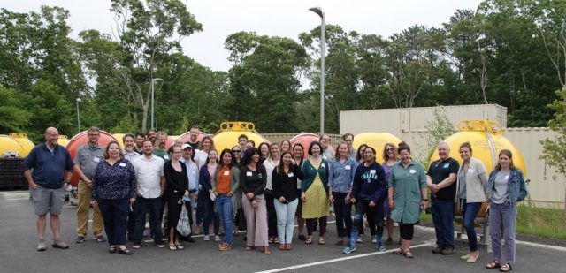
[media-caption path="/wp-content/uploads/2022/06/BGC-Workhshop.jpeg" link="#"]Participants at the end of a three-day Biogeochemical Sensor Workshop held at Woods Hole Oceanographic Institution June 17-19, 2022. Photo: Mai Maheigan ©WHOI.[/media-caption]The working group members are: Annie Bourbonnais, (University of South Carolina), Susan Hartman (National Oceanography Centre), Hilde Oliver (WHOI), Kristen Fogaren (Boston College), Merrie Beth Neely, (Global Science and Technology – embedded contractor at NOAA), Filipa Carvalho (National Oceanography Centre), Andrew Reed (OOI – CGSN), Isabela Le Bras (WHOI), Alison Chase (University of Washington – Applied Physics Laboratory), Cara Manning (University of Connecticut), Rob Fatland (University of Washington), Ellen Briggs (University of Hawaii at Manoa), Christina Schallenberg (University of Tasmania), Ian Walsh (Freelance Researcher), Jennifer Batryn (WHOI), Christopher Wingard (Ocean Observatories Initiative Endurance Array), Jonathan Fram (Oregon State University (OOI)), Roman Battisti (University of Washington/NOAA PMEL), Dariia Aamanchuk (Dalhousie University), Jennie Rheuban (WHOI), Rachel Eveleth (Oberlin College) and Joseph Needoba (Oregon Health & Science University).
The additional participants who reviewed the draft Best Practices and User Guide and attended the workshop are: Kohen Bauer (Ocean Networks Canada – University of Victoria), Baoshan Chen (Stony Brook University), Jose Cuevas (Boston College), Susana Flecha (Spanish National Research Council), Micah Horwith (Washington State Department of Ecology), Melissa Melendez (University of Hawaii at Manoa), Tyler Menz (Stony Brook University), Al Plueddemann (WHOI/OOI), Sara Rivero-Calle (University of Georgia), Nick Roden (Norwegian Institute for Water Research), Pablo Nicolás Trucco-Pignata (University of Southampton – National Oceanography Centre), Michael Vardaro (University of Washington, OOI), and Meg Yoder Boston College.
Read MoreRecap of Successful NE Pacific Workshop
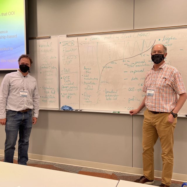
The Ocean Observatories Initiative Facility (OOIFB) hosted a well-attended three-day workshop (June 7-9), followed by an optional Q&A data workshop on June 10. The workshop explored research opportunities using OOI data and its infrastructure to advance understanding of ocean processes in the NE Pacific. More than 100 people attended the workshop, 70 in-person, in the first such event in two years, and 30 virtual participants.
[media-caption path="/wp-content/uploads/2022/06/20220607_105055-2-scaled.jpg" link="#"]The workshop consisted of a mix of plenaries, breakout groups, posters, and many informal, productive discussions about how to maximize use of OOI data. Photo: Abby Ernest-Beck, URI.[/media-caption]
“Not only was it exciting to be with colleagues after all of this time,” said Kendra Daly, chair of the OOIFB, “the number of new ideas discussed on how to expand use of OOI data and extend partnerships with other observatories in the region was truly invigorating. The workshop laid the groundwork for new ways in which to use OOI data to explore research questions relevant to the NE Pacific.”
The three-day event alternated between plenaries on topics such as the “Warm Blob,” preparing for the next eruption at Axial Seamount, and how OOI data are used in modeling efforts and in the classroom. Lively breakout group sessions covered topics ranging from how to access OOI data, to major scientific questions, to research aimed at specific geographic regions, to potential broader impact initiatives.
The workshop was funded by the National Science Foundation.
For those who missed the workshop, all presentations and posters are available online here. Recordings of the workshop will be available online in the coming weeks.
Read MoreMonth-long Expedition to Refresh Irminger Sea Array
In late June, a team of 15 scientists and engineers headed to the Irminger Sea, a region with high wind and large surface waves in the North Atlantic. This remote ocean region is one of the few places on Earth with deep-water formation that feeds the large-scale thermohaline circulation.
[media-caption path="/wp-content/uploads/2022/06/IMG_5251.jpg" link="#"]The R/V Neil Armstrong is loaded with Irminger Sea gear, ready to depart fo a month-long expedition to recover and deploy OOI’s Global Irminger Sea Array. Photo: Sheri N. White©WHOI.[/media-caption]
The Irminger Sea 9 expedition is taking place on the R/V Neil Armstrong, operated by the Woods Hole Oceanographic Institution (WHOI). After an eight-day transit to the mooring array site off the tip of Greenland, the team will recover and deploy four moorings and three gliders over the next two and a half weeks. They will conduct CTD (conductivity, temperature, and depth) casts at the deployment/recovery sites and carry out shipboard sampling for field validation of the platforms and sensors that will remain in the water for the next year.
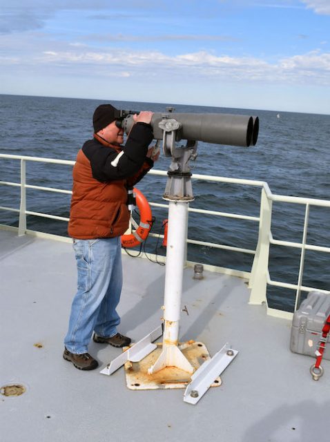
In addition to the Ocean Observatories Initiative’s (OOI) operations, a team from OSNAP (Overturning in the Subpolar North Atlantic Program) also will be onboard to recover and deploy four moorings, conduct CTD casts and water sampling at the mooring sites, and conduct additional instrument field validation tests to ensure the quality of the data collected. A participant from the National Oceanic and Atmospheric Administration will also be on board using Big Eyes binoculars mounted on a forward deck to make observations of marine mammals during the transit and in the Irminger Sea.
[media-caption path="/wp-content/uploads/2022/06/big_eyes.jpg" link="#"]Large, deck-mounted binoculars known as “big eyes” are used for marine mammal observations. NOAA Research Wildlife Biologist Peter Duley will be onboard the R/V Neil Armstrong watching for marine life in the Irminger Sea. Photo: Al Plueddemann ©WHOI.[/media-caption]
“Measurements in this remote ocean region are critical to increasing understanding of changes occurring in the ocean,” said Al Plueddemann, head of the OOI Coastal and Global Scale Nodes, which operates the OOI Global Irminger Sea Array. “It’s great to have a collaborative effort with OSNAP in this important area and an opportunity to learn more about marine life during this month-long expedition.”
Read MoreTrina Litchendorf: A Wealth of Sea-going and Engineering Experience
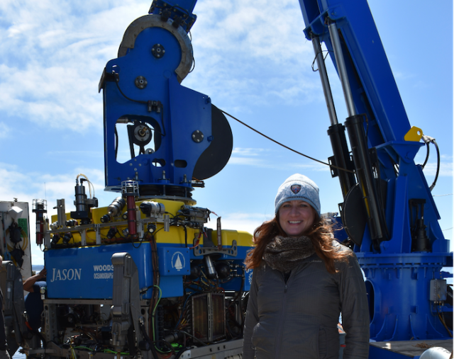
Trina Litchendorf is a highly experienced member of the Regional Cabled Array (RCA) team with a wealth of sea-going and engineering experience. She’s been with the Applied Physics Laboratory (APL) at the University of Washington (UW) since 2001. She started there as an intern through a NASA sponsorship, and stayed on while getting a degree in chemical oceanography at the UW. After graduation, she remained at APL, where she has been involved in keeping ocean observing instrumentation operational ever since. She has been working specifically on RCA instruments since 2013. She was onboard for the first deployment of cabled array instrumentation in 2014, and has served as a key part of every annual expedition since.
[media-caption path="/wp-content/uploads/2022/06/Trina-1.png" link="#"]Trina Litchendorf in front of the ROVJason. Credit: University of Washington.[/media-caption]
Trina’s duties at APL and for the RCA vary by the season. During the spring and early summer, she is actively engaged in testing and building RCA components so that they are ready for the annual Operations and Maintenance cruise. These cruises usually take place in August when undergraduate students join RCA team members at sea as part of the VISIONS at-sea experiential learning program to recover and deploy the infrastructure and instruments that the cable powers.
Each instrument undergoes three rounds of testing. The first is in the winter after the recovered instruments have been refurbished. Each is put through a rigorous round of testing, with a 12-page document of things to check. These procedures cover everything from checking for ground faults to prevent instruments from shorting out in saltwater, to placing them in a large salt water tank to simulate deployment conditions to ensure they work under such conditions. The instruments are also put through a pressure test to simulate seafloor conditions, followed by full functionality testing.
The second and third tests happen directly before the annual cruise and prior to deployment. “The second test is an integration test in the lab. We attach the instruments on the platforms on which they will be deployed to make sure that we can communicate with them and operate them through the platform. Once this test is complete, we are ready for the third, which happens onboard the ship during the annual expedition.” Onboard, she conducts a final test, connecting to the platform again to make sure all the instruments are working before anything goes into the water. She also is ready with spare and replacement parts should anything go awry during this final test.
During the expedition, Trina also directs remotely operated vehicle (ROV) dives, which serves as the eyes, ears, and hands of the underwater operation. She sits in the “hot seat” next to the ROV pilot where she directs activities on the seafloor and in the water column. The pilot manipulates the ROV to execute myriad complex operations she directs. Every platform is a little different so it is necessary to follow a prescribed dive plan to make sure every task is completed in the order in which it is supposed to happen. The complexity of these dives makes for some long days. “Typical dives run anywhere from 3-12 hours or more, and I usually end up pulling one or two 24-hour days while I’m at sea.”
“We have to get all of our gear on the seafloor plugged in and operational and last year’s gear up and off the seafloor,” Trina explained. “We have so much equipment that there’s not enough deck space for all of it, so we break the cruises up into multiple legs to load the next batch of equipment and offload the recovered gear. As a result, these cruises last anywhere from five to six or more weeks.” She’s currently getting ready to depart on VISIONS 22 in August, which because of its scope, is six weeks long and will be conducted in five legs.
Once recovered, another of her jobs is to photograph the platform and instruments’ condition, before helping with clean up, scraping of sea life that has colonized instruments and platforms, and removing a years-worth of additional biofouling.
[media-caption path="/wp-content/uploads/2022/06/students_20190622_171924_working.jpg.jpg" link="#"]Chris Williams, an undergraduate student at UW, helps to clean off a bioacoustics sonar package heavily covered with barnacles and anemones. Credit: UW/VISIONS’19/NSF/OOI.[/media-caption]
In the fall, after the cruise is over, Trina’s responsibilities turn to refurbishment and readying the instruments their next deployment. This, too, is a big job. There are close to 150 instruments deployed on more than 30 different types of platforms. The platforms range from junction boxes on the seafloor that serve as power sources for many instruments to benthic experimental packages with their own suite of instruments to shallow and deep-water profilers that move instruments up and down through the water column to sample at various depths. Her task is to ensure that recovered instruments are cleaned, taken apart, and refurbished. Most of the instruments are sent off to vendors for refurbishment and recalibration. The ultimate objective is to ensure that all of the instruments are working and that high quality data are being streamed from the RCA for community use.
The winter, into spring is spent testing and putting the platforms and instruments back together again in preparation for the upcoming cruise as the cycle begins again.
Trina’s favorite part of her job is her time at sea, particularly the time she spends in the control van with the ROV team. There she also runs the science camera, which gives her an inside look into a world few others have the opportunity to see. “I’m seeing things that most people only get to see on the Discovery Channel or National Geographic. It really is a great privilege to be part of that.”
And, she sees the cabled array as a vision realized. “I remember Dr. John Delaney telling us (during one of her undergraduate oceanography classes) about this idea he had to put a large cable in the water to power multiple seafloor sensors to study the ocean and that the whole paradigm of how oceanographic research was conducted was going to change. He saw it as moving from the old model of going out to sea on research vessels for just a few weeks at a time to collect data, to having a 24/7 365–day presence on the seafloor and throughout the water column streaming data in real time to scientists all over the world. And here I am now, actually doing this work and helping this science happen. It’s amazing,” she concluded.
Read More
OOI Designated as a UN Ocean Decade Endorsed Project
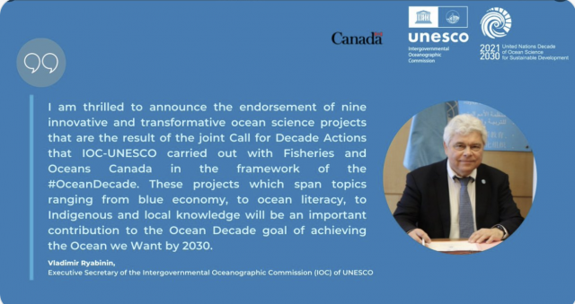
On June 8, 2022, World Oceans Day, the United Nations Educational, Scientific and Cultural Organization (UNESCO) designated the Ocean Observatories Initiative (OOI) as a UN Endorsed Action as part of the UN Decade of Ocean Science for Sustainable Development 2021-2030 (The Ocean Decade). Endorsed status presents opportunities for wider collaboration and enhanced ability to tackle grand challenges in better understanding the ocean. The announcement was timed to add to global celebrations of the UN World Oceans Day, which was organized this year around the theme “Revitalization: Collective Action for the Ocean.”
With the aim of achieving the Ocean Decade vision of “The science we need for the ocean we want,” the newly endorsed Decade Actions address priority issues worldwide, including marine pollution, management and restoration of marine ecosystems and the ocean-climate nexus—all with the goal of achieving a better understanding of the ocean system, and of delivering science-based solutions to inform decision-making from the international to the individual level.
“We are delighted that the importance of OOI’s data contributions to improving understanding of the changing ocean was recognized by the UN Decade. We very much look forward to broader opportunities to share our data with global colleagues,” said OOI Principal Investigator James B. Edson, lead of OOI’s Program Office at Woods Hole Oceanographic Institution (WHOI). WHOI operates OOI in partnership with the University of Washington and Oregon State University.
“The themes and objectives of the UN Decade of Ocean Science are tailor-made for scientists, engineers, and technicians who access OOI measurements to advance the state of our knowledge in ways that will ensure a long-term, sustainable path for society and a thriving, healthy ocean. For the coming decade and beyond, our goal is to make the ocean more accessible and to turn what we learn into meaningful, actionable information available to all,” added Edson.
Funded by the National Science Foundation, OOI was designed as a long-term project to collect ocean data for up to 25 years or more. This longevity makes it possible to measure and directly observe both short-lived episodic events and longer-term changes occurring in the ocean. Such data makes it possible to better understand ocean processes that support society and ecosystems and how the ocean is changing.
About the Ocean Decade
Proclaimed in 2017 by the United Nations General Assembly, the UN Decade of Ocean Science for Sustainable Development (2021-2030) (‘the Ocean Decade’) seeks to stimulate ocean science and knowledge generation to reverse the decline of the state of the ocean system and catalyze new opportunities for sustainable development of this massive marine ecosystem. The vision of the Ocean Decade is ‘the science we need for the ocean we want’. The Ocean Decade provides a convening framework for scientists and stakeholders from diverse sectors to develop the scientific knowledge and the partnerships needed to accelerate and harness advances in ocean science to achieve a better understanding of the ocean system, and deliver science-based solutions to achieve the 2030 Agenda. The UN General Assembly mandated UNESCO’s Intergovernmental Oceanographic Commission (IOC) to coordinate the preparations and implementation of the Decade.
About the IOC-UNESCO
The Intergovernmental Oceanographic Commission of UNESCO (IOC-UNESCO) promotes international cooperation in marine sciences to improve management of the ocean, coasts and marine resources. The IOC enables its 150 Member States to work together by coordinating programs in capacity development, ocean observations and services, ocean science and tsunami warning. The work of the IOC contributes to the mission of UNESCO to promote the advancement of science and its applications to develop knowledge and capacity, key to economic and social progress, the basis of peace and sustainable development.
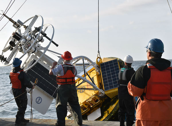
Station Papa Collaborative Expedition Completed
Ten scientists and engineers. Nineteen days at sea. Approximately 620 nautical miles offshore in the Gulf of Alaska. Six successful mooring deployments — three for the Ocean Observatories Initiative (OOI), two for the National Oceanic and Atmospheric Administration (NOAA), and one for the University of Washington (UW).
The Station Papa 9 team aboard the R/V Sikuliaq demobilized in Seattle, Washington on May 31 after a 19-day expedition to the Global Station Papa Array, in the Gulf of Alaska. In addition to the recovery and deployment of three OOI moorings (Global Hybrid Profiler, two Global Flanking Moorings), the team successfully completed two mooring recoveries and deployments for NOAA (a surface mooring and noise reference station) and UW (a Waverider, which measures surface waves). The team also carried out shipboard underway sampling, including collection of water samples, to support field calibration and validation of the platforms and sensors in the array.
[media-caption path="/wp-content/uploads/2022/05/Picture1.png" link="#"]The Station Papa moorings are outfitted with instruments that measure conductivity, temperature and depth, (CTD) dissolved oxygen, pH, fluorescence, acoustic backscatter (for characterizing zooplankton), and ocean currents. The Hybrid Profiler Mooring contains two Wire-Following Profilers that house instrumentation. The Wire-Following Profiler moves through the water column along the mooring riser, sampling ocean characteristics at a high vertical resolution over a specified depth interval (310-2,100 meters and 2,100-4000 meters deep). The flanking mooring contain instruments fixed at specific depths along the mooring riser to a depth of 1,500 meters.[/media-caption]
“The OOI Station Papa Array was designed knowing that other groups were already contributing substantial assets to the site” said Al Plueddemann, Principal Investigator of the Coastal and Global Scale Nodes (CGSN). “Seeing this collaborative observing effort come together in one joint expedition was gratifying”.
To successfully move around a significant amount of ocean observing equipment involved in six deployments, the team conducted the operation in two stages. The team first deployed the moorings that were loaded onboard the Sikuliaq at Seward, and then retraced their steps to recover the moorings that had been in the water for over a year. (OOI’s global arrays are only turned annually).
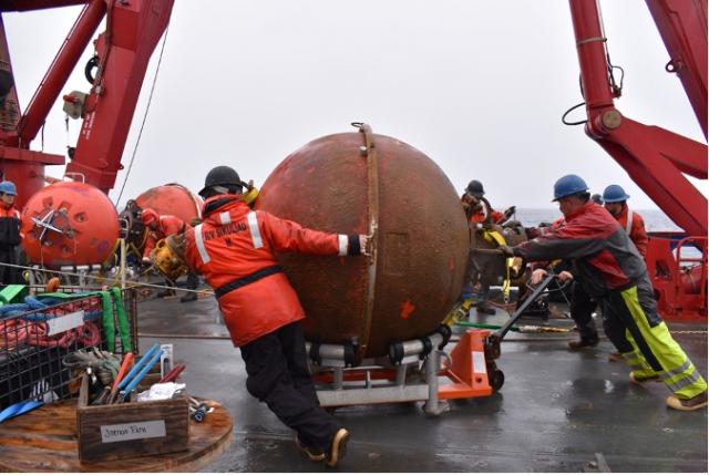
[media-caption path="/wp-content/uploads/2022/05/Picture3-1.png" link="#"]The subsurface moorings at Station Papa have various components all important for the collection of scientific data. The orange spheres provide buoyancy to keep the mooring vertical and instruments at the desired depth. Shown here is the recovery of one of these flotation spheres. Credit: Rebecca Travis ©WHOI.[/media-caption]
Station Papa 9 is the second of three nearly back-to-back recovery and deployment expeditions by OOI’s Coastal and Global Scale Node (CGSN) team this spring. The first was a Pioneer Array expedition, with two legs spanning 8-29 April. The expedition to Station Papa was next. The third after Station Papa is a nearly month-long expedition to the Irminger Sea Array, which will leave the dock in Woods Hole, MA on June 20. Said CGSN Program Manager Derek Buffitt, “Once recovered equipment is brought to shore, we immediately start to tear it down, perform inspections, download data, and start the refurbishment process. Quick turnaround times like we have had this spring, can make it challenging, but our technicians and engineers are up to the task. I am very proud of the work the CGSN team performs onshore and offshore. They are experienced professionals who you can always trust to get the job done.”
More photos and information about the Station Papa 9 expedition can be found at its expedition blog page here. OOI Station Papa data are available from using a variety of access methods described here. The NOAA/PMEL surface mooring is described here, the NOAA Noise Reference Station network is described here, and the UW Waverider is described here.
Read More
Striped Bass Link OOI Pioneer Array Locations
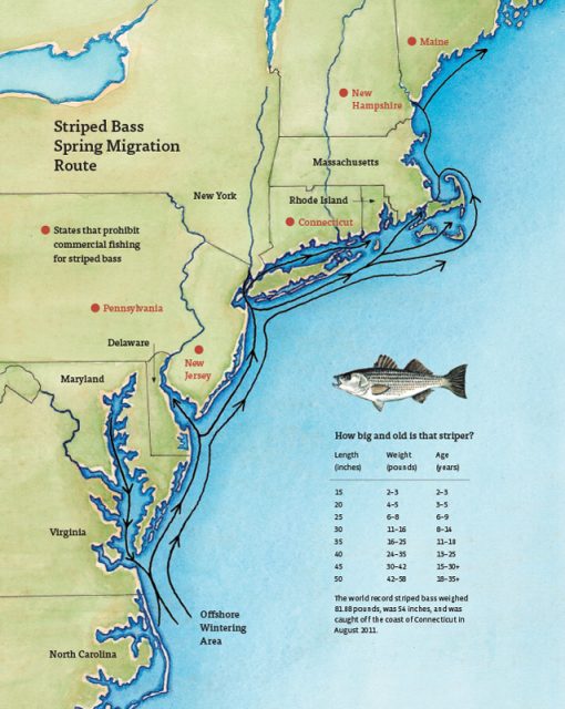
A recent article in the Martha’s Vineyard Gazette tells a fascinating tale of how fish like striped bass respond to changes in ocean conditions. The striped bass story also provides links between the current OOI Pioneer Array location on the New England Shelf (NES) and the new location in the southern Mid-Atlantic Bight (MAB).
The Northwest Atlantic has been warming due to both atmospheric and oceanographic influences (e.g., Chen et al., 2014; Gawarkiewicz et al., 2019) and the impacts can bee seen in the distribution of marine species like stripers. The stripers are typically found on the New England Shelf in the spring, with bass fishing tournaments a long-held tradition for islands like Martha’s Vineyard, Nantucket, and Cuttyhunk. But conditions are changing, and as the waters warm, the stripers appear to be moving further north. Data from the NES Pioneer Array are helping researchers and fishers understand the changes.
[media-caption path="/wp-content/uploads/2022/05/Striped-Bass-migration-map.jpg" link="#"]Striped bass spring migration route. Credit: Martha’s Vineyard Gazette and Dana Gaines Martha’s Vineyard Magazine.[/media-caption]
Stripers spawn in brackish water and spend their first few years in estuarine waters like those of the Chesapeake Bay. These waters are changing too, with earlier springs modifying spawning behavior. Understanding how environmental conditions impact the life cycle of stripers from estuary to open ocean requires knowledge of the atmosphere, continental shelf waters, and the Gulf Stream. Finally, it is necessary to investigate interactions that exchange properties between estuaries, shelf and slope sea – which will be the focus of the MAB Pioneer Array currently being planned for implementation in 2024.
References
Chen, K., G. G. Gawarkiewicz, S. J. Lentz, and J. M. Bane (2014), Diagnosing the warming of the Northeastern U.S. Coastal Ocean in 2012: A linkage between the atmospheric jet stream variability and ocean response, J. Geophys. Res. Oceans, 119, doi:10.1002/2013JC009393.
Gawarkiewicz G, Chen K, Forsyth J, Bahr F, Mercer AM, Ellertson A, Fratantoni P, Seim H, Haines S and Han L (2019), Characteristics of an Advective Marine Heatwave in the Middle Atlantic Bight in Early 2017. Front. Mar. Sci. 6:712. doi: 10.3389/fmars.2019.00712.
Schneider, P. (2022), Climate Change Clue: Follow the Stripers. Vineyard Gazette, 12 May 2022.
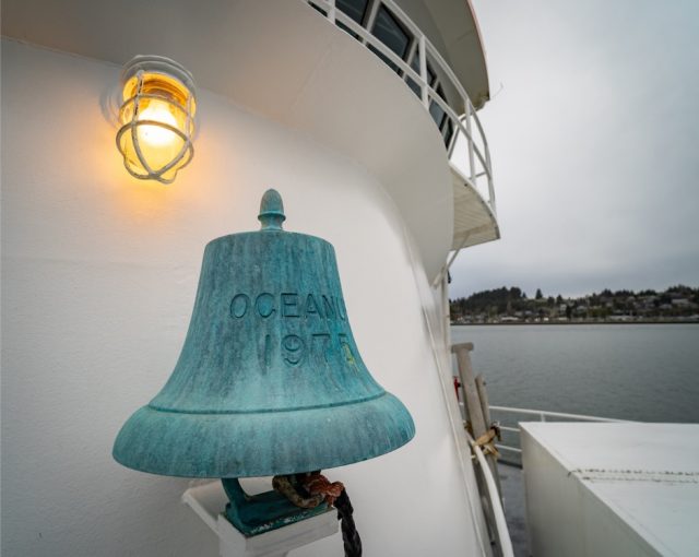
Read MoreR/V Oceanus Decommissioned and Celebrated
The R/V Oceanus was decommissioned last year, but its 45 years of service to the oceanographic community were celebrated at Oregon State University (OSU) at an event Friday May 6, 2022. The Coastal Endurance Array team used the Oceanus for many recovery and deployment expeditions before her retirement in 2021.
[media-caption path="/wp-content/uploads/2022/05/Picture1-copy.jpg" link="#"]The Oceanus was originally built in 1975 and began its work as a research vessel in 1976. Photo: OSU.[/media-caption]
[media-caption path="/wp-content/uploads/2022/05/graphics-OOI_AST2-DSC_5970.jpg" link="#"]R/V Oceanus departing WHOI on the deployment leg of OOI At-Sea Test 2 (AST-2) on September 22, 2011. Photo: Ken Kostel ©WHOI.[/media-caption]
Prior to its tenure at OSU, the Oceanus was in service at the Woods Hole Oceanographic Institution (WHOI) from 1976-2012. WHOI retired the ship and it was transferred to OSU in 2012. While at WHOI, the ship was used in early test deployments of equipment being evaluated for use in OOI arrays.
“The R/V Oceanus and its sister ship R/V Wecoma remain my favorite research vessels for air-sea interaction research due to their moderate size, uncluttered bows, and streamlined shapes,” said Jim Edson, Principal Investigator of the Ocean Observatories Initiative (OOI). “Research cruises on these vessels led to the development of the direct covariance systems we are using on the OOI surface moorings today.”
The Oceanus will be replaced with a new modern research vessel, the R/V Taani, which is expected to be delivered next year.
The Oceanus’ service in the Pacific is celebrated in this video produced by OSU:
[embed]https://vimeo.com/709661216[/embed]Video remembrance of Oceanus:
[embed]https://www.youtube.com/watch?v=YC2eHJa8Gbs[/embed]Video of departure:
[embed]https://www.youtube.com/watch?v=qRV1IG3rs1o[/embed]Read More
Successful Last Deployment of Pioneer Array on NE Shelf
The Pioneer 18 Array team and crew of the R/V Neil Armstrong pulled into the dock at Woods Hole, MA, on April 27, a day earlier than expected, having completed all objectives of the expedition. Their mission included the last deployment of the Pioneer Array at its current location on the New England Shelf. The Pioneer Array components now in the water will be recovered in November 2022 and redeployed in the Southern Mid-Atlantic Bight in the Spring of 2024.
The expedition consisted of two legs. On leg #1, three Coastal Surface Moorings and multiple gliders were recovered and deployed and autonomous vehicle missions were completed. On leg #2, the team deployed five Coastal Profiler Moorings. Three Coastal Surface Moorings and seven Coastal Profiler Moorings were recovered, two of which could not be recovered during an earlier expedition because of weather conditions. The recovered equipment will be taken apart, refurbished, and in some cases, reconfigured for deployment at the new location.
Weather conditions allowed for multiple deployments of a remotely operated vehicle, to help assess the condition and assist in the recovery of mooring components that could not be recovered by standard techniques (using an acoustically-triggered release). The team also conducted additional activities that ranged from water sampling adjacent to the moorings to cross-shelf CTD (conductivity, temperature, and depth) surveys in the vicinity of the moored array, and surveys using shipboard sensors. A variety of ancillary activities, accommodating eight participants from five different institutions, were also facilitated during the cruise.
Al Plueddemann, Principal Investigator of the Coastal and Global Scale Nodes (CGSN) and Chief Scientist of Pioneer 18 said, “The successful completion of this expedition again demonstrates the capabilities and experience of the CGSN team and the R/V Armstrong, and bodes well for successful operation of the Pioneer Array in its new location in the Southern Mid-Atlantic Bight.”
[media-caption path="/wp-content/uploads/2022/05/last_NES_CPM_PMUI-17-copy.jpg" link="#"]The Coastal Profiler Mooring shown here, PMUI-17, will be the last Pioneer mooring deployed on the New England Shelf. After providing data through the summer and early fall, the current array will be recovered in November of 2022 and relocated to the Southern Mid-Atlantic Bight in 2024. Credit: Jess Kozik©WHOI.[/media-caption]
The Pioneer Array was originally commissioned in 2016 as a re-locatable coastal array suitable for moderate to high wind, wave and current regimes on the continental shelf and upper slope. The new location in the Southern Mid-Atlantic Bight was decided upon after a series of workshops in 2021, co-sponsored by the National Science Foundation and the Ocean Observatories Initiative Facility Board, to gain community input on a new location that would best address pressing science questions.
Plueddemann added, “The Pioneer Array has collected a remarkable data set from the New England Shelf, which scientists will continue to use to understand frontal dynamics and related ecosystem impacts in this important and dynamic region.”
[media-caption path="/wp-content/uploads/2022/05/heads_up-copy.jpg" link="#"]When the large Coastal Surface Mooring buoys are recovered everyone pays close attention. The buoy tower spins when the hull is picked out of the water, and the deck team needs to be ready with a snap hook to clip into the circular rails on the tower top and arrest the motion. Credit: Andrew Reed ©WHOI.[/media-caption]
As the Pioneer 18 team headed home, another CGSN expedition is about to hit the water. A team of scientists and engineers is already traveling to Seward, Alaska to mobilize for another OOI expedition. On May 12, they will be aboard the R/V Sikuliaq for a 19-day expedition to the Global Station Papa Array, in the Gulf of Alaska, about 620 nautical miles offshore. This team will deploy five moorings — three for OOI and one each for the National Oceanic and Atmospheric Administration and the University of Washington. Once on site, the team will first deploy the moorings onboard, then recover those that have been in the water for a year. Upon completion, the ship will transit to the demobilization port of Seattle, Washington. Bookmark this site, and follow along on their progress.
Read MoreWHOI hosts MME Annual Meeting
The Massachusetts Marine Educators Association (MME) 46th Annual Meeting was held at Woods Hole Oceanographic Institution (WHOI) on Saturday April 30th. The event, sponsored by WHOI and Woods Hole Sea Grant, provided an opportunity for educators to get together in person, tour WHOI’s facilities, and learn about how ocean and coastal data can be used in the classroom.
WHOI and Ocean Observatories Initiative (OOI) Engineer Sheri White gave one of the keynote addresses: “The Ocean Observatories Initiative:Collecting Long-Term Coastal and Global Time Series Data.” She followed this with a tour to a group of about 15 people of OOI’s lab and equipment testing and holding area at LOSOS and of some recovered Pioneer Array gear.
[media-caption path="/wp-content/uploads/2022/05/IMG_0498-rotated.jpg" link="#"]WHOI Engineer Sheri White showed participants recovered Pioneer Array gear. Photo: Stace Beaulieu©WHOI.[/media-caption]
WHOI Researcher Stace Beaulieu presented a workshop entitled “Wild Ocean Data: Easily Within Reach.” Her presentation, a tutorial on how to use OOI’s Data Explorer, is available online for those who missed it at https://tinyurl.com/WildOceanData.
[media-caption path="/wp-content/uploads/2022/05/IMG_0495-copy-2.jpg" link="#"]WHOI Researcher Stace Beaulieu showed how to use Data Explorer in the classroom. Photo: Annette Brickley.[/media-caption]
Rounding out the day was a presentation by Education Specialist by Annette Brickley, who presented “Is it Data? or Is it Cake?” She talked about the NES-LTER Data Jam and what students can do with NES-LTER and OOI Data.
[media-caption path="/wp-content/uploads/2022/05/IMG_0997-2-scaled.jpg" link="#"]Education Specialist Annette Brickley presented: Is it Data? Or is it cake? Photo: Stace Beaulieu ©WHOI.[/media-caption]
Read More