
CE02SHSM
The Coastal Endurance Oregon Shelf Surface Mooring is located on the Continental Shelf, approximately 80 meters deep. The Continental Shelf-Slope area off the Oregon coast is a highly productive, dynamic upwelling environment.
Platform DOI and Citation Guidance
OOI assigns Digital Object Identifiers (DOIs) at the platform or site level. The DOI for the Coastal Endurance Oregon Shelf Surface Mooring is 10.58046/OOI-CE02SHSM.
The minimum recommended citation for this platform is:
NSF Ocean Observatories Initiative. (2015). Coastal Endurance Oregon Shelf Surface Mooring, DOI: 10.58046/OOI-CE02SHSM.
This follows the format NSF Ocean Observatories Initiative. (Year Published). Platform title, DOI: Platform DOI, where Year Published is the year OOI data collection began at the site.
We encourage data users to incorporate full citations when referencing OOI data in order to support FAIR data principles and data traceability. OOI also provides further guidance on citations, including information on adding specific data products and data access points to citations.
Data Access
The following links provide data access via Data Explorer or other methods:
- Direct access to the data on this platform and its subcomponents
- General access to OOI data using a variety of methods
Platform Description
The Coastal Endurance Oregon Shelf Surface Mooring is located on the Continental Shelf, approximately 80 meters deep. The Continental Shelf-Slope area off the Oregon coast is a highly productive, dynamic upwelling environment. Upwelling brings nutrients to the surface sparking primary production and fueling the food web. In recent years, upwelling has also brought onto the shelf hypoxic, low oxygen, waters that can be harmful to organisms in the area. By sampling in this area, the OOI seeks to gain better insight into upwelling dynamics of this system.
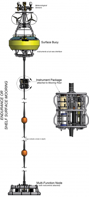
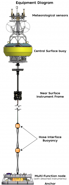
Like other coastal moorings, the Coastal Endurance Oregon Shelf Surface Mooring is specifically designed to examine coastal-scale phenomena and withstand the challenging conditions of shallow coastal environments, including large tidal fluctuations. The Surface Mooring contains instruments attached to a Surface Buoy floating on the sea surface, Near Surface Instrument Frame 7 meters below the surface, and a Seafloor Multi-Function Node (MFN) located on the seafloor. The Surface Buoy provides a platform on which to secure surface instruments above the sea surface, below the sea surface, and across the interface between. Additionally the Surface Buoy contains an antenna to transmit data to shore via satellite.
Read MoreCE04OSBP
The Oregon Offshore Cabled Benthic Experiment Package (BEP) is located on the Continental Slope, approximately 550 meters deep. The Continental Shelf-Slope area off the Oregon coast is a highly productive, dynamic upwelling environment.
Platform DOI and Citation Guidance
OOI assigns Digital Object Identifiers (DOIs) at the platform or site level. The DOI for the Oregon Offshore Cabled Benthic Experiment Package is 10.58046/OOI-CE04OSBP.
The minimum recommended citation for this platform is:
NSF Ocean Observatories Initiative. (2014). Oregon Offshore Cabled Benthic Experiment Package, DOI: 10.58046/OOI-CE04OSBP.
This follows the format NSF Ocean Observatories Initiative. (Year Published). Platform title, DOI: Platform DOI, where Year Published is the year OOI data collection began at the site.
We encourage data users to incorporate full citations when referencing OOI data in order to support FAIR data principles and data traceability. OOI also provides further guidance on citations, including information on adding specific data products and data access points to citations.
Data Access
The following links provide data access via Data Explorer or other methods:
- Direct access to the data on this platform and its subcomponents
- General access to OOI data using a variety of methods
Platform Description
Oregon Offshore Cabled Benthic Experiment Package (BEP) is located on the Continental Slope, approximately 550 meters deep. The Continental Shelf-Slope area off the Oregon coast is a highly productive, dynamic upwelling environment. Upwelling brings nutrients to the surface sparking primary production and fueling the food web. In recent years, upwelling has also brought onto the shelf hypoxic, low oxygen, waters that can be harmful to organisms in the area. By sampling in this area, the OOI seeks to gain better insight into upwelling dynamics of this system.
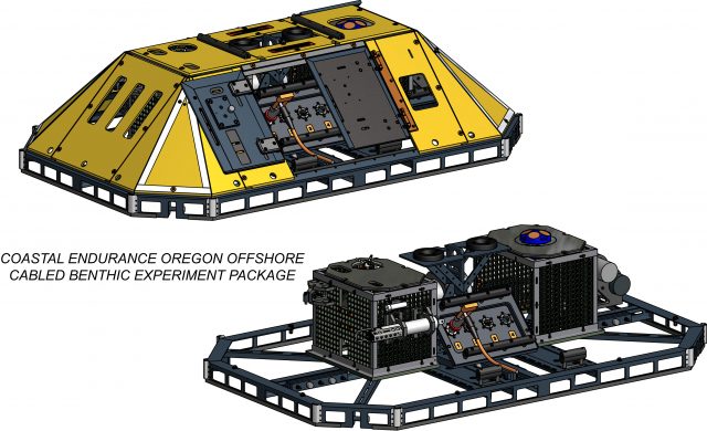
Like other BEPs the Oregon Offshore Cabled BEP is connected to and draws energy from Fiber Optic Cables to power its instruments and to transmit data from the instruments back to shore. Within the yellow protective armor of the BEP are two cages containing instruments that measure various properties of the bottom water.
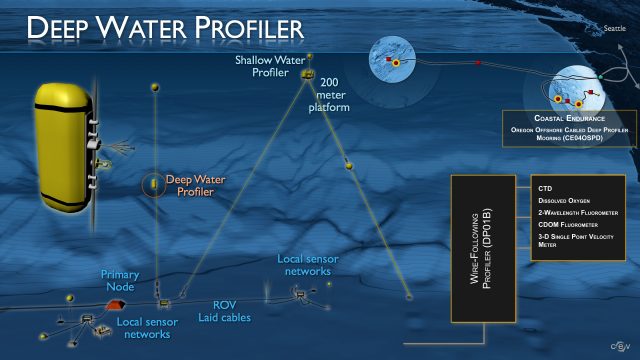
The Oregon Offshore Cabled BEP is located near the base of a shallow and deep profiler mooring providing complementary seafloor data to the water column data collected by the profilers, allowing for the sampling of a full picture of shelf dynamics.
Read MoreCE04OSPD
Oregon Offshore Cabled Deep Profiler Mooring is located on the Continental Slope, approximately 550 meters deep. The Continental Shelf-Slope area off the Oregon coast is a highly productive, dynamic upwelling environment.
Platform DOI and Citation Guidance
OOI assigns Digital Object Identifiers (DOIs) at the platform or site level. The DOI for the Oregon Offshore Cabled Deep Profiler Mooring is 10.58046/OOI-CE04OSPD.
The minimum recommended citation for this platform is:
NSF Ocean Observatories Initiative. (2014). Oregon Offshore Cabled Deep Profiler Mooring, DOI: 10.58046/OOI-CE04OSPD.
This follows the format NSF Ocean Observatories Initiative. (Year Published). Platform title, DOI: Platform DOI, where Year Published is the year OOI data collection began at the site.
We encourage data users to incorporate full citations when referencing OOI data in order to support FAIR data principles and data traceability. OOI also provides further guidance on citations, including information on adding specific data products and data access points to citations.
Data Access
The following links provide data access via Data Explorer or other methods:
- Direct access to the data on this platform and its subcomponents
- General access to OOI data using a variety of methods
Platform Description
The Oregon Offshore Cabled Deep Profiler Mooring is located on the Continental Slope, approximately 550 meters deep. The Continental Shelf-Slope area off the Oregon coast is a highly productive, dynamic upwelling environment. Upwelling brings nutrients to the surface sparking primary production and fueling the food web. In recent years, upwelling has also brought onto the shelf hypoxic, low oxygen, waters that can be harmful to organisms in the area. By sampling in this area, the OOI seeks to gain better insight into upwelling dynamics of this system.
As with other Cabled Deep Profiler Moorings, this mooring contains a Wire-Following Profiler and is attached to a fiber-optic cable. The Wire-Following Profiler houses scientific instrumentation and moves through the water column along the mooring riser, continuously sampling ocean characteristics over a specified depth interval (175 meters below sea surface to near bottom). The fiber-optic cable provides the mooring with a large supply of power and bandwidth and is co-located with a Benthic Experiment Package, that collects complementary seafloor data.
Read MoreCP02PMUI
The Coastal Pioneer New England Shelf Upstream Inshore Profiler Mooring is located on the inner Continental Shelf (approximately 90 m deep), east (i.e., upstream) of the other Moorings. The Continental Shelf-Slope area off the New England coast is a highly productive area and one that is located at a dynamic intersection where ocean currents meet in weather-like “fronts,” and where nutrients, pollutants, and other properties are exchanged between the coast and the deep ocean.
Platform DOI and Citation Guidance
OOI assigns Digital Object Identifiers (DOIs) at the platform or site level. The DOI for the Coastal Pioneer New England Shelf Upstream Inshore Profiler Mooring is 10.58046/OOI-CP02PMUI.
The minimum recommended citation for this platform is:
NSF Ocean Observatories Initiative. (2013). Coastal Pioneer New England Shelf Upstream Inshore Profiler Mooring, DOI: 10.58046/OOI-CP02PMUI.
This follows the format NSF Ocean Observatories Initiative. (Year Published). Platform Title, DOI: Platform DOI, where Year Published is the year OOI data collection began at the site.
We encourage data users to incorporate full citations when referencing OOI data in order to support FAIR data principles and data traceability. OOI also provides further guidance on citations, including information on adding specific data products and data access points to citations.
Data Access
The following links provide data access via Data Explorer or other methods:
- Direct access to the data on this platform and its subcomponents
- General access to OOI data using a variety of methods
Platform Description
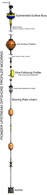
The Pioneer NES Upstream Inshore Profiler Mooring is located on the inner Continental Shelf (approximately 90 m deep), east (i.e., upstream) of the other Moorings. The Continental Shelf-Slope area off the New England coast is a highly productive area and one that is located at a dynamic intersection where ocean currents meet in weather-like “fronts,” and where nutrients, pollutants, and other properties are exchanged between the coast and the deep ocean. Data from the inner shelf area help to examine exchanges between the shelf and slope and the shelf ecosystem, as well as provide broader insight into the issues of air-sea gas exchange, including Carbon Dioxide.
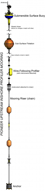
Like other Coastal Profiler Moorings, the Pioneer NES Upstream Inshore Profiler Mooring contains a Wire-Following Profiler that houses instruments. The Wire-Following Profiler moves through the water column along the mooring riser, continuously sampling ocean characteristics over a specified depth interval.
Read MoreCP02PMUO
The Coastal Pioneer New England Shelf Upstream Offshore Profiler Mooring is located on the Continental Slope (approximately 450 m deep), east (i.e., upstream) of the other Moorings. The Continental Shelf-Slope area off the New England coast is a highly productive area and one that is located at a dynamic intersection where ocean currents meet in weather-like “fronts,” and where nutrients, pollutants, and other properties are exchanged between the coast and the deep ocean.
Platform DOI and Citation Guidance
OOI assigns Digital Object Identifiers (DOIs) at the platform or site level. The DOI for the Coastal Pioneer New England Shelf Upstream Offshore Profiler Mooring is 10.58046/OOI-CP02PMUO.
The minimum recommended citation for this platform is:
NSF Ocean Observatories Initiative. (2013). Coastal Pioneer New England Shelf Upstream Offshore Profiler Mooring, DOI: 10.58046/OOI-CP02PMUO.
This follows the format NSF Ocean Observatories Initiative. (Year Published). Platform Title, DOI: Platform DOI, where Year Published is the year OOI data collection began at the site.
We encourage data users to incorporate full citations when referencing OOI data in order to support FAIR data principles and data traceability. OOI also provides further guidance on citations, including information on adding specific data products and data access points to citations.
Data Access
The following links provide data access via Data Explorer or other methods:
- Direct access to the data on this platform and its subcomponents
- General access to OOI data using a variety of methods
Platform Description
The Pioneer NES Upstream Offshore Profiler Mooring is located on the Continental Slope (approximately 450 m deep), east (i.e., upstream) of the other Moorings. The Continental Shelf-Slope area off the New England coast is a highly productive area and one that is located at a dynamic intersection where ocean currents meet in weather-like “fronts,” and where nutrients, pollutants, and other properties are exchanged between the coast and the deep ocean. Data from the offshore slope area help to examine exchanges between the shelf and slope and the shelf ecosystem, as well as provide broader insight into the issues of air-sea gas exchange, including Carbon Dioxide.
Like other Coastal Profiler Moorings, the Pioneer NES Upstream Offshore Profiler Mooring contains a Wire-Following Profiler that houses instruments. The Wire-Following Profiler moves through the water column along the mooring riser, continuously sampling ocean characteristics over a specified depth interval.
Read MoreCE09OSPM
The Coastal Endurance Washington Offshore Profiler Mooring is located on the Continental Slope, approximately 550 meters deep. The Continental Shelf-Slope area off the Washington coast is a highly productive, dynamic upwelling environment.
Platform DOI and Citation Guidance
OOI assigns Digital Object Identifiers (DOIs) at the platform or site level. The DOI for the Coastal Endurance Washington Offshore Profiler Mooring is 10.58046/OOI-CE09OSPM.
The minimum recommended citation for this platform is:
NSF Ocean Observatories Initiative. (2014). Coastal Endurance Washington Offshore Profiler Mooring, DOI: 10.58046/OOI-CE09OSPM.
This follows the format NSF Ocean Observatories Initiative. (Year Published). Platform title, DOI: Platform DOI, where Year Published is the year OOI data collection began at the site.
We encourage data users to incorporate full citations when referencing OOI data in order to support FAIR data principles and data traceability. OOI also provides further guidance on citations, including information on adding specific data products and data access points to citations.
Data Access
The following links provide data access via Data Explorer or other methods:
- Direct access to the data on this platform and its subcomponents
- General access to OOI data using a variety of methods
Platform Description
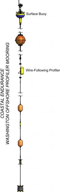
The Coastal Endurance Washington Offshore Profiler Mooring is located on the Continental Slope, approximately 550 meters deep. The Continental Shelf-Slope area off the Washington coast is a highly productive, dynamic upwelling environment. Upwelling brings nutrients to the surface sparking primary production and fueling the food web. In recent years, upwelling has also brought onto the shelf hypoxic, low oxygen, waters that can be harmful to organisms in the area. By sampling in this area, the OOI seeks to gain better insight into upwelling dynamics of this system.
Like other Coastal Profiler Moorings, the Endurance Washington Offshore Profiler Mooring contains a Wire-Following Profiler that houses instruments. The Wire-Following Profiler moves through the water column along the mooring riser, continuously sampling ocean characteristics over a specified depth interval (15 meters below sea surface to 3 m above the bottom).
Read MoreGA02HYPM
The Global Argentine Basin Apex Profiler Mooring is co-located with Apex Surface Mooring. Additionally, at the Argentine Basin site are two identical Flanking Subsurface that make up the equidistant sides of a triangle of Moorings (62 km) from the co-located Profiler and Surface Moorings.
Platform DOI and Citation Guidance
OOI assigns Digital Object Identifiers (DOIs) at the platform or site level. The DOI for the Global Argentine Basin Apex Profiler Mooring is 10.58046/OOI-GA02HYPM.
The minimum recommended citation for this platform is:
NSF Ocean Observatories Initiative. (2015). Global Argentine Basin Apex Profiler Mooring, DOI: 10.58046/OOI-GA02HYPM.
This follows the format NSF Ocean Observatories Initiative. (Year Published). Platform title, DOI: Platform DOI, where Year Published is the year OOI data collection began at the site.
We encourage data users to incorporate full citations when referencing OOI data in order to support FAIR data principles and data traceability. OOI also provides further guidance on citations, including information on adding specific data products and data access points to citations.
Data Access
The following links provide data access via Data Explorer or other methods:
- Direct access to the data on this platform and its subcomponents
- General access to OOI data using a variety of methods
Platform Description
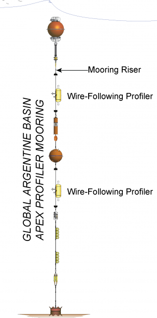
The Global Argentine Basin Apex Profiler Mooring is co-located with Apex Surface Mooring. Additionally, at the Argentine Basin site are two identical Flanking Subsurface that make up the equidistant sides of a triangle of Moorings (62 km) from the co-located Profiler and Surface Moorings. The Profiler Mooring is located in 5,200 meters of water along the Brazil Current in the South Atlantic. The triangular configuration moorings provide unique spatial array through which instruments fixed to moorings continuously collect data through time and gliders sample the area between the moorings. The Argentine Basin site is one of four high latitude open ocean locations in the OOI that provide observations to gain better insight into global ocean circulation and climate.
Like other Apex Profiler Moorings, the Argentine Basin Apex Profiler Mooring contains two Wire-Following Profilers that house instrumentation. The Wire-Following Profiler moves through the water column along the mooring riser, continuously sampling ocean characteristics at a high vertical resolution over a specified depth interval (310-2,445 meters and 2,470-4605 meters deep).
Read MoreGA01SUMO
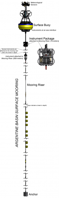
The Argentine Basin Apex Surface Mooring is specifically designed to provide key insights into climate dynamics as well as withstand rough sea conditions.
Read MoreCP05MOAS
The Coastal Pioneer New England Shelf Mobile Assets are an array of 6 Coastal Gliders (Teledyne-Webb Slocum Gliders) that sample large, mesoscale features through a broad region (130 x 185 km) of the outer continental shelf between the shelf break and the Gulf Stream. The role of these gliders in monitoring this broader area is to resolve rings, eddies and meanders from the Gulf Stream as they impinge on the shelf break front.
Platform DOI and Citation Guidance
OOI assigns Digital Object Identifiers (DOIs) at the platform or site level. The DOI for the Coastal Pioneer New England Shelf Mobile Assets is 10.58046/OOI-CP05MOAS.
The minimum recommended citation for this platform is:
NSF Ocean Observatories Initiative. (2014). Coastal Pioneer New England Shelf Mobile Assets, DOI: 10.58046/OOI-CP05MOAS.
This follows the format NSF Ocean Observatories Initiative. (Year Published). Platform title, DOI: Platform DOI, where Year Published is the year OOI data collection began at the site.
We encourage data users to incorporate full citations when referencing OOI data in order to support FAIR data principles and data traceability. OOI also provides further guidance on citations, including information on adding specific data products and data access points to citations.
Data Access
The following links provide data access via Data Explorer or other methods:
- Direct access to the data on this platform and its subcomponents
- General access to OOI data using a variety of methods
Platform Description
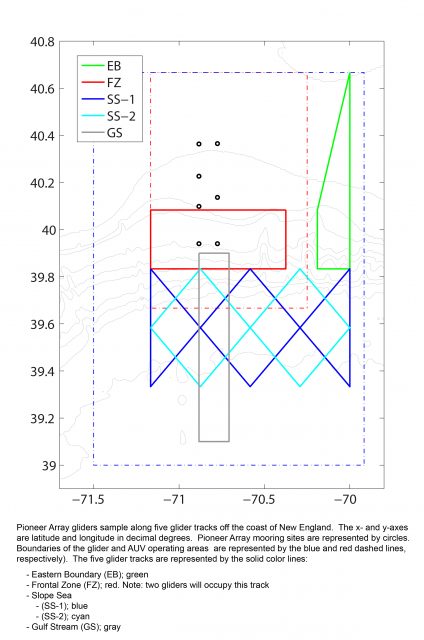
Two kinds of Mobile Assets survey the area in and around the array of moorings at the Coastal Pioneer NES Array – Coastal Gliders and Coastal Autonomous Underwater Vehicles (AUVs).
[twocol_one]
Approximate Glider sampling area boundaries:
SE: 39.00°N, 69.92°W
SW: 39.00°N, 71.50°W
NW: 40.67°N, 71.50°W
NE: 40.67°N, 69.92°W
[/twocol_one]
[twocol_one_last]
Approximate AUV sampling area boundaries:
SE: 39.67°N, 70.25°W
SW: 39.67°N, 71.17°W
NW: 40.67°N, 71.17°W
NE: 40.67°N, 70.25°W
[/twocol_one_last]
An array of 6 Coastal Gliders (Teledyne-Webb Slocum Gliders) sample large, mesoscale features through a broad region (130 x 185 km) of the outer continental shelf between the shelf break and the Gulf Stream. The role of these gliders in monitoring this broader area is to resolve rings, eddies and meanders from the Gulf Stream as they impinge on the shelf break front. These Teledyne-Webb Slocum Gliders fly through the water column along saw-tooth paths, penetrating the sea surface and diving down to a maximum depth of 1000 meters.
An array of two Coastal AUVs (REMUS-600 AUVs) travel along transects across the shelf-break frontal system extending beyond the mooring array, covering an area approximately 80 x 100 km in size centered on the array of moorings. The primary role of the AUVs is to resolve cross- and along-front “eddy fluxes” due to frontal instabilities, wind forcing, and mesoscale variability. These AUVs travel along saw-toothed transects, penetrating the sea surface and diving down to a maximum depth of 600 meters.
Read MoreCP04OSSM
The Coastal Pioneer New England Shelf Offshore Surface Mooring is located on the Continental Slope approximately 450 meters deep. The Continental Shelf-Slope area off the New England coast is a highly productive area and one that is located at a dynamic intersection where ocean currents meet in weather-like “fronts,” and where nutrients, pollutants, and other properties are exchanged between the coast and the deep ocean.
Platform DOI and Citation Guidance
OOI assigns Digital Object Identifiers (DOIs) at the platform or site level. The DOI for the Coastal Pioneer New England Shelf Offshore Surface Mooring is 10.58046/OOI-CP04OSSM.
The minimum recommended citation for this platform is:
NSF Ocean Observatories Initiative. (2014). Coastal Pioneer New England Shelf Offshore Surface Mooring, DOI: 10.58046/OOI-CP04OSSM.
This follows the format NSF Ocean Observatories Initiative. (Year Published). Platform title, DOI: Platform DOI, where Year Published is the year OOI data collection began at the site.
We encourage data users to incorporate full citations when referencing OOI data in order to support FAIR data principles and data traceability. OOI also provides further guidance on citations, including information on adding specific data products and data access points to citations.
Data Access
The following links provide data access via Data Explorer or other methods:
- Direct access to the data on this platform and its subcomponents
- General access to OOI data using a variety of methods
Platform Description
The Pioneer NES Offshore Surface Mooring is located on the Continental Slope approximately 450 meters deep. The Continental Shelf-Slope area off the New England coast is a highly productive area and one that is located at a dynamic intersection where ocean currents meet in weather-like “fronts,” and where nutrients, pollutants, and other properties are exchanged between the coast and the deep ocean. Data from the offshore, slope area help to examine exchanges between the shelf and slope and the shelf ecosystem, as well as provide broader insight into the issues of air-sea gas exchange, including Carbon Dioxide.
Like other coastal moorings, the Pioneer NES Offshore Surface Mooring is specifically designed to examine coastal-scale phenomena and withstand the challenging conditions of shallow coastal environments, including large tidal fluctuations. The Surface Mooring contains instruments attached to a Surface Buoy floating on the sea surface, Near Surface Instrument Frame 7 meters below the surface, and a Seafloor Multi-Function Node (MFN) located on the seafloor. The Surface Buoy provides a platform on which to secure surface instruments above the sea surface, below the sea surface, and across the interface between. Additionally the Surface Buoy contains an antenna to transmit data to shore via satellite.
Read More