
CP04OSPM

The Coastal Pioneer New England Shelf Offshore Profiler Mooring is located on the Continental Slope approximately 450 meters deep. The Continental Shelf-Slope area off the New England coast is a highly productive area and one that is located at a dynamic intersection where ocean currents meet in weather-like “fronts,” and where nutrients, pollutants, and other properties are exchanged between the coast and the deep ocean.
Platform DOI and Citation Guidance
OOI assigns Digital Object Identifiers (DOIs) at the platform or site level. The DOI for the Coastal Pioneer New England Shelf Offshore Profiler Mooring is 10.58046/OOI-CP04OSPM.
The minimum recommended citation for this platform is:
NSF Ocean Observatories Initiative. (2014). Coastal Pioneer New England Shelf Offshore Profiler Mooring, DOI: 10.58046/OOI-CP04OSPM.
This follows the format NSF Ocean Observatories Initiative. (Year Published). Platform title, DOI: Platform DOI, where Year Published is the year OOI data collection began at the site.
We encourage data users to incorporate full citations when referencing OOI data in order to support FAIR data principles and data traceability. OOI also provides further guidance on citations, including information on adding specific data products and data access points to citations.
Data Access
The following links provide data access via Data Explorer or other methods:
- Direct access to the data on this platform and its subcomponents
- General access to OOI data using a variety of methods
Platform Description
The Pioneer NES Offshore Profiler Mooring is located on the Continental Slope approximately 450 meters deep. The Continental Shelf-Slope area off the New England coast is a highly productive area and one that is located at a dynamic intersection where ocean currents meet in weather-like “fronts,” and where nutrients, pollutants, and other properties are exchanged between the coast and the deep ocean. Data from the offshore, slope area help to examine exchanges between the shelf and slope and the shelf ecosystem, as well as provide broader insight into the issues of air-sea gas exchange, including Carbon Dioxide.
Like other Coastal Profiler Moorings, the Pioneer NES Offshore Profiler Mooring contains a Wire-Following Profiler that houses instruments. The Wire-Following Profiler moves through the water column along the mooring riser, continuously sampling ocean characteristics over a specified depth interval.
Read MoreCP03ISSP
The Coastal Pioneer New England Shelf Inshore Surface Piercing Profiler Mooring is located on the inner Continental Shelf, approximately 90 meters deep. The Continental Shelf-Slope area off the New England coast is a highly productive area and one that is located at a dynamic intersection where ocean currents meet in weather-like “fronts,” and where nutrients, pollutants, and other properties are exchanged between the coast and the deep ocean.
Platform DOI and Citation Guidance
OOI assigns Digital Object Identifiers (DOIs) at the platform or site level. The DOI for the Coastal Pioneer New England Shelf Inshore Surface Piercing Profiler Mooring is 10.58046/OOI-CP03ISSP.
The minimum recommended citation for this platform is:
NSF Ocean Observatories Initiative. (2015). Coastal Pioneer New England Shelf Inshore Surface Piercing Profiler Mooring, DOI: 10.58046/OOI-CP03ISSP.
This follows the format NSF Ocean Observatories Initiative. (Year Published). Platform title, DOI: Platform DOI, where Year Published is the year OOI data collection began at the site.
We encourage data users to incorporate full citations when referencing OOI data in order to support FAIR data principles and data traceability. OOI also provides further guidance on citations, including information on adding specific data products and data access points to citations.
Data Access
The following links provide data access via Data Explorer or other methods:
- Direct access to the data on this platform and its subcomponents
- General access to OOI data using a variety of methods
Platform Description
[box type="note"]In the fall of 2015, deployments of the Coastal Surface Piercing Profiler (CSPP) Moorings at the Pioneer NES Array were suspended. In the spring of 2016 the Program approved the use of Coastal Profiling Gliders in the summer and Profiler Moorings in the winter at the sites previously occupied by CSPPs.[/box]The Pioneer NES Inshore Surface Piercing Profiler Mooring is located on the inner Continental Shelf, approximately 90 meters deep. The Continental Shelf-Slope area off the New England coast is a highly productive area and one that is located at a dynamic intersection where ocean currents meet in weather-like “fronts,” and where nutrients, pollutants, and other properties are exchanged between the coast and the deep ocean. Data from the inshore, shelf area help to examine exchanges between the shelf and slope and the shelf ecosystem, as well as provide broader insight into the issues of air-sea gas exchange, including Carbon Dioxide.
Like other Surface Piercing Profiler Moorings, this mooring contains a Surface Piercing Profiler that allows for the sampling of near surface phenomena as the Profiler travels through the water then breaches the surface. Fine resolution sampling of the water column, particularly at the very surface of the water, provide key insights into the exchange of gases, heat, etc between the atmosphere and the ocean. While on the surface, the profiler transmits data to shore.
Read MoreCP02PMCO
The Coastal Pioneer New England Shelf Central Offshore Profiler Mooring is located at the Continental Shelf-Slope Break approximately 150 meters deep. The Continental Shelf-Slope area off the New England coast is a highly productive area and one that is located at a dynamic intersection where ocean currents meet in weather-like “fronts,” and where nutrients, pollutants, and other properties are exchanged between the coast and the deep ocean.
Platform DOI and Citation Guidance
OOI assigns Digital Object Identifiers (DOIs) at the platform or site level. The DOI for the Coastal Pioneer New England Shelf Central Offshore Profiler Mooring is 10.58046/OOI-CP02PMCO.
The minimum recommended citation for this platform is:
NSF Ocean Observatories Initiative. (2014). Coastal Pioneer New England Shelf Central Offshore Profiler Mooring, DOI: 10.58046/OOI-CP02PMCO.
This follows the format NSF Ocean Observatories Initiative. (Year Published). Platform title, DOI: Platform DOI, where Year Published is the year OOI data collection began at the site.
We encourage data users to incorporate full citations when referencing OOI data in order to support FAIR data principles and data traceability. OOI also provides further guidance on citations, including information on adding specific data products and data access points to citations.
Data Access
The following links provide data access via Data Explorer or other methods:
- Direct access to the data on this platform and its subcomponents
- General access to OOI data using a variety of methods
Platform Description
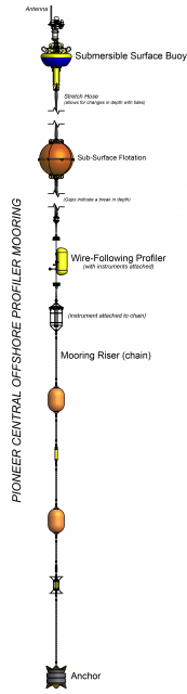
The Pioneer NES Central Offshore Profiler Mooring is located at the Continental Shelf-Slope Break approximately 150 meters deep. The Continental Shelf-Slope area off the New England coast is a highly productive area and one that is located at a dynamic intersection where ocean currents meet in weather-like “fronts,” and where nutrients, pollutants, and other properties are exchanged between the coast and the deep ocean. Data from the slope break area help to examine exchanges between the shelf and slope and the shelf ecosystem, as well as provide broader insight into the issues of air-sea gas exchange, including Carbon Dioxide.
Like other Coastal Profiler Moorings, the Pioneer NES Central Offshore Profiler Mooring contains a Wire-Following Profiler that houses instruments. The Wire-Following Profiler moves through the water column along the mooring riser, continuously sampling ocean characteristics over a specified depth interval.
Read MoreCP02PMCI
The Coastal Pioneer New England Shelf Central Inshore Profiler Mooring is located at the Continental Shelf-Slope Break approximately 130 meters deep. The Continental Shelf-Slope area off the New England coast is a highly productive area and one that is located at a dynamic intersection where ocean currents meet in weather-like “fronts,” and where nutrients, pollutants, and other properties are exchanged between the coast and the deep ocean.
Platform DOI and Citation Guidance
OOI assigns Digital Object Identifiers (DOIs) at the platform or site level. The DOI for the Coastal Pioneer New England Shelf Central Inshore Profiler Mooring is 10.58046/OOI-CP02PMCI.
The minimum recommended citation for this platform is:
NSF Ocean Observatories Initiative. (2014). Coastal Pioneer New England Shelf Central Inshore Profiler Mooring, DOI: 10.58046/OOI-CP02PMCI.
This follows the format NSF Ocean Observatories Initiative. (Year Published). Platform title, DOI: Platform DOI, where Year Published is the year OOI data collection began at the site.
We encourage data users to incorporate full citations when referencing OOI data in order to support FAIR data principles and data traceability. OOI also provides further guidance on citations, including information on adding specific data products and data access points to citations.
Data Access
The following links provide data access via Data Explorer or other methods:
- Direct access to the data on this platform and its subcomponents
- General access to OOI data using a variety of methods
Platform Description
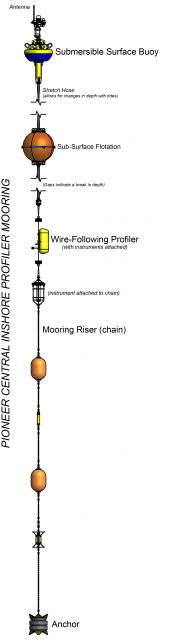
The Pioneer NES Central Inshore Profiler Mooring is located at the Continental Shelf-Slope Break approximately 130 meters deep. The Continental Shelf-Slope area off the New England coast is a highly productive area and one that is located at a dynamic intersection where ocean currents meet in weather-like “fronts,” and where nutrients, pollutants, and other properties are exchanged between the coast and the deep ocean. Data from the slope break area help to examine exchanges between the shelf and slope and the shelf ecosystem, as well as provide broader insight into the issues of air-sea gas exchange, including Carbon Dioxide.
Like other Coastal Profiler Moorings, the Pioneer NES Central Inshore Profiler Mooring contains a Wire-Following Profiler that houses instruments. The Wire-Following Profiler moves through the water column along the mooring riser, continuously sampling ocean characteristics over a specified depth interval.
Read MoreCP01CNSP
The Coastal Pioneer New England Shelf Central Surface Piercing Profiler Mooring is located on the Continental Shelf, approximately 130 meters deep. The Continental Shelf-Slope area off the New England coast is a highly productive area and one that is located at a dynamic intersection where ocean currents meet in weather-like “fronts,” and where nutrients, pollutants, and other properties are exchanged between the coast and the deep ocean.
Platform DOI and Citation Guidance
OOI assigns Digital Object Identifiers (DOIs) at the platform or site level. The DOI for the Coastal Pioneer New England Shelf Central Surface Piercing Profiler Mooring is 10.58046/OOI-CP01CNSP.
The minimum recommended citation for this platform is:
NSF Ocean Observatories Initiative. (2015). Coastal Pioneer New England Shelf Central Surface Piercing Profiler Mooring, DOI: 10.58046/OOI-CP01CNSP.
This follows the format NSF Ocean Observatories Initiative. (Year Published). Platform title, DOI: Platform DOI, where Year Published is the year OOI data collection began at the site.
We encourage data users to incorporate full citations when referencing OOI data in order to support FAIR data principles and data traceability. OOI also provides further guidance on citations, including information on adding specific data products and data access points to citations.
Data Access
The following links provide data access via Data Explorer or other methods:
- Direct access to the data on this platform and its subcomponents
- General access to OOI data using a variety of methods
Platform Description
[box type="note"]In the fall of 2015, deployments of the Coastal Surface Piercing Profiler (CSPP) Moorings at the Pioneer NES Array were suspended. In the spring of 2016 the Program approved the use of Coastal Profiling Gliders in the summer and Profiler Moorings in the winter at the sites previously occupied by CSPPs.[/box]The Pioneer NES Central Surface Piercing Profiler Mooring is located on the Continental Shelf, approximately 130 meters deep. The Continental Shelf-Slope area off the New England coast is a highly productive area and one that is located at a dynamic intersection where ocean currents meet in weather-like “fronts,” and where nutrients, pollutants, and other properties are exchanged between the coast and the deep ocean. Data from the shelf area help to examine exchanges between the shelf and slope and the shelf ecosystem, as well as provide broader insight into the issues of air-sea gas exchange, including Carbon Dioxide.
Like other Surface Piercing Profiler Moorings, this mooring contains a Surface Piercing Profiler that allows for the sampling of near surface phenomena as the Profiler travels through the water then breaches the surface. Fine resolution sampling of the water column, particularly at the very surface of the water, provides key insights into the exchange of gases, heat, etc. between the atmosphere and the ocean. While on the surface, the profiler transmits data to shore.
Read MoreCP01CNSM
The Coastal Pioneer New England Shelf Central Surface Mooring is located on the Continental Shelf, approximately 130 meters deep. The Continental Shelf-Slope area off the New England coast is a highly productive area and one that is located at a dynamic intersection where ocean currents meet in weather-like “fronts,” and where nutrients, pollutants, and other properties are exchanged between the coast and the deep ocean.
Platform DOI and Citation Guidance
OOI assigns Digital Object Identifiers (DOIs) at the platform or site level. The DOI for the Coastal Pioneer New England Shelf Central Surface Mooring is 10.58046/OOI-CP01CNSM.
The minimum recommended citation for this platform is:
NSF Ocean Observatories Initiative. (2013). Coastal Pioneer New England Shelf Central Surface Mooring, DOI: 10.58046/OOI-CP01CNSM.
This follows the format NSF Ocean Observatories Initiative. (Year Published). Platform Title, DOI: Platform DOI, where Year Published is the year OOI data collection began at the site.
We encourage data users to incorporate full citations when referencing OOI data in order to support FAIR data principles and data traceability. OOI also provides further guidance on citations, including information on adding specific data products and data access points to citations.
Data Access
The following links provide data access via Data Explorer or other methods:
- Direct access to the data on this platform and its subcomponents
- General access to OOI data using a variety of methods
Platform Description
The Pioneer NES Central Surface Mooring is located on the Continental Shelf, approximately 130 meters deep. The Continental Shelf-Slope area off the New England coast is a highly productive area and one that is located at a dynamic intersection where ocean currents meet in weather-like “fronts,” and where nutrients, pollutants, and other properties are exchanged between the coast and the deep ocean. Data from the shelf area help to examine exchanges between the shelf and slope and the shelf ecosystem, as well as provide broader insight into the issues of air-sea gas exchange, including Carbon Dioxide.
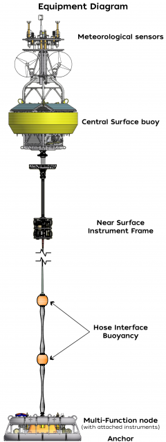
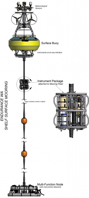
Like other coastal moorings, the Pioneer NES Central Surface Mooring is specifically designed to examine coastal-scale phenomena and withstand the challenging conditions of shallow coastal environments, including large tidal fluctuations. The Surface Mooring contains instruments attached to a Surface Buoy floating on the sea surface, Near Surface Instrument Frame 7 meters below the surface, and a Seafloor Multi-Function Node (MFN) located on the seafloor. The Surface Buoy provides a platform on which to secure surface instruments above the sea surface, below the sea surface, and across the interface between. Additionally the Surface Buoy contains an antenna to transmit data to shore via satellite.
Read MoreCE09OSSM
The Coastal Endurance Washington Offshore Surface Mooring is located on the Continental Slope, approximately 550 meters deep. The Continental Shelf-Slope area off the Washington coast is a highly productive, dynamic upwelling environment.
Platform DOI and Citation Guidance
OOI assigns Digital Object Identifiers (DOIs) at the platform or site level. The DOI for the Coastal Endurance Washington Offshore Surface Mooring is 10.58046/OOI-CE09OSSM.
The minimum recommended citation for this platform is:
NSF Ocean Observatories Initiative. (2015). Coastal Endurance Washington Offshore Surface Mooring, DOI: 10.58046/OOI-CE09OSSM.
This follows the format NSF Ocean Observatories Initiative. (Year Published). Platform title, DOI: Platform DOI, where Year Published is the year OOI data collection began at the site.
We encourage data users to incorporate full citations when referencing OOI data in order to support FAIR data principles and data traceability. OOI also provides further guidance on citations, including information on adding specific data products and data access points to citations.
Data Access
The following links provide data access via Data Explorer or other methods:
- Direct access to the data on this platform and its subcomponents
- General access to OOI data using a variety of methods
Platform Description
The Coastal Endurance Washington Offshore Surface Mooring is located on the Continental Slope, approximately 550 meters deep. The Continental Shelf-Slope area off the Washington coast is a highly productive, dynamic upwelling environment. Upwelling brings nutrients to the surface sparking primary production and fueling the food web. In recent years, upwelling has also brought onto the shelf hypoxic, low oxygen, waters that can be harmful to organisms in the area. By sampling in this area, the OOI seeks to gain better insight into upwelling dynamics of this system.
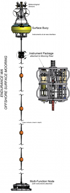
Like other coastal moorings, the Coastal Endurance Washington Offshore Surface Mooring is specifically designed to examine coastal-scale phenomena and withstand the challenging conditions of shallow coastal environments, including large tidal fluctuations. The Surface Mooring contains instruments attached to a Surface Buoy floating on the sea surface, Near Surface Instrument Frame 7 meters below the surface, and a Seafloor Multi-Function Node (MFN) located on the seafloor. The Surface Buoy provides a platform on which to secure surface instruments above the sea surface, below the sea surface, and across the interface between. Additionally the Surface Buoy contains an antenna to transmit data to shore via satellite.
Read MoreCE07SHSP
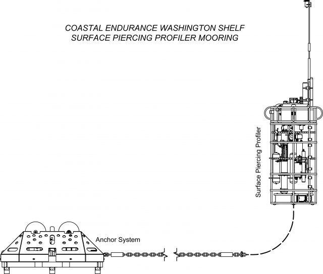
The Coastal Endurance Washington Shelf Surface Piercing Profiler Mooring is located on the Continental Shelf, approximately 87 meters deep. The Continental Shelf-Slope area off the Washington coast is a highly productive, dynamic upwelling environment.
Platform DOI and Citation Guidance
OOI assigns Digital Object Identifiers (DOIs) at the platform or site level. The DOI for the Coastal Endurance Washington Shelf Surface Piercing Profiler Mooring is 10.58046/OOI-CE07SHSP.
The minimum recommended citation for this platform is:
NSF Ocean Observatories Initiative. (2015). Coastal Endurance Washington Shelf Surface Piercing Profiler Mooring, DOI: 10.58046/OOI-CE07SHSP.
This follows the format NSF Ocean Observatories Initiative. (Year Published). Platform title, DOI: Platform DOI, where Year Published is the year OOI data collection began at the site.
We encourage data users to incorporate full citations when referencing OOI data in order to support FAIR data principles and data traceability. OOI also provides further guidance on citations, including information on adding specific data products and data access points to citations.
Data Access
The following links provide data access via Data Explorer or other methods:
- Direct access to the data on this platform and its subcomponents
- General access to OOI data using a variety of methods
Platform Description
The Coastal Endurance Washington Shelf Surface Piercing Profiler Mooring is located on the Continental Shelf, approximately 87 meters deep. The Continental Shelf-Slope area off the Washington coast is a highly productive, dynamic upwelling environment. Upwelling brings nutrients to the surface sparking primary production and fueling the food web. In recent years, upwelling has also brought onto the shelf hypoxic, low oxygen, waters that can be harmful to organisms in the area. By sampling in this area, the OOI seeks to gain better insight into upwelling dynamics of this system.
Like other Surface Piercing Profiler Moorings, this mooring contains a Surface Piercing Profiler that allows for the sampling of near surface phenomena as the Profiler travels through the water then breaches the surface. Fine resolution sampling of the water column, particularly at the very surface of the water, provides key insights into the exchange of gases, heat, etc. between the atmosphere and the ocean. While on the surface, the profiler transmits data to shore.
Read MoreCE07SHSM
The Coastal Endurance Washington Shelf Surface Mooring is located on the Continental Shelf, approximately 90 meters deep. The Continental Shelf-Slope area off the Washington coast is a highly productive, dynamic upwelling environment.
Platform DOI and Citation Guidance
OOI assigns Digital Object Identifiers (DOIs) at the platform or site level. The DOI for the Coastal Endurance Washington Shelf Surface Mooring is 10.58046/OOI-CE07SHSM.
The minimum recommended citation for this platform is:
NSF Ocean Observatories Initiative. (2015). Coastal Endurance Washington Shelf Surface Mooring, DOI: 10.58046/OOI-CE07SHSM.
This follows the format NSF Ocean Observatories Initiative. (Year Published). Platform title, DOI: Platform DOI, where Year Published is the year OOI data collection began at the site.
We encourage data users to incorporate full citations when referencing OOI data in order to support FAIR data principles and data traceability. OOI also provides further guidance on citations, including information on adding specific data products and data access points to citations.
Data Access
The following links provide data access via Data Explorer or other methods:
- Direct access to the data on this platform and its subcomponents
- General access to OOI data using a variety of methods
Platform Description
The Coastal Endurance Washington Shelf Surface Mooring is located on the Continental Shelf, approximately 90 meters deep. The Continental Shelf-Slope area off the Washington coast is a highly productive, dynamic upwelling environment. Upwelling brings nutrients to the surface sparking primary production and fueling the food web. In recent years, upwelling has also brought onto the shelf hypoxic, low oxygen, waters that can be harmful to organisms in the area. By sampling in this area, the OOI seeks to gain better insight into upwelling dynamics of this system.
Like other coastal moorings, the Coastal Endurance Washington Shelf Surface Mooring is specifically designed to examine coastal-scale phenomena and withstand the challenging conditions of shallow coastal environments, including large tidal fluctuations. The Surface Mooring contains instruments attached to a Surface Buoy floating on the sea surface, Near Surface Instrument Frame 7 meters below the surface, and a Seafloor Multi-Function Node (MFN) located on the seafloor. The Surface Buoy provides a platform on which to secure surface instruments above the sea surface, below the sea surface, and across the interface between. Additionally the Surface Buoy contains an antenna to transmit data to shore via satellite.
Read MoreCE06ISSP
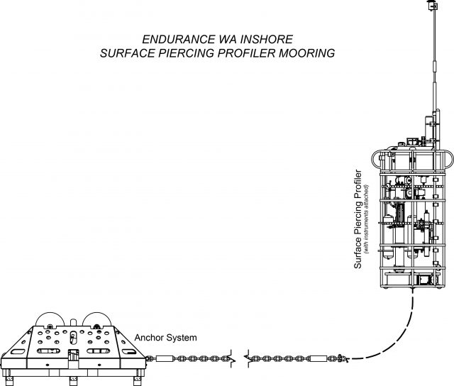
The Coastal Endurance Washington Inshore Surface Piercing Profiler Mooring is located on the inner Continental Shelf, approximately 29 meters deep. The Continental Shelf-Slope area off the Washington coast is a highly productive, dynamic upwelling environment.
Platform DOI and Citation Guidance
OOI assigns Digital Object Identifiers (DOIs) at the platform or site level. The DOI for the Coastal Endurance Washington Inshore Surface Piercing Profiler Mooring is 10.58046/OOI-CE06ISSP.
The minimum recommended citation for this platform is:
NSF Ocean Observatories Initiative. (2015). Coastal Endurance Washington Inshore Surface Piercing Profiler Mooring, DOI: 10.58046/OOI-CE06ISSP.
This follows the format NSF Ocean Observatories Initiative. (Year Published). Platform title, DOI: Platform DOI, where Year Published is the year OOI data collection began at the site.
We encourage data users to incorporate full citations when referencing OOI data in order to support FAIR data principles and data traceability. OOI also provides further guidance on citations, including information on adding specific data products and data access points to citations.
Data Access
The following links provide data access via Data Explorer or other methods:
- Direct access to the data on this platform and its subcomponents
- General access to OOI data using a variety of methods
Platform Description
The Coastal Endurance Washington Inshore Surface Piercing Profiler Mooring is located on the inner Continental Shelf, approximately 29 meters deep. The Continental Shelf-Slope area off the Washington coast is a highly productive, dynamic upwelling environment. Upwelling brings nutrients to the surface sparking primary production and fueling the food web. In recent years, upwelling has also brought onto the shelf hypoxic, low oxygen, waters that can be harmful to organisms in the area. By sampling in this area, the OOI seeks to gain better insight into upwelling dynamics of this system.
Like other Surface Piercing Profiler Moorings, this mooring contains a Surface-Piercing Profiler that allows for the sampling of near surface phenomena as the Profiler travels through the water then breaches the surface. Fine resolution sampling of the water column, particularly at the very surface of the water, provides key insights into the exchange of gases, heat, etc. between the atmosphere and the ocean. While on the surface, the profiler transmits data to shore.
Read More