
CE06ISSM

The Coastal Endurance Washington Inshore Surface Mooring is located on the inner Continental Shelf, approximately 30 meters deep. The Continental Shelf-Slope area off the Washington coast is a highly productive, dynamic upwelling environment.
Platform DOI and Citation Guidance
OOI assigns Digital Object Identifiers (DOIs) at the platform or site level. The DOI for the Coastal Endurance Washington Inshore Surface Mooring is 10.58046/OOI-CE06ISSM.
The minimum recommended citation for this platform is:
NSF Ocean Observatories Initiative. (2014). Coastal Endurance Washington Inshore Surface Mooring, DOI: 10.58046/OOI-CE06ISSM.
This follows the format NSF Ocean Observatories Initiative. (Year Published). Platform title, DOI: Platform DOI, where Year Published is the year OOI data collection began at the site.
We encourage data users to incorporate full citations when referencing OOI data in order to support FAIR data principles and data traceability. OOI also provides further guidance on citations, including information on adding specific data products and data access points to citations.
Data Access
The following links provide data access via Data Explorer or other methods:
- Direct access to the data on this platform and its subcomponents
- General access to OOI data using a variety of methods
Platform Description
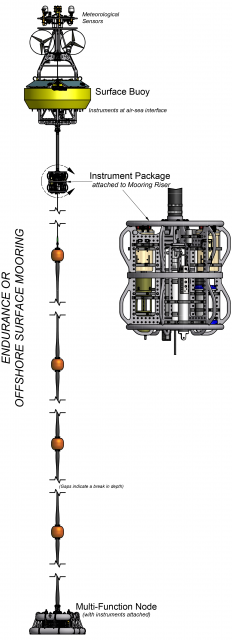
The Coastal Endurance Washington Inshore Surface Mooring is located on the inner Continental Shelf, approximately 30 meters deep. The Continental Shelf-Slope area off the Washington coast is a highly productive, dynamic upwelling environment. Upwelling brings nutrients to the surface sparking primary production and fueling the food web. In recent years, upwelling has also brought onto the shelf hypoxic, low oxygen, waters that can be harmful to organisms in the area. By sampling in this area, the OOI seeks to gain better insight into upwelling dynamics of this system.
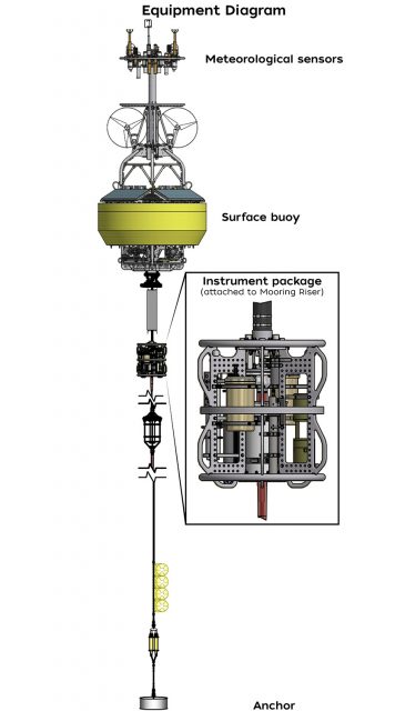
Like other coastal moorings, the Coastal Endurance Washington Inshore Surface Mooring is specifically designed to examine coastal-scale phenomena and withstand the challenging conditions of shallow coastal environments, including large tidal fluctuations. The Surface Mooring contains instruments attached to a Surface Buoy floating on the sea surface, Near Surface Instrument Frame 7 meters below the surface, and a Seafloor Multi-Function Node (MFN) located on the seafloor. The Surface Buoy provides a platform on which to secure surface instruments above the sea surface, below the sea surface, and across the interface between. Additionally the Surface Buoy contains an antenna to transmit data to shore via satellite.
Read MoreCE05MOAS

An array of ~6 gliders travels along five east-west transect lines within the Coastal Endurance Array from approximately the 20-m isobaths to 126 W (and out to 128 W along the Oregon and Washington lines), as well as a north-south transect along 126 W.
Platform DOI and Citation Guidance
OOI assigns Digital Object Identifiers (DOIs) at the platform or site level. The DOI for the Coastal Endurance Array Mobile Assets is 10.58046/OOI-CE05MOAS.
The minimum recommended citation for this platform is:
NSF Ocean Observatories Initiative. (2014). Coastal Endurance Array Mobile Assets, DOI: 10.58046/OOI-CE05MOAS.
This follows the format NSF Ocean Observatories Initiative. (Year Published). Platform title, DOI: Platform DOI, where Year Published is the year OOI data collection began at the site.
We encourage data users to incorporate full citations when referencing OOI data in order to support FAIR data principles and data traceability. OOI also provides further guidance on citations, including information on adding specific data products and data access points to citations.
Data Access
The following links provide data access via Data Explorer or other methods:
- Direct access to the data on this platform and its subcomponents
- General access to OOI data using a variety of methods
Platform Description
An array of ~6 gliders travels along five east-west transect lines within the Coastal Endurance Array from approximately the 20-m isobaths to 126 W (and out to 128 W along the Oregon and Washington lines), as well as a north-south transect along 126 W.
Coastal Gliders (Teledyne-Webb Slocum Gliders) fly through the water column along saw-tooth paths, penetrating the sea surface and diving down to depth. These Coastal Gliders are outfitted with one of two buoyancy engines allowing for maximum efficiency for either shallow (able to dive to 200 m) or deep (able to dive to 1000 m) dives. A roughly even combination of deep and shallow diving coastal gliders have been deployed, sufficient to survey the Endurance Array area.
Gliders are buoyancy-driven mobile assets. They change their buoyancy by drawing in water through their nose making their front end heavy causing them to sink through the water. To float back up to the surface, they push the water out. Their wings provide lift allowing the gliders to move forward as they change depth. Due to their efficient design, with no need for propellers or an engine, gliders can be deployed for several months at a time.
Read MoreCE04OSSM
The Coastal Endurance Oregon Offshore Surface Mooring is located on the Continental Slope, approximately 550 meters deep. The Continental Shelf-Slope area off the Oregon coast is a highly productive, dynamic upwelling environment.
Platform DOI and Citation Guidance
OOI assigns Digital Object Identifiers (DOIs) at the platform or site level. The DOI for the Coastal Endurance Oregon Offshore Surface Mooring is 10.58046/OOI-CE04OSSM.
The minimum recommended citation for this platform is:
NSF Ocean Observatories Initiative. (2015). Coastal Endurance Oregon Offshore Surface Mooring, DOI: 10.58046/OOI-CE04OSSM.
This follows the format NSF Ocean Observatories Initiative. (Year Published). Platform title, DOI: Platform DOI, where Year Published is the year OOI data collection began at the site.
We encourage data users to incorporate full citations when referencing OOI data in order to support FAIR data principles and data traceability. OOI also provides further guidance on citations, including information on adding specific data products and data access points to citations.
Data Access
The following links provide data access via Data Explorer or other methods:
- Direct access to the data on this platform and its subcomponents
- General access to OOI data using a variety of methods
Platform Description
The Coastal Endurance Oregon Offshore Surface Mooring is located on the Continental Slope, approximately 550 meters deep. The Continental Shelf-Slope area off the Oregon coast is a highly productive, dynamic upwelling environment. Upwelling brings nutrients to the surface sparking primary production and fueling the food web. In recent years, upwelling has also brought onto the shelf hypoxic, low oxygen, waters that can be harmful to organisms in the area. By sampling in this area, the OOI seeks to gain better insight into upwelling dynamics of this system.
Like other coastal moorings, the Coastal Endurance Oregon Offshore Surface Mooring is specifically designed to examine coastal-scale phenomena and withstand the challenging conditions of shallow coastal environments, including large tidal fluctuations. The Surface Mooring contains instruments attached to a Surface Buoy floating on the sea surface, Near Surface Instrument Frame 7 meters below the surface, and a Seafloor Multi-Function Node (MFN) located on the seafloor. The Surface Buoy provides a platform on which to secure surface instruments above the sea surface, below the sea surface, and across the interface between. Additionally the Surface Buoy contains an antenna to transmit data to shore via satellite.
Read MoreCE04OSPS
The Coastal Endurance Oregon Offshore Cabled Shallow Profiler Mooring is located on the Continental Slope, approximately 550 meters deep. The Continental Shelf-Slope area off the Oregon coast is a highly productive, dynamic upwelling environment.
Platform DOI and Citation Guidance
OOI assigns Digital Object Identifiers (DOIs) at the platform or site level. The DOI for the Coastal Endurance Oregon Offshore Cabled Shallow Profiler Mooring is 10.58046/OOI-CE04OSPS.
The minimum recommended citation for this platform is:
NSF Ocean Observatories Initiative. (2014). Oregon Offshore Cabled Shallow Profiler Mooring, DOI: 10.58046/OOI-CE04OSPS.
This follows the format NSF Ocean Observatories Initiative. (Year Published). Platform title, DOI: Platform DOI, where Year Published is the year OOI data collection began at the site.
We encourage data users to incorporate full citations when referencing OOI data in order to support FAIR data principles and data traceability. OOI also provides further guidance on citations, including information on adding specific data products and data access points to citations.
Data Access
The following links provide data access via Data Explorer or other methods:
- Direct access to the data on this platform and its subcomponents
- General access to OOI data using a variety of methods
Platform Description
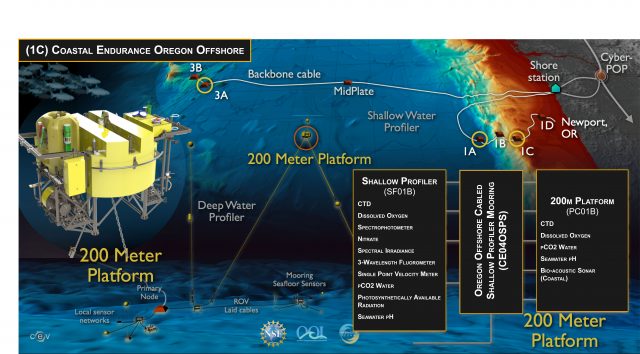
The Oregon Offshore Shallow Profiler Mooring is located on the Continental Slope, approximately 550 meters deep. The Continental Shelf-Slope area off the Oregon coast is a highly productive, dynamic upwelling environment. Upwelling brings nutrients to the surface sparking primary production and fueling the food web. In recent years, upwelling has also brought onto the shelf hypoxic, low oxygen, waters that can be harmful to organisms in the area. By sampling in this area, the OOI seeks to gain better insight into upwelling dynamics of this system.
As with other Cabled Shallow Profiler Moorings, this mooring is attached to a fiber-optic cable and contains a Shallow Profiler (SF01B), a 200m Platform (PC01B), and a Winch Controller (SC01B). The Shallow Profiler houses scientific instrumentation and is tethered to a mooring-mounted winch that pays out line allowing the profiler to rises through the water column until fixed depth (20 m to 200 m below sea surface). Instruments are also housed within the 200m Platform. The fiber-optic cable provides the mooring with a large supply of power and bandwidth and is co-located with a Benthic Experiment Package, that collects complementary seafloor data.
Read MoreGI02HYPM
The Global Irminger Sea Apex Profiler Mooring is co-located with Apex Surface Mooring. Additionally, at the Irminger Sea site are two identical Flanking Subsurface that make up the equidistant sides of a triangle of Moorings (20 km) from the co-located Profiler and Surface Moorings.
Platform DOI and Citation Guidance
OOI assigns Digital Object Identifiers (DOIs) at the platform or site level. The DOI for the Global Irminger Sea Apex Profiler Mooring is 10.58046/OOI-GI02HYPM.
The minimum recommended citation for this platform is:
NSF Ocean Observatories Initiative. (2014). Global Irminger Sea Apex Profiler Mooring, DOI: 10.58046/OOI-GI02HYPM.
This follows the format NSF Ocean Observatories Initiative. (Year Published). Platform title, DOI: Platform DOI, where Year Published is the year OOI data collection began at the site.
We encourage data users to incorporate full citations when referencing OOI data in order to support FAIR data principles and data traceability. OOI also provides further guidance on citations, including information on adding specific data products and data access points to citations.
Data Access
The following links provide data access via Data Explorer or other methods:
- Direct access to the data on this platform and its subcomponents
- General access to OOI data using a variety of methods
Platform Description
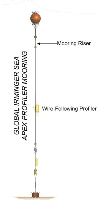
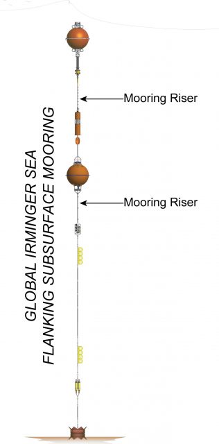
The Global Irminger Sea Apex Profiler Mooring is co-located with Apex Surface Mooring. Additionally, at the Irminger Sea site are two identical Flanking Subsurface that make up the equidistant sides of a triangle of Moorings (20 km) from the co-located Profiler and Surface Moorings. The Profiler Mooring is located in 2,800 meters of water southeast of Greenland in the North Atlantic. The triangular configuration moorings provide unique spatial array through which instruments fixed to moorings continuously collect data through time and gliders sample the area between the moorings. The Irminger Sea site is one of four high latitude open ocean locations in the OOI that provide observations to gain better insight into global ocean circulation and climate.
The Irminger Sea Apex Profiler Mooring contains one Wire-Following Profiler that houses instrumentation. The Wire-Following Profiler moves through the water column along the mooring riser, continuously sampling ocean characteristics at a high vertical resolution over a specified depth interval (240-2,400 meters).
Read MoreGA03FLMA
The Global Argentine Basin array has two identical Flanking Moorings that make up the equidistant sides of a triangle of Moorings (62 km) from the co-located Profiler and Surface Moorings. They are located in 5,200 meters of water along the Brazil Current in the South Atlantic.
Platform DOI and Citation Guidance
OOI assigns Digital Object Identifiers (DOIs) at the platform or site level. The DOI for the Global Argentine Basin Flanking Mooring A is 10.58046/OOI-GA03FLMA.
The minimum recommended citation for this platform is:
NSF Ocean Observatories Initiative. (2015). Global Argentine Basin Flanking Mooring A, DOI: 10.58046/OOI-GA03FLMA.
This follows the format NSF Ocean Observatories Initiative. (Year Published). Platform title, DOI: Platform DOI, where Year Published is the year OOI data collection began at the site.
We encourage data users to incorporate full citations when referencing OOI data in order to support FAIR data principles and data traceability. OOI also provides further guidance on citations, including information on adding specific data products and data access points to citations.
Data Access
The following links provide data access via Data Explorer or other methods:
- Direct access to the data on this platform and its subcomponents
- General access to OOI data using a variety of methods
Platform Description
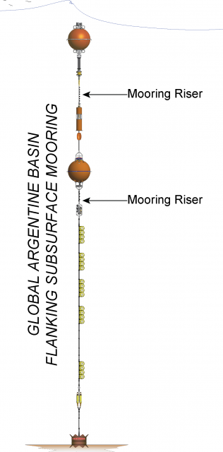
The Global Argentine Basin array has two identical Flanking Moorings that make up the equidistant sides of a triangle of Moorings (62 km) from the co-located Profiler and Surface Moorings. They are located in 5,200 meters of water along the Brazil Current in the South Atlantic. The triangular configuration moorings provide unique spatial array through which instruments fixed to moorings continuously collect data through time and gliders sample the area between the moorings. The Argentine Basin site is one of four high latitude open ocean locations in the OOI that provide observations to gain better insight into global ocean circulation and climate.
Like other Flanking Subsurface Moorings, the Argentine Basing Flanking Subsurface Moorings contain instruments fixed at specific depths along the mooring riser throughout the water column to a depth of 1,500 meters. The flotation buoy for these subsurface moorings is located 30 meters below the sea surface. As they have no surface expression, these moorings communicate and send data to shore via an acoustic link to nearby gliders.
Read MoreGA03FLMB
The Global Argentine Basin array has two identical Flanking Moorings that make up the equidistant sides of a triangle of Moorings (62 km) from the co-located Profiler and Surface Moorings. They are located in 5,200 meters of water along the Brazil Current in the South Atlantic.
Platform DOI and Citation Guidance
OOI assigns Digital Object Identifiers (DOIs) at the platform or site level. The DOI for the Argentine Basin Flanking Mooring B is 10.58046/OOI-GA03FLMB.
The minimum recommended citation for this platform is:
NSF Ocean Observatories Initiative. (2015). Global Argentine Basin Flanking Mooring B, DOI: 10.58046/OOI-GA03FLMB.
This follows the format NSF Ocean Observatories Initiative. (Year Published). Platform title, DOI: Platform DOI, where Year Published is the year OOI data collection began at the site.
We encourage data users to incorporate full citations when referencing OOI data in order to support FAIR data principles and data traceability. OOI also provides further guidance on citations, including information on adding specific data products and data access points to citations.
Data Access
The following links provide data access via Data Explorer or other methods:
- Direct access to the data on this platform and its subcomponents
- General access to OOI data using a variety of methods
Platform Description
The Global Argentine Basin array has two identical Flanking Moorings that make up the equidistant sides of a triangle of Moorings (62 km) from the co-located Profiler and Surface Moorings. They are located in 5,200 meters of water along the Brazil Current in the South Atlantic. The triangular configuration moorings provide unique spatial array through which instruments fixed to moorings continuously collect data through time and gliders sample the area between the moorings. The Argentine Basin site is one of four high latitude open ocean locations in the OOI that provide observations to gain better insight into global ocean circulation and climate.
Like other Flanking Subsurface Moorings, the Argentine Basing Flanking Subsurface Moorings contain instruments fixed at specific depths along the mooring riser throughout the water column to a depth of 1,500 meters. The flotation buoy for these subsurface moorings is located 30 meters below the sea surface. As they have no surface expression, these moorings communicate and send data to shore via an acoustic link to nearby gliders.
Read MoreGA05MOAS
Global Argentine Basin Mobile Assets include two types of gliders that sample the area around the triangular mooring array. An array of 3 Open Ocean Gliders (GLnnn) survey within/between moorings, while two Global Profiling Gliders (PGnnn) survey the upper water column above the Argentine Basin Apex Profiler Mooring.
Platform DOI and Citation Guidance
OOI assigns Digital Object Identifiers (DOIs) at the platform or site level. The DOI for the Global Argentine Basin Mobile Assets is 10.58046/OOI-GA05MOAS.
The minimum recommended citation for this platform is:
NSF Ocean Observatories Initiative. (2015). Global Argentine Basin Mobile Assets, DOI: 10.58046/OOI-GA05MOAS.
This follows the format NSF Ocean Observatories Initiative. (Year Published). Platform title, DOI: Platform DOI, where Year Published is the year OOI data collection began at the site.
We encourage data users to incorporate full citations when referencing OOI data in order to support FAIR data principles and data traceability. OOI also provides further guidance on citations, including information on adding specific data products and data access points to citations.
Data Access
The following links provide data access via Data Explorer or other methods:
- Direct access to the data on this platform and its subcomponents
- General access to OOI data using a variety of methods
Platform Description
Global Argentine Basin Mobile Assets include two types of gliders that sample the area around the triangular mooring array. An array of 3 Open Ocean Gliders (GLnnn) survey within/between moorings, while two Global Profiling Gliders (PGnnn) survey the upper water column above the Argentine Basin Apex Profiler Mooring.
Gliders are buoyancy-driven mobile assets that travel along saw-toothed transects, penetrating the sea surface and diving down to a maximum depth of 1,000 meters. They change their buoyancy by drawing in water through their nose making their front end heavy causing them to sink through the water. To float back up to the surface, they push the water out. Their wings provide lift allowing the gliders to move forward as they change depth. Due to their efficient design, with no need for propellers or an engine, gliders can be deployed for several months at a time.
Read MoreGI01SUMO
The Global Irminger Sea Apex Surface Mooring is co-located with Apex Profiler Mooring. Additionally, at the Irminger Sea site are two identical Flanking Subsurface that make up the equidistant sides of a triangle of Moorings (20 km) from the co-located Profiler and Surface Moorings.
Platform DOI and Citation Guidance
OOI assigns Digital Object Identifiers (DOIs) at the platform or site level. The DOI for the Global Irminger Sea Apex Surface Mooring is 10.58046/OOI-GI01SUMO.
The minimum recommended citation for this platform is:
NSF Ocean Observatories Initiative. (2014). Global Irminger Sea Apex Surface Mooring, DOI: 10.58046/OOI-GI01SUMO.
This follows the format NSF Ocean Observatories Initiative. (Year Published). Platform title, DOI: Platform DOI, where Year Published is the year OOI data collection began at the site.
We encourage data users to incorporate full citations when referencing OOI data in order to support FAIR data principles and data traceability. OOI also provides further guidance on citations, including information on adding specific data products and data access points to citations.
Data Access
The following links provide data access via Data Explorer or other methods:
- Direct access to the data on this platform and its subcomponents
- General access to OOI data using a variety of methods
Platform Description
The Global Irminger Sea Apex Surface Mooring is co-located with Apex Profiler Mooring. Additionally, at the Irminger Sea site are two identical Flanking Subsurface that make up the equidistant sides of a triangle of Moorings (20 km) from the co-located Profiler and Surface Moorings. The Surface Mooring is located in 2,800 meters of water southeast of Greenland in the North Atlantic. The triangular configuration moorings provide unique spatial array through which instruments fixed to moorings continuously collect data through time and gliders sample the area between the moorings. The Irminger Sea site is one of four high latitude open ocean locations in the OOI that provide observations to gain better insight into global ocean circulation and climate. In particular instruments on the Surface Buoy will provide key insights into climate dynamics associated with air-sea fluxes.
Like other Open Ocean Surface Moorings, the Irminger Sea Apex Surface Mooring is specifically designed to examine global phenomena as well as withstand rough sea conditions associated with high latitude, deep, open ocean sites. The Surface Mooring contains instruments attached to a Surface Buoy floating on the sea surface, Near Surface Instrument Frame 12 meters below the surface, and instruments attached to the Mooring Riser at fixed depths through the water column. The Surface Buoy provides a platform on which to secure surface instruments above the sea surface, below the sea surface, and across the interface between. Additionally the Surface Buoy contains an antenna to transmit data to shore via satellite.
Read MoreGI03FLMA
The Global Irminger Sea array has two identical Flanking Moorings that make up the equidistant sides of a triangle of Moorings (20 km) from the co-located Profiler and Surface Moorings. They are located in 2,800 meters of water southeast of Greenland in the North Atlantic.
Platform DOI and Citation Guidance
OOI assigns Digital Object Identifiers (DOIs) at the platform or site level. The DOI for the Global Irminger Sea Flanking Subsurface Mooring A is 10.58046/OOI-GI03FLMA.
The minimum recommended citation for this platform is:
NSF Ocean Observatories Initiative. (2014). Global Irminger Sea Flanking Subsurface Mooring A, DOI: 10.58046/OOI-GI03FLMA.
This follows the format NSF Ocean Observatories Initiative. (Year Published). Platform title, DOI: Platform DOI, where Year Published is the year OOI data collection began at the site.
We encourage data users to incorporate full citations when referencing OOI data in order to support FAIR data principles and data traceability. OOI also provides further guidance on citations, including information on adding specific data products and data access points to citations.
Data Access
The following links provide data access via Data Explorer or other methods:
- Direct access to the data on this platform and its subcomponents
- General access to OOI data using a variety of methods
Platform Description
The Global Irminger Sea array has two identical Flanking Moorings that make up the equidistant sides of a triangle of Moorings (20 km) from the co-located Profiler and Surface Moorings. They are located in 2,800 meters of water southeast of Greenland in the North Atlantic. The triangular configuration moorings provide unique spatial array through which instruments fixed to moorings continuously collect data through time and gliders sample the area between the moorings. The Irminger Sea site is one of four high latitude open ocean locations in the OOI that provide observations to gain better insight into global ocean circulation and climate.
Like other Flanking Subsurface Moorings, the Irminger Sea Flanking Subsurface Moorings contain instruments fixed at specific depths along the mooring riser throughout the water column to a depth of 2,600 meters. The flotation buoy for these subsurface moorings is located 30 meters below the sea surface. As they have no surface expression, these moorings communicate and send data to shore via an acoustic link to nearby gliders.
Read More