
GP03FLMA
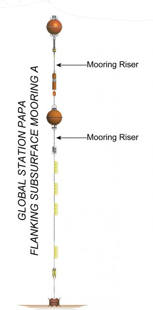
The Station Papa array has two identical Flanking Moorings that make up the equidistant sides of a triangle of Moorings (40 km) from the co-located Profiler and Surface Moorings. They are located in 4,250 meters in the Gulf of Alaska in the NE Pacific.
Platform DOI and Citation Guidance
OOI assigns Digital Object Identifiers (DOIs) at the platform or site level. The DOI for the Global Station Papa Flanking Subsurface Mooring A is 10.58046/OOI-GP03FLMA.
The minimum recommended citation for this platform is:
NSF Ocean Observatories Initiative. (2013). Global Station Papa Flanking Subsurface Mooring A, DOI: 10.58046/OOI-GP03FLMA.
This follows the format NSF Ocean Observatories Initiative. (Year Published). Platform Title, DOI: Platform DOI, where Year Published is the year OOI data collection began at the site.
We encourage data users to incorporate full citations when referencing OOI data in order to support FAIR data principles and data traceability. OOI also provides further guidance on citations, including information on adding specific data products and data access points to citations.
Data Access
The following links provide data access via Data Explorer or other methods:
- Direct access to the data on this platform and its subcomponents
- General access to OOI data using a variety of methods
Platform Description
The Station Papa array has two identical Flanking Moorings that make up the equidistant sides of a triangle of Moorings (40 km) from the co-located Profiler and Surface Moorings. They are located in 4,250 meters in the Gulf of Alaska in the NE Pacific. The triangular configuration moorings provide unique spatial array through which instruments fixed to moorings continuously collect data through time and gliders sample the area between the moorings. The Station Papa site is one of four high latitude open ocean locations in the OOI that provide observations to gain better insight into global ocean circulation and climate.
Like other Flanking Subsurface Moorings, the Station Papa Flanking Subsurface Moorings contain instruments fixed at specific depths along the mooring riser throughout the water column to a depth of 1,500 meters. The flotation buoy for these subsurface moorings is located 30 meters below the sea surface. As they have no surface expression, these moorings communicate and send data to shore via an acoustic link to nearby gliders.
Read MoreGP05MOAS
Global Station Papa Mobile Assets include two types of gliders that sample the area around the triangular mooring array. An array of 3 Open Ocean Gliders (GLnnn) survey within/between moorings, while two Global Profiling Gliders (PGnnn) survey the upper water column above the Station Papa Apex Profiler Mooring.
Platform DOI and Citation Guidance
OOI assigns Digital Object Identifiers (DOIs) at the platform or site level. The DOI for the Global Station Papa Mobile Assets is 10.58046/OOI-GP05MOAS.
The minimum recommended citation for this platform is:
NSF Ocean Observatories Initiative. (2013). Global Station Papa Mobile Assets, DOI: 10.58046/OOI-GP05MOAS.
This follows the format NSF Ocean Observatories Initiative. (Year Published). Platform Title, DOI: Platform DOI, where Year Published is the year OOI data collection began at the site.
We encourage data users to incorporate full citations when referencing OOI data in order to support FAIR data principles and data traceability. OOI also provides further guidance on citations, including information on adding specific data products and data access points to citations.
Data Access
The following links provide data access via Data Explorer or other methods:
- Direct access to the data on this platform and its subcomponents
- General access to OOI data using a variety of methods
Platform Description
Global Station Papa Mobile Assets include two types of gliders that sample the area around the triangular mooring array. An array of 3 Open Ocean Gliders (GLnnn) survey within/between moorings, while two Global Profiling Gliders (PGnnn) survey the upper water column above the Station Papa Apex Profiler Mooring.
Gliders are buoyancy-driven mobile assets that travel along saw-toothed transects, penetrating the sea surface and diving down to a maximum depth of 1,000 meters. They change their buoyancy by drawing in water through their nose making their front end heavy causing them to sink through the water. To float back up to the surface, they push the water out. Their wings provide lift allowing the gliders to move forward as they change depth. Due to their efficient design, with no need for propellers or an engine, gliders can be deployed for several months at a time.
Read MoreGS02HYPM
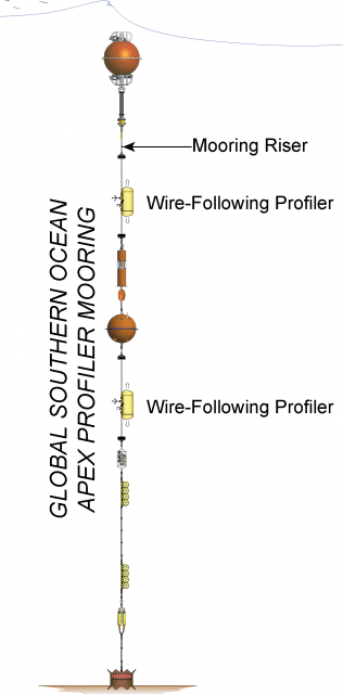
The Global Southern Apex Ocean Profiler Mooring is co-located with Apex Surface Mooring. Additionally, at the Southern Ocean site are two identical Flanking Subsurface that make up the equidistant sides of a triangle of Moorings (50 km) from the co-located Profiler and Surface Moorings.
Platform DOI and Citation Guidance
OOI assigns Digital Object Identifiers (DOIs) at the platform or site level. The DOI for the Global Southern Apex Ocean Profiler Mooring is 10.58046/OOI-GS02HYPM.
The minimum recommended citation for this platform is:
NSF Ocean Observatories Initiative. (2015). Global Southern Apex Ocean Profiler Mooring, DOI: 10.58046/OOI-GS02HYPM.
This follows the format NSF Ocean Observatories Initiative. (Year Published). Platform title, DOI: Platform DOI, where Year Published is the year OOI data collection began at the site.
We encourage data users to incorporate full citations when referencing OOI data in order to support FAIR data principles and data traceability. OOI also provides further guidance on citations, including information on adding specific data products and data access points to citations.
Data Access
The following links provide data access via Data Explorer or other methods:
- Direct access to the data on this platform and its subcomponents
- General access to OOI data using a variety of methods
Platform Description
The Southern Ocean Apex Profiler Mooring is co-located with Apex Surface Mooring. Additionally, at the Southern Ocean site are two identical Flanking Subsurface that make up the equidistant sides of a triangle of Moorings (50 km) from the co-located Profiler and Surface Moorings. The Profiler Mooring is located in 4,800 meters of water in the Southern Ocean, SW of Chile. The triangular configuration moorings provide unique spatial array through which instruments fixed to moorings continuously collect data through time and gliders sample the area between the moorings. The Southern Ocean site is one of four high latitude open ocean locations in the OOI that provide observations to gain better insight into global ocean circulation and climate.
Like other Apex Profiler Moorings, the Southern Ocean Apex Profiler Mooring contains two Wire-Following Profilers that house instrumentation. The Wire-Following Profiler moves through the water column along the mooring riser, continuously sampling ocean characteristics at a high vertical resolution over a specified depth interval (310-2,100 meters and 2,100-4,400 meters deep).
Read MoreGS03FLMA
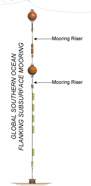
The Southern Ocean array has two identical Flanking Moorings that make up the equidistant sides of a triangle of Moorings (50 km) from the co-located Profiler and Surface Moorings. They are located in 4,800 meters of water in the Southern Ocean, SW of Chile.
Platform DOI and Citation Guidance
OOI assigns Digital Object Identifiers (DOIs) at the platform or site level. The DOI for the Global Southern Ocean Flanking Subsurface Mooring A is 10.58046/OOI-GS03FLMA.
The minimum recommended citation for this platform is:
NSF Ocean Observatories Initiative. (2015). Global Southern Ocean Flanking Subsurface Mooring A, DOI: 10.58046/OOI-GS03FLMA.
This follows the format NSF Ocean Observatories Initiative. (Year Published). Platform title, DOI: Platform DOI, where Year Published is the year OOI data collection began at the site.
We encourage data users to incorporate full citations when referencing OOI data in order to support FAIR data principles and data traceability. OOI also provides further guidance on citations, including information on adding specific data products and data access points to citations.
Data Access
The following links provide data access via Data Explorer or other methods:
- Direct access to the data on this platform and its subcomponents
- General access to OOI data using a variety of methods
Platform Description
The Southern Ocean array has two identical Flanking Moorings that make up the equidistant sides of a triangle of Moorings (50 km) from the co-located Profiler and Surface Moorings. They are located in 4,800 meters of water in the Southern Ocean, SW of Chile. The triangular configuration moorings provide unique spatial array through which instruments fixed to moorings continuously collect data through time and gliders sample the area between the moorings. The Southern Ocean site is one of four high latitude open ocean locations in the OOI that provide observations to gain better insight into global ocean circulation and climate.
Like other Flanking Subsurface Moorings, the Southern Ocean Flanking Subsurface Moorings contain instruments fixed at specific depths along the mooring riser throughout the water column to a depth of 1,500 meters. The flotation buoy for these subsurface moorings is located 30 meters below the sea surface. As they have no surface expression, these moorings communicate and send data to shore via an acoustic link to nearby gliders.
Read MoreGS01SUMO
The Global Southern Apex Ocean Surface Mooring is co-located with Apex Profiler Mooring. Additionally, at the Southern Ocean site are two identical Flanking Subsurface that make up the equidistant sides of a triangle of Moorings (50 km) from the co-located Profiler and Surface Moorings.
Platform DOI and Citation Guidance
OOI assigns Digital Object Identifiers (DOIs) at the platform or site level. The DOI for the Global Southern Apex Ocean Surface Mooring is 10.58046/OOI-GS01SUMO.
The minimum recommended citation for this platform is:
NSF Ocean Observatories Initiative. (2015). Global Southern Apex Ocean Surface Mooring, DOI: 10.58046/OOI-GS01SUMO.
This follows the format NSF Ocean Observatories Initiative. (Year Published). Platform title, DOI: Platform DOI, where Year Published is the year OOI data collection began at the site.
We encourage data users to incorporate full citations when referencing OOI data in order to support FAIR data principles and data traceability. OOI also provides further guidance on citations, including information on adding specific data products and data access points to citations.
Data Access
The following links provide data access via Data Explorer or other methods:
- Direct access to the data on this platform and its subcomponents
- General access to OOI data using a variety of methods
Platform Description
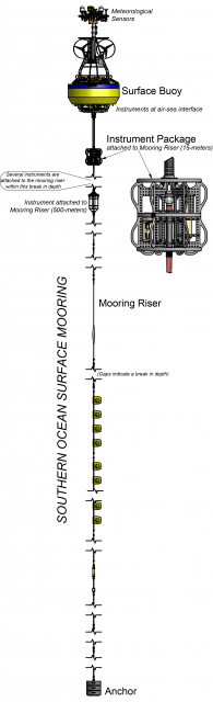
The Southern Ocean Apex Surface Mooring is co-located with Apex Profiler Mooring. Additionally, at the Southern Ocean site are two identical Flanking Subsurface that make up the equidistant sides of a triangle of Moorings (50 km) from the co-located Profiler and Surface Moorings. The Surface Mooring is located in 4,800 meters of water in the Southern Ocean, SW of Chile. The triangular configuration moorings provide unique spatial array through which instruments fixed to moorings continuously collect data through time and gliders sample the area between the moorings. The Southern Ocean site is one of four high latitude open ocean locations in the OOI that provide observations to gain better insight into global ocean circulation and climate. In particular instruments on the Surface Buoy will provide key insights into climate dynamics associated with air-sea fluxes.
Like other Open Ocean Surface Moorings, the Southern Ocean Apex Surface Mooring is specifically designed to examine global phenomena as well as withstand rough sea conditions associated with high latitude, deep, open ocean sites. The Surface Mooring contains instruments attached to a Surface Buoy floating on the sea surface, Near Surface Instrument Frame 12 meters below the surface, and instruments attached to the Mooring Riser at fixed depths through the water column. The Surface Buoy provides a platform on which to secure surface instruments above the sea surface, below the sea surface, and across the interface between. Additionally the Surface Buoy contains an antenna to transmit data to shore via satellite.
Read MoreGS03FLMB
The Southern Ocean array has two identical Flanking Moorings that make up the equidistant sides of a triangle of Moorings (50 km) from the co-located Profiler and Surface Moorings. They are located in 4,800 meters of water in the Southern Ocean, SW of Chile.
Platform DOI and Citation Guidance
OOI assigns Digital Object Identifiers (DOIs) at the platform or site level. The DOI for the Global Southern Ocean Flanking Subsurface Mooring B is 10.58046/OOI-GS03FLMB.
The minimum recommended citation for this platform is:
NSF Ocean Observatories Initiative. (2015). Global Southern Ocean Flanking Subsurface Mooring B, DOI: 10.58046/OOI-GS03FLMB.
This follows the format NSF Ocean Observatories Initiative. (Year Published). Platform title, DOI: Platform DOI, where Year Published is the year OOI data collection began at the site.
We encourage data users to incorporate full citations when referencing OOI data in order to support FAIR data principles and data traceability. OOI also provides further guidance on citations, including information on adding specific data products and data access points to citations.
Data Access
The following links provide data access via Data Explorer or other methods:
- Direct access to the data on this platform and its subcomponents
- General access to OOI data using a variety of methods
Platform Description
The Southern Ocean array has two identical Flanking Moorings that make up the equidistant sides of a triangle of Moorings (50 km) from the co-located Profiler and Surface Moorings. They are located in 4,800 meters of water in the Southern Ocean, SW of Chile. The triangular configuration moorings provide unique spatial array through which instruments fixed to moorings continuously collect data through time and gliders sample the area between the moorings. The Southern Ocean site is one of four high latitude open ocean locations in the OOI that provide observations to gain better insight into global ocean circulation and climate.
Like other Flanking Subsurface Moorings, the Southern Ocean Flanking Subsurface Moorings contain instruments fixed at specific depths along the mooring riser throughout the water column to a depth of 1,500 meters. The flotation buoy for these subsurface moorings is located 30 meters below the sea surface. As they have no surface expression, these moorings communicate and send data to shore via an acoustic link to nearby gliders.
Read MoreGS05MOAS
Global Southern Ocean Mobile Assets include two types of gliders that sample the area around the triangular mooring array. An array of 3 Open Ocean Gliders (GLnnn) survey within/between moorings, while two Global Profiling Gliders (PGnnn) survey the upper water column above the Southern Ocean Apex Profiler Mooring.
Platform DOI and Citation Guidance
OOI assigns Digital Object Identifiers (DOIs) at the platform or site level. The DOI for the Global Southern Ocean Mobile Assets is 10.58046/OOI-GS05MOAS.
The minimum recommended citation for this platform is:
NSF Ocean Observatories Initiative. (2015). Global Southern Ocean Mobile Assets, DOI: 10.58046/OOI-GS05MOAS.
This follows the format NSF Ocean Observatories Initiative. (Year Published). Platform title, DOI: Platform DOI, where Year Published is the year OOI data collection began at the site.
We encourage data users to incorporate full citations when referencing OOI data in order to support FAIR data principles and data traceability. OOI also provides further guidance on citations, including information on adding specific data products and data access points to citations.
Data Access
The following links provide data access via Data Explorer or other methods:
- Direct access to the data on this platform and its subcomponents
- General access to OOI data using a variety of methods
Platform Description
Global Southern Ocean Mobile Assets include two types of gliders that sample the area around the triangular mooring array. An array of 3 Open Ocean Gliders (GLnnn) survey within/between moorings, while two Global Profiling Gliders (PGnnn) survey the upper water column above the Southern Ocean Apex Profiler Mooring.
Gliders are buoyancy-driven mobile assets that travel along saw-toothed transects, penetrating the sea surface and diving down to a maximum depth of 1,000 meters. They change their buoyancy by drawing in water through their nose making their front end heavy causing them to sink through the water. To float back up to the surface, they push the water out. Their wings provide lift allowing the gliders to move forward as they change depth. Due to their efficient design, with no need for propellers or an engine, gliders can be deployed for several months at a time.
Read MoreRS01SBPD
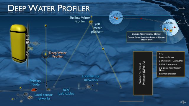
The Oregon Slope Base Deep Profiler Mooring is located adjacent to the continental slope off the coast of Oregon at a water depth of ~2,900 meters. Here, ocean water properties are profoundly impacted by the California Current, and perhaps internal waves.
Platform DOI and Citation Guidance
OOI assigns Digital Object Identifiers (DOIs) at the platform level. The DOI for the Oregon Slope Base Deep Profiler Mooring is 10.58046/OOI-RS01SBPD.
The minimum recommended citation for this platform is:
NSF Ocean Observatories Initiative. (2014). Oregon Slope Base Deep Profiler Mooring, DOI: 10.58046/OOI-RS01SBPD.
This follows the format NSF Ocean Observatories Initiative. (Year Published). Platform title, DOI: Platform DOI, where Year Published is the year OOI data collection began at the platform.
We encourage data users to incorporate full citations when referencing OOI data in order to support FAIR data principles and data traceability. OOI also provides further guidance on citations, including information on adding specific data products and data access points to citations.
Data Access
The following links provide data access via Data Explorer or other methods:
- Direct access to the data on this platform and its subcomponents
- General access to OOI data using a variety of methods
Platform Description
The Oregon Slope Base Deep Profiler Mooring is located adjacent to the continental slope off the coast of Oregon at a water depth of ~2,900 meters. Here, ocean water properties are profoundly impacted by the California Current, and perhaps internal waves. The coastal region of the Pacific Northwest is a classic wind-driven upwelling system where nutrient-rich deep waters rise to replace warmer surface waters. The result is a large increase in marine productivity that ranges from phytoplankton to fish to marine mammals. Near bottom fauna are periodically negatively impacted by the flow of deep waters with very low oxygen concentrations (hypoxia events), and upwelling of corrosive, acidified waters onto the continental shelf.
As with other Cabled Deep Profiler Moorings, this mooring contains a Wire-Following Profiler that transmits data both through WiFi, as well as through an inductive link at its basal docking station that is connected to the cable. The Wire-Following Profiler hosts six instruments and moves through the water column along the mooring cable, continuously sampling ocean characteristics over a specified depth interval (150 meters below sea surface to near bottom). The fiber-optic cable provides the mooring with significant power and bandwidth and is co-located with a Low-Power Jbox, that collects complementary water property data.
When coupled with other Cabled Array and Endurance Array installations off the central Oregon coast, the Slope Base Deep Profiler Mooring will provide a wide variety of opportunities for observing coastal phenomena, including cross-shelf and along-shelf variability.
Read MoreRS01SBPS
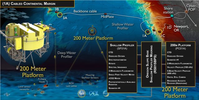
The Oregon Slope Base Shallow Profiler Mooring is situated adjacent to the continental slope off the coast of Oregon approximately 2,900 meters deep. Here, ocean water properties are profoundly impacted by the California Current, and perhaps internal waves.
Platform DOI and Citation Guidance
OOI assigns Digital Object Identifiers (DOIs) at the platform level. The DOI for the Oregon Slope Base Shallow Profiler Mooring is 10.58046/OOI-RS01SBPS.
The minimum recommended citation for this platform is:
NSF Ocean Observatories Initiative. (2014). Oregon Slope Base Shallow Profiler Mooring, DOI: 10.58046/OOI-RS01SBPS.
This follows the format NSF Ocean Observatories Initiative. (Year Published). Platform title, DOI: Platform DOI, where Year Published is the year OOI data collection began at the platform.
We encourage data users to incorporate full citations when referencing OOI data in order to support FAIR data principles and data traceability. OOI also provides further guidance on citations, including information on adding specific data products and data access points to citations.
Data Access
The following links provide data access via Data Explorer or other methods:
- Direct access to the data on this platform and its subcomponents
- General access to OOI data using a variety of methods
Platform Description
The Oregon Slope Base Shallow Profiler Mooring is situated adjacent to the continental slope off the coast of Oregon approximately 2,900 meters deep. Here, ocean water properties are profoundly impacted by the California Current, and perhaps internal waves. The coastal region of the Pacific Northwest is a classic wind-driven upwelling system where nutrient-rich deep waters rise to replace warmer surface waters. The result is a large increase in marine productivity that ranges from phytoplankton to fish to marine mammals. Near bottom fauna are periodically negatively impacted by the flow of deep waters with very low oxygen concentrations (hypoxia events), and upwelling of corrosive, acidified waters onto the continental shelf.
As with other Cabled Shallow Profiler Moorings, this mooring contains a Shallow Profiler (SF01A) and Platform Interface Controller (PC01A), and hosted on a 12 ft across, 7 ton platform that is connected to the fiber-optic cable. The Shallow Profiler houses 10 scientific instruments and is tethered to a winch that pays out fiber optic cable allowing the profiler to rise through the water column until a fixed depth below the oceans surface. The specific depth is determined by currents and wave conditions at the surface. Eight instruments are also housed within the Platform Interface Controller mounted 200 m below the sea surface on the mooring platform. The fiber-optic cable provides the mooring with up to 3000 watts power and 10 Gb communication bandwidth and is co-located with a Low-Power Jbox that collects complementary water column data near the seafloor.
When coupled with other Cabled Array and Endurance Array installations off the central Oregon coast, the Slope Base Shallow Profiler Mooring will provide a wide variety of opportunities for observing coastal phenomena, including cross-shelf and along-shelf variability.
Read MoreGI05MOAS
Global Irminger Sea Mobile Assets include two types of gliders that sample the area around the triangular mooring array. An array of 3 Open Ocean Gliders (GLnnn) survey within/between moorings, while two Global Profiling Gliders (PGnnn) survey the upper water column above the Irminger Sea Apex Profiler Mooring.
Platform DOI and Citation Guidance
OOI assigns Digital Object Identifiers (DOIs) at the platform or site level. The DOI for the Global Irminger Sea Mobile Assets is 10.58046/OOI-GI05MOAS.
The minimum recommended citation for this platform is:
NSF Ocean Observatories Initiative. (2014). Global Irminger Sea Mobile Assets, DOI: 10.58046/OOI-GI05MOAS.
This follows the format NSF Ocean Observatories Initiative. (Year Published). Platform title, DOI: Platform DOI, where Year Published is the year OOI data collection began at the site.
We encourage data users to incorporate full citations when referencing OOI data in order to support FAIR data principles and data traceability. OOI also provides further guidance on citations, including information on adding specific data products and data access points to citations.
Data Access
The following links provide data access via Data Explorer or other methods:
- Direct access to the data on this platform and its subcomponents
- General access to OOI data using a variety of methods
Platform Description
Global Irminger Sea Mobile Assets include two types of gliders that sample the area around the triangular mooring array. An array of 3 Open Ocean Gliders (GLnnn) survey within/between moorings, while two Global Profiling Gliders (PGnnn) survey the upper water column above the Irminger Sea Apex Profiler Mooring.
Gliders are buoyancy-driven mobile assets that travel along saw-toothed transects, penetrating the sea surface and diving down to a maximum depth of 1,000 meters. They change their buoyancy by drawing in water through their nose making their front end heavy causing them to sink through the water. To float back up to the surface, they push the water out. Their wings provide lift allowing the gliders to move forward as they change depth. Due to their efficient design, with no need for propellers or an engine, gliders can be deployed for several months at a time.
Read More