
RS03INT1
The International District Vent Field 1 Medium-Power Jbox supports instruments to investigate the chemistry and temperatures of high temperature and diffuse flow vent sites within the International District Hydrothermal Field located along the eastern rift zone of Axial Seamount at a water depth of ~1520 m.
Site DOI and Citation Guidance
OOI assigns Digital Object Identifiers (DOIs) at the platform or site level. The DOI for the Axial Seamount International District Vent Field 1 is 10.58046/OOI-RS03INT1.
The minimum recommended citation for this site is:
NSF Ocean Observatories Initiative. (2014). Axial Seamount International District Vent Field 1, DOI: 10.58046/OOI-RS03INT1.
This follows the format NSF Ocean Observatories Initiative. (Year Published). Site title, DOI: Site DOI, where Year Published is the year OOI data collection began at the site.
We encourage data users to incorporate full citations when referencing OOI data in order to support FAIR data principles and data traceability. OOI also provides further guidance on citations, including information on adding specific data products and data access points to citations.
Data Access
The following links provide data access via Data Explorer or other methods:
- Direct access to the data on this site and its subcomponents
- General access to OOI data using a variety of methods
Site Description
The International District Vent Field 1 Medium-Power Jbox supports instruments to investigate the chemistry and temperatures of high temperature and diffuse flow vent sites within the International District Hydrothermal Field located along the eastern rift zone of Axial Seamount at a water depth of ~1520 m. The main study sites include the actively venting chimneys called El Gordo, Escargot, and Diva. The El Gordo site also hosts a digital still camera and microbial DNA sampler. Coupled with the geophysical array on the summit of Axial Seamount, these instruments are designed to better understand linkages between seismicity, fluid temperatures and chemistry, and the evolution of biological communities over time in highly dynamic environment commonly perturbed by volcanic eruptions.
Instruments are attached to a Medium-Power J-Box and are mounted on/near the seafloor and on a cabled mooring (e.g fluid and DNA sampler). Axial Seamount on the Juan de Fuca spreading center is an optimal site for a long-term observatory. Not only is it just one day by ship from the Washington and Oregon coasts, but it is the most magmatically robust volcano on the spreading center. Additionally, its caldera hosts numerous active hydrothermal fields and abundant sites of diffuse flow. The International District 1 site monitors one of these hydrothermal vent fields.
Seafloor instruments at the ASHES site are attached to a Medium-Power J-Box (MJ03C) through a series of extension cables. An ~ 2.2 km long extension cable from Primary Node PN3B provides the JBox with significant power (375 v) and bandwidth (1 Gbs) to operate the instruments and transmit data to shore.
Read MoreRS03INT2
The International District Vent Field 2 Medium-Power Jbox, supports geophysical instruments near the International District Hydrothermal Field located on the eastern rift zone within the caldera of Axial Seamount.
Platform DOI and Citation Guidance
OOI assigns Digital Object Identifiers (DOIs) at the platform level. The DOI for the Axial Seamount International District Vent Field 2 is 10.58046/OOI-RS03INT2.
The minimum recommended citation for this platform is:
NSF Ocean Observatories Initiative. (2014). Axial Seamount International District Vent Field 2, DOI: 10.58046/OOI-RS03INT2.
This follows the format NSF Ocean Observatories Initiative. (Year Published). Platform title, DOI: Platform DOI, where Year Published is the year OOI data collection began at the platform.
We encourage data users to incorporate full citations when referencing OOI data in order to support FAIR data principles and data traceability. OOI also provides further guidance on citations, including information on adding specific data products and data access points to citations.
Data Access
The following links provide data access via Data Explorer or other methods:
- Direct access to the data on this platform and its subcomponents
- General access to OOI data using a variety of methods
Platform Description
The International District Vent Field 2 Medium-Power Jbox, supports geophysical instruments near the International District Hydrothermal Field located on the eastern rift zone within the caldera of Axial Seamount. Instruments are attached to a Medium-Power J-Box and are mounted on/near the seafloor.
Instruments are designed to measure local seismic events associated with migration of melt and volatiles within the volcano, microseismic events associated with upwelling of boiling fluids beneath they hydrothermal field, as well as far-field seismic events. Instruments also measure uplift and deflation of the seafloor associated with ingress of melt within the underlying magma chamber, and collapse of the seafloor during diking-eruptive events. This site was chosen because Axial has erupted in 1988, 2011, and again in 2015. During the 2015 event, over 8,000 earthquakes were measured with the cabled geophysical array, and data were streamed live back to shore in real-time. Instruments within the nearby International District 2 site, monitors hydrothermal and biological activity within the vent field.
Seafloor instruments at the ASHES site are attached to a Medium-Power J-Box (MJ03C) through a series of extension cables. An ~ 2.2 km long extension cable from Primary Node PN3B provides the JBox with significant power (375 v) and bandwidth (1 Gbs) to operate the instruments and transmit data to shore.
Read MoreGP02HYPM
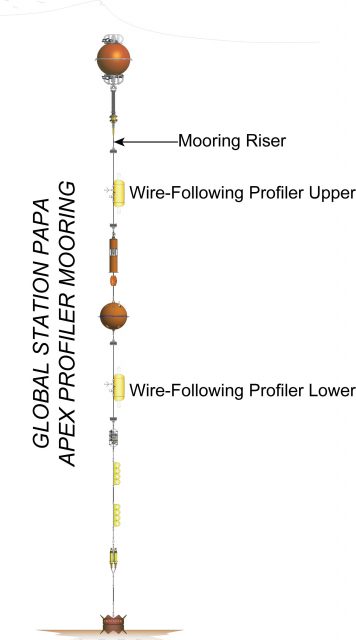
The Global Station Papa Apex Profiler Mooring is co-located with a NOAA Surface Mooring. Additionally, at the Station Papa site are two identical Flanking Subsurface that make up the equidistant sides of a triangle of Moorings (40 km) from the co-located Profiler and Surface Moorings.
Platform DOI and Citation Guidance
OOI assigns Digital Object Identifiers (DOIs) at the platform or site level. The DOI for the Global Station Papa Apex Profiler Mooring is 10.58046/OOI-GP02HYPM.
The minimum recommended citation for this platform is:
NSF Ocean Observatories Initiative. (2013). Global Station Papa Apex Profiler Mooring, DOI: 10.58046/OOI-GP02HYPM.
This follows the format NSF Ocean Observatories Initiative. (Year Published). Platform Title, DOI: Platform DOI, where Year Published is the year OOI data collection began at the site.
We encourage data users to incorporate full citations when referencing OOI data in order to support FAIR data principles and data traceability. OOI also provides further guidance on citations, including information on adding specific data products and data access points to citations.
Data Access
The following links provide data access via Data Explorer or other methods:
- Direct access to the data on this platform and its subcomponents
- General access to OOI data using a variety of methods
Platform Description
The Station Papa Apex Profiler Mooring is co-located with a NOAA Surface Mooring. Additionally, at the Station Papa site are two identical Flanking Subsurface that make up the equidistant sides of a triangle of Moorings (40 km) from the co-located Profiler and Surface Moorings. The Profiler Mooring is located in 4,250 meters in the Gulf of Alaska in the NE Pacific. The triangular configuration moorings provide unique spatial array through which instruments fixed to moorings continuously collect data through time and gliders sample the area between the moorings. The Station Papa site is one of four high latitude open ocean locations in the OOI that provide observations to gain better insight into global ocean circulation and climate.
Like other Apex Profiler Moorings, the Station Papa Apex Profiler Mooring contains two Wire-Following Profilers that house instrumentation. The Wire-Following Profiler moves through the water column along the mooring riser, continuously sampling ocean characteristics at a high vertical resolution over a specified depth interval (156-2090 meters and 2129-4063 meters deep).
Read More