Posts Tagged ‘Global Station Papa Array’
Two OOI Expeditions in Two Oceans
11th Recovery and Deployment of Global Station Papa and Irminger Sea Arrays
Two OOI Global Scale and Nodes (CGSN) teams are working simultaneously, but in different waters on opposite sides of the United States during June. The first CGSN team left Seward, Alaska aboard the R/V Sikuliaq on May 29 for a 17-day expedition to recover and re-deploy the Global Station Papa Array in the Gulf of Alaska. On June 2, a second CGSN team will depart from Woods Hole, MA to travel to the Irminger Sea Array aboard the R/V Neil Armstrong for a month-long expedition to recover and re-deploy this array.
The expeditions share similarities and differences. Both arrays are in remote locations. The Station Papa team has a 2.5-day transit to the array site in the Gulf of Alaska, while the Irminger Sea team has a longer transit of eight days to the array site. Once onsite, the teams will get to work quickly to deploy the replacement moorings to allow for overlapping measurements before recovering the moorings currently in place. This is the 11th time that each array has been turned – that is, existing ocean observing equipment at the sites will be recovered and replacement equipment will be deployed in their place. Such “turns” are needed to address biofouling of sensors, depletion of batteries, and wear and tear on equipment that has been battered by wind, waves, and weather for a year.
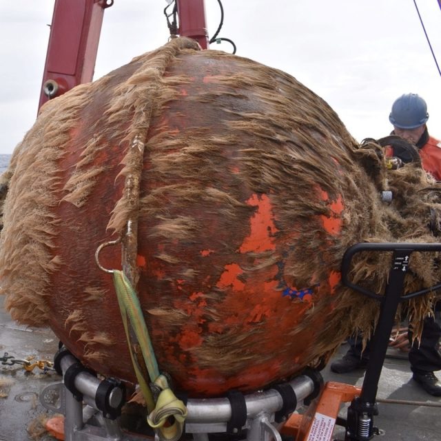
[media-caption path="https://oceanobservatories.org/wp-content/uploads/2024/05/Biofouling.jpg" link="#"]This is what one year in the ocean looks like: a Global Station Papa flanking mooring 64” sphere with 12 months of marine growth. Marine growth can inhibit the operation of the mooring and instruments and is one of the reasons we need to recover and refurbish the OOI infrastructure on a regular basis. Credit: Rebecca Travis © WHOI.[/media-caption]The Global Station Papa Array is located in the Gulf of Alaska, about 620 nautical miles offshore in a critical region of the northeast Pacific with a productive fishery subject to ocean acidification, low eddy variability, and impacted by the Pacific Decadal Oscillation. The Global Irminger Sea Array in the North Atlantic is located in a region with high wind and large surface waves, strong atmosphere-ocean exchanges of energy and gases, carbon dioxide sequestration, high biological productivity, and an important fishery. It is one of the few places on Earth with deep-water formation that feeds the large-scale thermohaline circulation.
“Because of their remote locations, both Station Papa and the Irminger arrays provide critical ocean data that scientists are using to better understand ocean circulation patterns and help identify changes in ocean conditions,” said Sheri N. White, Chief Scientist for the Irminger 11 expedition. “These arrays are hard to get to and to maintain but the data they provide are invaluable.”
Expedition Activities
A team of 11 scientists and engineers aboard the R/V Sikuliaq departed from Seward on May 29 for a 17-day expedition. During their time at sea, they will recover and deploy three OOI subsurface moorings and two open ocean gliders. They also will recover and deploy a Waverider mooring for the University of Washington. A POGO Fellowship awardee will be onboard to gain shipboard experience as part of OOI’s collaborative efforts to provide early career scientists opportunities to help increase their knowledge and advance careers. Other onboard activities will include water sampling at the deployment sites and collection of shipboard underway data.
[media-caption path="https://oceanobservatories.org/wp-content/uploads/2024/05/Irminger-gliders.jpeg" link="#"]The OOI CGSN science team will start operations at the Irminger Array by deploying two gliders. This allows the gliders to be monitored by the pilots onshore and ensure all systems are operational while the vessel is still onsite performing mooring operations. These gliders will operate autonomously at Irminger for ~12 months. Credit: John Lund © WHOI.[/media-caption]On the east coast, a second team of 15 scientists and engineers aboard the R/V Neil Armstrong will leave Woods Hole, Massachusetts on June 2 to begin their eight-day transit to the Irminger Sea. Once onsite, the team will recover and deploy four OOI moorings, deploy two gliders, recover a third, and conduct water sampling at the deployment sites. Underway shipboard data will also be collected throughout the voyage. Four additional subsurface moorings will be “turned” for the Overturning in the Subpolar North Atlantic Project (OSNAP). Water and biogeochemical sampling will be conducted in support of both OSNAP and researchers from Boston College. A marine mammal observer from NOAA will be onboard as a continuing collaboration between NOAA and OOI.
Added White, “When planning these expeditions, we do our best to maximize use of ship time by providing berths to researchers who could benefit from direct observation and data collection in these remote locations. During the expedition to Irminger, for example, we will be joined by a graduate student and two undergraduate students from Boston College who will collect biogeochemical data, and experience what it is like to do science at sea.”
A bird’s eye view of a previous Irminger Sea Array expedition:
[embed]https://www.youtube.com/watch?v=LF6Zhmlmd0A[/embed]Daily reports will be filed from both expeditions. Bookmark this site to follow along.
Read More
Tenth Turn of Global Station Papa Array
The Global Station Papa Array is in the Gulf of Alaska at a critical region of the northeast Pacific Ocean. The region is extremely vulnerable to ocean acidification, has a productive fishery, low eddy variability, and is impacted by the Pacific Decadal Oscillation, often described as the as a long-lived El Niño-like pattern of Pacific climate variability.
A team of 10 scientists and engineers from Woods Hole Oceanographic Institution (WHOI) and the University of Washington will be onboard the R/V Sikuliaq for 15 days in May to ensure that this Array continues to provide data from this important region. The team will deploy three OOI moorings, two open ocean gliders, and one profiling glider. A waverider mooring, which measures wave height and direction, will be deployed for the University of Washington. During the expedition, the team also will be conducting water sampling during recovery and deployments, and sampling while underway for instrument calibration purposes.
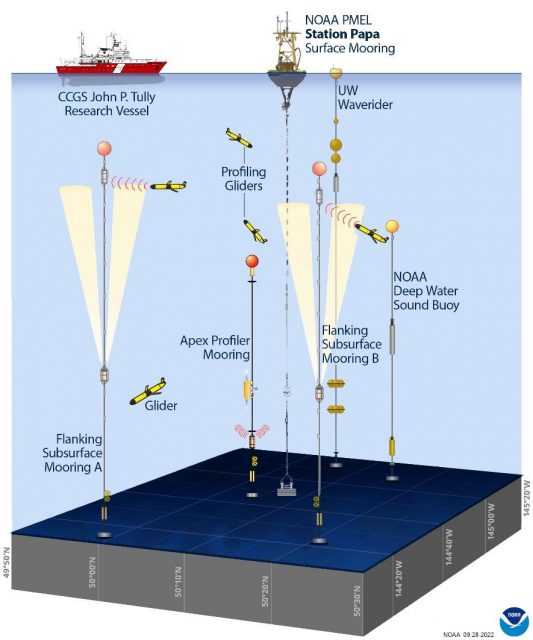
Located next to the NOAA Pacific Marine Environmental Laboratory (PMEL) Surface Buoy and deep-water sound buoy, the Station Papa Array is an important contributor to a cooperatively studied region. The University of Washington operates a waverider mooring near the buoys. The US Coast Guard’s Research Vessel John P. Tully regularly collects data in the region. And the Department of Fisheries in Canada operates a glider line in the region.
[media-caption path="https://oceanobservatories.org/wp-content/uploads/2023/05/CGSN_Papa-10_IRR_Presentation_2023-05-01.jpg" link="#"]The Global Station Papa Array and complementary components. Credit Sarah Battle, NOAA/PMEL, adapted from OOI.[/media-caption]This annual spring “turn” of the Array is no small undertaking. A successful turn requires months of equipment preparation and testing. After all instrumentation has been cleared to go, it is then shipped from Woods Hole Oceanographic Institution to Seward Alaska, where it is again tested as the moorings are assembled for loading onboard the Sikuliaq. Loading is complex, as well. All deck space is fully utilized and when loading is complete, 106,340 pounds of equipment will have been moved onto the ship.
“We have a good, experienced team and the Sikuliaq captain and crew couldn’t be better, “said Kris Newhall, Senior Project Manager at WHOI and Chief Scientist for Station Papa 10. “Our work in this region is really important for the data being generated are helping scientists to understand primary production, marine heat waves, and a whole lot more.”
Regular updates from the Station Papa 10 expedition will be reported here. Bookmark the page and follow along.
Read MoreMarine Heatwaves
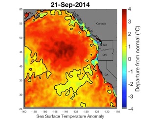
The Coastal Endurance, the Regional Cabled, and the Global Station Papa Arrays were key in identifying and monitoring the approach of a marine heatwave known as the “Blob” and its links to multiple ecosystem impacts on the US west coast.
Read MoreApplications Open for June Northeast Pacific OOIFB Workshop
The Ocean Observatories Initiative Facility Board (OOIFB) will host a workshop focusing on current and future science that can be addressed using data from OOI’s infrastructure in the Northeast Pacific and other regional observatory arrays. The workshop will be held at the OSU Portland Center in Portland, OR on June 7-9, 2022. This workshop was scheduled to be held in 2020, but was postponed due to the COVID-19 pandemic. The OOIFB is hopeful that in June 2022 members of OOI’s community can safely come together for a productive workshop. A hybrid model with in-person along with options for virtual participation is planned.
The workshop is aimed at researchers who are using or are considering using OOI data; resource managers from national, state, and tribal agencies; and educators at all levels interested in using data from the OOI’s Regional Cabled, Coastal Endurance, and Global Station Papa Arrays.
The workshop will inform the research community of the available data and science opportunities offered by the OOI and other observatory arrays located in the Northeast Pacific. An overview of OOI data products, user interfaces, and system features will be provided along with hands-on demonstrations using data access tools. OOI Program Team members and NSF representatives will be on hand to answer questions and provide information on OOI operations.
The workshop will provide a forum to facilitate science collaborations, identify strategies for engaging future users of OOI, and build cross-network collaborations. Community-building and expanding broader impacts will be discussed. Workshop participants will have the opportunity to provide feedback on their experiences in working with the OOI systems and data.
To apply for the workshop, please complete the on-line application form that is available on the workshop web page. Please indicate how you plan to participate in the workshop (in person or virtual) when completing the form. Travel support is available, but limited. Broad representation from institutional, geographic, and disciplinary groups is desired and will be considered in participant selection. The deadline for applications is March 20, 2022.
Additional details about the workshop and agenda are available here.


