
Archive for 2023
Water Sample Data Available thru BCO-DMO Repository
Hydrographic sampling performed by the Ocean Observatories Initiative (OOI) as part of each Array turn represents a significant collection of valuable physical, chemical, and biological information. In addition to the CTD (conductivity, temperature, depth) casts themselves, collected hydrographic data from bottle samples include discrete oxygen, salinity, nutrients (nitrate, nitrite, silicate, phosphate, ammonium), chlorophyll, and carbon system measurements. These data are subsequently merged into a concatenated “discrete summary” file with quality assessment flags and an associated readme file detailing important notes about the data. Although the primary purpose of these data are for the evaluation and validation of deployed OOI instrumentation, the annual (Global) or biannual (Coastal) collection of data at the same locations provides a unique time series of water properties following established community standards and methods.
Currently, OOI discrete water sampling data are made available via the OOI Alfresco Web Document Server and via the OOI Data Explorer. Water sampling data served through these platforms are organized so each dataset represents a single cruise at a specific Array.
Recent efforts within the ocean observing community have focused on improving FAIR (Findable, Accessible, Interoperable, Reusable) Data practices from programs and projects, such as the Marine Ecological Time Series (METS-RCN)-hosted international workshop on FAIR Data Practices for Ship-based Ocean Time Series. As part of the OOI’s effort to improve FAIR data practices, OOI is working with the Biological & Chemical Oceanography Data (BCO-DMO) Management Office to make the water sampling data collected during OOI operation and management cruises available via the BCO-DMO website and database. BCO-DMO curates publicly available research-ready oceanographic data in accordance with FAIR data principles.
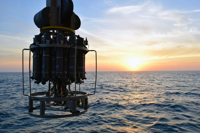
[media-caption path="https://oceanobservatories.org/wp-content/uploads/2023/08/CTD_at_sunset-640x427-1.jpg" link="#"]A CTD Rosette frame being lowered into the Atlantic Ocean from the R/V Neil Armstrong at sunset. Credit: Rebecca Travis © WHOI.[/media-caption]Re-distributing OOI data through BCO-DMO will enhance the FAIR qualities of OOI Discrete CTD and water sample data by: (1) providing a robust version control strategy that assigns DOIs (Digital Object Identifiers) as these datasets are updated; (2) making the data available to a larger audience, for use in novel science research beyond the intended scope of instrument validation; (3) concatenating the cruise-by-cruise data into a single dataset that is more readily available for analysis; and (4) providing machine-to-machine interoperability by making data available through an ERDDAP server.
Starting from the BCO-DMO home page, OOI water sampling data will be available as part of the “OOI Program Page” as the project “OOI Discrete CTD and Water Sampling Cruise Data.” Within the BCO-DMO data management system, water sampling data for each array will be organized into a single, concatenated data table. For example, the OOI Argentine Basin CTD and Water Sampling Data, which spans all four Argentine Basin mooring turn cruises (AT26-30, AT39-03, NBP1510, NBP1609) from 2015-2018, are currently available here.
This distribution of OOI data is but one example of OOI’s continuing quest to make its data available in multiple ways so that the data are broadly used to advance understanding of ocean processes.
Read More
OOIFB Town Hall at Ocean Sciences Meeting: Feb 20
~ Announcement ~
OOI Facilities Board Town Hall at the 2024 Ocean Sciences Meeting
February 20, 2024, 12:45 – 1:45pm Central Time
The Ocean Observatories Initiative Facilities Board (OOIFB) will host a Town Hall at the 2024 Ocean Sciences Meeting on Tuesday, February 20, 2024, from 12:45 pm to 1:45 pm Central Time. The community will have the opportunity to hear the latest information about the Ocean Observatories Initiative (OOI) facility, including an update on the relocation of the Pioneer Array; learn about NSF updates; and meet the OOIFB members. The second half of the Town Hall will consist of an interactive, panel discussion- Enhancing your Science with OOI Data: A Community Discussion about Maximizing OOI Data Use. The goal of this community-focused conversation is to discuss how current OOI data access and usage can be refined and/or expanded to better meet research and education goals.
Do you have initial questions and/or input about OOI data? Please provide it here, and your comments/questions will help shape the interactive panel discussion.
The OOIFB Town Hall is aimed at researchers and other stakeholders who are now using or are considering using OOI data, researchers interested in adding instrumentation to the OOI infrastructure, and educators at all levels interested in the OOI. For the Town Hall agenda, once available, and additional details, please visit here.
- Event: Ocean Observatories Initiative Facility Board (OOIFB) Town Hall (TH23L)
- When: Tuesday, 20 February 2024: 12:45 – 13:45 CST (*please note: the time listed on the online program may say 13:45-14:45, however, if you hover over the time, the actual, local CST schedule appears)
- Where: Room: 220-222, Second Floor, Ernest N. Morial Convention Center, Convention Center, New x
Pioneer Student Boat Crossed Atlantic 3X
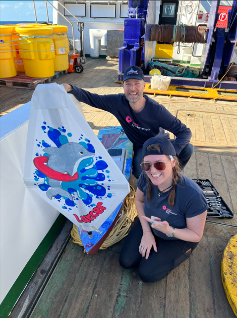
Seven years ago, the scientists and crew on the research vessel Neil Armstrong released a mini boat built by students at Quaker Elementary School and Waterford High School in Waterford, Conn. Earlier this year, the Lancer mini boat completed its crossing of the Atlantic. The boat’s third voyage started in December 2022, off the coast of Tenerife, Spain, and ended in The Bahamas on Earth Day, April 22, 2023.
The boat was made from a kit in 2016, made multiple ocean crossings and was highlighted on a BBC2 Documentary. This remarkable journey and story will be celebrated in a 30-minute webinar, December 18 at 8 am, including highlighting the contributions of many who helped along the way. It is free and open to the public with registration here. For those who missed the webinar live, you can view it here.
[media-caption path="https://oceanobservatories.org/wp-content/uploads/2023/12/Screenshot-2023-12-18-at-11.04.07-AM.png" link="#"]The Lancer was launched on from the R/V Neil Armstrong for its first trans-Atlantic crossing on May 7, 2016. Credit: Ken Kostel © WHOI.[/media-caption]This science project, started by a student named Kaitlyn in 2016, has since connected individuals across five countries. The Lancer and sister ships are part of Educational Passages, with a mission of connecting people around the world to the ocean and each other through unique global experiences such as their mini boat program. Students build the mini boats that drift with currents and follow their progress using GPS.
In November 2022, the Pioneer 19 team and crew of the R/V Neil Armstrong launched a sister ship and drifter, Lady Lance. This boat was recovered in the Azores in May 2023.
[media-caption path="https://oceanobservatories.org/wp-content/uploads/2023/12/lancer_OCT.png" link="#"]The student-built drifter mini boat Lancer was recovered in the Bahamas after its third Atlantic voyage. Credit: Educational Passages. [/media-caption]Read More
Ocean Data Labs Mini-Workshop at OSM24
On Wednesday, February 21st, the Ocean Data Labs will host a “mini” workshop for professors interested in learning about the Ocean Observatories Initiative (OOI) and how they can utilize OOI data to support the teaching of oceanographic concepts and data literacy to undergraduate students.
The workshop will introduce faculty to the community-developed collection of OOI Data Explorations and the online OOI Lab Manual. Participants will learn how these resources can be integrated into introductory oceanography (or similar) courses to support student learning.
This OOI Data Labs workshop will be held from 10:30am to 3:30pm, in a hotel next to the New Orleans Convention Center, making it easy for attendees to participate in both the workshop and the meeting. OSM registration is not required to attend the workshop. Space is limited, so please apply early.
For more information and to apply, please visit 2024 OOI Data Labs Workshop page.
Read MoreCall for Additional Ocean Observations
In a widely distributed editorial opinion piece, Peter de Menocal, president and director of the Woods Hole Oceanographic Institution, and Margaret Leinen, vice chancellor for marine science and director of the Scripps Institution of Oceanography/University of California San Diego, explain why the ocean can be seen as our greatest ally in tackling climate change. They cite the importance of ocean observing systems like the Ocean Observatories Initiative (OOI), the ARGO Program, and ship-based operations, including those supported by the global GO-SHIP expeditions.
Read about how OOI and others are contributing vital data to understanding the changing ocean.
https://oceanographicmagazine.com/features/the-ocean-our-greatest-ally-in-tackling-climate-change/
http://digital.oceannews.com/december-2023/page-1?m=9767&i=810338&p=14&_ga=2.249360967.1538107420.1702656208-1663532955.1702656207&ver=html5
Read More
OOI at AGU 2023
[media-caption path="/wp-content/uploads/2023/10/IMG_1078-scaled.jpg" link="#"]OOI at booth #220 in the exhibit hall at AGU this year. Stop by and say hello! [/media-caption]
OOI will be at booth #220 at the AGU Fall Meeting 2023 in San Francisco from December 12-16. The following is a compilation of OOI-related presentations at this year’s fall meeting. If we’ve missed any OOI-related sessions, please contact dtrewcrist@whoi.edu and we will be happy to add them. Hope to see you in person this year! Share your AGU news at #AGU23.
Monday, 11 December 2023
14:10- 18:30 PST(17:10 – 21:30 EDT) Poster Hall A-C – South (Exhibition Level, South, Moscone Center)
Board 0501: Analyzing the Magnetic Signals of Tsunami Waves Using a Long-Term Seafloor Magnetometer Observatory
Neesha R Schnepf, Laboratory for Atmospheric and Space Physics, Christine J Chesley, Lamont-Doherty Earth Observatory, Deborah S Kelley, University of Washington, Dana Manalang, University of Washington, Applied Physics Laboratory, Hiroaki Toh, Kyoto University, Takuto Minami, Kobe University, and Manoj C Nair, University of Colorado, Boulder, United States
16:20- 16:30 PST(19:20 – 19:30 EDT) 153 – South (Upper Mezzanine, South, Moscone Center)
V14B-03 – Characterizing seismic and acoustic signals at Axial Seamount with unsupervised machine learning
Kaiwen Wang, Lamont-Doherty Earth Observatory, Columbia University; Felix Waldhauser, Columbia University; Maya Tolstoy, University of Washington, William S D Wilcock, University of Washington, Theresa Sawi, Lamont-Doherty Earth Observatory, Columbia University; David Paul Schaff, Lamont-Doherty Earth Observatory, Columbia University; and Yen Joe Tan, The Chinese University of Hong Kong
15:00-18:00 CST Exhibit Hall – Visit OOI’s Booth #220
Wednesday, 13 December 2023
16:45 – 16:55 PST (19:45 – 19:55 EDT) 153 – South (Upper Mezzanine, South, Moscone Center)
V34B-05 – Dynamic magma movements beneath the Axial Seamount revealed a new eruption precursor
Youyi Ruan, Nanjing University, School of Earth Science and Engineering; Li Wang, Nanjing University, School of Earth Science and Engineering and Qin Wang, School of Earth Sciences and Engineering, Nanjing University
14:10 – 18:30 PST (17:10 – 21:30 EDT) Poster Hall A-C – South (Exhibition Level, South, Moscone Center)
Board 1602: A Total Water Level Model Testbed on the US West Coast
David Honegger, Oregon State University, Carter Howe, Oregon State University, Jay Merrill, Oregon State University, Carson WilliamsOregon State University, David Hill Oregon State University, Merrick C Haller, Oregon State University,and Peter Ruggiero, Oregon State University,
10:00-18:00 CST Exhibit Hall – Visit OOI’s Booth #220
Thursday, 14 December 2023
08:39 – 08:42 PST (11:39 – 11:42 EDT) eLightning Theater V, Hall D – South (Exhibition Level, South, Moscone Center)
V41G-04 – Is Axial Seamount just napping? An update on the latest inflation and seismic data
William W. Chadwick Jr, Oregon State University, William S D Wilcock, University of Washington, Scott L Nooner, University of North Carolina at Wilmington, and Jeffrey W Beeson, Oregon State University
11:12 – 11:22 PST (14:12 – 14:22 EDT) 158 – South (Upper Mezzanine, South, Moscone Center)
G42A-06 – An Acoustic Array at Axial Seamount for Geodesy and Autonomous Vehicle Support
Maleen Kidiwela, University of Washington, School of Oceanography, Dana Manalang, Applied Physics Laboratory, University of Washington, William S D Wilcock, School of Oceanography, University of Washington, and Jake Ploskey, Applied Physics Laboratory, University of Washington
14:10 – 18:30 PST (17:10- – 21:30 EDT) 158 – Poster Hall A-C – South (Exhibition Level, South, MC)
OS43D-1823 Investigations of Air-Sea Interaction Using Surface Flux and Wave Data from the Ocean Observatories Initiative (OOI)
James B. Edson, Woods Hole Oceanographic Institution, Douglas C Vandemark, University of New Hampshire, and Marc Emond, University of New Hampshire
10:00-18:00 CST Exhibit Hall – Visit OOI’s Booth #220
Friday, 15 December 2023
08:30 – 12:50 PST (11:30 – 15:50 EDT) Poster Hall A-C – South (Exhibition Level, South, Moscone Center)
Board 0595: MonitorMyOcean.com: Transforming Research into an Interactive Web Application to Raise Awareness on Ocean Noise Pollution Among Youths and Citizen Scientists
Artash Nath, Founder, MonitorMyOcean.com
14:10 – 18:30 PST (17:10 – 21:30 EDT) Poster Hall A-C – South (Exhibition Level, South, Moscone Center)
Board 0189: Offshore Seismic Signals of Deformation in the Shallow Cascadia Subduction Zone
Zoe Krauss, University of Washington, William S D Wilcock, University of Washington, and Kenneth C Creager, University of Washington
15:20 – 15:30 PST (18:20 – 18:30 EDT) 157 – South (Upper Mezzanine, South, Moscone Center)
S53B-08 – Real-time Production and Analysis of High-Precision, Deep Magnitude Earthquake Catalogs
Felix Waldhauser, Lamont-Doherty Earth Observatory, Columbia University, Kaiwen Wang, Lamont-Doherty Earth Observatory, Columbia University, Eric Beauce, Lamont-Doherty Earth Observatory, Columbia University, David Paul Schaff, Lamont-Doherty Earth Observatory, Columbia University, Theresa Sawi, Lamont-Doherty Earth Observatory, Columbia University, and Benjamin K Holtzman, Lamont-Doherty Earth Observatory, Columbia University
10:00-13:00 CST Exhibit Hall – Visit OOI’s Booth #220
Read MoreDemo of Data Explorer New Features Video Available

In case you missed the latest demonstration of the newest features of Data Explorer, you can watch it here. Axiom Data Science Senior Software Engineer Brian Stone and OOI’s Senior Manager of Cyberinfrastructure Jeffrey Glatstein explain the latest additions to Data Explorer include a beta display of high-definition video streams, additional differentiation between the Axial Seamount and Oregon Margin Regional Cabled Array Assets, human-in-the-loop quality control flag display, and two ADCP instruments that were previously not visualized.
[embed]https://youtu.be/BcMi3lHSUB0[/embed] Read MoreNew OOI Documentary Premiered at COP28
A nine-minute documentary about OOI’s work and why it is important premiered at COP28 on November 30, 2023. It will be shown daily throughout this important climate conference which runs through December 12. The documentary was produced by One World Network, a science and technology multi-channel media company, in association with the OOI. The documentary features 20+ OOI scientists and engineers, along with stunning imagery that illustrates their stories. Please have a look and feel free to share it with your friends, colleagues, and others who may be inspired to use OOI data in their research and classrooms.
[embed]https://youtu.be/ds6GwHoIa-0?si=e53fYK5g_LxJ6NS9[/embed] Read MoreDemo of Latest Data Explorer Features Dec. 6
Join Axiom Data Science Senior Software Engineer Brian Stone and OOI’s Senior Manager of Cyberinfrastructure Jeffrey Glatstein as they demonstrate the latest features of Data Explorer and answer your questions about how you might use their features in your research. The latest additions to Data Explorer include a beta display of high-definition video streams, additional differentiation between the Axial Seamount and Oregon Margin Regional Cabled Array Assets, human-in-the-loop quality control flag display, and two ADCP instruments that were previously not visualized.
This virtual town hall is an opportunity to have your questions answered and share feedback. Be sure to mark your calendar and attend.
- OOI Virtual Town Hall
- Wednesday December 6, 2023
- 1 pm Eastern
- Please register here.
Read More
Biofouling Mitigation from Top to Bottom
OOI operates its arrays in challenging environments. At the sea surface, sea lions find the buoys attractive resting spots. At the bottom, instruments must collect data under varying temperatures at intense pressures. And, then throughout the water column’s photic zone is marine growth. Marine life finds OOI’s instrumentation and arrays irresistible, where it attaches and grows like gangbusters.
The folks who keep OOI’s arrays operational explain the conditions this way:
“Putting any kind of instrumentation – electrical or scientific instrumentation – in the water for a year or more at a time is always a challenge, said Dana Manalang, Engineer, OOI Regional Cabled Array (RCA). “It’s a harsh environment due to the high pressures and salt water so getting systems to operate sub-seas is the largest challenge we face.”
“It’s a challenging place to work,” concluded Coastal Endurance Array Project Manager Jonathan Fram, “And, we are very thankful to have the opportunity to make stuff that can survive in just about any marine environment.”
So how do they do it? OOI engineers develop creative ways to tackle the many challenges, particularly in terms of some of the peskier, persistent ones like keeping marine growth, referred hereafter as biofouling, at bay.
Diaper cream as a solution
Coastal and Global Scale Node (CGSN), Coastal Endurance, and RCA team members have implemented novel ways to minimize and in-situ clean marine growth on sensors, gliders, and components of the arrays that spend up to 12 months in the water.
One such novelty is the application of diaper cream. An inexpensive and convenient form of zinc oxide, diaper cream, has been used for decades as a marine anti-foulant, with moderate effectiveness. . “Its application for oceanographic equipment goes back at least to the 1990’s, and is considered non-toxic relative to other concoctions, “ explained Peter Brickley, CGSN Observatory Operations Lead. Other anti-fouling scheme exist, but some are expensive, some add weight, while others take too long to apply and don’t fit into the team’s operational deployment plans.
“The only downside is that diaper cream has be to done onboard right before deployment, or it’s a mess,” he added.
Coastal Endurance Project Manager Jonathan Fram said, “One key issue is that gliders are made of aluminum, so we can’t use copper-based antifouling material on them. Diaper cream is zinc-based, so it won’t corrode gliders’ aluminum.” The Coastal Endurance Team regularly applies diaper cream to its glider fleet, with measurable success. “Gliders with barnacles on them can’t swim straight or efficiently. The diaper cream provides a protective coating to which marine growth cannot readily adhere. It helps keep our gliders moving easily through the water and reporting data.”
[media-caption path="https://oceanobservatories.org/wp-content/uploads/2023/12/Diaper-cream-117.jpg" link="#"]Coastal Endurance team members Raelynn Heinitz and Alex Wick apply diaper cream before launch of a glider off the Oregon coast. The ointment prevents marine growth on gliders that traverse the shallow coastal waters near the Endurance Array’s Washington and Oregon-Newport lines. Marine organisms thrive in the shallow water where sunlight can penetrate, aiding marine growth. Credit: Kathy Hough, NOAA.[/media-caption] [media-caption path="https://oceanobservatories.org/wp-content/uploads/2023/12/without-diaper-cream.jpg" link="#"]Shown above is a recovered glider having spent three months in the upper coastal waters off the Washington coast. It would have been covered with marine life, imperiling its ability to maneuver, but the protective diaper cream kept most of them at bay. Credit: Kathy Hough, NOAA.[/media-caption]After being successfully tested on gliders, the Coastal Endurance Array and RCA teams then tried the protective diaper cream as an option to keeping acoustic transducers on the arrays clean, as suggested by the vendor. An acoustic transducer is an electrical device that vibrates, producing sound waves in water. OOI uses transducers in both echosounders and hydrophones. Here, too, the diaper cream proved to be an inexpensive and effective biofouling mitigation measure.
[media-caption path="https://oceanobservatories.org/wp-content/uploads/2023/12/acoustic-transducer.jpg" link="#"]An acoustic transducer covered with diaper cream to prevent biofouling during its six-months in the water. Credit: Kathy Hough, NOAA.[/media-caption]Addition of UV lights
Putting ultraviolet lights in the water to discourage marine growth is another proven biofouling mitigation measure. Early on, the Coastal Endurance team deployed two oxygen optodes, which measure dissolved oxygen, side-by-side at seven meters depth on the Oregon Shelf Surface Mooring with a UV light pointed at one of them. Data from the two sensors tracked each other for six weeks after which the unprotected sensor fouled. Within weeks, there were daily afternoon spikes of up to twice the oxygen level of the protected sensor, with slightly lower measurements than the unprotected sensor at night due to respiration of the biofilm. Since this test, optodes are regularly deployed with UV lights to aid their operation. (Annotations of OOI moored oxygen data note when a UV light was not operating with it.)
Following the success of the UV-light on dissolved oxygen sensors, the CGSN team tested this antifouling measure on a moored Coastal Pioneer Array spectral irradiance (SPKIR) sensor, which measures the amount of light energy that reaches a surface. The testing was conducted with Sea Bird Scientific, the SPKIR vendor. The vendor confirmed that the UV light did not damage the instrument’s optics nor did it interfere with its light measurements. After this confirmation and positive result, UV lights are now used on all SPKIR sensors on Surface Moorings, Coastal Surface Piercing Profilers, and uncabled digital still cameras moored at less than 70 meters. The teams adjust the on/off cycle of the UV lights so that biofouling is prevented without damaging the sensors, interfering with measurements, or using too much power.
[media-caption path="https://oceanobservatories.org/wp-content/uploads/2023/12/Screenshot-2023-11-27-at-6.02.17-PM.jpeg" link="#"]Sea Bird Scientific’s spectral irradiance sensor needs to be clean to effectively measure light energy in the water column. Shining UV lights on these sensors helps to minimize biofouling and clouding of the sensor.Credit: Sea Bird Scientific.[/media-caption]Lens-Cleaning Brushes
The RCA also has adopted novel ways to deal with biofouling on the Pacific Ocean seafloor. RCA operates and maintains a high-definition (HD) video camera (CAMHD) at the base of an actively venting hydrothermal chimney called “Mushroom” (see below) in the ASHES vent field of Axial Seamount Caldera. Live HD video of this > 4-m high chimney and surrounding seafloor is streamed to shore on an automated schedule for 14 minutes at 3-hour intervals, with longer non-stop monitoring for 24 hours twice a month and 72 hours at the beginning of each month.
[media-caption path="https://oceanobservatories.org/wp-content/uploads/2023/12/Figure-a.jpg" link="#"]RCA’s high-definition video camera installed next to “Mushroom” hydrothermal chimney in the ASHES vent field of Axial Caldera. Credit: UW/NSF-OOI/WHOI; J2-1534, V23.[/media-caption]The scene is fully scanned with programmable pan, tilt, and zoom functions of this instrument, which provides detailed imagery of the high-temperature water spigots, sea spiders, lipets tube worms and other biota covering both the chimney and surrounding lava-covered seafloor.
[media-caption path="https://oceanobservatories.org/wp-content/uploads/2023/12/Figure-b.jpg" link="#"]Close-up of the RCA HD video camera at the base of “Mushroom” hydrothermal chimney. Credit: UW/NSF-OOI/WHOI; J2-1534, V23.[/media-caption]Unfortunately, such live subjects, microorganisms, and other organic/inorganic processes often deposit a film on the camera lens which interferes with visualization. To ensure optimal clarity of HD video between site maintenance visits during annual RCA operation and maintenance expeditions, an automated lens cleaning protocol using a simple brush, installed on the instrument’s frame in the front of the lens has been instituted.
[media-caption path="https://oceanobservatories.org/wp-content/uploads/2023/12/Figure-c-.png" link="#"]Lens-cleaning brush, indicated by red arrow, installed in front of RCA’s HD video camera and used during an automated cleaning protocol. Credit: UW/NSF-OOI/WHOI; J2-1534, V23..[/media-caption]This programmed event occurs three times a month and tilts the camera down and pans it left and right, allowing the brush to gently clean the lens. The video streaming and lens cleaning schedules can be optimized remotely from shore by RCA personnel to provide the highest scientific and educational value from the HD video.
Eco Anti-fouling paint
Ever wonder why OOI’s buoys are painted blue? This eco-friendly paint serves the same purpose as diaper cream and UV lights—to minimize marine growth on the buoys and its metal components. The teams use a commercially available water-based and copper-free anti-fouling paint. Once recovered, the CGSN and Coastal Endurance Array components are taken apart and refurbished so they function like new once ready to be redeployed. All metal components and float areas are cleaned and receive a fresh coat of paint in the hope of diminishing their attractiveness to life below the surface.
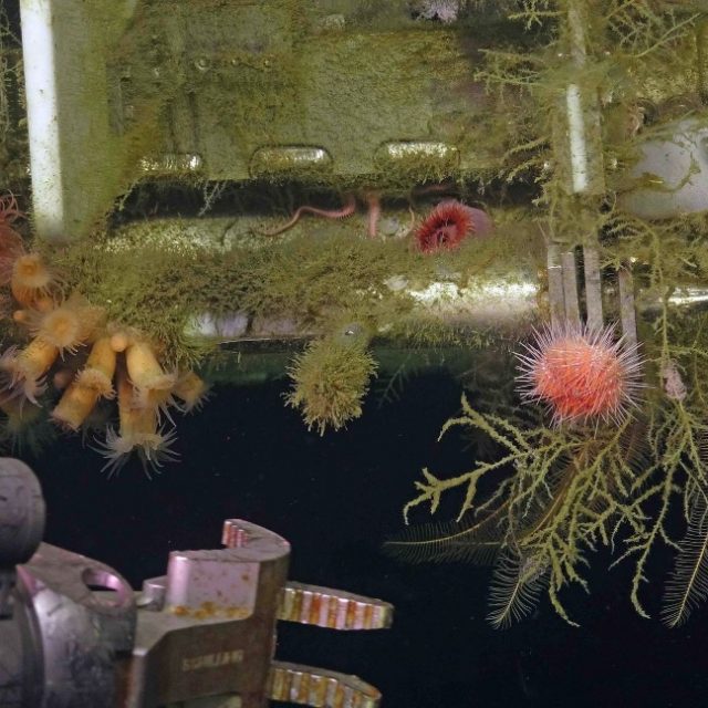
[media-caption path="https://oceanobservatories.org/wp-content/uploads/2023/12/predeployment.png" link="#"]Pre-deployment: The Coastal Pioneer buoys assembled, painted and ready for deployment for six months in the Atlantic Ocean, off the coast of Martha’s Vineyard. Credit: Derek Buffitt © WHOI.[/media-caption] [media-caption path="https://oceanobservatories.org/wp-content/uploads/2023/12/Biofouled-mooring-in-air-2023-03-17-13-33-17-2.jpg" link="#"]After six months in the northeast Pacific, the Coastal Endurance Surface mooring buoy had become a rich habitat for marine life. Credit: Kim Kenney, OSU.[/media-caption] [media-caption path="https://oceanobservatories.org/wp-content/uploads/2023/12/Pink-sea-urchins.jpg" link="#"]Biofouling can be beautiful, as demonstrated here as the ROV Jason prepares to recover the RCA Shallow Profiler during its annual operations and maintenance expedition. Credit: UW/NSF-OOI/WHOI; J2-1516: v23.[/media-caption]
Read More