
Posts by ooistaff
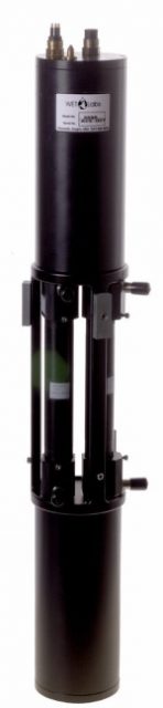
New Controller Latest in OOI Innovations
Having equipment in the water around the clock for six months at a time provides many challenges for the land-based OOI engineering team charged with keeping the equipment operational so there is a continual flow of data to shore. Maintaining consistent, reliable power for the ocean observing equipment is at the top of this list of challenges.
OOI’s data-collecting instruments attached to the moorings run on batteries charged by renewable wind and solar energy. OOI is in the process of replacing the current solar panels with new panels that are more efficient at generating energy, even when shaded. To supplement this upgrade, the OOI arrays are also being outfitted with a brand-new solar controller to manage the energy going into the batteries. Like with the new solar panels, OOI engineers looked for a controller that was available commercially for easier repair and replacement.
“What was important to us was finding a way to use these new solar panels in the best, most optimal way,” said Woods Hole Oceanographic Institution (WHOI) engineer Marshall Swartz. “We looked for a company that would help us specify and build a customized algorithm for a controller that would optimize the functionality of the panels by taking into account battery temperatures.”
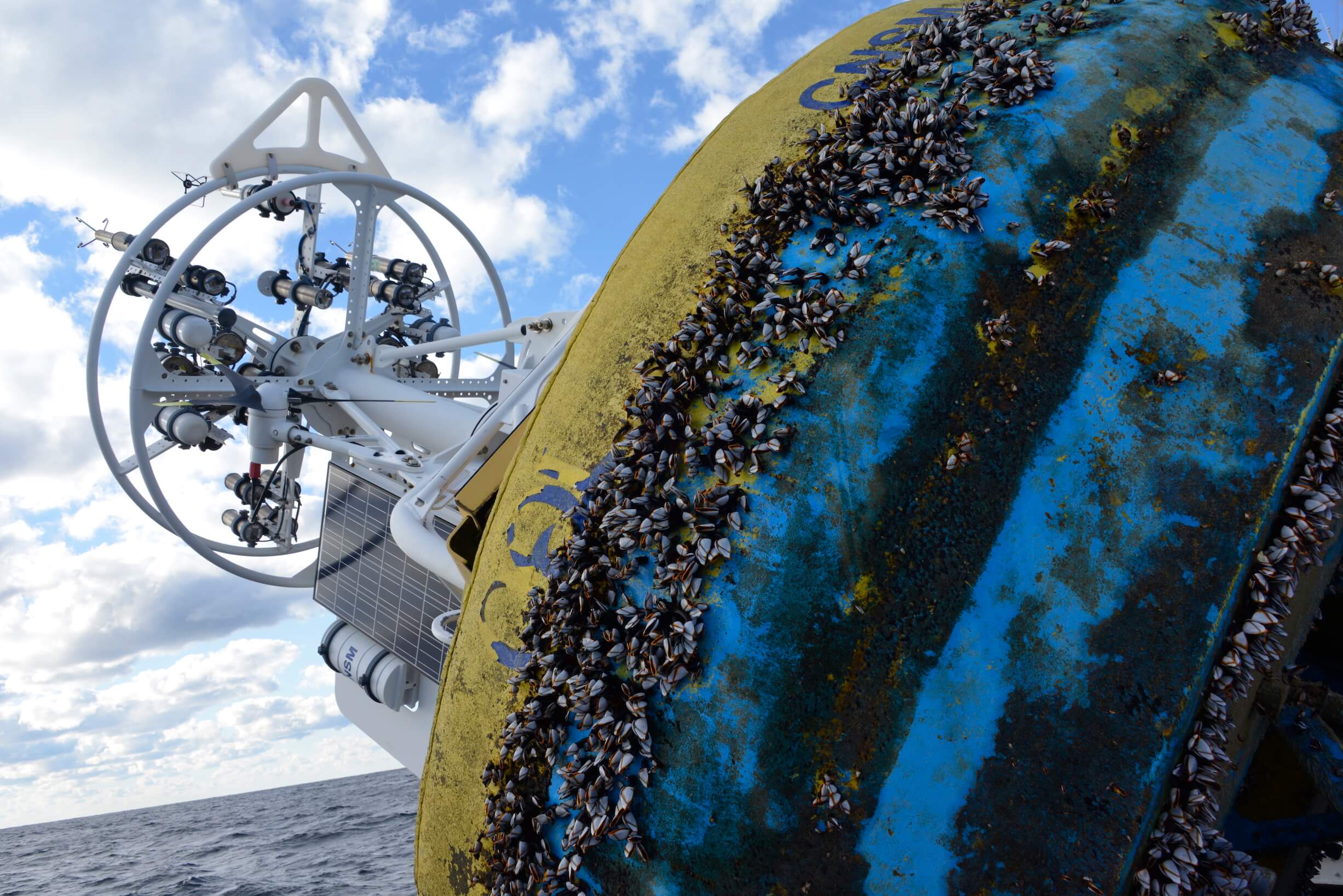
[media-caption path="/wp-content/uploads/2021/12/DSC0486-2.jpeg" link="#"]Buoys get quite the workout when they are in the water for six months and more. Powered by wind, solar, and batteries, OOI has recently improved the way energy from the solar panels is managed with new controllers. Credit: ©WHOI, Darlene Trew Crist. [/media-caption]
Some larger, older controllers can consume up to 3-5% of the energy coming into the device, but the new controller is smaller and more efficient, helping to optimize the amount of energy harvested.
Temperature conditions play a big role in how effectively the energy is managed. Changing battery temperatures require the controller to adjust its charge settings to maintain battery life and capacity. The controllers used on OOI moorings sense battery temperature and automatically adjust to assure best conditions to assure reliable operation.
“It’s really essential for us to maintain the proper charge levels for existing temperature conditions,” said Swartz. The OOI buoys encounter a wide range of temperatures: from subfreezing temperatures up to 40°C (over 100°F) when a buoy is sitting in the parking lot before it is deployed. When the buoys are deployed, water temperatures can vary widely from -1 to 33°C (~30 to 91°F), depending on seasonal conditions.
The new controller automatically regulates the amount of electricity going into the battery under such varying temperature conditions. If the wind turbines are generating more energy than the battery needs, for example, the controllers direct excess power into an external load that dissipates heat and adds resistance to the spinning of the wind turbines, preventing the turbines from spinning too fast, possibly damaging their bearings.
“As parts of the OOI infrastructure need replacing or to be upgraded, this offers us the opportunity to find more efficient, and often times, off-the-shelf, less-expensive replacements that will help us keep the arrays functioning and data flowing,” Swartz said. “It’s a winning combination for all parts of the operation.”
Read More
Abstracts Welcome for OSM Session on California Current and NE Pacific Ocean
Abstracts are being sought for a session on data and modeling of the California Current System and the Northeast Pacific Ocean during the 2024 Ocean Science Meeting in February in New Orleans. Edward P. Dever, Oregon State University, Richard K. Dewey, Ocean Networks Canada, and Kashish Sadhwani, Indian Institute of Technology Bombay organized the session to maximize use of modeling efforts in the region and to foster further collaboration among researchers.
“The Northeast Pacific Ocean offers researchers opportunities to study many regionally important processes that impact productivity, seasonal hypoxia, and ocean acidification,” said Edward P. Dever, of Oregon State University, who is chair of the session. “We hope to bring researchers together to share their insights about this important region and to help facilitate collaboration among those working in different areas of the Northeast Pacific.”
The deadline for abstract submission is September 13, 2023. Submit here. A description of the session follows:
OT019 – Sustained Data and Models in Support of Research in the California Current System and Northeast Pacific Ocean
The Northeast Pacific Ocean as defined by the California Current System, Salish Sea, and Gulf of Alaska, has long been a focus of sustained observing and modeling efforts. Regionally important physical processes include coastal upwelling, river plumes, and responses to interannual variability (e.g., ENSO, the Pacific Decadal Oscillation, marine heatwaves, and other events). These processes impact primary productivity, phyto- and zooplankton community structures, seasonal hypoxia, and ocean acidification. In this session, we seek to share insights and facilitate collaboration between observations and models and among researchers working in different areas of the Northeast Pacific. We invite contributions in any of the following broad topics:
- syntheses of sustained data sets for model initialization
- forcing and validation
- best practices for inter comparison and networking across observations
- modeled and observed interactions between different sub-regions
- estimation of rate processes
- advances in bio-acoustic, biogeochemical, and bio-optical measurements, and
- predictions of physical and ecosystem responses across relevant temporal and spatial scales.
Read More
Sensor Summer School Curriculum and Video Available
The Ocean Observatories Initiative Facility Board (OOIFB) hosted a 2023 summer school (July 17-21, 2023) at Oregon State University in Corvallis, Oregon that focused on OOI optical attenuation and absorption data. A mix of advanced graduate students, post-doctoral fellows, and early career scientists participated in this hands-on learning experience about how to access, analyze, and interpret data from the Sea-Bird AC-S. Data from the AC-S is used to characterize the absorption and scattering of light in seawater, which provides information on phytoplankton biomass in the measured ocean region.
So others may benefit from what was learned, the curriculum is available online here.
Read More
Spreading Curiosity about Ocean Science with Summer Visitors
Summertime brings students from all over the country to Woods Hole, Massachusetts to learn about ocean science. June and July 2023 were particularly busy, with the Coastal and Global Scale Nodes (CGSN) division of the Ocean Observatories Initiative (OOI) at Woods Hole Oceanographic Institution (WHOI) hosting four different student groups. CGSN offers student tours of OOI facilities and the chance to talk directly with an ocean scientist or engineer. They engage with students this way in the hope of increasing student interest in marine science and possibly encouraging them to pursue an ocean-related career. During the tours and presentations, students learn about the moorings and vehicles OOI deploys throughout the year and the dissemination of ocean data collected. These hands-on experiences give student visitors the opportunity to see the full scale and complexity of OOI operations.
UMass-Dartmouth REU Students Visit
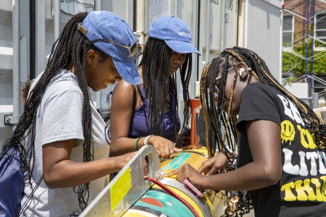
On June 26, 12 community college engineering student and faculty from a National Science Foundation (NSF) sponsored Research Experience for Undergraduate (REU) at the University of Massachusetts, Dartmouth (UMass-Dartmouth) visited OOI. CGSN staff provided a tour of their operations, including ocean-observing equipment stored outdoors because of its size.
[media-caption path="https://oceanobservatories.org/wp-content/uploads/2023/07/Sheri-with-REUs.jpg" link="#"]CGSN team members, Dr. Sheri White (blue jeans to right) and Irene Duran (next to Dr. White) gave a tour to UMass-Dartmouth REU students. Photo by: Kama Theiler © WHOI.[/media-caption] [media-caption path="https://oceanobservatories.org/wp-content/uploads/2023/07/Colin-Dobson-with-REU.jpg" link="#"]A UMass-Dartmouth REU student asks CGSN glider expert Colin Dobson a question regarding the gliders he works on. Photo by: Kama Theiler © WHOI.[/media-caption]PEP Students Visit
In early July, the CGSN team gave a presentation to Woods Hole Partnership Education Program (PEP) participants, who spend 10-weeks in Woods Hole at WHOI, the Marine Biological Laboratory, Woodwell Climate Research Center, National Oceanic and Atmospheric Administration’s Northeast Fisheries Science Center, Sea Education Association, or the United States Geological Survey’s Woods Hole Coastal and Marine Science Center. The PEP program is designed primarily for college juniors and seniors from underrepresented groups in marine and ocean sciences who want to spend a summer gaining practical experience in marine and environmental science.
Summer 2023 is the 15th summer of the PEP program in Woods Hole. Many former PEP students have returned to Woods Hole and WHOI both as students and professionals (including CGSN’s Irene Duran). Benjamin Harden, PEP professor, stated that OOI’s community outreach is a “great way for these students to hear about the frontiers of oceanography and really helped many of them frame possible careers in the field.”
Black Girls Dive Foundation Visit
July 25th, CGSN’s Electrical Team provided a workshop to the Black Girls Dive Foundation (BGDF) program participants. BGDF provides the space and opportunity to empower young black women to explore their STEM (Science, Technology, Engineering and Mathematics) identity through marine science and conservation, and SCUBA diving. While visiting OOI, the BGDF students learned about pH and concerns about increasing ocean acidification. The students collected local sea water and with the help of the CGSN Instrument Team determined its pH with a probe they calibrated using a microcontroller.
[media-caption path="https://oceanobservatories.org/wp-content/uploads/2023/07/BGDF-with-AUV.jpg" link="#"]During their visit to WHOI, BGDF students had the opportunity to get up close to check out an Autonomous Underwater Vehicle (AUV). Photo by: Jayne Doucette © WHOI.[/media-caption] [media-caption path="https://oceanobservatories.org/wp-content/uploads/2023/07/Jennifer-with-BGDF.jpg" link="#"]CGSN Instrument Lead Jennifer Batryn (far left) shows how she checks OOI instruments operations on her laptop to one of the BGDF visitors. Photo by: Jayne Doucette © WHOI.[/media-caption]SEA Participants Visit
Also in late July a group of students participating in the Sea Education Association’s (SEA’s) High School program visited OOI’s Facility LOSOS on WHOI’s Quissett Campus. This is a study abroad program in Woods Hole for undergraduate, gap year, and high school students, that combines studies in ocean science with at-sea experiences. The students spent an afternoon learning about OOI, its operations, how data are collected and disbursed, and what scientists are learning from OOI data.
[media-caption path="https://oceanobservatories.org/wp-content/uploads/2023/07/Dee-and-Jon-With-SEA-students-2.jpg" link="#"]CGSN team members Dee Emrich (standing left) and John Lund explained OOI operations to high school students from the Sea Education Program. Photo by: Dr. Sheri White © WHOI.[/media-caption] [media-caption path="https://oceanobservatories.org/wp-content/uploads/2023/07/Irene-with-SEA-students.jpg" link="#"]CGSN Engineer Irene Duran (maroon top in center) showed mooring components to high school students from the Sea Education Program. Photo by: Paul Whelan © WHOI.[/media-caption] Read MoreSoundscape Ecology Through Automated Acoustic-Based Biodiversity Indices
Soundscape Ecology Through Use of Automated Acoustic-Based Biodiversity Indices: A Test Using RCA Broadband Hydrophone Data. Adapted by OOI from Ferguson et al., 2023.
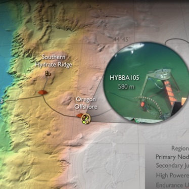
[media-caption path="https://oceanobservatories.org/wp-content/uploads/2023/07/Screenshot-2023-07-27-at-3.53.41-PM.png" link="#"]Figure a) Location of Regional Cabled Array broadband hydrophones used in this study. b) Acoustic Complexity Index associated with mammal calls, fish sounds, and anthropogenic noise. (After Ferguson et al., 2023).[/media-caption]Ferguson’s et al., 2003 paper explores the use of myriad biodiversity indices, generated by automated acoustic classifications, using data from three of the Regional Cabled Array (RCA) broadband hydrophones. As the authors point out, human in-the-loop evaluation of marine species and anthropogenic noise from very large data volumes generated by passive acoustic sensors is formidable. Yet, identification of marine organisms and anthropogenic noise is increasingly important for biodiversity conservation and ecosystem monitoring. Automated biodiversity indices have been utilized in terrestrial environments, but only limited studies have used machine learning to study soundscape ecology in marine systems. This study used broadband hydrophone (HYDBBA) data from Slope Base on the Shallow Profiler Mooring (200 m water depth and ~ 100 km offshore), at Oregon Offshore (580 m water depth and ~ 72 km offshore), and the Oregon Shelf site (80 m water depth and ~ 16 km offshore) (Figure 28a) to examine seven diversity indices. Note, these study sites are valuable to making progress in soundscape ecology because the Cascadia Margin is characterized by very high biological productivity impacted by the California current, it is the site of intense shipping lanes, and because of the availability of continuous, real-time acoustic data streams provide by the RCA.
In this initial study, Ferguson et al., evaluated one month of data from the three sites: January 2017 for HYBDDA 103 and 106 and April 2018 for HYBDDA 105. Five minute files were used with 7,101 files for Slope Base, 4,725 files for Oregon Offshore, and 6,410 files for the Oregon Shelf. Data from these instruments had been previously annotated, providing ground truthing for machine learning results. Periods of vocalization of marine mammals occurred less frequently at Slope Base. Three months of data were reviewed to examine periods of mammal vocalizations and anthropogenic sounds.
Identifying the relationship between numerous acoustic indices and species characteristics is complex and requires attention to a significant number of factors and computation of multiple tests, as described in detail in this paper. The Acoustic Complexity Index (ACI, Figure 28b), is generated from an algorithm to quantify biological sounds based on intensity, it is the most commonly used index to assess acoustic indices in marine systems, and has been demonstrated useful in identifying species diversity. Results from this work show that ACI measurements increased during vocalizations by dolphins and sperm whales. However, evaluation of the seven indices show that biodiversity cannot be explicitly determined from any single acoustic index. A significant finding from this study is that true assessment of large-scale ecosystem health and changes in indicator species, which may be due to differences in seasonal and interannual variability, requires co-located physical and chemical oceanographic data. The authors note that the RCA and Endurance Array instrumentation provides “an ideal scenario for accurately monitoring system health”.
_______________________________________________
Ferguson, E.L., H.M. Clayton, and T. Sakai (2023) Acoustic Indices Respond to Marine Mammal Vocalizations and Sources of Anthropogenic Noise. Frontiers in Marine Science. 10:1025464; doi: 10.3389/fmars.2023.1025464.
Read MoreThe Great Salinity Anomaly of 2015-2020
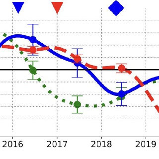
The Great Salinity Anomaly of 2015-2020. Adapted by OOI from Biló et al., 2022.
[media-caption path="https://oceanobservatories.org/wp-content/uploads/2023/07/Bilo-.png" link="#"]Figure: Time series of salinity anomalies from OSNAP moorings near the Reykjanes Ridge (RR) and within the western boundary current of the Irminger Sea (CF6), and from OOI Flanking Mooring (FLB) in the Irminger Sea (FLB). The eighteen-month low-passed anomalies are averaged between 0 and 200 m depth and computed relative to the mean of the moored data record. Error bars show 95% confidence intervals for annual salinity averages. The blue (red) triangles and diamonds represent the start and end of the freshening period in the CF6 (FLB) records, respectively.[/media-caption]Unusual surface freshening episodes in the Subpolar North Atlantic have been documented since the 1960s when the term Great Salinity Anomaly (GSA) was coined to refer to the first documented event (Dickson et al., 1988). GSAs are of great importance because the reduction in surface density of North Atlantic surface waters increases vertical stratification, suppresses deep water formation, and weakens the Atlantic Meridional Overturning Circulation (AMOC). Deep (700-1000 m) wintertime convection in the Irminger and Labrador Seas creates the water mass constituting the northern portion of the AMOC’s lower limb, which transports cold water back to southern latitudes. Thus, sustained changes to deep water formation due to a GSA will impact the global climate system.
New work by Bilo et al. (2022) argues that there has been another GSA during 2015-2020, with significant salinity reduction in the upper 200 m of the Iceland Basin and Irminger Sea. The authors use hydrographic data and moored observations to document the spatial extent and propagation pathways of the GSA.
Hydrographic data come from the Argo float monthly climatology and from UK Met Office Hadley Centre “enhanced” version 4 (EN4) historical hydrography. These spatial data sets allow the basin-wide salinity changes to be diagnosed, and show that between 2015 and 2020 the upper 200 m of the central Irminger Sea freshened by 0.1-0.2 PSU. The observed freshening rate of up to 0.04 PSU per year is among the fastest salinity decreases ever recorded in the region. The regional maps show the freshening first in the Iceland Basin and later in the Irminger Sea.
Moored observations come from the Overturning in the Subpolar North Atlantic Program (OSNAP) and from the OOI Irminger Sea Array. Two OSNAP moorings are evaluated, one on the eastern side of the Irminger Sea near the Reykjanes Ridge and one on the western side within the southward-flowing boundary current. OOI Flanking Mooring B was used to represent conditions in the central Irminger Sea. The results (Figure above) show a salinity minimum near the Reykjanes Ridge in 2017 followed by a minimum at the western boundary in 2018 and finally a significant (~0.1 PSU) salinity reduction in the Irminger Sea interior in 2019. Estimated transit times from the mooring data indicate that the salinity signal is advected quickly (months) by Irminger Sea boundary currents after crossing the Reykjanes Ridge and then spreads more slowly to the interior, taking of order two years to impact the central Irminger Sea.
The authors note that although climatologies are important to determine regional changes, these data are mostly limited to deep water. Moorings can provide data within the boundary currents, as well as well-resolved temporal evolution at multiple locations. This underscores the importance of a hybrid ocean observing system combining historical climatologies, broad spatial coverage (Argo), and time series data (OSNAP, OOI).
_______________________________________________
Biló, T.C., F. Straneo, J. Holte and I. Le Bras, (2022). Arrival of new Great Salinity Anomaly weakens convection in the Irminger Sea. Geophysical Research Letters, 49, e2022GL098857, doi:10.1029/2022GL098857.
Dickson, R.R., J. Meincke, S.-A. Malmberg, and A.J. Lee (1988). The great salinity anomaly in the Northern North Atlantic 1968–1982″. Progress in Oceanography, 20 (2): 103–151, doi:10.1016/0079-6611(88)90049-3.
Read MoreA Three Stream Ocean Optics Model
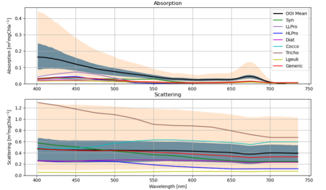
A Three Stream Ocean Optics Model: Regional Implementation and Validation. Adapted by OOI from Miller M., 2022.
[media-caption path="https://oceanobservatories.org/wp-content/uploads/2023/07/EA-science-highlight.png" link="#"](Figure 3.10 from Miller (2022) Top: The black line shows the mean OOI absorption as a function of wavelength for OOI Endurance CSPP Oregon shelf deployment 15 (August – Sept 2019). The gray shading shows the OOI absorption extent between the 20% and 80 % quantiles. The tan shading shows the maximum and minimum extent of OOI absorption. The colored lines correspond to the modeled absorption for different single species approximations. Bottom: Same as top, but for scattering instead of absorption.[/media-caption]Miles Miller used OOI data as part of this MS thesis awarded September 2022 from the Univ. California, Santa Cruz. The goal of his work was to develop the potential to estimate phytoplankton community structure from remotely sensed optical information and not direct in situ phytoplankton observations. As a step towards this goal, he estimated phytoplankton community structure using spectrally dependent optical absorption and scattering data from an AC-S on the Oregon Shelf profiler. Miller developed linear relationships between modeled phytoplankton absorption and scattering and corresponding observations and solved them by constrained least squares inversion over a field of thirteen wavelengths using six phytoplankton types. He solved the problem for independent absorption and scattering as well as coupled absorption and scattering. He estimated phytoplankton communities as a function of profile depth and for multiple profiles in time.
The model produced accurate downward irradiance fields when using observed absorption and scattering profiles obtained from the Ocean Observatories Initiative’s Oregon Shelf Surface Piercing Profiler Mooring. Through this forward modeling-based comparison to observations it was found that the optical model can produce accurate profiles under certain conditions, making it promising for data assimilation of remote sensing reflectance as a function of wavelength. Miller identified several outstanding issues remaining to be addressed to move from using in situ measured absorption and scattering to estimates from remote sensing reflectance. Because the optical model accuracy is primarily dependent on absorption and scattering, he argued that remote sensing reflectance accuracy can be improved with enhanced phytoplankton community structure and CDOM estimations (see Figure 3.10 from Miller (2022). This figure shows that the modeled phytoplankton light attenuation agrees well with the measurements but that modeled absorption underestimates measurements. This underestimation hints that chromophoric dissolved organic matter (CDOM) is not being properly resolved as CDOM affects only total absorption and not scattering.
_________________________________________
Miller, M. (2022). A Three Stream Ocean Optics Model: Regional Implementation and Validation (master’s thesis). University of California, Santa Cruz. 62 pp.
Read MoreNew Features of Data Explorer Demo
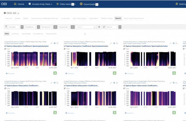
In case you missed it, here is a video of the OOI Town Hall on July 26, 2023 during which the new features of Data Explorer were demonstrated and questions answered.
[embed]https://vimeo.com/849129117[/embed] Read MoreOOIFB Bio-Optics Sensor Summer School Happening Now
The OOIFB is hosting a 2023 summer school this week (July 17-21, 2023) at Oregon State University (OSU) in Corvallis focusing on OOI optical attenuation and absorption data. A mix of advanced graduate students, post-doctoral fellows, and early career scientists have traveled to Oregon to participate in a hands-on learning experience about how to access, analyze, and interpret data from the Sea-Bird AC-S. Data from the AC-S is used to characterize the absorption and scattering of light in seawater, which provides information on phytoplankton biomass in the measured ocean region.
The workshop’s daily agenda is jam packed. OSU Associate Professor and AC-S expert Andrew Barnard is leading the lecture portion of the workshop to ensure participants have a clear understanding of what the AC-S measures, how the instrument works, and how to interpret the collected data. Coastal Endurance Principal Investigator Ed Dever, who was instrumental in organizing the workshop, will also present an introduction to AC-S and related OOI measurements.
Each day participants are assigned data-related homework, so they can learn data analysis skills with the help of OOI data experts. OOI data experts Chris Wingard of the Coastal Endurance team and Wendi Ruef of the Regional Cabled Array are on hand all week to help participants work with the data. Data expert Jennifer Batryn of the Coastal and Global Scale Nodes Team will be lending a hand virtually.
OOI uses the Sea-Bird AC-S as its spectrophotometer, referring to it as “OPTAA: optical attenuation and absorbance instrument.” The optical attenuation and absorption data provides information on the relative biomass of different phytoplankton size classes and phytoplankton functional types, estimates of biogeochemical proxies, and may be used to validate remote sensing measurements. AC-S sensors are deployed on most of the OOI platforms, including coastal, cabled, and high latitude moorings and are a significant proportion of the overall sensors deployed.
Kendra Daly, OOIFB chair, who proposed the idea and helped execute the workshop said, “We thought what a great opportunity to gather OOI data experts, put them in the same room for a week with those wanting to use these data in their research, and watch the synergy happen! The experience is sure to have a multiplier effect. OOI data experts will benefit from the data users’ experience, while the data users will end up being OOI data experts themselves.”
To maximize the usefulness of the workshop, the workshop curriculum was made available online.
Read More
Call for Applications for OOIFB
~ Call for Applications ~
OOI Facility Board
Application Deadline: August 6, 2023
The Ocean Observatories Initiative Facility Board (OOIFB) provides independent input and guidance regarding the management and operation of the National Science Foundation-funded Ocean Observatories Initiative (OOI). The OOIFB works to expand scientific and public awareness of OOI, and ensure that the oceanographic community is kept informed of developments of OOI.
The responsibilities of the OOIFB may include, but are not limited to, the following:
- Serving as the prime scientific and technical conduit between the oceanographic community and NSF regarding OOI.
- Examining the accomplishments and work flow of the OOI Operator, in order to provide feedback regarding the OOI Annual Work Plans (AWPs)
- Via workshops, community meetings, and/or other mechanisms, stimulate and engage the user community in order to keep the accomplishments of the OOI at the cutting edge of scientific inquiry and technological innovation.
- Developing and implementing strategies to expand scientific and public awareness of the unique scientific and technological opportunities of the OOI.
- Helping to identify collaborative relationships with potential governmental, industrial, educational, and international partners in the OOI, where appropriate.
- Ensure fair and consistent access to the OOI by all sectors of the user community.
Applications should be submitted to Annette DeSilva at the OOIFB Administrative Support Office, and must include a letter of interest and a CV. The statement of interest should highlight the applicant’s experience using observatory data, as well as how the applicant has supported the introduction and/or inclusion of ocean sciences to underrepresented communities and have fostered an environment of respect in their research endeavors. Applicants who have not yet had the opportunity for such experience should note how their work will further OOIFB’s commitment to diversity.
Please note, applications cannot be accepted from individuals affiliated with the OOI Program Facility institutions (Woods Hole Oceanographic Institution, Oregon State University, and the University of Washington), individuals under contract with the OOI Program, and individuals from institutions already represented on the OOIFB (the current list of OOIFB members is available HERE).
Applications are due by August 6, 2023. Applications will be reviewed by the OOIFB, who will give due consideration to the qualifications of applicants, as well as the maintenance of gender, career level, discipline, and regional balance on the OOIFB. For more information about OOIFB and its activities, please visit the website or contact Kendra Daly, OOIFB Chair.