
News
NSF Funds Creation of Offshore Subduction Zone Observatory as part of OOI’s Regional Cabled Array
With support from the US National Science Foundation, the Ocean Observatories Initiative’s (OOI) Regional Cabled Array (RCA) will be expanded to include an Offshore Subduction Zone Observatory on the Cascadia margin. This new addition to the RCA will produce real-time data to help answer fundamental questions about how subduction zone faults work and can enhance existing systems for earthquake and tsunami warning.
The University of Washington (UW) will lead a team that includes Scripps Institution of Oceanography to implement the “Creating an Offshore Subduction Zone Observatory in Cascadia with the Ocean Observatories Initiative Regional Cabled Array” (COSZO) project to add geohazard sensing instruments, including seismic sensors and calibrated seafloor pressure gauges, to the existing NSF-funded Regional Cabled Array. The UW received one of four Mid-Scale Research Infrastructure-1 (Mid-scale RI-1) awards announced by the US National Science Foundation for Fiscal Year 2023-2024.
“The four awardees NSF has selected — the University of Rochester, Iowa State University, the University of Washington, and the University of Southern California — exemplify the most novel, innovative infrastructure being designed and built in our country to advance the best ideas and train the highly skilled talent in science and engineering for our future,” said NSF Director Sethuraman Panchanathan. “By investing in the most innovative infrastructure, NSF aims to strengthen opportunities for all Americans and advance the frontiers of science and technology.”
Earth’s greatest geological hazards are concentrated in subduction zones. These places where two tectonic plates converge and collide not only produce large-scale earthquakes but suffer from their cascading effects such as devastating tsunamis. The Cascadia subduction zone, spanning the offshore coasts from northern California to British Columbia, hosts earthquakes up to magnitude 9 every few hundred years, the last of which was in 1700. The RCA currently brings power and internet into the ocean offshore of Newport, Oregon.
Today seismic and geodetic sensor networks on land in the Pacific Northwest can quickly alert authorities to geohazards, but the offshore region, where almost all the locked plate boundary and expected earthquake slip would occur, is largely devoid of such instruments.
“There’s a huge amount of interest in subduction zones, from Sumatra to Chile,” said oceanographer William Wilcock, one of several investigators on this project. “Because of the risks and hazards of subduction zones, the National Science Foundation and others have invested in studies to understand a wide variety of subduction zones because they all behave a bit differently and can have devastating impacts.”
“This award will make it possible for scientists to have a front-row seat of the subduction zone with real-time data from 2900 to 80 meters below the ocean’s surface” said Deborah Kelley, Principal Investigator of the Regional Cabled Array. “It builds upon some of the ideas that motivated the OOI. It clearly demonstrates the opportunities for growth through the RCA’s ability to provide power and unprecedented bandwidth to instruments that are monitoring conditions around the clock on the seafloor and throughout the water column. From this will come important new discoveries about how our planet works.”
“We are excited by the addition of COSZO to the Regional Cabled Array,” said Jim Edson, who leads OOI’s Program Office at Woods Hole Oceanographic Institution. “The data made available from COSZO via NSF’s Seismological Facility for the Advancement of Geoscience, will help scientists and engineers understand the hazards from earthquakes and tsunamis, with the potential for improvement of early warning systems, which can ultimately help save human lives. “
A story about the COSZO project can be found here.
——————————————
The Ocean Observatories Initiative is a science-driven ocean observing network that delivers real-time data from more than 900 instruments to address critical science questions regarding the world’s oceans. The National Science Foundation has funded the OOI, under Cooperative Agreement No. 1743430, to encourage scientific investigation. OOI data are freely available online to anyone with an Internet connection.
The U.S. National Science Foundation is an independent federal agency that supports science and engineering in all 50 states and U.S. territories.
Any opinions, findings, and conclusions or recommendations expressed in this material are those of the author(s) and do not necessarily reflect the views of the National Science Foundation.
October 19, 2023
Read More
Wave Statistics from 3-Axis Motion Sensors on OOI Surface Buoys
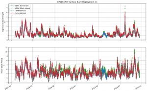
The Ocean Observatories Initiative (OOI) Pioneer Array at the New England Shelf (Pioneer-NES) collected data for nine years from November 2013 through November 2022 across the shelf break. Of the three Surface Moorings in the array (Inshore – ISSM (40.37°N, 70.88°W); Central – CNSM (40.14°N, 70.77°W); Offshore – OSSM (39.94°N, 70.89°W), only CNSM was equipped with a surface wave sensor: the Axys Technologies Tri-Axys Directional Wave Sensor (WAVSS). This meant that observations on wave data were limited to a single location within the array. Recognizing that data from a single location could be restrictive for some types of analysis, the Coastal and Global Scale Nodes Group (CGSN) identified an opportunity to increase the number of surface wave observations and extend their geographic extent to the full cross-shelf span of the Pioneer-NES Moored Array. This was accomplished by using the engineering data collected by the MicroStrain 3-axis motion sensors (MOPAK) deployed on all three surface moorings. The data collected by the MOPAKs can be used to compute the bulk and directional wave statistics at each Surface Mooring in the array.
The MOPAK sensors collected triaxial acceleration, angular rate, and magnetic orientation for 20-minutes at 10 Hz once-an-hour. These data are used to compute the buoy displacements and velocities. A zero-crossing algorithm, which identifies the number of times the buoy vertical displacement (heave) crosses zero (indicative of wave motion), is used to calculate six bulk wave statistics: significant wave height (Hsig) and period (Tsig); wave height (H10) and period (T10) of the highest 10% of waves; and the mean wave height (Havg) and period (Tavg).
The wave power and cross-spectrums are used to compute five directional wave statistics: peak wave height (Hs) and period (Tp); mean wave direction and spread; and an alternative method for significant wave height (Hm0). The MOPAK-derived wave statistics were validated against, and showed excellent agreement with, both the WAVSS dataset from the CNSM mooring and wave datasets collected by National Data Buoy Center wave buoys 44097 (Block Island, RI – 40.97°N, 71.12°W) and 44008 (Nantucket, MA – 40.50°N, 69.25°W).
[media-caption path="https://oceanobservatories.org/wp-content/uploads/2023/10/Screenshot-2023-10-31-at-3.12.55-PM.png" link="#"]Figure 1. The significant wave height (Top) and mean wave period (Bottom) at the Pioneer-NES Central Surface Mooring for Deployment 11 (Apr. 2019 – Sept. 2019) as measured by the WAVSS (blue), calculated from the MOPAK (red), and from the two nearest located NDBC buoys – Nantucket (green) and Block Island (grey).[/media-caption]The Python code to process a MOPAK dataset into a wave dataset is available to users as the process_mopak.py module in the public OOI Data Exploration GitHub repository. The wrapper function calculate_wave_statistics in the module accepts a deployment’s worth of MOPAK data and returns a new dataset with the calculated wave statistics, including attributes, units, and associated metadata, which may be saved as a new netCDF file. This process triples the number of surface wave datasets at the Pioneer-NES Array, allows for validation of the existing WAVSS wave dataset, and opens new possibilities for studying the wind-wave field across the NES-break.
We encourage users to work with the MOPAK code to generate surface wave statistics, and to submit any questions to the OOI HelpDesk.
Read More
NSF Issues Notice of Draft Supplemental Site-Specific Environmental Assessment for Pioneer Relocation
The NATIONAL SCIENCE FOUNDATION posted the following announcement today, September 29, 2023:
MEMORANDUM FOR: TRIBES, GOVERNMENT AGENCIES, ORGANIZATIONS, INDIVIDUALS, AND INTERESTED PARTIES
FROM: NATIONAL SCIENCE FOUNDATION (NSF)
RE: Notice of Availability of a Draft Supplemental Site-Specific Environmental Assessment for the NSF Ocean Observatory Initiative (OOI) Pioneer Array Modifications and Relocation to the Mid-Atlantic Bight
The National Science Foundation (NSF) gives notice of the availability of the “Draft Supplemental Site-Specific Environmental Assessment for Pioneer Array Modifications and Relocation to the Mid-Atlantic Bight” (Draft SSSEA) for review and public comment.
NSF proposes to fund the relocation, operation, and maintenance of the NSF Ocean Observatory Initiative’s (OOI) Pioneer Array to the Mid-Atlantic Bight (MAB) off North Carolina in the Northwest Atlantic Ocean (Proposed Action). The OOI is a globally distributed, networked, ocean-focused research observatory with arrays of sophisticated instruments that utilize cutting-edge technologies to observe and study ocean processes. The Pioneer MAB Array would represent a Coastal Scale Node component of the OOI. The Pioneer MAB Array is designed to resolve transport processes and ecosystem dynamics in the vicinity of the shelf-break front, a region of high biological productivity and complex oceanographic dynamics that include intense mesoscale variability and episodic event disturbances (i.e., hurricanes). It would collect high-resolution, multidisciplinary, synoptic measurements spanning the shelf break on horizontal scales from a few kilometers to several hundred kilometers. The array is designed and planned to be relocatable approximately (~) every 5 years with new locations proposed by the NSF with input from the scientific community.
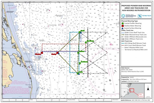
The Proposed Action would (1) relocate the Pioneer New England Shelf (Pioneer NES) Array to the southern MAB (Pioneer MAB Array, Figure 1); 2) modify the mooring designs for the new site water depths; and 3) include additional scientific instrumentation on the moorings. The Proposed Action would occur within the Exclusive Economic Zone (EEZ) of the U.S. but outside of state waters. The Pioneer MAB Array would be a T-shape array located off the coast of Nags Head, North Carolina, starting ~24 kilometers (km) (~13 nautical miles [nm]) offshore, extending ~59 km (~32 nm) east/west and ~49 km (~26 nm) north/south across the continental shelf, centered at the shelf-break front. The Project Area, including the surrounding area of potential effect, would consist of 10 moorings and a 2 km by 2 km (1 nm by 1 nm) square around the center point of each of the mooring locations. In addition, there would be mobile assets, such as autonomous underwater vehicles (AUVs) and gliders that would operate around the moorings. Gliders and AUVs would run underwater missions along tracks in the vicinity of the moored array. Two (2) AUVs and four (4) gliders would be used to provide underwater monitoring abilities along and across the shelf and within the waters of the continental slope. Gliders would be deployed on a 60-90-day rotation schedule and would be operated continuously along pre-determined paths, while the AUVs would be deployed for limited periods of ~4 days every 2 months.
[media-caption path="https://oceanobservatories.org/wp-content/uploads/2023/09/SSSEA-Figure-1-revised38-scaled.jpg" link="#"]Figure 1. Proposed Pioneer MAB Array of Moorings and Surface Projection of Underwater Track lines for Mobile Assets[/media-caption]The Pioneer MAB Array is proposed to be deployed in April 2024. The array and associated AUVs and gliders would be serviced primarily by vessels from the U.S. Academic Research Fleet (ARF) with support from local chartered vessels when needed; a proposed schedule for installation, operations, and maintenance is included in the Draft SSSEA. Installation, operations, and maintenance activities would use standard methods and procedures currently used by the ocean observing community. Like on the Pioneer NES Array, the moorings deployed at Pioneer MAB would include anchors and benthic nodes designed to be fully recoverable, minimizing impact on the seabed.
The Draft SSSEA evaluated the potential impacts of the Proposed Action on the human and natural environment, pursuant to the National Environmental Policy Act (NEPA) and tiers to existing OOI NEPA documentation1. The Draft SSSEA focused on activities and associated potential impacts on marine resources (e.g., geological, marine biological, socioeconomic, etc.) that were not previously assessed by existing OOI NEPA analyses. The conclusions from the Draft SSSEA were used to inform the NSF Division of Ocean Sciences (OCE) of potential environmental impacts of the Proposed Action.
1OOI NEPA documents are available on the NSF website.
Impacts from the placement of proposed mooring anchors or nodes on the seafloor would include temporary disturbance of soft sediments and coverage of relatively small areas of substrate by the anchors and scientific sensors (~37 m2) for the deployment period. Over time, the natural movement of sediments by ocean currents and burrowing organisms would reestablish natural bottom topography. Upon conclusion of operations, the entire system, including anchors and nodes, would be removed from the MAB Project Area. A small amount of Essential Fish Habitat (EFH) may potentially be impacted during installation activities. The short-term and minor increases in turbidity and sedimentation resulting from system installation, operations, maintenance, and removal would not affect the ability of EFH to support healthy fish populations, and affected areas are expected to recover quickly. The vessels and activity associated with installation and maintenance of the moorings may cause marine species, such as Endangered Species Act (ESA)-listed marine mammals, to avoid the immediate vicinity of the proposed Pioneer MAB Array sites, but this impact would be brief and temporary due to the nature of the proposed activities (estimated time to deploy a mooring with one vessel is 12 to 24 hours). Entanglement and vessel strike/collision threats to marine mammals or sea turtles are not anticipated due to the equipment design, slow operational speed (0.5 to 2 knots), and use of NMFS standard oceanographic marine mammal vessel strike avoidance measures, including special measures for North Atlantic Right Whale. The use of gliders and AUVs is not expected to affect marine species, as the proposed gliders and AUVs are self-contained and move slowly within the water column similar to a dolphin or whale. Additional new scientific instrumentation sensors would be mounted on or incorporated into the existing mooring designs; however no adverse effects to marine species are anticipated from the new sensors. Mooring sites were selected to avoid historic and cultural resources (e.g., shipwrecks).
Specific sensitive areas were considered during early planning and siting of the Pioneer MAB Array. The array would not overlap with or be anticipated to impact artificial reefs or fishery nursery areas. Four of the Pioneer MAB Array moorings would be located within the loggerhead sea turtle Constricted Migratory Corridor; however, they are not anticipated to impede sea turtle migration. The Pioneer MAB Array would not overlap with loggerhead sea turtle Coastal Critical Habitat Designation (sargassum habitat). The Pioneer MAB Array’s southernmost mooring would be located within a joint Snapper-grouper/Coral Reefs and Hardbottom/Dolphin and Wahoo Habit Areas of Particular Concern (HAPC) designated by the South Atlantic Fisheries Management Council (SAFMC). The small scale and temporary nature of the single mooring would have little to no impact on the HAPC. A survey conducted of the sites also did not indicate the existence of corals.
Due to the distance from shore, small footprint, localized and temporary nature (~5 years), interactions between the Proposed Action and other ocean users, including fishing operations, in the study area are expected to be limited. Other activities, including fisheries, could occur within the proposed project area; a safe distance, however, would need to be kept from Pioneer MAB Array individual moorings. Any potential space-use conflicts would be minimized through outreach and communication with ocean users. The USCG would be contacted prior to the deployment of moorings as part of the Private Aids To Navigation (PATON) approval process and the Pioneer MAB Array moorings would be easily visible and avoidable. All mooring locations and associated components of the Pioneer Array would be published in NOAA charts, Notice to Mariners and Local Notice to Mariners. Gliders and AUVs would be marked with the name of the owning organization and a contact telephone number that ocean users could call to report any encounters at sea.
The Draft SSSEA also assessed potential cumulative effects of the Proposed Action. Overall, the combination of the proposed activities with other activities occurring in the region is expected to produce only a negligible increase in overall disturbance effects on the marine environment. Given the distance from shore, small footprint, temporary nature, and experience with Pioneer NES, significant impacts from the Proposed Action are not anticipated on the marine environment. While the Proposed Action may affect EFH and ESA-listed species, adverse effects are not likely. NSF will consult with federal regulatory agencies as applicable and appropriate.
Additional information about the proposed Pioneer MAB Array can be found in the Draft SSSEA and tiered OOI NEPA documentation, including details on relocation, operations, and maintenance; scientific instrumentation; potential effects, and diagrams of the array components.
After reviewing and considering all public comments received during the public comment period and regulatory processes, NSF will issue a Final Supplemental Site-Specific Environmental Assessment (Final SSSEA), accompanied by a decision document.
Public Comments:
The Draft SSSEA regarding the proposed action is posted for public comment on the NSF website closing on October 28, 2023. We welcome any comments you may have on the Draft SSSEA. Comments may be submitted via email to: nsfnepaooipioneer@nsf.gov. Comments received will be addressed in the Final SSSEA.
Read MoreFour-Part Series on Using Data Explorer
OOI Data Specialist Stace Beaulieu has put together a four part-series demonstrating how to use Data Explorer. In eight minutes or less per session, you can learn how to find and visualize time-series, glider, or profiler data and compare time-series data. The demos can be accessed below, on YouTube, and permanently under Tutorials on this website. Be sure to bookmark the site for future reference. A print version of the four-part series can be accessed and downloaded here.
[embed]https://youtu.be/9CA5GsGL2-0[/embed] [embed]https://youtu.be/SEwHMSyQFUg[/embed] [embed]https://youtu.be/smrSszcO4RY[/embed] [embed]https://youtu.be/ql8JvTGyrmI[/embed] Read MoreNational Science Foundation Renews OOI for Another Five Years
The National Science Foundation (NSF) announced that it has awarded a coalition of academic and oceanographic research organizations a second, five-year contract to operate and maintain the Ocean Observatories Initiative (OOI). The coalition, led by the Woods Hole Oceanographic Institution (WHOI), and including the University of Washington (UW) and Oregon State University (OSU), will continue operations of the OOI, a science-driven ocean observing network that delivers real-time data to address critical science questions regarding the world’s oceans.
WHOI has led the operations and management aspects of the OOI since 2018 and will continue to serve as the home for the next five years of the OOI Project Management Office, led by Principal Investigator James B. Edson and Sr. Program Manager Paul Matthias.
The OOI collects and serves measurements from more than 900 autonomous instruments on the seafloor and on moored and free-swimming platforms that are serviced during regular, ship-based expeditions to the array sites. Data from each instrument are transmitted to shore and are freely available to users worldwide, including scientists, policy experts, decision-makers, educators, and the public.
Under this new $220 M investment, each institution will continue to operate and maintain the portion of OOI assets for which it is currently responsible: WHOI will operate the Pioneer Array in the mid-Atlantic Bight off the North Carolina coast, subject to environmental permitting, and the Global Arrays in the Irminger Sea off the southern tip of Greenland and at Station Papa in the Gulf of Alaska; UW will operate the Regional Cabled Array that extends across the Juan de Fuca tectonic plate and through the overlying ocean; and OSU will operate the Endurance Array off the coast of Washington and Oregon. OSU also houses and operates OOI’s Data Center that ingests and delivers all OOI data.
“OOI has proven to be an exceedingly valuable source of information about the ocean,” said NSF Program Officer for OOI George Voulgaris. “Its freely available data are contributing to better understanding of ocean processes and how the ocean is changing. Scientists are using OOI data as the source of cutting-edge scientific discoveries—everything from getting close to predicting underwater volcanic eruptions to changing ocean circulation patterns that have real life implications for weather and fishing patterns. OOI data also are serving as inspiration for students in the classroom, who are excited about learning about the ocean with access to real-time ocean data. We at NSF are proud of our continued investment in making these data available.”
“WHOI is honored to have been selected to continue the mission of the OOI, which is providing valuable ocean data at a time when it is critically needed,” said Peter de Menocal, President and Director of the Woods Hole Oceanographic Institution. “The continued extreme weather events reinforce the importance of this ocean monitoring program to provide science-based data that is accessible to researchers, modelers, agencies, and the public, and we look forward to being part of the continued scientific advancements from this transformational program in the years ahead.”
The Project Management Office at WHOI collaborates with NSF to provide high-level oversight and financial management of the project. In addition, the office coordinates with partner institutions to establish annual priorities for each of the arrays individually and for the network. “The WHOI team and our partners at UW and OSU have learned a great deal over the past five years and are grateful that our efforts to perfect OOI and its data delivery system have been recognized,” said WHOI Senior Scientist Jim Edson, lead principal investigator on the OOI. “We look forward to the next five years where we can continue to perfect our collection and serving of data, while encouraging its increased use and collaboration among ocean scientists funded by NSF and other agencies.”
——————————————
About the Ocean Observatories Initiative
The Ocean Observatories Initiative is a science-driven ocean observing network that delivers real-time data from more than 900 instruments to address critical science questions regarding the world’s oceans. The National Science Foundation has funded the OOI, under Cooperative Agreement No. 1743430, to encourage scientific investigation. OOI data are freely available online to anyone with an Internet connection.
The U.S. National Science Foundation is an independent federal agency that supports science and engineering in all 50 states and U.S. territories.
Any opinions, findings, and conclusions or recommendations expressed in this material are those of the author(s) and do not necessarily reflect the views of the National Science Foundation.
Read More
RCA’s Ninth Expedition: Best Laid Plans
Written by Deborah Kelley, PI of the Regional Cabled Array, September 17, 2023
The Regional Cabled Array, spanning the Cascadia Margin and Juan de Fuca tectonic plate and water depths of ~260 ft to 9500 ft, is an engineering marvel. It is the most advanced underwater observatory in the oceans comprised of >900 km of high power- and -bandwidth submarine fiber optic cables, a highly diverse suite of >150 instruments, and state-of-the-art moorings with instrumented profilers, which since 2014 have traversed >50 million meters of ocean water! The underwater substations and instruments are installed in some of the most extreme environments on Earth, including the most active submarine volcano off the Oregon-Washington coast ‘Axial Seamount’. Here, extension cables traverse glass covered lava flows and instruments are inserted into underwater, acidic hot springs, hot enough to rapidly dissolve aluminum and melt lead. Profiling science pods on moorings that traverse ocean depths from ~650 ft to 16 ft nine times a day, must be ‘smart’ enough to keep “their heads down” when storms, common in the waters of the NE Pacific Ocean, create waves reaching 30 feet in height or more. Yet, it is within these environments that the cabled observatory has thrived, largely due to its design, rigorous testing, and the hard work of the RCA Team, and Jason and Thompson crews during the annual operations and maintenance expeditions, such as the one nearing its end now: VISIONS’23.
[media-caption path="https://oceanobservatories.org/wp-content/uploads/2023/09/Katie_Studenst_sm-20230908_200403_startL4_ME-copy-scaled-1.jpg" link="#"]First time RCA Chief Scientist Katie Bigham (top row, second from left) with Co-Chief Scientist J. Nelson (far left), RCA technician Andrew Paley (top row, far right) and Leg 4 VISIONS students. Katie was a VISIONS’14 student. Credit: M. Elend, University Washington, V23.[/media-caption]Planning for the RCA 2023 cruise began over a year ago as there is a high demand for NSF’s global class ships that operate throughout the worlds’ oceans. Scheduling is a complex process with lots of moving parts involving minimization of transit lengths, awareness of optimum weather windows, and researchers’ schedules. As soon as lasts year’s cruise ended, RCA instruments recovered in the Fall of 2022, were sent back to vendors for calibration and refurbishment, parts and cables were ordered, and the RCA teams’ eyes were already looking to this year. By late Spring, most of the refurbishment and integration testing of platforms and instruments was complete, the four Legs were planned out in detail, and the nearly 144 berthing assignments were finished. The careful layout of equipment on the aft deck of the Thompson was of critical importance, with nearly 200,000 lbs of gear on the fantail and the need for deck space free of gear to allow for mooring cables to be recovered and redeployed.
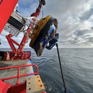
So that brings us to now, nearing the end of Leg 4, which will end on September 18 when the Thompson arrives back to Newport, Oregon. Working at sea is just tough, no way around it, and best laid plans are often adjusted before even leaving port (such as happened at the start of Legs 1 and 3) as the weather gods do not care about our schedule. The prior three Legs experienced numerous perturbations due to the loss of a week of operational days when the ROV Jason could not dive due to bad weather and additional loss of time due to ROV issues. Plans were adjusted on the ‘fly’ over and over again to best accomplish all of our goals, including the recovery and re-installation of >100 instruments. Because of this, some work was pushed out into Leg 4, an already complicated Leg because it was especially dependent on having good sea state conditions due to the planned installation and recovery of two deep profiler moorings, the largest of which rises >8000 ft above the seafloor at the base of Axial Seamount.
[media-caption path="https://oceanobservatories.org/wp-content/uploads/2023/09/Float.jpg" link="#"]The float for the Deep Profiler mooring at the Oregon Offshore site being brought onboard the Thompson. Credit: M. Elend, University of Washington; V23.[/media-caption]Almost immediately, Leg 4 plans were adjusted following the first operation – the recovery and reinstallation of the Deep Profiler Mooring at the Oregon Offshore site. The communications and power ‘dock’ at the base of the mooring would not respond after plugging in the seafloor extension cable that connects it to a small substation (junction box) on the seafloor. While the engineers tested various aspects of the cable, and puzzled over the cause, the RCA team continued their work at the Slope Base site. There, the Deep Profiler mooring cable was cleaned, and the instrumented profiling vehicle deployed in 2022 was replaced. Following this operation, the Thompson transited ~ 18 hrs to the base of Axial Seamount, where, instead of turning the mooring, it was decided to just swap out the vehicle, similar to Slope Base.
[media-caption path="https://oceanobservatories.org/wp-content/uploads/2023/09/getting-ready-to-bring-in-the-cable.sm_.PD01B_20230909_132549_recovery_ME-copy-scaled-1.jpg" link="#"]RCA engineers and ship crew getting ready to spool cable onboard from the Offshore Deep Profiler Mooring. Credit: M. Elend, University of Washington, V23.[/media-caption]With this work complete, a series of dives was planned to support researchers’ projects funded by the National Science Foundation outside of the Ocean Observatories Initiative. These dives were to include sampling of hydrothermal vent fluids to investigate viruses and microbes in these extreme environments, the recovery and installation of cabled CTD instruments to test the hypothesis that highly saline fluids are flushed from beneath the seafloor shortly following an eruption, and the recovery of a cabled multibeam sonar (COVIS) focused on making unique fluid flux measurements in the ASHES hydrothermal field. Time allowing, equipment on the Thompson would be used to “talk” to an acoustic array (FETCH) installed in the volcanoes’ caldera for investigation of deformation within this highly active volcano.
There was, however, a small window to complete this work. After investigation of the Deep Profiler Mooring at the Oregon Offshore site, it was determined that the Thompson would need to transit nearly 300 miles back to this area, to install a new extension cable, and/or recover and redeploy the mooring with the one just recovered at the beginning of Leg 4 – an exercise that could take 2-3 days. Indeed, Jason had other ideas because while working at the summit of Axial, there was an issue with the specialized hydrothermal vent sampler on the vehicle, followed by a failure of the power system, preventing more dives. The Jason team worked very hard overnight to fix the power supply, but with ever decreasing time to get the Deep Profiler work done back on the margin, it was decided to abandon remaining work at Axial (a very tough decision as this would impact researchers work over the entire next year) and head to the Offshore site. This also allowed optimal use of the transit time to thoroughly test the repaired power system for Jason. It also provided time for the APL engineers to ready a new extension cable for the Deep Profiler mooring, hoping that this simple fix would solve the problem, and to catch up on much needed sleep. With huge relief, the replacement of the extension cable did the trick on the first dive at the Offshore site. The docking station powered up and the vehicle completed its test profiling run — opening up a three-day window for additional work.
[media-caption path="https://oceanobservatories.org/wp-content/uploads/2023/09/ratail-sulis_20230916210321_rattail_probe_closeup.jpeg" link="#"]A rattail fish came to investigate the UFO fluid sampler as it obtained fluids for Dr. Rika Anderson at Marker 113, a diffuse flow site in Axial Caldera. Credit: UW/NSF-OOI/WHOI, Dive J2-1559, V23.[/media-caption]With a sigh of relief and desperately wanting to support the external researchers work, Chief Scientist, Katie Bigham, asked Captain Eric to turn the ship around and head back out to Axial Seamount. So away they went, following the same track line they had completed less than 24 hrs before. During the next 34 hrs, Jason pounded out the dives and completed all but the FETCH work, before it was time to once again head back to Slope Base to complete two final tasks.
The above description is only part of what goes on during the various legs of these RCA expeditions. It is hard to convey what it is like to be a Chief Scientist on an RCA cruise. As with this cruise, decisions must be made rapidly, but also strategically, with an eye towards the end of a leg and cruise – “Will this decision prevent other work from happening? What is the weather going to be like in 2-3 days? What is the status of equipment? How are the students doing and how are their projects going? Do they need help? Is the team getting enough sleep? Should we transit to another site to help with this? On and on it goes…Awareness of these questions and outcomes are always in a Chief Scientists’ thoughts and are combined with the everyday tasks of writing plans for the next day and operational reports.
This was Katie’s first time being a Chief Scientist. She has done an exceptional job making adjustments to our “best laid plans” on a cruise that has been one for the books in the near decade of RCA operations and maintenance expeditions.
For more information on the RCA’s ninth operations and maintenance expedition, visit here.
Read More
Biogeochemical Sensor Data Best Practices and User Guide Now Available

The Global Ocean Observing System (GOOS) recently endorsed a finalized guide on how to use data generated by biogeochemical (BGC) sensors deployed by the Ocean Observatories Initiative (OOI).
The OOl Biogeochemical Sensor Data Best Practices and User Guide is intended to provide current and prospective users of data generated by BGC sensors deployed on OOI arrays with the information and guidance needed for them to ensure that the data are science ready. The guide is aimed at researchers with an interest or some experience in ocean biogeochemical processes. The guide was written with the assumption that its users would have some background in oceanography but not necessarily any prior experience working with BGC sensors or data they collect.
The guide was created by a 25-member Working Group, with input from 14 Beta Testers who joined the Working Group members for a June 2022 workshop. The draft version of the guide was revised based on Beta Tester feedback, and then circulated for open review by the full scientific community. The finalized guide, incorporating feedback from the open review process, was then endorsed as a best practice by GOOS after this rigorous review.
“We are delighted that our endeavor to make BCG data more broadly usable and accessible to the oceanographic community has been endorsed by GOOS,” said Hilary Palevsky of Boston College and a co-leader of the working group. “This has been a true team effort to develop best practices that will be broadly useful for the community and has demonstrated the importance of broad collaboration. We look forward to this guide enabling new science bringing in new users of OOI BGC data.”
Download the BGC Sensor Data Best Practices Guide.
Read MoreTenth Refresh of the Irminger Sea Array
On August 27th, a team of 13 scientists and engineers boarded the R/V Neil Armstrong in Reykjavik, Iceland to head to the Irminger Sea Array. Most of the array’s infrastructure and instrumentation was shipped from Woods Hole Oceanographic Institution (WHOI) in mid-July to Iceland, where it arrived in mid-August. Part of the scientific party traveled to Reykjavik in mid-August to reassemble the moorings and conduct a “burn-in,” a test period for the power, data, telemetry, and instrument systems to ensure everything is operational prior to loading the vessel.
The Irminger Sea Array is in a region with high wind and large surface waves in the North Atlantic and is one of the few places on Earth with deep-water formation that feeds the large-scale thermohaline circulation. Data collected by the Irminger Sea Array are providing critical insights into circulation patterns, ocean processes, and possible climate-induced changes occurring in this important oceanic area.
After an ~ two-day transit (550 nautical miles) to the array site off the tip of Greenland, the team will recover and deploy four moorings and three gliders over the next two and a half weeks. They will conduct CTD (conductivity, temperature, and depth) casts at the deployment/recovery sites and carry out shipboard sampling for field validation of the platforms and sensors that will remain in the water for the next year.
In addition to the recovery and deployment operations, the team will be conducting some CTD calibration casts in support of OSNAP-GDWBC (Overturning in the Subpolar North Atlantic Program-Greenland Deep Western Boundary Current). A participant from the National Oceanic and Atmospheric Administration will also be on board using “Big Eye” binoculars mounted on a forward deck to make observations of marine mammals during the transit and in the Irminger Sea.
[media-caption path="https://oceanobservatories.org/wp-content/uploads/2023/08/Big-eyes.jpg" link="#"]Large, deck-mounted binoculars known as “big eyes” are used for marine mammal observations. NOAA Research Wildlife Biologist Peter Duley will be aboard the R/V Neil Armstrong watching for marine life in the Irminger Sea. Credit: Al Plueddemann ©WHOI.[/media-caption]The Irminger Team will also be testing out some equipment modifications on this deployment. One change is an updated satellite telemetry system. This system would provide higher bandwidth allowing better and quicker data transmission from the global surface mooring potentially saving power, and better remote command and control of the mooring systems. Another change is a revised mounting scheme for the glider optode, which measures dissolved oxygen concentrations in the water column. The new mount may provide better in-air measurements during glider surfacing. The in-air measurements allow scientists to characterize the changing accuracy of the instrument over time.
“It’s always a challenge to get ready for this month-long expedition to this remote, but critical region, but we are ready and eager to get there,” said John Lund, Chief Scientist for Irminger 10. “We are pleased to play a part in collecting data that scientists are using to better understand changes occurring in this region, with implications for both weather and climate.”
The team will reporting regular updates from the field. Bookmark this page so you can follow along on their progress.
Read MoreOOI Engineers Develop New Rechargeable Lithium-ion Battery Pack
By John Lund, Research Associate, Woods Hole Oceanographic Institution
The final deployment of the Coastal Pioneer Offshore Mooring (CP04OSPM-00016) was the first deployment of a prototype rechargeable lithium-ion battery pack. The deployment was a success with the battery pack providing power throughout the entire 6.5-month deployment.
Working with Mathews Associates Inc. the OOI engineering team developed a drop-in replacement lithium-ion rechargeable battery pack to replace the original one-time use alkaline packs. Each alkaline pack consists of 72 D-sized batteries that are fabricated into a hexagonal assembly. Nine of these battery packs are fitted into a buoy battery chassis that fits inside the buoy well. The packs are wired together in parallel to provide the required voltage to power the computer (buoy controller) responsible for telemetry and data-logging.
Pioneer moorings are nominally deployed for 6-month intervals. Variability in ship scheduling requires that the buoys be capable of operating for 7+ months. The alkaline battery chassis was designed to fit enough packs to power the buoy for the planned duration and or until the recovery ship arrived.
[media-caption path="https://oceanobservatories.org/wp-content/uploads/2023/08/Lithium-batteries.jpg" link="#"]Lithium Battery chassis during testing and integration with the buoy computer. Battery chassis is on the left. Buoy end cap with Linux computer board on the bench. Wire Following Profiler center on the floor collects the majority of the Profiler Mooring data set.[/media-caption]The Offshore mooring was selected to be a test mooring because it is one of the deeper moorings in the New England Shelf (NES) Pioneer Array and as such logs and transmits more data than a shallower mooring. The larger data sets mean that the buoy up-time, and therefore power usage, is greater than one in shallower water so this would be a tougher test of the lithium-ion packs.
Although there is an increased cost to purchasing the initial set of lithium batteries there are many advantages to the rechargeable batteries. Because the alkaline packs are conservatively sized for the deployment there is often a considerable amount of power remaining in the packs when they are recovered, yet this remaining power is insufficient for another full deployment, and new batteries must be used. The chief benefit of the rechargeable batteries will be to keep the one-time use alkaline packs from going to the landfill (~1 ton per year). There is also a considerable labor savings of not having to deconstruct and reload the chassis frames with replacement batteries. Our calculations indicate that we will break in terms of procurement cost compared to alkaline batteries in approximately six years and that the lithium-ion batteries have enough charge cycles (500) to last the duration of the program. With any luck these may be the last batteries we need to purchase for the Profiler Moorings!
Read More
New Controller Latest in OOI Innovations
Having equipment in the water around the clock for six months at a time provides many challenges for the land-based OOI engineering team charged with keeping the equipment operational so there is a continual flow of data to shore. Maintaining consistent, reliable power for the ocean observing equipment is at the top of this list of challenges.
OOI’s data-collecting instruments attached to the moorings run on batteries charged by renewable wind and solar energy. OOI is in the process of replacing the current solar panels with new panels that are more efficient at generating energy, even when shaded. To supplement this upgrade, the OOI arrays are also being outfitted with a brand-new solar controller to manage the energy going into the batteries. Like with the new solar panels, OOI engineers looked for a controller that was available commercially for easier repair and replacement.
“What was important to us was finding a way to use these new solar panels in the best, most optimal way,” said Woods Hole Oceanographic Institution (WHOI) engineer Marshall Swartz. “We looked for a company that would help us specify and build a customized algorithm for a controller that would optimize the functionality of the panels by taking into account battery temperatures.”
[media-caption path="/wp-content/uploads/2021/12/DSC0486-2.jpeg" link="#"]Buoys get quite the workout when they are in the water for six months and more. Powered by wind, solar, and batteries, OOI has recently improved the way energy from the solar panels is managed with new controllers. Credit: ©WHOI, Darlene Trew Crist. [/media-caption]
Some larger, older controllers can consume up to 3-5% of the energy coming into the device, but the new controller is smaller and more efficient, helping to optimize the amount of energy harvested.
Temperature conditions play a big role in how effectively the energy is managed. Changing battery temperatures require the controller to adjust its charge settings to maintain battery life and capacity. The controllers used on OOI moorings sense battery temperature and automatically adjust to assure best conditions to assure reliable operation.
“It’s really essential for us to maintain the proper charge levels for existing temperature conditions,” said Swartz. The OOI buoys encounter a wide range of temperatures: from subfreezing temperatures up to 40°C (over 100°F) when a buoy is sitting in the parking lot before it is deployed. When the buoys are deployed, water temperatures can vary widely from -1 to 33°C (~30 to 91°F), depending on seasonal conditions.
The new controller automatically regulates the amount of electricity going into the battery under such varying temperature conditions. If the wind turbines are generating more energy than the battery needs, for example, the controllers direct excess power into an external load that dissipates heat and adds resistance to the spinning of the wind turbines, preventing the turbines from spinning too fast, possibly damaging their bearings.
“As parts of the OOI infrastructure need replacing or to be upgraded, this offers us the opportunity to find more efficient, and often times, off-the-shelf, less-expensive replacements that will help us keep the arrays functioning and data flowing,” Swartz said. “It’s a winning combination for all parts of the operation.”
Read More