
News
Abstracts Welcome for OSM Session on California Current and NE Pacific Ocean
Abstracts are being sought for a session on data and modeling of the California Current System and the Northeast Pacific Ocean during the 2024 Ocean Science Meeting in February in New Orleans. Edward P. Dever, Oregon State University, Richard K. Dewey, Ocean Networks Canada, and Kashish Sadhwani, Indian Institute of Technology Bombay organized the session to maximize use of modeling efforts in the region and to foster further collaboration among researchers.
“The Northeast Pacific Ocean offers researchers opportunities to study many regionally important processes that impact productivity, seasonal hypoxia, and ocean acidification,” said Edward P. Dever, of Oregon State University, who is chair of the session. “We hope to bring researchers together to share their insights about this important region and to help facilitate collaboration among those working in different areas of the Northeast Pacific.”
The deadline for abstract submission is September 13, 2023. Submit here. A description of the session follows:
OT019 – Sustained Data and Models in Support of Research in the California Current System and Northeast Pacific Ocean
The Northeast Pacific Ocean as defined by the California Current System, Salish Sea, and Gulf of Alaska, has long been a focus of sustained observing and modeling efforts. Regionally important physical processes include coastal upwelling, river plumes, and responses to interannual variability (e.g., ENSO, the Pacific Decadal Oscillation, marine heatwaves, and other events). These processes impact primary productivity, phyto- and zooplankton community structures, seasonal hypoxia, and ocean acidification. In this session, we seek to share insights and facilitate collaboration between observations and models and among researchers working in different areas of the Northeast Pacific. We invite contributions in any of the following broad topics:
- syntheses of sustained data sets for model initialization
- forcing and validation
- best practices for inter comparison and networking across observations
- modeled and observed interactions between different sub-regions
- estimation of rate processes
- advances in bio-acoustic, biogeochemical, and bio-optical measurements, and
- predictions of physical and ecosystem responses across relevant temporal and spatial scales.
Read More
RCA Embarks on a 41-day Operations and Maintenance Expedition
Watch live video here.
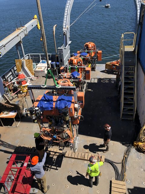
The numbers are remarkable for the Regional Cabled Array’s (RCA) Operations and Maintenance Expedition that left Newport, Oregon aboard the R/V Thomas G. Thompson on Sunday August 13. Because of its complexity and the need to move 100 different instruments, the expedition consists of four legs over 41-days. The legs are separated by ~2-3 days port call at NOAA Marine Operation Center in Newport, Oregon. A science team of 12 is conducting the scientific operations, with their work supported by an engineering team of 20 (not all onboard). The Remotely Operated Vehicle (ROV) Jason, operated by a team of 12 from the Woods Hole Oceanographic Institution, is recovering and deploying instrumentation on the RCA for the duration of the expedition.
Finally, 25 students in the University of Washington’s VISIONS Program are onboard during various legs to gain real sea-going experience and work side by side with the scientific team. Additionally, six other guest participants will be onboard, including a children’s author, engineers, and scientists.
The RCA annual expedition is always an exciting opportunity to watch real-life operations at sea. Operations will be live-streamed here. Details about the expedition, who’s involved, and what’s happening and planned can be found here. Daily updates can be found here.
[video width="608" height="1080" mp4="https://oceanobservatories.org/wp-content/uploads/2023/08/Thompson-loading.mp4"][/video] Read MoreSensor Summer School Curriculum and Video Available
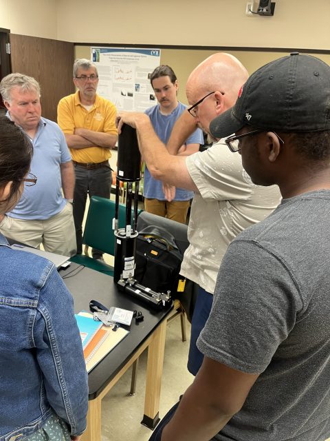
The Ocean Observatories Initiative Facility Board (OOIFB) hosted a 2023 summer school (July 17-21, 2023) at Oregon State University in Corvallis, Oregon that focused on OOI optical attenuation and absorption data. A mix of advanced graduate students, post-doctoral fellows, and early career scientists participated in this hands-on learning experience about how to access, analyze, and interpret data from the Sea-Bird AC-S. Data from the AC-S is used to characterize the absorption and scattering of light in seawater, which provides information on phytoplankton biomass in the measured ocean region.
So others may benefit from what was learned, the curriculum is available online here.
Read More
Spreading Curiosity about Ocean Science with Summer Visitors
Summertime brings students from all over the country to Woods Hole, Massachusetts to learn about ocean science. June and July 2023 were particularly busy, with the Coastal and Global Scale Nodes (CGSN) division of the Ocean Observatories Initiative (OOI) at Woods Hole Oceanographic Institution (WHOI) hosting four different student groups. CGSN offers student tours of OOI facilities and the chance to talk directly with an ocean scientist or engineer. They engage with students this way in the hope of increasing student interest in marine science and possibly encouraging them to pursue an ocean-related career. During the tours and presentations, students learn about the moorings and vehicles OOI deploys throughout the year and the dissemination of ocean data collected. These hands-on experiences give student visitors the opportunity to see the full scale and complexity of OOI operations.
UMass-Dartmouth REU Students Visit
On June 26, 12 community college engineering student and faculty from a National Science Foundation (NSF) sponsored Research Experience for Undergraduate (REU) at the University of Massachusetts, Dartmouth (UMass-Dartmouth) visited OOI. CGSN staff provided a tour of their operations, including ocean-observing equipment stored outdoors because of its size.
[media-caption path="https://oceanobservatories.org/wp-content/uploads/2023/07/Sheri-with-REUs.jpg" link="#"]CGSN team members, Dr. Sheri White (blue jeans to right) and Irene Duran (next to Dr. White) gave a tour to UMass-Dartmouth REU students. Photo by: Kama Theiler © WHOI.[/media-caption] [media-caption path="https://oceanobservatories.org/wp-content/uploads/2023/07/Colin-Dobson-with-REU.jpg" link="#"]A UMass-Dartmouth REU student asks CGSN glider expert Colin Dobson a question regarding the gliders he works on. Photo by: Kama Theiler © WHOI.[/media-caption]PEP Students Visit
In early July, the CGSN team gave a presentation to Woods Hole Partnership Education Program (PEP) participants, who spend 10-weeks in Woods Hole at WHOI, the Marine Biological Laboratory, Woodwell Climate Research Center, National Oceanic and Atmospheric Administration’s Northeast Fisheries Science Center, Sea Education Association, or the United States Geological Survey’s Woods Hole Coastal and Marine Science Center. The PEP program is designed primarily for college juniors and seniors from underrepresented groups in marine and ocean sciences who want to spend a summer gaining practical experience in marine and environmental science.
Summer 2023 is the 15th summer of the PEP program in Woods Hole. Many former PEP students have returned to Woods Hole and WHOI both as students and professionals (including CGSN’s Irene Duran). Benjamin Harden, PEP professor, stated that OOI’s community outreach is a “great way for these students to hear about the frontiers of oceanography and really helped many of them frame possible careers in the field.”
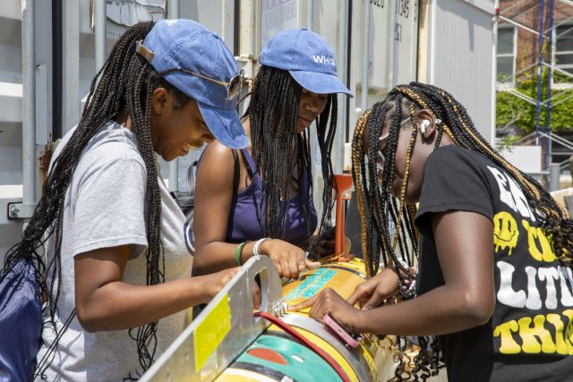
Black Girls Dive Foundation Visit
July 25th, CGSN’s Electrical Team provided a workshop to the Black Girls Dive Foundation (BGDF) program participants. BGDF provides the space and opportunity to empower young black women to explore their STEM (Science, Technology, Engineering and Mathematics) identity through marine science and conservation, and SCUBA diving. While visiting OOI, the BGDF students learned about pH and concerns about increasing ocean acidification. The students collected local sea water and with the help of the CGSN Instrument Team determined its pH with a probe they calibrated using a microcontroller.
[media-caption path="https://oceanobservatories.org/wp-content/uploads/2023/07/BGDF-with-AUV.jpg" link="#"]During their visit to WHOI, BGDF students had the opportunity to get up close to check out an Autonomous Underwater Vehicle (AUV). Photo by: Jayne Doucette © WHOI.[/media-caption] [media-caption path="https://oceanobservatories.org/wp-content/uploads/2023/07/Jennifer-with-BGDF.jpg" link="#"]CGSN Instrument Lead Jennifer Batryn (far left) shows how she checks OOI instruments operations on her laptop to one of the BGDF visitors. Photo by: Jayne Doucette © WHOI.[/media-caption]SEA Participants Visit
Also in late July a group of students participating in the Sea Education Association’s (SEA’s) High School program visited OOI’s Facility LOSOS on WHOI’s Quissett Campus. This is a study abroad program in Woods Hole for undergraduate, gap year, and high school students, that combines studies in ocean science with at-sea experiences. The students spent an afternoon learning about OOI, its operations, how data are collected and disbursed, and what scientists are learning from OOI data.
[media-caption path="https://oceanobservatories.org/wp-content/uploads/2023/07/Dee-and-Jon-With-SEA-students-2.jpg" link="#"]CGSN team members Dee Emrich (standing left) and John Lund explained OOI operations to high school students from the Sea Education Program. Photo by: Dr. Sheri White © WHOI.[/media-caption] [media-caption path="https://oceanobservatories.org/wp-content/uploads/2023/07/Irene-with-SEA-students.jpg" link="#"]CGSN Engineer Irene Duran (maroon top in center) showed mooring components to high school students from the Sea Education Program. Photo by: Paul Whelan © WHOI.[/media-caption] Read MoreNew Features of Data Explorer Demo
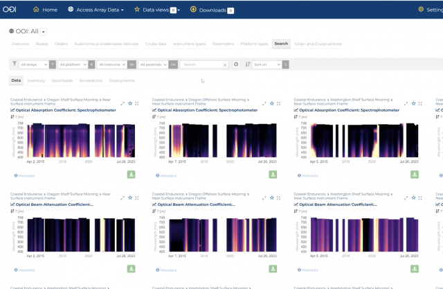
In case you missed it, here is a video of the OOI Town Hall on July 26, 2023 during which the new features of Data Explorer were demonstrated and questions answered.
[embed]https://vimeo.com/849129117[/embed] Read MoreOOIFB Bio-Optics Sensor Summer School Happening Now
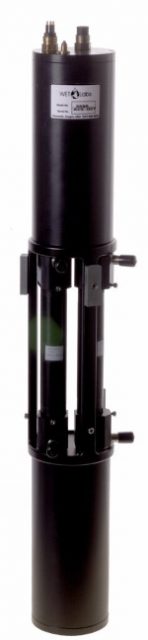
The OOIFB is hosting a 2023 summer school this week (July 17-21, 2023) at Oregon State University (OSU) in Corvallis focusing on OOI optical attenuation and absorption data. A mix of advanced graduate students, post-doctoral fellows, and early career scientists have traveled to Oregon to participate in a hands-on learning experience about how to access, analyze, and interpret data from the Sea-Bird AC-S. Data from the AC-S is used to characterize the absorption and scattering of light in seawater, which provides information on phytoplankton biomass in the measured ocean region.
The workshop’s daily agenda is jam packed. OSU Associate Professor and AC-S expert Andrew Barnard is leading the lecture portion of the workshop to ensure participants have a clear understanding of what the AC-S measures, how the instrument works, and how to interpret the collected data. Coastal Endurance Principal Investigator Ed Dever, who was instrumental in organizing the workshop, will also present an introduction to AC-S and related OOI measurements.
Each day participants are assigned data-related homework, so they can learn data analysis skills with the help of OOI data experts. OOI data experts Chris Wingard of the Coastal Endurance team and Wendi Ruef of the Regional Cabled Array are on hand all week to help participants work with the data. Data expert Jennifer Batryn of the Coastal and Global Scale Nodes Team will be lending a hand virtually.
OOI uses the Sea-Bird AC-S as its spectrophotometer, referring to it as “OPTAA: optical attenuation and absorbance instrument.” The optical attenuation and absorption data provides information on the relative biomass of different phytoplankton size classes and phytoplankton functional types, estimates of biogeochemical proxies, and may be used to validate remote sensing measurements. AC-S sensors are deployed on most of the OOI platforms, including coastal, cabled, and high latitude moorings and are a significant proportion of the overall sensors deployed.
Kendra Daly, OOIFB chair, who proposed the idea and helped execute the workshop said, “We thought what a great opportunity to gather OOI data experts, put them in the same room for a week with those wanting to use these data in their research, and watch the synergy happen! The experience is sure to have a multiplier effect. OOI data experts will benefit from the data users’ experience, while the data users will end up being OOI data experts themselves.”
To maximize the usefulness of the workshop, the workshop curriculum was made available online.
Read More
Call for Applications for OOIFB
~ Call for Applications ~
OOI Facility Board
Application Deadline: August 6, 2023
The Ocean Observatories Initiative Facility Board (OOIFB) provides independent input and guidance regarding the management and operation of the National Science Foundation-funded Ocean Observatories Initiative (OOI). The OOIFB works to expand scientific and public awareness of OOI, and ensure that the oceanographic community is kept informed of developments of OOI.
The responsibilities of the OOIFB may include, but are not limited to, the following:
- Serving as the prime scientific and technical conduit between the oceanographic community and NSF regarding OOI.
- Examining the accomplishments and work flow of the OOI Operator, in order to provide feedback regarding the OOI Annual Work Plans (AWPs)
- Via workshops, community meetings, and/or other mechanisms, stimulate and engage the user community in order to keep the accomplishments of the OOI at the cutting edge of scientific inquiry and technological innovation.
- Developing and implementing strategies to expand scientific and public awareness of the unique scientific and technological opportunities of the OOI.
- Helping to identify collaborative relationships with potential governmental, industrial, educational, and international partners in the OOI, where appropriate.
- Ensure fair and consistent access to the OOI by all sectors of the user community.
Applications should be submitted to Annette DeSilva at the OOIFB Administrative Support Office, and must include a letter of interest and a CV. The statement of interest should highlight the applicant’s experience using observatory data and have fostered an environment of respect in their research endeavors.
Please note, applications cannot be accepted from individuals affiliated with the OOI Program Facility institutions (Woods Hole Oceanographic Institution, Oregon State University, and the University of Washington), individuals under contract with the OOI Program, and individuals from institutions already represented on the OOIFB (the current list of OOIFB members is available HERE).
Applications are due by August 6, 2023. Applications will be reviewed by the OOIFB, who will give due consideration to the qualifications of applicants, as well as the maintenance of gender, career level, discipline, and regional balance on the OOIFB. For more information about OOIFB and its activities, please visit the website or contact Kendra Daly, OOIFB Chair.
Data Explorer Town Hall July 26 to Demo New Features
Mark your calendars for July 26, 2023 at 1 pm Eastern for an OOI Town Hall to demonstrate the new features of Data Explorer. Register for the Demo Town Hall here.
The latest Data Explorer, version 1.5, includes a significant expansion of data availability, updates to a viewer for underway still images, and introduces a beta version of real-time streaming for cabled instruments. Version 1.5 offers new scientific data for Autonomous Underwater Vehicles (AUV) and Bio-Acoustic Sonar (ZPLS) instruments and Principal Investigator-added instrument data are now available on the site. Visitors to the site will experience optimization and new viewing capabilities for still and animated images. Additionally, data are streamed in real-time by the second for cabled instruments in the Regional Cabled Array, giving users the most up-to-date information available.
Axiom Chief Operating Officer Stacey Buckelew and OOI Senior Manager of OOI Cyberinfrastructure and OOI Data Lead Jeffrey Glatstein will demo the new features and there will plenty of time for questions. For those unable to attend the live demonstration, the demo will be archived and available for viewing at a later date.
The new features were formally launched on May 30,2023. Further details about the new features and launch are available here.
Read More
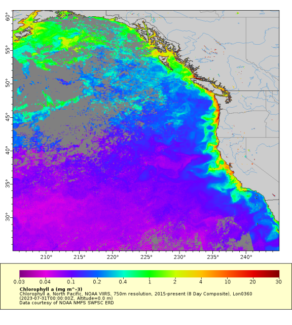
Collaborative Data Partnership Providing Fuller, More Robust Picture of Conditions in Northeast Pacific
A new data initiative involving more than 20 years of oceanographic data from Olympic Coast National Marine Sanctuary (OCNMS) promises to provide scientists and the public with a more robust picture of changing ocean conditions within the sanctuary and Northeast Pacific Ocean.
Funded by the National Oceanic and Atmospheric Administration’s (NOAA) Climate Program Office, a team from Oregon State University is working to make 23 years of sanctuary mooring data and data from CTD (Conductivity, Temperature, and Depth) casts available through publicly accessible data repositories. The three-year project will also combine the sanctuary’s data with complementary data sets in the region, including data from the Ocean ObservatorIes Initiative (OOI) Coastal Endurance Array.
“The OCNMS data are a critically important data set that has not been fully unlocked and represents a treasure chest of information that we’ve only begun to crack open,” said Jenny Waddell, research coordinator at Olympic Coast National Marine Sanctuary and a collaborator on the project. “The data will provide information about marine heat waves, changes in timing of spring transition to upwelling, seasonal hypoxia, and ocean acidification, all of which will help improve the management of marine resources in the sanctuary.”
Olympic Coast National Marine Sanctuary, along Washington State’s outer coast, represents one of North America’s most productive marine ecosystems. An area of summertime upwelling of cold nutrient-rich waters, the sanctuary hosts a diverse ecosystem that is home to many commercially and culturally important fisheries.
[media-caption path="https://oceanobservatories.org/wp-content/uploads/2023/06/SP_stern_JWaddell_Aug2021.jpeg" link="#"]The stern of the R/V Storm Petrel hints at some of the enhanced capacity that this new vessel brings to research on the Olympic Coast, including a larger work area on the back deck, an upper deck for seabird and mammal surveys, a new pot hauler and knuckle boom crane, and a much more capable A-frame and winch. Credit: Jenny Waddell © NOAA.[/media-caption]Collected by 10 oceanographic moorings, the process of taking 23 years of the sanctuary’s quality-controlled data (water temperature, salinity, density, spiciness, velocity, and dissolved oxygen concentration) and meshing them with data from 700 CTD casts is a huge undertaking that will be conducted in multiple steps. The first step was the handover of all processed and raw data by the sanctuary to data experts Brandy Cervantes and Craig Risien at OSU. The data experts, who are Co-PIs on the NOAA project, are going through all the data and reprocessing where necessary to make sure that all the data are interoperable. The high-resolution CTD data are of particular interest, having never been made widely available before. These data will provide information about the water column to complement and validate the data collected by the instruments on the moorings.
OOI’s Contribution
The Coastal Endurance Array’s Washington Inshore mooring is the shallowest of the three OOI moorings off Washington State and lies just inside the sanctuary’s southern boundary. This location helps provide an in-depth look at ongoing conditions nearer the coast. While the other two Endurance Array moorings off Washington State are farther offshore and to the south, not formally within the sanctuary boundaries, they provide valuable year-round data, which are particularly helpful for context on conditions farther offshore from the sanctuary and for regional forecasting and prediction efforts of ocean conditions. Sanctuary moorings are seasonal, collecting data when they are deployed in May through the first week of October when they are recovered, except for a single overwintering mooring, so OOI data also provide important year-round context for OCNMS.
“Data from the other two Endurance Array moorings not within the sanctuary boundary are equally valuable, not just for prediction purposes, but to our tribal partners. A unique thing about the Olympic Coast National Marine Sanctuary is that nearly the entire sanctuary is within the Usual and Accustomed Fishing Areas of the four coastal treaty tribes in Washington — the Hoh Tribe, Makah Tribe, Quileute Tribe, and the Quinault Indian Nation. The sanctuary and OOI-derived data are particularly valuable to the Quinault Tribe, who use these data to estimate fish runs. They have found, for example, that our oxygen data are a good predictor of the Coho salmon run size in some of the coastal rivers,” Waddell explained.
Olympic Coast Data Applications
Sanctuary data are the foundation of the LiveOcean model, an ongoing project of the University of Washington Coastal Modeling Group that provides short-term (three-day) forecasts of ocean conditions—currents, temperature, salinity and biogeochemical fields such as harmful algal blooms. Sanctuary data also are incorporated in the J-SCOPE model, operated by the Northwest Association of Networked Ocean Observing Systems (NANOOS), for seasonal (six to nine month) forecasts of ocean conditions that are relevant to management decisions for fisheries, protected species, and ecosystem health.
Sanctuary and OOI data also serve as the basis for novel estimates of pre-industrial and near future (2030–2050) ocean acidification conditions on the Olympic Coast led by NOAA Pacific Marine Environmental Laboratory ocean carbon scientists. These estimates are made possible by rich NOAA Ocean Acidification Program-funded coastal observing efforts and inform state and tribal fisheries and water quality management (cf. Alin et al. 2023 in press).
Changing Conditions
“In the 23 years that we’ve been collecting data, we have been documenting changing ocean conditions that are quite alarming,” said Waddell. The 465-page latest Condition Report for the Sanctuary details how ocean conditions along the Olympic Coast continue to change and intensify in response to climate change. The report lays out concerns about the impacts from ocean acidification, warming ocean temperatures, increased stratification, rising sea levels, and declines in dissolved oxygen, in addition to the intermittent occurrences from more intense and frequent marine heatwaves, harmful algal blooms, and coastal storms.
[media-caption path="https://oceanobservatories.org/wp-content/uploads/2023/06/IMG_4898.jpg" link="#"]Oceanographic moorings deployed by Olympic Coast National Marine Sanctuary, such as this mooring near Cape Alava, have been tracking changes in ocean conditions along this remote and rugged coastline for more than two decades. Credit: Jenny Waddell ©NOAA.[/media-caption]To help bring this information to the public, the sanctuary has developed a user-friendly and searchable graphic interface that provides easy access to data within the report. Called the Web Condition Report (WebCR), the interface is designed to connect people with information they are interested in.
[media-caption path="https://oceanobservatories.org/wp-content/uploads/2023/06/OCNMS_O2_plots_5panel_2018-scaled.jpg" link="#"]
This is an example of the type of information available through WebCR. Like animals on land, most marine animal species need oxygen to survive. To obtain oxygen, whales and turtles periodically breathe air at the water’s surface, while most fish species obtain oxygen that is dissolved in seawater. Low oxygen levels can harm marine animals or force them to move to areas with more hospitable conditions. Cape Elizabeth in the south (2006–2017), for example, has gotten progressively worse over time and in recent years is hypoxic 44 percent of the time. Image source: Alin et al., 2023 in prep. Also reprinted from: Office of National Marine Sanctuaries. 2022. Olympic Coast National Marine Sanctuary Condition Report: 2008–2019. U.S. Department of Commerce, National Oceanic and Atmospheric Administration, Office of National Marine Sanctuaries, Silver Spring, MD. 453 pp.[/media-caption] “These 23 years of data now being sorted will help us get a handle on what is really going on in the Pacific Northwest. It’s an important microcosm of what’s happening on a larger scale. Only around 25,000 people live along the Olympic Coast between Neah Bay and Ocean Shores, so the human footprint of this place is minimal. Most of what we’re seeing and what the data are telling us are climate forced issues coming to bear here,” added Waddell. “And having our data in the hands of senior oceanographers who know exactly what to do with it is just so incredibly valuable to understand not only what’s happening at the ocean surface, but within the full water column, which is where most of the impacts of climate change are occurring.”
The Principal Investigator (PI) for this project is College of Earth, Ocean and Atmospheric Science (CEOAS) Oregon State University (OSU) Associate Professor Melanie R. Fewings. Co-principal Investigators are Craig M. Risien, OSU Senior Faculty Research Assistant II and OOI Cyberinfrastructure Project Manager; Co-Principal Investigator Brandy T. Cervantes, OSU Senior Research Associate.
In addition to the PIs and NOAA’s Waddell, other collaborators include Dr. Simone Alin, NOAA Pacific Marine Environmental Laboratory, Katie Wrubel, Resource Protection Specialist, OCNMS, Joe Schumacker, Marine Resources Scientist, Quinault Indian Nation, Dept. of Fisheries, Tommy Moore, Oceanographer, Northwest Indian Fisheries Commission, Charles Seaton, Senior Oceanographer, Columbia River Inter-Tribal Fish Commission, Kym Jacobson, Research Zoologist, NOAA Northwest Fisheries Science Center, Jennifer Fisher, NOAA Cooperative Institute for Marine Ecosystem and Resources Studies, OSU, and Maria Kavanaugh, Assistant Professor, CEOAS, OSU, and Principal Investigator of the Marine Biodiversity Network.
Read More
NSF Large Facilities Team Visits OOI at WHOI
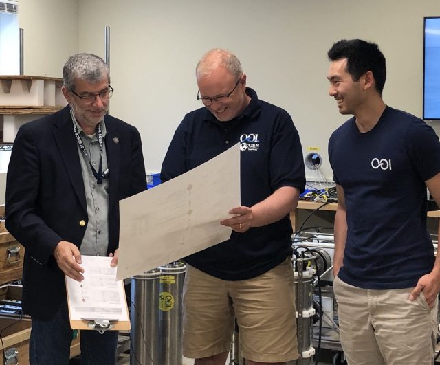
Representatives from the National Science Foundation’s (NSF) Large Facilities Office visited Woods Hole Oceanographic Institution (WHOI) on Monday June 26-Tuesday June 27 to get a first-hand look at the various facilities at WHOI supported by the NSF. The visit kicked off at LOSOS on the Quissett Campus with a discussion of the Ocean Observatories Initiative (OOI), followed by a tour of its facilities.
OOI’s program office (PMO) is located at WHOI and led by Principle Investigator Jim Edson. On Monday morning, Edson welcomed the NSF visitors, introduced the PMO team, and provided an overview of OOI’s organization, operations, and how scientists are using its data to expand understanding of ocean processes and conditions. OOI Senior Program Manager Paul Matthias followed with a technical presentation of how this large and complex program is managed, kept on budget with continuous collection and disseminating of OOI data.
[media-caption path="https://oceanobservatories.org/wp-content/uploads/2023/06/IMG_1148-2-scaled.jpg" link="#"]WHOI Assistant Scientist Hilde Oliver gave a lightning talk on how she used OOI data to explain the role of wind in ephemeral surface chlorophyll enhancement at the New England Shelf Break. [/media-caption]A Q&A session was held over lunch. The afternoon session commenced with virtual presentations by the OOI Data Center at Oregon State University, followed by a review of major components, organization, and operations of three OOI components – Coastal Endurance Array at Oregon State University, Coastal and Global Scale Nodes at WHOI, and the Regional Cabled Array at the University of Washington. A tour of LOSOS followed the presentations.
[media-caption path="https://oceanobservatories.org/wp-content/uploads/2023/06/IMG_1163-scaled.jpg" link="#"]OOI Instrumentation Lead Jennifer Batryn took apart an Acoustic Doppler Current Profiler (ADCP) during a tour of the LOSOS electronics lab during an NSF visit. [/media-caption]The NSF visitors attending the daylong session focused on OOI were Linnea Avallone, Chief Officer for NSF Research Facilities, Jim McManus, Director Division of Ocean Sciences, and George Voulgaris, OOI Program Manager. Rose Dufour, Program Director Ship Operations, joined the group for a tour of the OOI facilities in LOSOS.
“We were delighted to have the opportunity to show off the technically advanced and rugged OOI ocean observing equipment and the amazing talents of the team who designs, builds, maintains, and keeps this equipment operating in difficult conditions to our NSF colleagues,” said Jim Edson, Lead PI of OOI’s Program Office. “Seeing the size and scope of the equipment firsthand gives one a real understanding of the complexity of OOI operations and the importance of the data being collected and integrated into research.”
The NSF visitors returned to WHOI on Tuesday morning to visit and learn more about other NSF-sponsored programs at WHOI, including a visit to the National Deep Submergence Facility, ship operations, the Northeast U.S. Shelf (NES) Long-Term Ecological Research (LTER) project, and the Center for Chemical Currencies of a Microbial Planet.
OOI Program Director George Voulgaris spent the second day of his visit to WHOI with members of OOI’s Program Office and the Coastal and Global Scale Nodes (CGSN) team. On Tuesday, CGSN members showed off their northern LOSOS facility, where they were burning in equipment for deployment at the Global Irminger Sea Array this summer and testing two Autonomous Underwater Vehicles (AUV) prior to deployment. The visit ended with a pizza lunch that provided Voulgaris an opportunity to meet all members of the CGSN team and learn more about their individual roles and responsibilities.
[media-caption path="https://oceanobservatories.org/wp-content/uploads/2023/06/IMG_1168-scaled.jpg" link="#"]George Voulgaris, OOI Program Manager (left) discusses mooring issues with OOI Senior Program Manager Paul Matthias, and OOI Lead Jim Edson during a tour of the LOSOS outdoor facility, where segments of OOI moorings are stored prior to mobilization. [/media-caption] [media-caption path="https://oceanobservatories.org/wp-content/uploads/2023/06/IMG_1172-scaled.jpg" link="#"]OOI Coastal and Global Scale Nodes Project Manager Derek Buffitt explains the components that comprise the Multi-Function Node, which holds the anchor and instrumentation near the bottom of the OOI arrays, to Linnea Avallone, Chief Officer for NSF Research Facilities during a tour of OOI LOSOS. [/media-caption] [media-caption path="https://oceanobservatories.org/wp-content/uploads/2023/06/IMG_1197-scaled.jpg" link="#"]OOI Glider Lead Peter Brickley explains the operation of the tail fin and air bladder of an OOI glider to NSF OOI Program Director George Voulgaris. [/media-caption] [media-caption path="https://oceanobservatories.org/wp-content/uploads/2023/06/IMG_1226-scaled.jpg" link="#"]NSF OOI Program Director George Voulgaris (left) reviews the components of a global surface mooring with OOI Senior Engineer John Lund and Research Engineer James Kuo. [/media-caption] [media-caption path="https://oceanobservatories.org/wp-content/uploads/2023/06/IMG_1235-scaled.jpg" link="#"]Glider Lead Peter Brickley explains the operations of the Autonomous Underwater Vehicle (AUV), REMUS to NSF OOI Program Director George Voulgaris. Diana Wickman, left rear, who keeps the AUVs operational was on hand for the presentation and to answer questions about the vehicle’s operations, as well. [/media-caption]Photos taken by Darlene Trew Crist © WHOI.
Read More