
CP16MOAS
Alongside Coastal Gliders, Coastal Autonomous Underwater Vehicles (AUVs) are a Mobile Asset that surveys the area in and around the array of moorings at the Coastal Pioneer MAB Array
Platform DOI and Citation Guidance
OOI assigns Digital Object Identifiers (DOIs) at the platform or site level. The DOI for the Coastal Pioneer Mid-Atlantic Bight Mobile Asset Autonomous Underwater Vehicles is 10.58046/OOI-CP16MOAS.
The minimum recommended citation for this platform is:
NSF Ocean Observatories Initiative. (2024). Coastal Pioneer Mid-Atlantic Bight Mobile Asset Autonomous Underwater Vehicles, DOI: 10.58046/OOI-CP16MOAS.
This follows the format NSF Ocean Observatories Initiative. (Year Published). Platform Title, DOI: Platform DOI, where Year Published is the year OOI data collection began at the site.
We encourage data users to incorporate full citations when referencing OOI data in order to support FAIR data principles and data traceability. OOI also provides further guidance on citations, including information on adding specific data products and data access points to citations.
Data Access
The following links provide data access via Data Explorer or other methods:
- Direct access to the data on this platform and its subcomponents
- General access to OOI data using a variety of methods
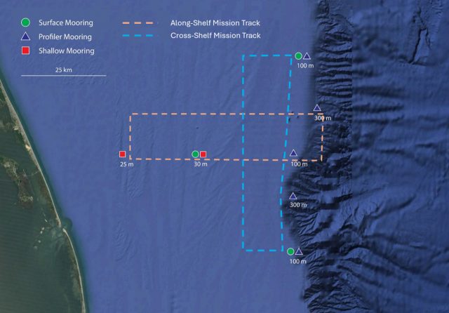
AUV Mission Tracks
- Cross-Shelf, providing synoptic cross-shelf “snapshots” of the frontal zone.
- Along-Shelf, providing synoptic along-shelf “snapshots” of submesoscale structure in the vicinity of the shelfbreak front.
Two Coastal AUVs (HII REMUS-600 AUVs) travel along transects across the shelf-break frontal system extending beyond the mooring array, covering an area approximately 1000 square kilometers in size centered on the array of moorings. The primary role of the AUVs is to resolve cross- and along-front “eddy fluxes” due to frontal instabilities, wind forcing, and mesoscale variability. These AUVs travel along saw-toothed transects, penetrating the sea surface and diving down to a maximum depth of 600 meters.
Read MoreCP15MOAS
Coastal Gliders are one kind of Mobile Asset that survey the area in and around the array of moorings at the Coastal Pioneer MAB Array.
Platform DOI and Citation Guidance
OOI assigns Digital Object Identifiers (DOIs) at the platform or site level. The DOI for the Coastal Pioneer Mid-Atlantic Bight Mobile Asset Gliders is 10.58046/OOI-CP15MOAS.
The minimum recommended citation for this platform is:
NSF Ocean Observatories Initiative. (2024). Coastal Pioneer Mid-Atlantic Bight Mobile Asset Gliders, DOI: 10.58046/OOI-CP15MOAS.
This follows the format NSF Ocean Observatories Initiative. (Year Published). Platform Title, DOI: Platform DOI, where Year Published is the year OOI data collection began at the site.
We encourage data users to incorporate full citations when referencing OOI data in order to support FAIR data principles and data traceability. OOI also provides further guidance on citations, including information on adding specific data products and data access points to citations.
Data Access
The following links provide data access via Data Explorer or other methods:
- Direct access to the data on this platform and its subcomponents
- General access to OOI data using a variety of methods
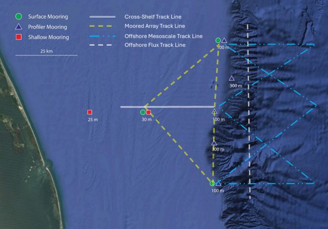
Glider Track Lines
- Offshore Flux, providing repeat north-south transects, nominally over the 1000 m isobath, to allow estimation of cross-shelf fluxes.
- Moored Array, providing repeat along-shelf transects at ~100 m depth while circumnavigating a triangle created by the three Coastal Surface Moorings
- Offshore Mesoscale, providing information about mesoscale features within the slope sea that may impinge on the continental shelf.
- Cross-Shelf, providing repeat cross-shelf transects along the east-west moored array line from the shelfbreak to ~30 m depth.
Four Coastal Gliders (Teledyne-Webb Slocum Gliders) sample large, mesoscale features through a broad region (2900 square kilometers) of the outer continental shelf between the shelf break and the Gulf Stream. The role of these gliders in monitoring this broader area is to resolve rings, eddies and meanders from the Gulf Stream as they impinge on the shelf break front. These Teledyne-Webb Slocum Gliders fly through the water column along saw-tooth paths, penetrating the sea surface and diving down to a maximum depth of 1000 meters.
Read MoreCP14SEPM
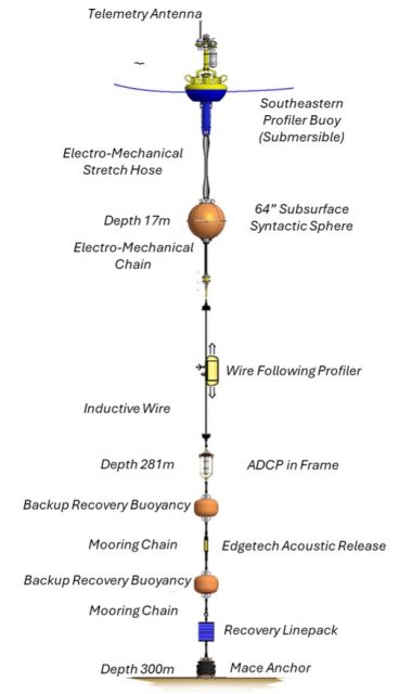
The Coastal Pioneer Mid-Atlantic Bight Southeastern Profiler Mooring is located on the Continental Shelf, approximately 300 meters deep. The MAB continental shelf north of Cape Hatteras is characterized by a persistent equator-ward current originating from the north, a shelfbreak front separating shelf and slope waters, distributed buoyancy inputs from rivers, variable wind forcing, and intermittent offshore forcing by Gulf Stream meanders.
Platform DOI and Citation Guidance
OOI assigns Digital Object Identifiers (DOIs) at the platform or site level. The DOI for the Coastal Pioneer Mid-Atlantic Bight Southeastern Profiler Mooring is 10.58046/OOI-CP14SEPM.
The minimum recommended citation for this platform is:
NSF Ocean Observatories Initiative. (2024). Coastal Pioneer Mid-Atlantic Bight Southeastern Profiler Mooring, DOI: 10.58046/OOI-CP14SEPM.
This follows the format NSF Ocean Observatories Initiative. (Year Published). Platform Title, DOI: Platform DOI, where Year Published is the year OOI data collection began at the site.
We encourage data users to incorporate full citations when referencing OOI data in order to support FAIR data principles and data traceability. OOI also provides further guidance on citations, including information on adding specific data products and data access points to citations.
Data Access
The following links provide data access via Data Explorer or other methods:
- Direct access to the data on this platform and its subcomponents
- General access to OOI data using a variety of methods
Platform Description
The Pioneer MAB Southeastern Profiler Mooring is located on the Continental Shelf, approximately 300 meters deep. The MAB continental shelf north of Cape Hatteras is characterized by a persistent equator-ward current originating from the north, a shelfbreak front separating shelf and slope waters, distributed buoyancy inputs from rivers, variable wind forcing, and intermittent offshore forcing by Gulf Stream meanders. The Pioneer MAB Array is designed to resolve transport processes and ecosystem dynamics in the vicinity of the shelfbreak front, which is a region of complex oceanographic dynamics, intermittent mesoscale variability, and enhanced biological productivity.
Like other Coastal Profiler Moorings, the Pioneer MAB Southeastern Profiler Mooring instruments are mounted on the Surface Buoy, Subsurface Sphere, within the Wire-Following Profiler, and on a frame on the riser wire. The Wire-Following Profiler moves through the water column along the mooring riser, continuously sampling ocean characteristics over a specified depth interval. The instruments communicate with the Surface Buoy through the inductive riser wire. Additionally, the Surface Buoy contains antennas to transmit data to shore via satellite.
Read MoreCP14NEPM
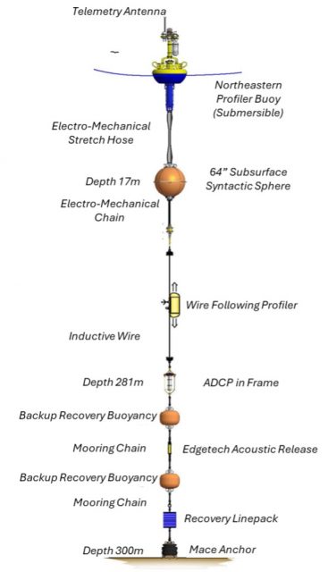
The Coastal Pioneer Mid-Atlantic Bight Northeastern Profiler Mooring is located on the Continental Shelf, approximately 300 meters deep. The MAB continental shelf north of Cape Hatteras is characterized by a persistent equator-ward current originating from the north, a shelfbreak front separating shelf and slope waters, distributed buoyancy inputs from rivers, variable wind forcing, and intermittent offshore forcing by Gulf Stream meanders.
Platform DOI and Citation Guidance
OOI assigns Digital Object Identifiers (DOIs) at the platform or site level. The DOI for the Coastal Pioneer Mid-Atlantic Bight Northeastern Profiler Mooring is 10.58046/OOI-CP14NEPM.
The minimum recommended citation for this platform is:
NSF Ocean Observatories Initiative. (2024). Coastal Pioneer Mid-Atlantic Bight Northeastern Profiler Mooring, DOI: 10.58046/OOI-CP14NEPM.
This follows the format NSF Ocean Observatories Initiative. (Year Published). Platform Title, DOI: Platform DOI, where Year Published is the year OOI data collection began at the site.
We encourage data users to incorporate full citations when referencing OOI data in order to support FAIR data principles and data traceability. OOI also provides further guidance on citations, including information on adding specific data products and data access points to citations.
Data Access
The following links provide data access via Data Explorer or other methods:
- Direct access to the data on this platform and its subcomponents
- General access to OOI data using a variety of methods
Platform Description
The Pioneer MAB Northeastern Profiler Mooring is located on the Continental Shelf, approximately 300 meters deep. The MAB continental shelf north of Cape Hatteras is characterized by a persistent equator-ward current originating from the north, a shelfbreak front separating shelf and slope waters, distributed buoyancy inputs from rivers, variable wind forcing, and intermittent offshore forcing by Gulf Stream meanders. The Pioneer MAB Array is designed to resolve transport processes and ecosystem dynamics in the vicinity of the shelfbreak front, which is a region of complex oceanographic dynamics, intermittent mesoscale variability, and enhanced biological productivity.
Like other Coastal Profiler Moorings, the Pioneer MAB Northeastern Profiler Mooring instruments are mounted on the Surface Buoy, Subsurface Sphere, within the Wire-Following Profiler, and on a frame on the riser wire. The Wire-Following Profiler moves through the water column along the mooring riser, continuously sampling ocean characteristics over a specified depth interval. The instruments communicate with the Surface Buoy through the inductive riser wire. Additionally, the Surface Buoy contains antennas to transmit data to shore via satellite.
Read MoreCP13SOPM
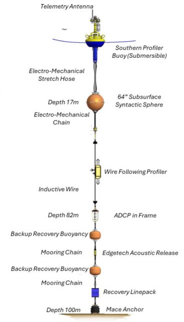
The Coastal Pioneer Mid-Atlantic Bight Southern Profiler Mooring is located on the Continental Shelf, approximately 100 meters deep. The MAB continental shelf north of Cape Hatteras is characterized by a persistent equator-ward current originating from the north, a shelfbreak front separating shelf and slope waters, distributed buoyancy inputs from rivers, variable wind forcing, and intermittent offshore forcing by Gulf Stream meanders.
Platform DOI and Citation Guidance
OOI assigns Digital Object Identifiers (DOIs) at the platform or site level. The DOI for the Coastal Pioneer Mid-Atlantic Bight Southern Profiler Mooring is 10.58046/OOI-CP13SOPM.
The minimum recommended citation for this platform is:
NSF Ocean Observatories Initiative. (2024). Coastal Pioneer Mid-Atlantic Bight Southern Profiler Mooring, DOI: 10.58046/OOI-CP13SOPM.
This follows the format NSF Ocean Observatories Initiative. (Year Published). Platform Title, DOI: Platform DOI, where Year Published is the year OOI data collection began at the site.
We encourage data users to incorporate full citations when referencing OOI data in order to support FAIR data principles and data traceability. OOI also provides further guidance on citations, including information on adding specific data products and data access points to citations.
Data Access
The following links provide data access via Data Explorer or other methods:
- Direct access to the data on this platform and its subcomponents
- General access to OOI data using a variety of methods
Platform Description
The Pioneer MAB Southern Profiler Mooring is located on the Continental Shelf, approximately 100 meters deep. The MAB continental shelf north of Cape Hatteras is characterized by a persistent equator-ward current originating from the north, a shelfbreak front separating shelf and slope waters, distributed buoyancy inputs from rivers, variable wind forcing, and intermittent offshore forcing by Gulf Stream meanders. The Pioneer MAB Array is designed to resolve transport processes and ecosystem dynamics in the vicinity of the shelfbreak front, which is a region of complex oceanographic dynamics, intermittent mesoscale variability, and enhanced biological productivity.
Like other Coastal Profiler Moorings, the Pioneer MAB Southern Profiler Mooring instruments are mounted on the Surface Buoy, Subsurface Sphere, within the Wire-Following Profiler, and on a frame on the riser wire. The Wire-Following Profiler moves through the water column along the mooring riser, continuously sampling ocean characteristics over a specified depth interval. The instruments communicate with the Surface Buoy through the inductive riser wire. Additionally, the Surface Buoy contains antennas to transmit data to shore via satellite.
Read MoreCP13NOPM

The Coastal Pioneer Mid-Atlantic Bight Northern Profiler Mooring is located on the Continental Shelf, approximately 100 meters deep. The MAB continental shelf north of Cape Hatteras is characterized by a persistent equator-ward current originating from the north, a shelfbreak front separating shelf and slope waters, distributed buoyancy inputs from rivers, variable wind forcing, and intermittent offshore forcing by Gulf Stream meanders.
Platform DOI and Citation Guidance
OOI assigns Digital Object Identifiers (DOIs) at the platform or site level. The DOI for the Coastal Pioneer Mid-Atlantic Bight Northern Profiler Mooring is 10.58046/OOI-CP13NOPM.
The minimum recommended citation for this platform is:
NSF Ocean Observatories Initiative. (2024). Coastal Pioneer Mid-Atlantic Bight Northern Profiler Mooring, DOI: 10.58046/OOI-CP13NOPM.
This follows the format NSF Ocean Observatories Initiative. (Year Published). Platform Title, DOI: Platform DOI, where Year Published is the year OOI data collection began at the site.
We encourage data users to incorporate full citations when referencing OOI data in order to support FAIR data principles and data traceability. OOI also provides further guidance on citations, including information on adding specific data products and data access points to citations.
Data Access
The following links provide data access via Data Explorer or other methods:
- Direct access to the data on this platform and its subcomponents
- General access to OOI data using a variety of methods
Platform Description
The Pioneer MAB Northern Profiler Mooring is located on the Continental Shelf, approximately 100 meters deep. The MAB continental shelf north of Cape Hatteras is characterized by a persistent equator-ward current originating from the north, a shelfbreak front separating shelf and slope waters, distributed buoyancy inputs from rivers, variable wind forcing, and intermittent offshore forcing by Gulf Stream meanders. The Pioneer MAB Array is designed to resolve transport processes and ecosystem dynamics in the vicinity of the shelfbreak front, which is a region of complex oceanographic dynamics, intermittent mesoscale variability, and enhanced biological productivity.
Like other Coastal Profiler Moorings, the Pioneer MAB Northern Profiler Mooring instruments are mounted on the Surface Buoy, Subsurface Sphere, within the Wire-Following Profiler, and on a frame on the riser wire. The Wire-Following Profiler moves through the water column along the mooring riser, continuously sampling ocean characteristics over a specified depth interval. The instruments communicate with the Surface Buoy through the inductive riser wire. Additionally the Surface Buoy contains antennas to transmit data to shore via satellite.
Read MoreCP13EAPM

The Coastal Pioneer Mid-Atlantic Bight Eastern Profiler Mooring is located on the Continental Shelf, approximately 100 meters deep. The MAB continental shelf north of Cape Hatteras is characterized by a persistent equator-ward current originating from the north, a shelfbreak front separating shelf and slope waters, distributed buoyancy inputs from rivers, variable wind forcing, and intermittent offshore forcing by Gulf Stream meanders.
Platform DOI and Citation Guidance
OOI assigns Digital Object Identifiers (DOIs) at the platform or site level. The DOI for the Coastal Pioneer Mid-Atlantic Bight Eastern Profiler Mooring is 10.58046/OOI-CP13EAPM.
The minimum recommended citation for this platform is:
NSF Ocean Observatories Initiative. (2024). Coastal Pioneer Mid-Atlantic Bight Eastern Profiler Mooring, DOI: 10.58046/OOI-CP13EAPM.
This follows the format NSF Ocean Observatories Initiative. (Year Published). Platform Title, DOI: Platform DOI, where Year Published is the year OOI data collection began at the site.
We encourage data users to incorporate full citations when referencing OOI data in order to support FAIR data principles and data traceability. OOI also provides further guidance on citations, including information on adding specific data products and data access points to citations.
Data Access
The following links provide data access via Data Explorer or other methods:
- Direct access to the data on this platform and its subcomponents
- General access to OOI data using a variety of methods
Platform Description
The Pioneer MAB Eastern Profiler Mooring is located on the Continental Shelf, approximately 100 meters deep. The MAB continental shelf north of Cape Hatteras is characterized by a persistent equator-ward current originating from the north, a shelfbreak front separating shelf and slope waters, distributed buoyancy inputs from rivers, variable wind forcing, and intermittent offshore forcing by Gulf Stream meanders. The Pioneer MAB Array is designed to resolve transport processes and ecosystem dynamics in the vicinity of the shelfbreak front, which is a region of complex oceanographic dynamics, intermittent mesoscale variability, and enhanced biological productivity.
Like other Coastal Profiler Moorings, the Pioneer MAB Eastern Profiler Mooring instruments are mounted on the Surface Buoy, Subsurface Sphere, within the Wire-Following Profiler, and on a frame on the riser wire. The Wire-Following Profiler moves through the water column along the mooring riser, continuously sampling ocean characteristics over a specified depth interval. The instruments communicate with the Surface Buoy through the inductive riser wire. Additionally the Surface Buoy contains antennas to transmit data to shore via satellite.
Read MoreCP12CNSW
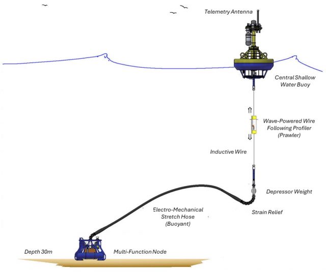
The Coastal Pioneer Mid-Atlantic Bight Central Shallow Water Mooring is located on the Continental Shelf, approximately 30 meters deep. The MAB continental shelf north of Cape Hatteras is characterized by a persistent equator-ward current originating from the north, a shelfbreak front separating shelf and slope waters, distributed buoyancy inputs from rivers, variable wind forcing, and intermittent offshore forcing by Gulf Stream meanders.
Platform DOI and Citation Guidance
OOI assigns Digital Object Identifiers (DOIs) at the platform or site level. The DOI for the Coastal Pioneer Mid-Atlantic Bight Central Shallow Water Mooring is 10.58046/OOI-CP12CNSW.
The minimum recommended citation for this platform is:
NSF Ocean Observatories Initiative. (2024). Coastal Pioneer Mid-Atlantic Bight Central Shallow Water Mooring, DOI: 10.58046/OOI-CP12CNSW.
This follows the format NSF Ocean Observatories Initiative. (Year Published). Platform Title, DOI: Platform DOI, where Year Published is the year OOI data collection began at the site.
We encourage data users to incorporate full citations when referencing OOI data in order to support FAIR data principles and data traceability. OOI also provides further guidance on citations, including information on adding specific data products and data access points to citations.
Data Access
The following links provide data access via Data Explorer or other methods:
- Direct access to the data on this platform and its subcomponents
- General access to OOI data using a variety of methods
Platform Description
The Pioneer MAB Central Shallow Water Mooring is located on the Continental Shelf, approximately 30 meters deep. The MAB continental shelf north of Cape Hatteras is characterized by a persistent equator-ward current originating from the north, a shelfbreak front separating shelf and slope waters, distributed buoyancy inputs from rivers, variable wind forcing, and intermittent offshore forcing by Gulf Stream meanders. The Pioneer MAB Array is designed to resolve transport processes and ecosystem dynamics in the vicinity of the shelfbreak front, which is a region of complex oceanographic dynamics, intermittent mesoscale variability, and enhanced biological productivity.
Like other moorings, the Pioneer MAB Central Shallow Water Mooring is specifically designed to examine coastal-scale phenomena and withstand the challenging conditions of shallow coastal environments. The Shallow Water Mooring contains instruments attached to a Surface Buoy floating on the sea surface, the wave-powered Wire Following Profiler, and a Multi-Function Node (MFN) located on the seafloor. The Profiler and the MFN instruments communicate with the Surface Buoy through the inductive riser wire. Additionally, the Surface Buoy contains antennas to transmit data to shore via satellite.
Read MoreCP11SOSM

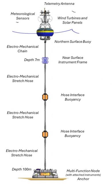
The Coastal Pioneer Mid-Atlantic Bight Southern Surface Mooring is located on the Continental Shelf, approximately 100 meters deep. The MAB continental shelf north of Cape Hatteras is characterized by a persistent equator-ward current originating from the north, a shelfbreak front separating shelf and slope waters, distributed buoyancy inputs from rivers, variable wind forcing, and intermittent offshore forcing by Gulf Stream meanders.
Platform DOI and Citation Guidance
OOI assigns Digital Object Identifiers (DOIs) at the platform or site level. The DOI for the Coastal Pioneer Mid-Atlantic Bight Southern Surface Mooring is 10.58046/OOI-CP11SOSM.
The minimum recommended citation for this platform is:
NSF Ocean Observatories Initiative. (2024). Coastal Pioneer Mid-Atlantic Bight Southern Surface Mooring, DOI: 10.58046/OOI-CP11SOSM.
This follows the format NSF Ocean Observatories Initiative. (Year Published). Platform Title, DOI: Platform DOI, where Year Published is the year OOI data collection began at the site.
We encourage data users to incorporate full citations when referencing OOI data in order to support FAIR data principles and data traceability. OOI also provides further guidance on citations, including information on adding specific data products and data access points to citations.
Data Access
The following links provide data access via Data Explorer or other methods:
- Direct access to the data on this platform and its subcomponents
- General access to OOI data using a variety of methods
Platform Description
The Pioneer MAB Southern Surface Mooring is located on the Continental Shelf, approximately 100 meters deep. The MAB continental shelf north of Cape Hatteras is characterized by a persistent equator-ward current originating from the north, a shelfbreak front separating shelf and slope waters, distributed buoyancy inputs from rivers, variable wind forcing, and intermittent offshore forcing by Gulf Stream meanders. The Pioneer MAB Array is designed to resolve transport processes and ecosystem dynamics in the vicinity of the shelfbreak front, which is a region of complex oceanographic dynamics, intermittent mesoscale variability, and enhanced biological productivity.
Like other coastal moorings, the Pioneer MAB Southern Surface Mooring is specifically designed to examine coastal-scale phenomena and withstand the challenging conditions of shallow coastal environments. The Surface Mooring contains instruments attached to a Surface Buoy floating on the sea surface, Near Surface Instrument Frame 7 meters below the surface, and a Seafloor Multi-Function Node (MFN) located on the seafloor. The Surface Buoy provides a platform on which to secure surface instruments above the sea surface, below the sea surface, and across the interface between. Additionally, the Surface Buoy contains antennas to transmit data to shore via satellite.
Read MoreCP11NOSM
The Coastal Pioneer Mid-Atlantic Bight Northern Surface Mooring is located on the Continental Shelf, approximately 100 meters deep. The MAB continental shelf north of Cape Hatteras is characterized by a persistent equator-ward current originating from the north, a shelfbreak front separating shelf and slope waters, distributed buoyancy inputs from rivers, variable wind forcing, and intermittent offshore forcing by Gulf Stream meanders.
Platform DOI and Citation Guidance
OOI assigns Digital Object Identifiers (DOIs) at the platform or site level. The DOI for the Coastal Pioneer Mid-Atlantic Bight Northern Surface Mooring is 10.58046/OOI-CP11NOSM.
The minimum recommended citation for this platform is:
NSF Ocean Observatories Initiative. (2024). Coastal Pioneer Mid-Atlantic Bight Northern Surface Mooring, DOI: 10.58046/OOI-CP11NOSM.
This follows the format NSF Ocean Observatories Initiative. (Year Published). Platform Title, DOI: Platform DOI, where Year Published is the year OOI data collection began at the site.
We encourage data users to incorporate full citations when referencing OOI data in order to support FAIR data principles and data traceability. OOI also provides further guidance on citations, including information on adding specific data products and data access points to citations.
Data Access
The following links provide data access via Data Explorer or other methods:
- Direct access to the data on this platform and its subcomponents
- General access to OOI data using a variety of methods
Platform Description
The Pioneer MAB Northern Surface Mooring is located on the Continental Shelf, approximately 100 meters deep. The MAB continental shelf north of Cape Hatteras is characterized by a persistent equator-ward current originating from the north, a shelfbreak front separating shelf and slope waters, distributed buoyancy inputs from rivers, variable wind forcing, and intermittent offshore forcing by Gulf Stream meanders. The Pioneer MAB Array is designed to resolve transport processes and ecosystem dynamics in the vicinity of the shelfbreak front, which is a region of complex oceanographic dynamics, intermittent mesoscale variability, and enhanced biological productivity.
Like other coastal moorings, the Pioneer MAB Northern Surface Mooring is specifically designed to examine coastal-scale phenomena and withstand the challenging conditions of shallow coastal environments. The Surface Mooring contains instruments attached to a Surface Buoy floating on the sea surface, Near Surface Instrument Frame 7 meters below the surface, and a Seafloor Multi-Function Node (MFN) located on the seafloor. The Surface Buoy provides a platform on which to secure surface instruments above the sea surface, below the sea surface, and across the interface between. Additionally the Surface Buoy contains antennas to transmit data to shore via satellite
Read More