
CP12WESW

The Coastal Pioneer Mid-Atlantic Bight Western Shallow Water Mooring is located on the Continental Shelf, approximately 25 meters deep. The MAB continental shelf north of Cape Hatteras is characterized by a persistent equator-ward current originating from the north, a shelfbreak front separating shelf and slope waters, distributed buoyancy inputs from rivers, variable wind forcing, and intermittent offshore forcing by Gulf Stream meanders.
Platform DOI and Citation Guidance
OOI assigns Digital Object Identifiers (DOIs) at the platform or site level. The DOI for the Coastal Pioneer Mid-Atlantic Bight Western Shallow Water Mooring is 10.58046/OOI-CP12WESW.
The minimum recommended citation for this platform is:
NSF Ocean Observatories Initiative. (2024). Coastal Pioneer Mid-Atlantic Bight Western Shallow Water Mooring, DOI: 10.58046/OOI-CP12WESW.
This follows the format NSF Ocean Observatories Initiative. (Year Published). Platform Title, DOI: Platform DOI, where Year Published is the year OOI data collection began at the site.
We encourage data users to incorporate full citations when referencing OOI data in order to support FAIR data principles and data traceability. OOI also provides further guidance on citations, including information on adding specific data products and data access points to citations.
Data Access
The following links provide data access via Data Explorer or other methods:
- Direct access to the data on this platform and its subcomponents
- General access to OOI data using a variety of methods
Platform Description
The Pioneer MAB Western Shallow Water Mooring is located on the Continental Shelf, approximately 25 meters deep. The MAB continental shelf north of Cape Hatteras is characterized by a persistent equator-ward current originating from the north, a shelfbreak front separating shelf and slope waters, distributed buoyancy inputs from rivers, variable wind forcing, and intermittent offshore forcing by Gulf Stream meanders. The Pioneer MAB Array is designed to resolve transport processes and ecosystem dynamics in the vicinity of the shelfbreak front, which is a region of complex oceanographic dynamics, intermittent mesoscale variability, and enhanced biological productivity.
Like other moorings, the Pioneer MAB Western Shallow Water Mooring is specifically designed to examine coastal-scale phenomena and withstand the challenging conditions of shallow coastal environments. The Shallow Water Mooring contains instruments attached to a Surface Buoy floating on the sea surface, the wave-powered Wire Following Profiler, and a Multi-Function Node (MFN) located on the seafloor. The Profiler and the MFN instruments communicate with the Surface Buoy through the inductive riser wire. Additionally, the Surface Buoy contains antennas to transmit data to shore via satellite.
Read MoreCP10CNSM

The Coastal Pioneer Mid-Atlantic Bight Central Surface Mooring is located on the Continental Shelf, approximately 30 meters deep. The MAB continental shelf north of Cape Hatteras is characterized by a persistent equator-ward current originating from the north, a shelfbreak front separating shelf and slope waters, distributed buoyancy inputs from rivers, variable wind forcing, and intermittent offshore forcing by Gulf Stream meanders.
Platform DOI and Citation Guidance
OOI assigns Digital Object Identifiers (DOIs) at the platform or site level. The DOI for the Coastal Pioneer Mid-Atlantic Bight Central Surface Mooring is 10.58046/OOI-CP10CNSM.
The minimum recommended citation for this platform is:
NSF Ocean Observatories Initiative. (2024). Coastal Pioneer Mid-Atlantic Bight Central Surface Mooring, DOI: 10.58046/OOI-CP10CNSM.
This follows the format NSF Ocean Observatories Initiative. (Year Published). Platform Title, DOI: Platform DOI, where Year Published is the year OOI data collection began at the site.
We encourage data users to incorporate full citations when referencing OOI data in order to support FAIR data principles and data traceability. OOI also provides further guidance on citations, including information on adding specific data products and data access points to citations.
Data Access
The following links provide data access via Data Explorer or other methods:
- Direct access to the data on this platform and its subcomponents
- General access to OOI data using a variety of methods
Platform Description
The Pioneer MAB Central Surface Mooring is located on the Continental Shelf, approximately 30 meters deep. The MAB continental shelf north of Cape Hatteras is characterized by a persistent equator-ward current originating from the north, a shelfbreak front separating shelf and slope waters, distributed buoyancy inputs from rivers, variable wind forcing, and intermittent offshore forcing by Gulf Stream meanders. The Pioneer MAB Array is designed to resolve transport processes and ecosystem dynamics in the vicinity of the shelfbreak front, which is a region of complex oceanographic dynamics, intermittent mesoscale variability, and enhanced biological productivity.
Like other coastal moorings, the Pioneer MAB Central Surface Mooring is specifically designed to examine coastal-scale phenomena and withstand the challenging conditions of shallow coastal environments. The Surface Mooring contains instruments attached to a Surface Buoy floating on the sea surface, Near Surface Instrument Frame 7 meters below the surface, and a Seafloor Multi-Function Node (MFN) located on the seafloor. The Surface Buoy provides a platform on which to secure surface instruments above the sea surface, below the sea surface, and across the interface between. Additionally the Surface Buoy contains antennas to transmit data to shore via satellite.
Read MoreCP03ISPM
The Coastal Pioneer New England Shelf Inshore Profiler Mooring is located on the inner Continental Shelf, approximately 90 meters deep. The Continental Shelf-Slope area off the New England coast is a highly productive area and one that is located at a dynamic intersection where ocean currents meet in weather-like “fronts,” and where nutrients, pollutants, and other properties are exchanged between the coast and the deep ocean.
Platform DOI and Citation Guidance
OOI assigns Digital Object Identifiers (DOIs) at the platform or site level. The DOI for the Coastal Pioneer New England Shelf Inshore Profiler Mooring is 10.58046/OOI-CP03ISPM.
The minimum recommended citation for this platform is:
NSF Ocean Observatories Initiative. (2017). Coastal Pioneer New England Shelf Inshore Profiler Mooring, DOI: 10.58046/OOI-CP03ISPM.
This follows the format NSF Ocean Observatories Initiative. (Year Published). Platform title, DOI: Platform DOI, where Year Published is the year OOI data collection began at the site.
We encourage data users to incorporate full citations when referencing OOI data in order to support FAIR data principles and data traceability. OOI also provides further guidance on citations, including information on adding specific data products and data access points to citations.
Data Access
The following links provide data access via Data Explorer or other methods:
- Direct access to the data on this platform and its subcomponents
- General access to OOI data using a variety of methods
Platform Description
The Pioneer NES Inshore Profiler Mooring is located on the inner Continental Shelf, approximately 90 meters deep. The Continental Shelf-Slope area off the New England coast is a highly productive area and one that is located at a dynamic intersection where ocean currents meet in weather-like “fronts,” and where nutrients, pollutants, and other properties are exchanged between the coast and the deep ocean. Data from the inshore, shelf area help to examine exchanges between the shelf and slope and the shelf ecosystem, as well as provide broader insight into the issues of air-sea gas exchange, including Carbon Dioxide.
Like other Coastal Profiler Moorings, the Pioneer NES Central Inshore Profiler Mooring contains a Wire-Following Profiler that houses instruments. The Wire-Following Profiler moves through the water column along the mooring riser, continuously sampling ocean characteristics over a specified depth interval.
Read MoreCP01CNPM
The Coastal Pioneer New England Shelf Central Profiler Mooring is located on the Continental Shelf, approximately 130 meters deep. The Continental Shelf-Slope area off the New England coast is a highly productive area and one that is located at a dynamic intersection where ocean currents meet in weather-like “fronts,” and where nutrients, pollutants, and other properties are exchanged between the coast and the deep ocean.
Platform DOI and Citation Guidance
OOI assigns Digital Object Identifiers (DOIs) at the platform or site level. The DOI for the Coastal Pioneer New England Shelf Central Profiler Mooring is 10.58046/OOI-CP01CNPM.
The minimum recommended citation for this platform is:
NSF Ocean Observatories Initiative. (2017). Coastal Pioneer New England Shelf Central Profiler Mooring, DOI: 10.58046/OOI-CP01CNPM.
This follows the format NSF Ocean Observatories Initiative. (Year Published). Platform title, DOI: Platform DOI, where Year Published is the year OOI data collection began at the site.
We encourage data users to incorporate full citations when referencing OOI data in order to support FAIR data principles and data traceability. OOI also provides further guidance on citations, including information on adding specific data products and data access points to citations.
Data Access
The following links provide data access via Data Explorer or other methods:
- Direct access to the data on this platform and its subcomponents
- General access to OOI data using a variety of methods
Platform Description
The Pioneer NES Central Profiler Mooring is located on the Continental Shelf, approximately 130 meters deep. The Continental Shelf-Slope area off the New England coast is a highly productive area and one that is located at a dynamic intersection where ocean currents meet in weather-like “fronts,” and where nutrients, pollutants, and other properties are exchanged between the coast and the deep ocean. Data from the shelf area help to examine exchanges between the shelf and slope and the shelf ecosystem, as well as provide broader insight into the issues of air-sea gas exchange, including Carbon Dioxide.
Like other Coastal Profiler Moorings, the Pioneer NES Central Profiler Mooring contains a Wire-Following Profiler that houses instruments. The Wire-Following Profiler moves through the water column along the mooring riser, continuously sampling ocean characteristics over a specified depth interval.
Read MoreCE02SHSP
The Coastal Endurance Oregon Shelf Surface Piercing Profiler Mooring is located on the Continental Shelf, approximately 80 meters deep. The Continental Shelf-Slope area off the Oregon coast is a highly productive, dynamic upwelling environment.
Platform DOI and Citation Guidance
OOI assigns Digital Object Identifiers (DOIs) at the platform or site level. The DOI for the Coastal Endurance Oregon Shelf Surface Piercing Profiler Mooring is 10.58046/OOI-CE02SHSP.
The minimum recommended citation for this platform is:
NSF Ocean Observatories Initiative. (2015). Coastal Endurance Oregon Shelf Surface Piercing Profiler Mooring, DOI: 10.58046/OOI-CE02SHSP.
This follows the format NSF Ocean Observatories Initiative. (Year Published). Platform title, DOI: Platform DOI, where Year Published is the year OOI data collection began at the site.
We encourage data users to incorporate full citations when referencing OOI data in order to support FAIR data principles and data traceability. OOI also provides further guidance on citations, including information on adding specific data products and data access points to citations.
Data Access
The following links provide data access via Data Explorer or other methods:
- Direct access to the data on this platform and its subcomponents
- General access to OOI data using a variety of methods
Platform Description
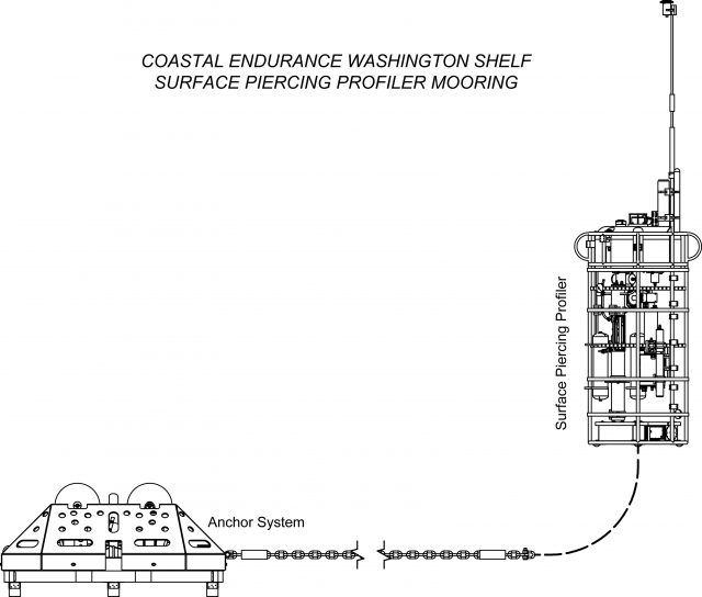
The Endurance Oregon Shelf Surface Piercing Profiler Mooring is located on the Continental Shelf, approximately 80 meters deep. The Continental Shelf-Slope area off the Oregon coast is a highly productive, dynamic upwelling environment. Upwelling brings nutrients to the surface sparking primary production and fueling the food web. In recent years, upwelling has also brought onto the shelf hypoxic, low oxygen, waters that can be harmful to organisms in the area. By sampling in this area, the OOI seeks to gain better insight into upwelling dynamics of this system.
Like other Surface Piercing Profiler Moorings, this mooring contains a Surface Piercing Profiler that allows for the sampling of near surface phenomena as the Profiler travels through the water then breaches the surface. Fine resolution sampling of the water column, particularly at the very surface of the water, provides key insights into the exchange of gases, heat, etc. between the atmosphere and the ocean. While on the surface, the profiler transmits data to shore.
Read MoreCE01ISSM

The Coastal Endurance Oregon Inshore Surface Mooring is located on the inner Continental Shelf, approximately 25 meters deep. The Continental Shelf-Slope area off the Oregon coast is a highly productive, dynamic upwelling environment.
Platform DOI and Citation Guidance
OOI assigns Digital Object Identifiers (DOIs) at the platform or site level. The DOI for the Coastal Endurance Oregon Inshore Surface Mooring is 10.58046/OOI-CE01ISSM.
The minimum recommended citation for this platform is:
NSF Ocean Observatories Initiative. (2014). Coastal Endurance Oregon Inshore Surface Mooring, DOI: 10.58046/OOI-CE01ISSM.
This follows the format NSF Ocean Observatories Initiative. (Year Published). Platform title, DOI: Platform DOI, where Year Published is the year OOI data collection began at the site.
We encourage data users to incorporate full citations when referencing OOI data in order to support FAIR data principles and data traceability. OOI also provides further guidance on citations, including information on adding specific data products and data access points to citations.
Data Access
The following links provide data access via Data Explorer or other methods:
- Direct access to the data on this platform and its subcomponents
- General access to OOI data using a variety of methods
Platform Description
The Coastal Endurance Oregon Inshore Surface Mooring is located on the inner Continental Shelf, approximately 25 meters deep. The Continental Shelf-Slope area off the Oregon coast is a highly productive, dynamic upwelling environment. Upwelling brings nutrients to the surface sparking primary production and fueling the food web. In recent years, upwelling has also brought onto the shelf hypoxic, low oxygen, waters that can be harmful to organisms in the area. By sampling in this area, the OOI seeks to gain better insight into upwelling dynamics of this system.
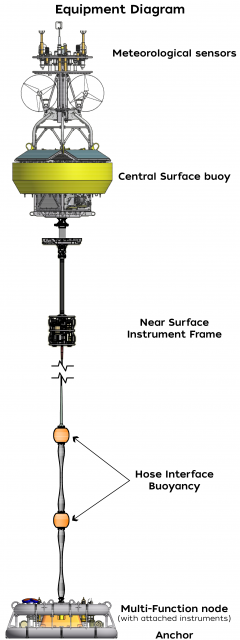
Like other coastal moorings, the Coastal Endurance Oregon Inshore Surface Mooring is specifically designed to examine coastal-scale phenomena and withstand the challenging conditions of shallow coastal environments, including large tidal fluctuations. The Surface Mooring contains instruments attached to a Surface Buoy floating on the sea surface, Near Surface Instrument Frame 7 meters below the surface, and a Seafloor Multi-Function Node (MFN) located on the seafloor. The Surface Buoy provides a platform on which to secure surface instruments above the sea surface, below the sea surface, and across the interface between. Additionally the Surface Buoy contains an antenna to transmit data to shore via satellite.
Read MoreRS01SLBS
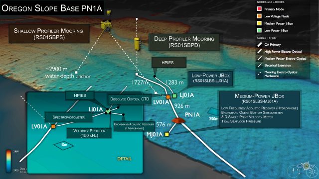
The Oregon Slope Base Seafloor platform is located adjacent to the continental slope off the coast of Oregon at a water depth of ~2,900 meters. The site contains a Medium-Power JBox (MJ01A) and a Low-Power JBox (LJ01A).
Platform DOI and Citation Guidance
OOI assigns Digital Object Identifiers (DOIs) at the platform level. The DOI for the Oregon Slope Base Seafloor is 10.58046/OOI-RS01SLBS.
The minimum recommended citation for this platform is:
NSF Ocean Observatories Initiative. (2014). Oregon Slope Base Seafloor, DOI: 10.58046/OOI-RS01SLBS.
This follows the format NSF Ocean Observatories Initiative. (Year Published). Platform title, DOI: Platform DOI, where Year Published is the year OOI data collection began at the platform.
We encourage data users to incorporate full citations when referencing OOI data in order to support FAIR data principles and data traceability. OOI also provides further guidance on citations, including information on adding specific data products and data access points to citations.
Data Access
The following links provide data access via Data Explorer or other methods:
- Direct access to the data on this platform and its subcomponents
- General access to OOI data using a variety of methods
Platform Description
The Oregon Slope Base Seafloor site is located adjacent to the continental slope off the coast of Oregon at a water depth of ~2,900 meters. The site contains a Medium-Power JBox (MJ01A) and a Low-Power JBox (LJ01A). Here, ocean water properties are profoundly impacted by the California Current, and perhaps internal waves. The coastal region of the Pacific Northwest is a classic wind-driven upwelling system where nutrient-rich deep waters rise to replace warmer surface waters. The result is a large increase in marine productivity that ranges from phytoplankton to fish to marine mammals. Near bottom fauna are periodically negatively impacted by the flow of deep waters with very low oxygen concentrations (hypoxia events), and upwelling of corrosive, acidified waters onto the continental shelf. This area is also just outboard of the Cascadia Subduction Zone, which experienced a >9M earthquake January 26, 1700 and which is now characterized by episodic tremors (slow earthquakes).
As with other JBoxes, these rests on the seafloor, contain geophysical and near seafloor water column instrumentation, and are attached to a fiber-optic cable. The fiber-optic cable provides the JBoxes with a significant power and 1 Gb communication bandwidth that provides two-way communication to instruments for their operation and transmission of data to shore. This seafloor site is also co-located with a Deep and Shallow Profiler Mooring, that collect complementary water column data.
When coupled with other Cabled Array and Endurance Array installations off the central Oregon coast, the Slope Base infrastructure provides a wide variety of opportunities for observing seismic and coastal phenomena, including cross-shelf and along-shelf variability.
Read MoreCP03ISSM
The Coastal Pioneer New England Shelf Inshore Surface Mooring is located on the inner Continental Shelf, approximately 90 meters deep. The Continental Shelf-Slope area off the New England coast is a highly productive area and one that is located at a dynamic intersection where ocean currents meet in weather-like “fronts,” and where nutrients, pollutants, and other properties are exchanged between the coast and the deep ocean.
Platform DOI and Citation Guidance
OOI assigns Digital Object Identifiers (DOIs) at the platform or site level. The DOI for the Coastal Pioneer New England Shelf Inshore Surface Mooring is 10.58046/OOI-CP03ISSM.
The minimum recommended citation for this platform is:
NSF Ocean Observatories Initiative. (2014). Coastal Pioneer New England Shelf Inshore Surface Mooring, DOI: 10.58046/OOI-CP03ISSM.
This follows the format NSF Ocean Observatories Initiative. (Year Published). Platform title, DOI: Platform DOI, where Year Published is the year OOI data collection began at the site.
We encourage data users to incorporate full citations when referencing OOI data in order to support FAIR data principles and data traceability. OOI also provides further guidance on citations, including information on adding specific data products and data access points to citations.
Data Access
The following links provide data access via Data Explorer or other methods:
- Direct access to the data on this platform and its subcomponents
- General access to OOI data using a variety of methods
Platform Description
The Pioneer NES Inshore Surface Mooring is located on the inner Continental Shelf, approximately 90 meters deep. The Continental Shelf-Slope area off the New England coast is a highly productive area and one that is located at a dynamic intersection where ocean currents meet in weather-like “fronts,” and where nutrients, pollutants, and other properties are exchanged between the coast and the deep ocean. Data from the inshore, shelf area help to examine exchanges between the shelf and slope and the shelf ecosystem, as well as provide broader insight into the issues of air-sea gas exchange, including Carbon Dioxide.
Like other Coastal Surface Moorings, the Pioneer NES Inshore Surface Mooring is specifically designed to examine coastal-scale phenomena and withstand the challenging conditions of shallow coastal environments, including large tidal fluctuations. The Surface Mooring contains instruments attached to a Surface Buoy floating on the sea surface, Near Surface Instrument Frame 7 meters below the surface, and a Seafloor Multi-Function Node (MFN) located on the seafloor. The Surface Buoy provides a platform on which to secure surface instruments above the sea surface, below the sea surface, and across the interface between. Additionally the Surface Buoy contains an antenna to transmit data to shore via satellite.
Read MoreCE01ISSP

The Coastal Endurance Oregon Inshore Surface Piercing Profiler Mooring is located on the inner Continental Shelf, approximately 25 meters deep. The Continental Shelf-Slope area off the Oregon coast is a highly productive, dynamic upwelling environment.
Platform DOI and Citation Guidance
OOI assigns Digital Object Identifiers (DOIs) at the platform or site level. The DOI for the Coastal Endurance Oregon Inshore Surface Piercing Profiler Mooring is 10.58046/OOI-CE01ISSP.
The minimum recommended citation for this platform is:
NSF Ocean Observatories Initiative. (2014). Coastal Endurance Oregon Inshore Surface Piercing Profiler Mooring, DOI: 10.58046/OOI-CE01ISSP.
This follows the format NSF Ocean Observatories Initiative. (Year Published). Platform title, DOI: Platform DOI, where Year Published is the year OOI data collection began at the site.
We encourage data users to incorporate full citations when referencing OOI data in order to support FAIR data principles and data traceability. OOI also provides further guidance on citations, including information on adding specific data products and data access points to citations.
Data Access
The following links provide data access via Data Explorer or other methods:
- Direct access to the data on this platform and its subcomponents
- General access to OOI data using a variety of methods
Platform Description
The Coastal Endurance Oregon Inshore Surface Piercing Profiler Mooring is located on the inner Continental Shelf, approximately 25 meters deep. The Continental Shelf-Slope area off the Oregon coast is a highly productive, dynamic upwelling environment. Upwelling brings nutrients to the surface sparking primary production and fueling the food web. In recent years, upwelling has also brought onto the shelf hypoxic, low oxygen, waters that can be harmful to organisms in the area. By sampling in this area, the OOI seeks to gain better insight into upwelling dynamics of this system.
Like other Surface Piercing Profiler Moorings, this mooring contains a Surface Piercing Profiler that allows for the sampling of near surface phenomena as the Profiler travels through the water then breaches the surface. Fine resolution sampling of the water column, particularly at the very surface of the water, provides key insights into the exchange of gases, heat, etc. between the atmosphere and the ocean. While on the surface, the profiler transmits data to shore.
Read MoreCE02SHBP
The Oregon Shelf Cabled Benthic Experiment Package (BEP) is located on the Continental Shelf, approximately 80 meters deep. The Continental Shelf-Slope area off the Oregon coast is a highly productive, dynamic upwelling environment.
Platform DOI and Citation Guidance
OOI assigns Digital Object Identifiers (DOIs) at the platform or site level. The DOI for the Oregon Shelf Cabled Benthic Experiment Package is 10.58046/OOI-CE02SHBP.
The minimum recommended citation for this platform is:
NSF Ocean Observatories Initiative. (2014). Oregon Shelf Cabled Benthic Experiment Package, DOI: 10.58046/OOI-CE02SHBP.
This follows the format NSF Ocean Observatories Initiative. (Year Published). Platform title, DOI: Platform DOI, where Year Published is the year OOI data collection began at the site.
We encourage data users to incorporate full citations when referencing OOI data in order to support FAIR data principles and data traceability. OOI also provides further guidance on citations, including information on adding specific data products and data access points to citations.
Data Access
The following links provide data access via Data Explorer or other methods:
- Direct access to the data on this platform and its subcomponents
- General access to OOI data using a variety of methods
Platform Description
The Oregon Shelf Cabled BEP is located on the Continental Shelf, approximately 80 meters deep. The Continental Shelf-Slope area off the Oregon coast is a highly productive, dynamic upwelling environment. Upwelling brings nutrients to the surface sparking primary production and fueling the food web. In recent years, upwelling has also brought onto the shelf hypoxic, low oxygen, waters that can be harmful to organisms in the area. By sampling in this area, the OOI seeks to gain better insight into upwelling dynamics of this system.
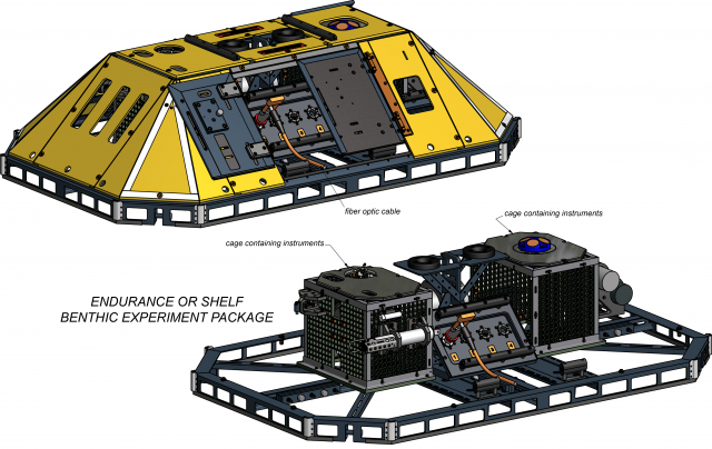
Like other BEPs the Oregon Shelf Cabled BEP is connected to and draws energy from Fiber Optic Cables to power its instruments and to transmit data from the instruments back to shore. Within the yellow protective armor of the BEP are two cages containing instruments that measure various properties of the bottom water.
The Cabled Endurance Oregon Shelf Cabled BEP is located near the base of a surface mooring and surface-piercing profiler mooring, providing complementary seafloor data to the air-sea and water column data collected by the moorings, allowing for the sampling of a full picture of shelf dynamics.
Read More