Long-Term Monitoring of Gas Emissions at Southern Hydrate Ridge
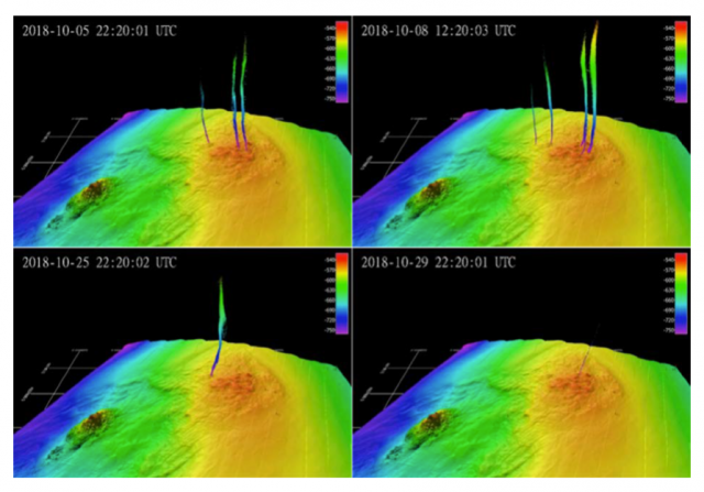
Identifying the parameters that control or influence seabed methane release is important to refining understanding of the carbon cycle. Data from the Regional Cabled Array are providing time-series required to quantify the flux of methane from the seafloor.
Read MoreFacilitating Observatory-Based Subseafloor Science
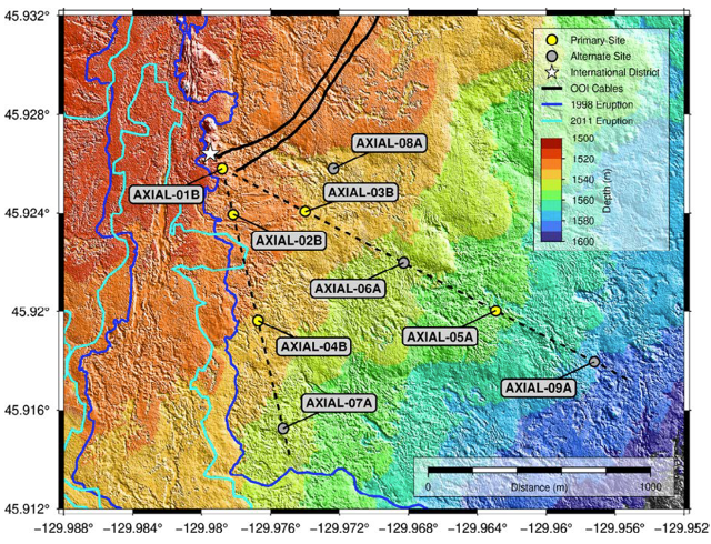
Data flowing from the Regional Cabled Array forms an unparalleled foundation to understand the relationships between microbial, hydrological, geochemical, and geophysical processes in active oceanic crust. Proposed Axial drilling will provide a unique opportunity to determine the nature of subseafloor hydrological properties and develop a 3-D understanding of subseafloor processes in unsedimented crust.
Read MoreForecasting Hypoxia to Support the Dungeness Crab Fishery
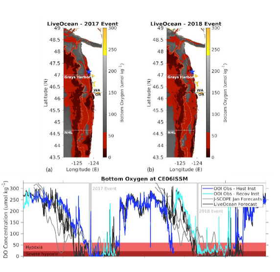
Hypoxia is regularly experienced in Washington and Oregon waters and has been linked to mass mortality events of hypoxia-intolerant species, including the valuable Dungeness crab. The Coastal Endurance Array is aiding the development of a hypoxia forecasting system in this region.
Read MoreIdentifying Impacts of Ocean Acidification and Hypoxia
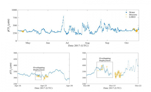
Ocean acidification has emerged as a leading threat to marine ecosystems, and the fisheries and shellfish growers that depend on a productive and vibrant ocean. The Coastal Endurance Array in the Pacific Northwest array is situated in an epicenter for early impacts from the co-occurrence of ocean acidification and hypoxia.
Read MoreMarine Heatwaves
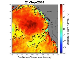
The Coastal Endurance, the Regional Cabled, and the Global Station Papa Arrays were key in identifying and monitoring the approach of a marine heatwave known as the “Blob” and its links to multiple ecosystem impacts on the US west coast.
Read MoreNew View of Biological Carbon Pump
The ocean’s biological carbon pump plays an important role in the global carbon cycle. Using OOI data from the Global Irminger Sea Array, researchers discovered that much of the organic carbon exported from the surface is ventilated back to the atmosphere, rather than being sequestered long-term as had been previously thought.
Read MoreParticle Trajectories in an Eastern Boundary Current
Adapted and condensed by OOI from Wong-Ala et al., 2022, doi:/10.1016/j.jmarsys.2022.103757
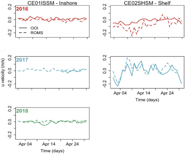
To study the transport and dispersal of marine organisms during spawning, Wong-Ala* et al. developed and applied a Lagrangian particle tracking (LPT) model to compare and contrast particle drift patterns during the spring transition off the Oregon coast. They studied the Oregon coast as it has distinct upwelling and downwelling regimes and variable shelf width. They contrasted years (2016–18) using Regional Ocean Modeling System (ROMS) with different horizontal spatial resolutions (2 km, 250 m). They found the finer spatial resolution model significantly increased retention along the Oregon coast. Particles in the 250 m ROMS were advected to depth at specific times and locations for each simulated year, coinciding with the location and timing of a strong and shallow alongshore undercurrent that is not present in the 2 km ROMS. Additionally, ageostrophic dynamics close to shore, in the bottom boundary layer, and around headlands not present in the coarser model emerged in the 250 m resolution model. They concluded that the higher horizontal model resolution and bathymetry generated well-resolved mesoscale and submesoscale features (e.g., surface, subsurface, and nearshore jet) that vary annually. These results have implications for modeling the dispersal, growth, and development of coastal organisms with dispersing early life stages.
[media-caption path="/wp-content/uploads/2022/11/Endurance-Highlight.png" link="#"]Figure 1: (Fig 9 from Wong-Ala et al. (2022). Comparison of u-velocity (zonal velocity) data between the 250 m ROMS and an inshore mooring and shelf mooring off the Oregon coast collecting data at seven meters depth. The panel is organized by year: 2016 (row 1), 2017 (row 2), 2018 (row 3), and location of data collection: inshore (column 1) and shelf (column 2). In April 2018, there are no data available from the shelf mooring ADCP.[/media-caption]The model applied by Wong-Ala assimilates satellite sea surface temperature and along-track altimetry. Model atmospheric forcing is from the NOAA North American Mesoscale Model (NAM). To validate their model, Wong-Ala et al., used OOI Endurance Array time series data from 2016 to 2018 from the Oregon inshore and shelf moorings (CE01ISSM and CE02SHSM). They compared available OOI zonal and meridional velocities, temperature, and salinity to model output of these parameters for the month of April in each year when they ran their model (Figure 1). They found the modeled currents and temperature from the 250 m ROMS model closely follow the observed data from inshore and shelf moorings compared to the 2 km ROMS. The 250 m ROMS modeled currents and observed currents at the inshore mooring are similar for all three years (Figure 1).
They also found that the 250 m ROMS modeled temperature and observed data are similar in 2017 at the inshore and shelf location. In April 2017 and 2018, the modeled temperature from the 250 m ROMS is about 1 °C cooler than the observed temperatures.
_____________________
*Wong-Ala is a PhD student at Oregon State University. She is a Pacific Islander.
Reference:A. T. K. Wong-Ala, Ciannelli, L., Durski, S. M., and Spitz, Y., Particle trajectories in an eastern boundary current using a regional ocean model at two horizontal resolutions, Journal of Marine Systems, vol. 233, p. 103757, 2022. https://doi.org/10.1016/j.jmarsys.2022.103757.
Read MoreVisions’22: Changing Students Lives
From Deb Kelley, UW, in OOI Quarterly Report, 2022.
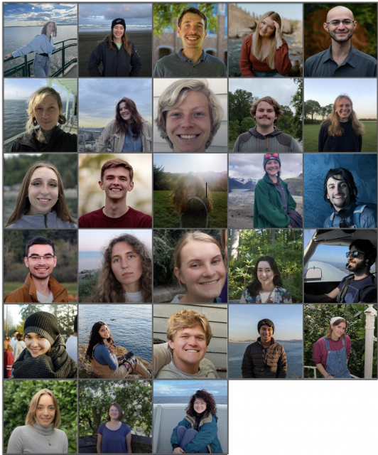
This year, 25 undergraduate students and three graduate students participated on the Regional Cabled Array Operations and Maintenance cruise as part of the VISIONS’22 at-sea experiential learning program. They include students from the US, India, Saudi Arabia, France, and Kazakhstan. They represent a breadth of disciplines spanning Oceanography (11), Engineering (9: Mechanical, Industrial, Bioengineering, Environmental, and Aeronautics and Astronautics), Biology (6: Biology, Marine Biology, and Microbiology), Geology (1), and Policy Studies focused on the United Nations Convention (1). They stood 4 hour-on, 8 hour-off watches in the remotely controlled vehicle, ROPOS control center, learned how to conduct CTD casts and collect and process fluid samples, and worked on deck. Three additional undergraduate student ambassadors, who have participated in past VISIONS’ expeditions (1-3 years), helped mentor the students. All completed cruise blogs on the Interactiveoceans VISIONS’22 Expedition site, and science-engineering and/or engagement projects that will last a quarter to several years. Two students chose projects involving advanced genetic analyses of vent animals and protists for their Senior Thesis in Oceanography. Based on discussions with past students and what they relayed in their blogs, for many this is a life changing experience. Note: two past VISIONS students are now APL engineers as part of the RCA team.
Read More
pH and pCO2 Time Series from the Endurance Array
Adapted and condensed by OOI from Dever et al., 2022, and Fassbender et al., 2018 doi://10.5194/essd-10-1367-2018.
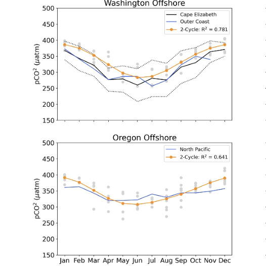
The Ocean Observatories Initiative (OOI) Endurance Array makes extensive measurements of collocated physical and biogeochemical parameters throughout the water column. At the recent Ocean Sciences meeting, we reported on moored measurements from 2015 to the present off Washington and Oregon. We focused on spatial and temporal variability of pH and pCO2 and compared the measurements to published values in the region. This information was also presented in a seminar at UC, Santa Cruz on 14 Jan 2022.
[media-caption path="/wp-content/uploads/2022/04/Endurance-highlight.png" link="#"]OOI (blue, orange) mooring seasonal cycles and monthly averages (gray) for pCO2. For context, OOI mooring cycles are plotted together with Fassbender et al. (2018) (black) regional seasonal cycles. WA moorings are compared with the Fassbender et al. Outer Coast (OC) region. OR moorings are compared with the Fassbender et al. North Pacific (NP) region.[/media-caption]
The quality-controlled biogeochemical time series are self-consistent and in line with other regional measurements. For example, pH and pCO2 have significant onshore-offshore variation and along-shelf differences north and south of the Columbia River. This variability is related to the Columbia River plume, the strength of local upwelling, and mixing with offshore waters. On a seasonal scale, pH and pCO2 is also driven by summer upwelling and winter river inputs. Variability is highest in spring and summer. pCO2 values greatly exceed atmospheric values (~400 μatm) at times in the summer (Figure above). The highest monthly pCO2 averages are seen at the Oregon shelf site.
Dever et al. (2022), pH and pC02 Time Series from the Ocean Observatories Initiative Endurance Array, CBP05, presented at Ocean Sciences Meeting 2022, Honolulu, HI (virtual), 01 Mar 2022.
Fassbender et al. (2018), Earth Syst. Sci. Data, 10, 1367–1401, 2018 https://doi.org/10.5194/essd-10-1367-2018.
Read More
Summer 2021 Low Oxygen Event on the West Coast of North America
Adapted and condensed by OOI from Tetjana et al., 2022.
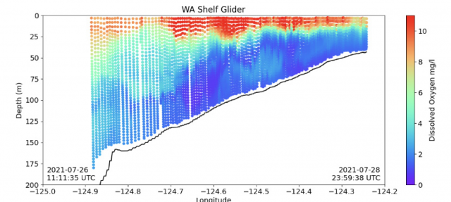
A team of researchers using OOI Coastal Endurance data reported a low oxygen event on the west coast of America. They found that while hypoxic events are known to occur seasonally in coastal bottom waters along the west coast of North America, 2021 was more severely hypoxic. The onset of low oxygen water was the earliest in 35 years (NOAA, 2021), lasted longer (Lundeberg, 2021), was anomalously low, and covered a larger extent, reaching north into Canadian waters where hypoxia is rare (Crawford and Pe.a, 2013).
[media-caption path="/wp-content/uploads/2022/04/Screen-Shot-2022-04-12-at-3.44.04-PM.png" link="#"]Dissolved oxygen measured from an underwater vehicle glider operated by Oregon State University on a cross-shore transect off Grays Harbor, Washington, USA (plots available at http://nvs.nanoos.org and data available at the U.S. Integrated Ocean Observing System Glider Data Acquisition Center, http://gliders.ioos.us ). Hypoxic water occupies the lower three-quarters of the water column near the mid-shelf mooring location (~80 m isobath) and stretches from the outer continental shelf, shoreward to at least the 50-m isobath.[/media-caption]
The paper was published in the Winter 2022 edition of Pices Press and can be reviewed here.

