
Posts Tagged ‘Al Plueddemann’
Watch Pioneer Relocation Update
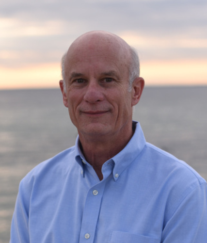
Dr. Albert Plueddemann, senior scientist with Woods Hole Oceanographic Institution and principal investigator for the Coastal and Global Scale Nodes of the Ocean Observatories Initiative (OOI), was the featured speaker at the April 2023 “Science on the Sound” Lecture Series at the Coastal Studies Institute on the ECU Outer Banks Campus. Dr. Plueddemann presented information on an exciting new research ocean observing array headed to the offshore waters of the Outer Banks. Relocation of the Ocean Observatories Initiative Pioneer Array happened on April 20. For those who couldn’t attend in person, the presentation can be watched here.
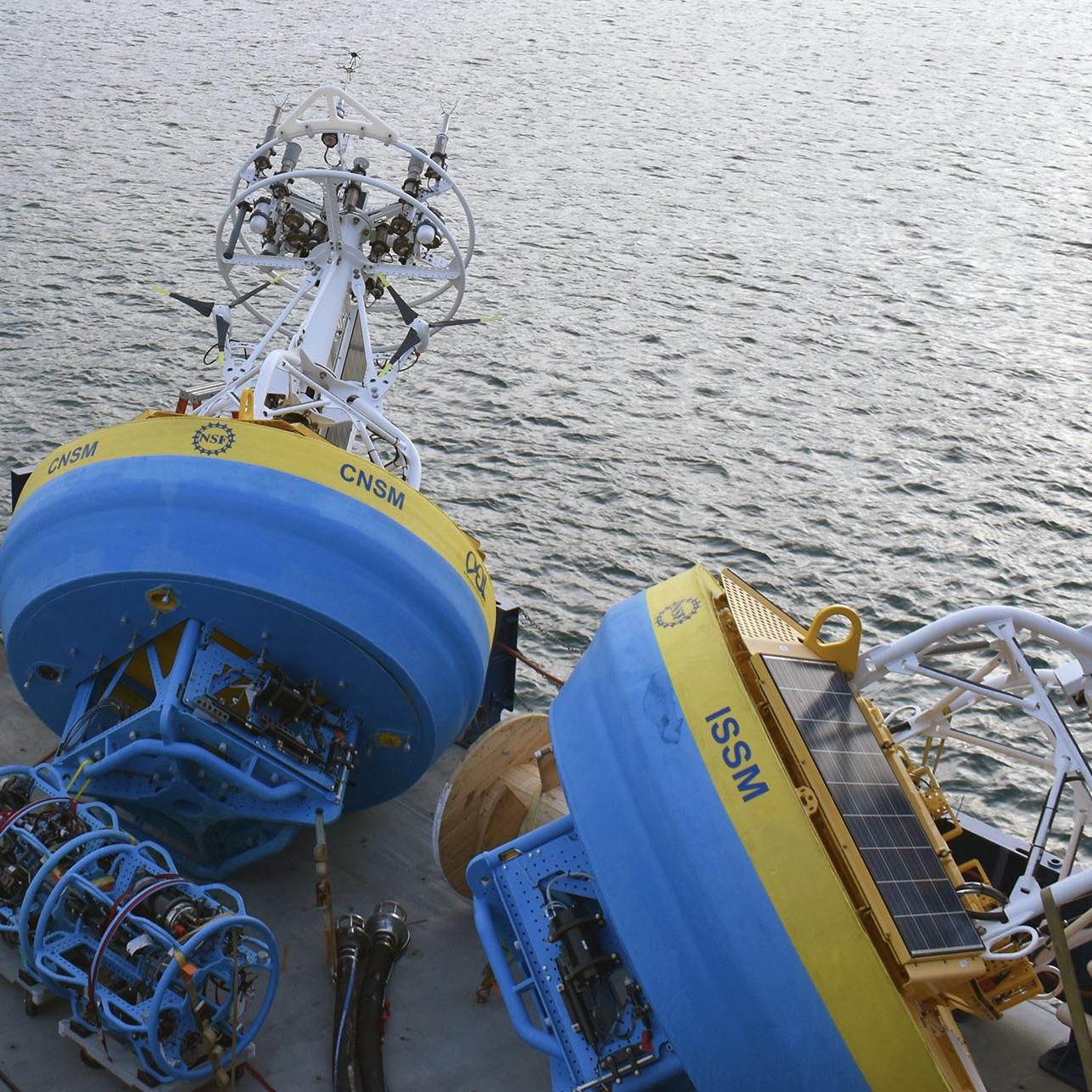
The OOI Pioneer Array was envisioned as a re-locatable coastal array to investigate physical and biochemical exchange processes on the continental shelf and upper slope.The array infrastructure includes moorings, gliders, and AUVs. The Array was previously sited on the New England Shelf (NES), centered at the shelfbreak south of Martha’s Vineyard, MA.
The new MAB site represents a different environment than the New England Shelf location and offers opportunities to collect data on a variety of cross-disciplinary science topics, including cross-shelf exchange and Gulf Stream influences, land-sea interactions associated with large estuarine systems, a highly productive ecosystem with major fisheries, processes driving biogeochemical cycling and transport, and fresh-water outflows during extreme rain events.
Watch the presentation here.
Recovery of Pioneer Array in November
On November 9, 2022, a team of 18 scientists and engineers will leave the dock at Woods Hole, MA aboard the R/V Neil Armstrong on an historic expedition. It will be the nineteenth, and last, expedition to the Coastal Pioneer Array on the New England Shelf (NES). This is because the team will be recovering, but not redeploying the NES Pioneer array as in prior years. Designed to be relocatable, the array will be moved to a new location in theSouthern Mid-Atlantic Bight in early 2024. The ocean observing data collected since 2016 at the NES site, about 75 nautical miles south of Martha’s Vineyard, has provided valuable insights into changing ocean conditions at the Atlantic continental shelf and upper slope. The New England Shelf Pioneer data will remain available to the community for continued analysis.
“The Coastal Pioneer Array has been a true workhorse, providing valuable, consistent data from this important intersection in the ocean, where ocean currents meet in weather-like “fronts,” and where heat, salt, nutrients, and other properties are exchanged between the coast and the deep ocean “said Chief Scientist John Lund, who has been on 18 of Pioneer’s 19 expeditions.
“The impacts of the Coastal Pioneer Array have been many,” added Al Plueddemann, Principal Investigator of OOI Coastal and Global Scale Nodes. “To my knowledge, OOI Pioneer is the first sustained, interdisciplinary shelfbreak observatory. Pioneer data have allowed researchers to identify new shelf-slope dynamics and exchange mechanisms and have given us a first glimpse of what appears to be a changing coastal regime. It is very gratifying to see these outcomes, and to recognize the promise of continued findings using the data for years to come.”
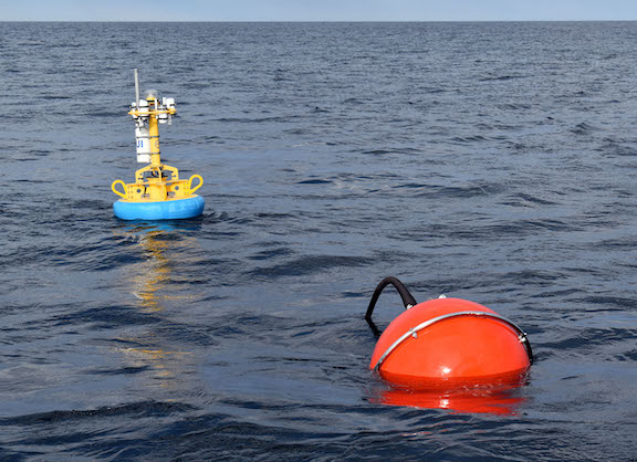
[media-caption path="/wp-content/uploads/2022/11/last_NES_CPM_PMUI-17.jpg" link="#"]This Coastal Profiler Mooring, PMUI-17, was the last Pioneer mooring deployed on the New England Shelf. After providing data through the summer and early fall, it will be recovered in November 2022 and relocated to the Southern Mid-Atlantic Bight in 2024. Credit: Al Plueddemann ©WHOI.[/media-caption]
The Pioneer 19 expedition will be conducted in two legs. The Armstrong will leave port with a nearly empty back deck to allow for carrying back the various parts of the array. During the expedition, three coastal surface moorings, five coastal profiler moorings four coastal gliders, and two global test gliders will be recovered. Additionally, Autonomous Underwater Vehicle (AUV) operations will be conducted in the vicinity of the moored array, as well as CTD (conductivity, temperature, and depth) casts and water sampling at the mooring, AUV, and glider recovery sites. To take full advantage of the time at sea, comparisons of ship and buoy meteorological measurements at the surface mooring sites will be made.
To carry on the collaborative nature of the Pioneer expeditions, during leg 1, the Pioneer Team will be joined by a marine mammal observer from the National Oceanic and Atmospheric Administration and a graduate student from Woods Hole Oceanographic Institution who will be measuring frontal systems, using the shipboard acoustic doppler current profiler and thermosalinograph. Leg 1 will also include a special deployment of a mini-boat surface drifter for an Educational Passages program. This mini-boat was built by students at Waterford School in Connecticut will coincide with the deployment of a similar boat built by students in Ireland.
Leg 2 will include investigators from the New England Shelf Long Term Ecological Research (NES-LTER) Program, who will be conducting underway sampling, and CTD and zooplankton net casts at LTER sites.
An intern from the Marine Advanced Technology Education (MATE) Center will be onboard during both legs.
“While we are all a bit nostalgic about this being the last journey to the Pioneer Array in this location, we are excited about the new science questions that will be answered by the array in its new location.” said Chief Scientist Lund. “We are proud to have been part of collecting nearly a decade’s worth of measurements, which are being used to better understand coastal processes in general with an emphasis on this important New England ocean region.”
Read More
Fishers and OOI Scientists Working Together to Advance Science

An article in the Cape Cod Commercial Fishermen’s Alliance newsletter highlighted the work between its members and scientists at Woods Hole Oceanographic Institution (WHOI), using OOI Pioneer Array data. The collaboration resulted in discovery of …“ all these things happening on the New England Shelf that we didn’t anticipate,” said Al Plueddemann, a senior scientist in physical oceanography at WHOI.
An important change in recent years is an increase in the meandering or “wiggliness” of the Gulf Stream. In addition the Gulf Stream has been generating more “Warm Core Rings,” large clockwise eddies.
Read more about how the collaboration is advancing science here.
Sweet 16: Pioneer Array Successfully Turned
Twenty days at sea. Forty different at-sea operations. Nine moorings recovered. Eight moorings, two coastal profiling gliders and two global test gliders deployed. Completion of more than 25 objectives during the 16th turn of the Coastal Pioneer Array.
By all counts, the Pioneer Array 16 expedition was a huge success. The scientific team was able to accomplish a full mooring service cruise in spite of COVID-imposed restrictions that restricted building occupancy for pre-cruise preparation, limited personnel onboard to accomplish the work and imposed a two-week quarantine period prior to boarding the ship.
“It’s always takes a focused effort from many people for a successful cruise, but COVID has made it harder.” said Al Plueddemann, chief scientist for Pioneer Array and principal investigator for the Ocean Observatory Initiative’s (OOI) Coastal and Global Scale Nodes. “The OOI team, the captain and crew of the Armstrong, and the shore-side support all put in a great effort to see this through to completion, while still operating at reduced efficiency under ongoing COVID-19 restrictions.”
A variety of atmospheric and oceanographic measurements are made prior to deployments and following recoveries for validation of mooring, glider, and AUV (autonomous underwater vehicle) observations. The team also conducted cross-shelf and along-shelf CTD surveys and collected water samples adjacent to all the moorings. The team also surveyed the array’s region using shipboard sensors (ADCP, EK-80, and thermosalinograph).
In addition to the successful mooring operations, the Pioneer 16 team completed several mobile platform objectives as well. For the spring and summer time period, two coastal profiling gliders were deployed to replace winter profiler moorings. Two global test gliders were also put through their paces to ensure safe operation and reliable data delivery prior to operations at a global array. Two AUVs were launched and traveled pre-determined paths around the array before being recovered and having their data downloaded. While the team was following the AUVs to ensure the missions were progressing as planned, they encountered a pod of about 40 pilot whales that included both young and adult whales. The team and the pod of whales were equally fascinated by each other. Both groups stopped to observe the other’s behaviors.
[caption id="attachment_20931" align="alignleft" width="300"]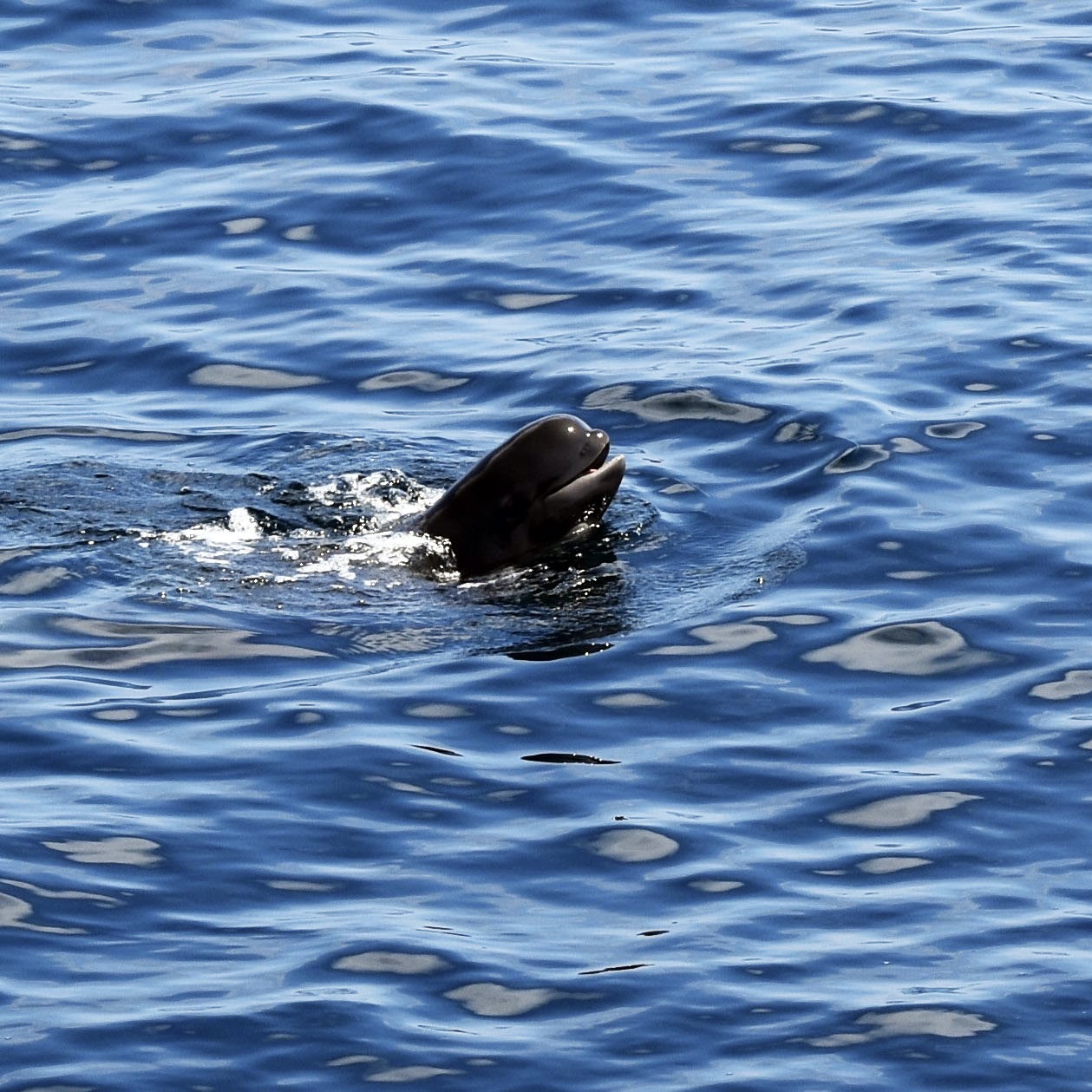 Photo: Rebecca Travis©WHOI.[/caption]
“The data we collect are helping scientists better understand the ocean environment and how it is changing. Seeing the pilot whales reminded us of the importance of these observations, and the research they enable, to the marine ecosystem.” added Plueddemann.
Read More
Pioneer Array Design: Building on the known to explore the unknown
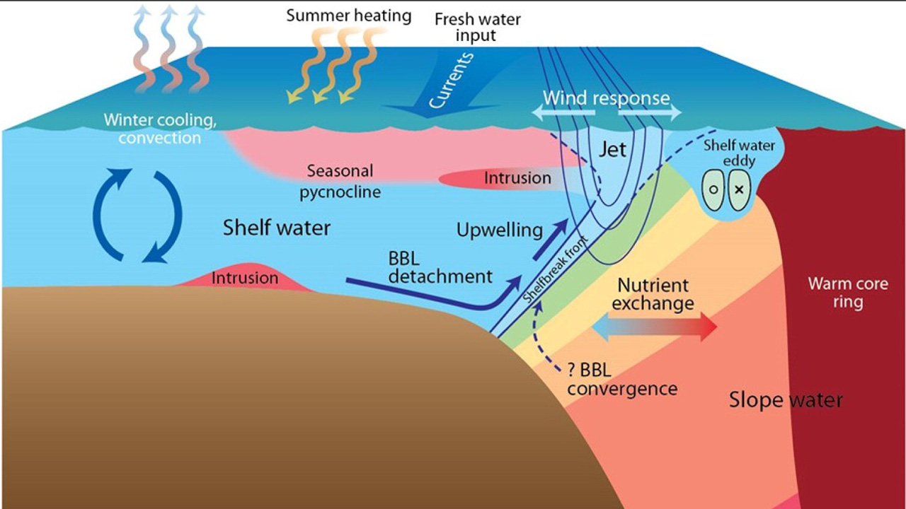
The location of the Ocean Observatories Initiative Pioneer Array has been ideal for understanding recent, unprecedented changes in temperature and ocean properties on the continental shelf and slope off the coast of New England, coincident with an increase in warm core rings at a time when the Gulf Stream has grown increasingly unstable. That’s the conclusion of a review paper published last month in the Journal of Operational Oceanography.
The paper, written by Glen Gawarkiewicz and Al Plueddemann of Woods Hole Oceanographic Institution, details how the components and location of the array were determined and how the data gathered there has changed scientific questions being asked in this critical region. The array also provides a unique observatory model that can be applied in other shelf break regions across the world.
“We already knew a fair bit about what was happening in the region, but what we’re seeing now isn’t what we expected,” said Plueddemann. “Fortunately, the array was designed and constructed in such a way that we were ready for just about anything.”
The shelf break front stretches along the U.S. Northeast Coast from Georges Bank to Cape Hatteras, dividing cooler, fresher waters of the coast and continental shelf from warm, saltier waters of the slope. It is a complex, productive, and constantly changing area, driven by the interaction of winds, currents, and offshore rings.
Prior to the Pioneer Array, data from the shelf break came primarily from stationary moored instruments or from short-term, mobile observations provided by ocean gliders and towed shipboard systems. In designing the Pioneer Array, scientists and engineers working with the NSF-funded Ocean Observatories Initiative integrated moorings, gliders and propeller-driven AUVs to provide a long-term, multi-dimensional data set that blends the advantages of multiple observing technologies. This is particularly important as ocean processes occurring at the shelf break occur on a variety of space and time scales.
Gawarkiewicz and Plueddemann point out that in addition to enabling new scientific discovery, data from the Pioneer Array has the potential for real-time applications to help track and forecast hurricanes and winter storms, improve search-and-rescue operations, and the siting and operation of off-shore wind installations.
Since becoming operational in 2016, the Pioneer Array has gathered near-continuous data across a 24,000 square-kilometer swath of the shelf break region. By combining moorings, gliders, and AUVs, the array has provided the scientific community with high-resolution observations across space and time, which are unprecedented in their scope and detail and are also freely available on the Ocean Observatories Initiative data portal.
“We haven’t even scratched the surface yet,” said Plueddemann. “There’s still lots of potential to mine in the Pioneer Array data.”
The Ocean Observatories Initiative (OOI) is a long-term infrastructure project funded by the National Science Foundation to gather physical, chemical, and biological data from the ocean, atmosphere, and seafloor and to deliver that data on demand and in near real-time online. The program includes fixed instruments and autonomous underwater vehicles deployed at key locations off in U.S. coastal waters and in the open ocean. The OOI currently maintains arrays off the Northeast and Northwest coasts of the U.S., the Irminger Sea southeast of Greenland, and at Station Papa in the Gulf of Alaska, as well as a seafloor cabled array off the coast of Oregon. Data from the arrays help researchers address questions ranging from rapidly changing weather events to long-term climate change and from air-sea interaction to sea floor processes. OOI is managed by the Woods Hole Oceanographic Institution (WHOI) and implemented by WHOI, the University of Washington, Oregon State University, and Rutgers, the State University of New Jersey.
Read More