
Posts Tagged ‘AUV’
Successful Underwater Surveys in the Mid-Atlantic Bight: OOI Team Deploys REMUS AUVs for Coastal Ocean Monitoring
Taking advantage of a period of calm weather, OOI staff successfully completed underwater surveys of the Pioneer Mid-Atlantic Bight (MAB) shelf and upper slope using OOI REMUS AUVs. With ab underway speed of over 3 knots, the AUVs provide synoptic transects of rapidly changing coastal systems – analogous to repeated “snapshots” of the ocean physical, biological, and nutrient conditions across the shelf capturing changes that occur over short time and spatial scales (meters to kilometers, and hours to one day).
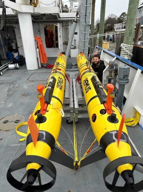
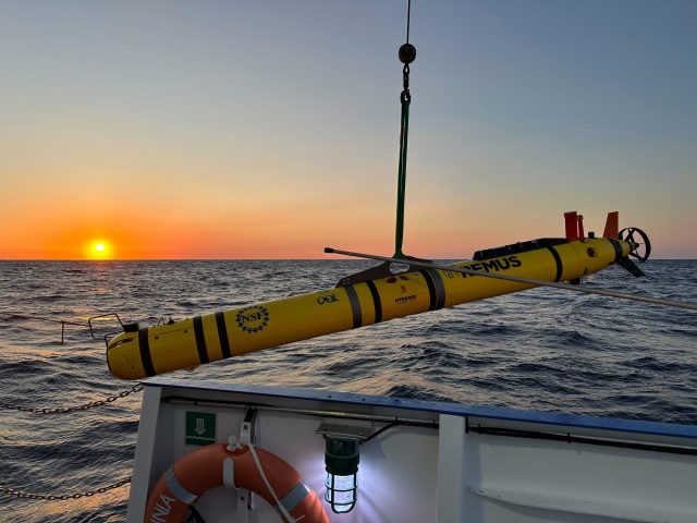
The OOI Pioneer array was relocated from the New England Shelf (NES) to the southern Mid-Atlantic Bight in April 2024. AUV surveys previously conducted in the continental shelf waters offshore of New England now take place offshore of the sandy Outer Banks of North Carolina in a new and highly dynamic part of the US continental shelf. Moving the Pioneer Array to the MAB naturally resulted in some changes to operations, foremost being the use of new vessels (for this cruise, the R/V Virginia operated by the Virginia Institute of Marine Science). For efficiency, the AUVs are shipped fully assembled inside a 20 ft shipping container, along with all communications, control, and deck equipment. On arrival everything can be hoisted aboard and prepared for sea without needing re-integration that consumes valuable days on shore (Fig 1). The ships crane was modified by WHOI engineer Jared Schwartz to install the Ship of Opportunity Launch and Recovery System (SOO-LARS), a modular hydraulic winch system that OOI employs for safe and efficient deployment and recovery of these large AUVs on ships of several classes (Fig. 2).
The AUV operations at MAB derive from previous work at Pioneer NES. Once deployed, the AUVs run autonomously and sample in a series of saw-tooth profiles along a pre-programmed track, remaining in acoustic contact with the support vessel and surfacing periodically to update exact location from GPS. These plans were adapted for the MAB to compensate for the larger expanse of shelf traversed and the large changes in water column density between the shallow (25 m) inner shelf and deeper > 500 m upper slope. This is further complicated by density variations along the shelf and seasonally under the triple-influence of estuarine outflows, continental shelf processes, and the Gulf Stream just a few miles beyond the offshore extent of the sampling region (Fig 3). The MAB is also busy with a range of commercial, fishing, and military vessel traffic, offshore fixed installations, and ocean life in every shape and size imaginable. All factors that must be considered in advance and avoided underway by the invisible submerged AUVs. As was true for Pioneer NES, the support and knowledge of local vessel operators is vital to supporting at-sea operations and for meeting OOI’s science mission objectives.
The AUV data were offloaded from the vehicles after recovery. The data are discoverable in the OOI Data Explorer, and also available on the OOI raw data repository, following data format conversion and sensor post-calibration.
In addition to completing two consecutive surveys, each about 24 hours in length, the at-sea team of Andy Robinson, Collin Dobson, and Natalia Moore completed the scheduled recovery of the Offshore Mesoscale glider cp_379 (Fig. 4). A bonus accomplishment of this cruise was cross-training OOI staff new to AUV operations (Moore), made easier by the prevailing mild weather, experienced AUV techs, and the capable ship’s crew.
[gallery columns="2" size="large" ids="35942,35943,35944,35945"]Photo credits: Collin Dobson
Read MoreOOI-CGSN Team Completes First Standalone AUV Cruise at Pioneer MAB Array
The Ocean Observatories Initiative’s (OOI) Coastal and Global Scale Nodes (CGSN) team recently conducted their first standalone small vessel Autonomous Underwater Vehicle (AUV) cruise at the Pioneer Mid-Atlantic Bight (MAB) Array. Aboard the R/V Virginia, team members Andy Robinson, Collin Dobson, and Dan Bogorff successfully completed dock testing of their launch and recovery systems before heading offshore to carry out AUV transects through the array.
The mission utilized two REMUS600 AUVs, equipped with a variety of scientific instruments, including CTDs (conductivity, temperature, depth), fluorometers, dissolved oxygen sensors, nitrate sensors, photosynthetically active radiation (PAR) sensors, and ADCPs (acoustic doppler current profilers). These tools provide essential data for understanding ocean conditions and biogeochemical processes at the Pioneer MAB array.
This accomplishment highlights the OOI-CGSN team’s dedication to advancing autonomous AUV ocean exploration and data-driven research.
[gallery size="full" ids="34951,34952,34953,34954,34955,34956"](c): Collin Dobson
Read MoreAUV Data Available in a Variety of Formats
We recently announced and demonstrated new access to autonomous underwater vehicle (AUV) data through OOI’s Data Explorer. Since the initial announcement, more has been done to provide additional AUV data and improve data delivery. As part of OOI’s efforts towards Findable, Accessible, Interoperable, and Reusable (FAIR) data, not only are AUV data easier to find and access, we now are providing these data in more interoperable and reusable formats.
When you view an AUV Deployment in Data Explorer (FIG 1), data in different formats may be accessed either through the Metadata link in the left panel (FIG 1 A) or the Downloads button (FIG 1 B). The Downloads button provides access to data products, in formats including comma separated variable (CSV), that are derived from Network Common Data Form (NetCDF) files in the OOI Raw Data Repository. To access these NetCDF files, open the Metadata link, navigate into that deployment’s folder, and then into its PROFILES subfolder. Note that each deployment’s folder also contains raw data as collected by the vehicle and an EXPORTED subfolder for data products in Matlab format.
[media-caption path="https://oceanobservatories.org/wp-content/uploads/2024/01/AUV_OOI_newsletter_Fig1_portrait.png" link="#"]Fig. 1 AUV Deployment in Data Explorer. Inset A: Metadata link to Raw Data Repository to access NetCDF format per deployment in PROFILES subfolder. Inset B: Downloads button provides data products in multiple formats. Credits: Screen grab from Data Explorer (https://dataexplorer.oceanobservatories.org/#platform/c646022c-ce04-5be8-8cd8-117da55121fa/v2?pid=14&tab=visualization) and Flaticon. Flaticon license: Free for personal and commercial use with attribution.[/media-caption]The software development effort by OOI’s Coastal & Global Scale Nodes (CGSN) Team to publish AUV data into Data Explorer involved OOI’s Cyberinfrastructure Team and Axiom Data Science. This effort builds on earlier work by OOI’s Coastal Endurance Array Team to publish glider data into the IOOS Glider DAC, and subsequently into OOI’s Data Explorer. The existing code base was integrated into a larger framework supporting the input of either glider or AUV data and supporting output formatting compatible with either or both the Glider DAC or Data Explorer.
CGSN maintains two AUV platforms, which are deployed from shipboard as part of at-sea operations in and around OOI mooring sites. The AUVs conduct ~24 hour transects, consisting of multiple profiles of the water column, before being retrieved by the ship for data collection and maintenance. CGSN AUV platforms are fitted out with a variety of instrumentation including CTD, fluorometer, and sensors for photosynthetically active radiation, dissolved oxygen, dissolved nitrate, and current measurement. When applicable, annotations are provided per deployment per instrument in OOI’s OOINet portal and M2M (Machine to Machine) interface; we plan to incorporate these annotations into NetCDF metadata and ultimately into Data Explorer.
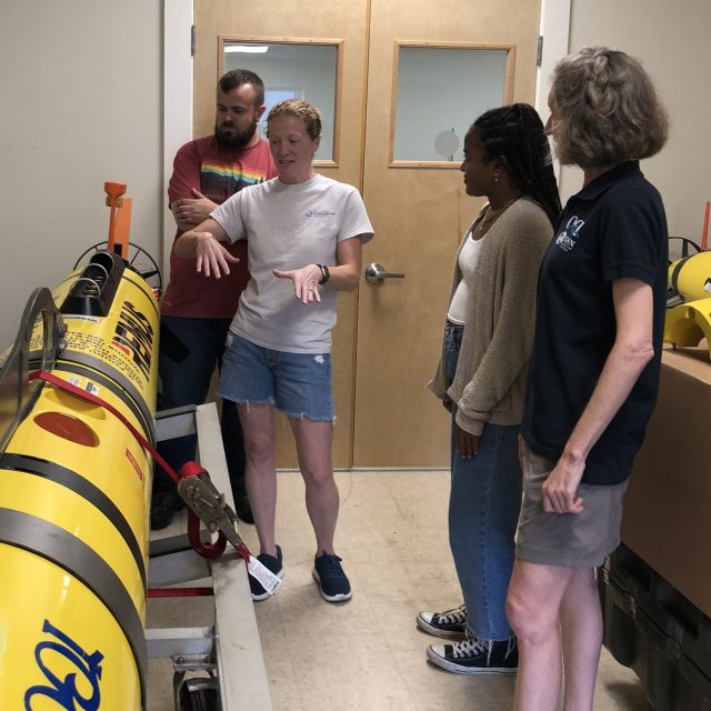
[media-caption path="https://oceanobservatories.org/wp-content/uploads/2024/01/IMG_126519-2.jpg" link="#"]CGSN Team member Diana Wickman (2nd from left) explains how the AUV moves during a deployment, with CGSN Team members Collin Dobson (far left) and Stace Beaulieu (far right) and student researcher Taina Sanchez (2nd from right). Credit: D. Trew Crist © WHOI.[/media-caption]
The Data Explorer provides access to all across-shelf and along-shelf AUV deployments at the Coastal Pioneer NES Array from 2016 to 2022.Future AUV transect data at the Coastal Pioneer MAB Array will also be published through Data Explorer as the data become available. As an example for reusability of these data in newly-available formats, a student examined across-shelf patterns in salinity, chlorophyll, and nitrate as part of Northeast U.S. Shelf Long-Term Ecological Research.
Read More