Posts Tagged ‘Coastal Pioneer MAB’
Successful Underwater Surveys in the Mid-Atlantic Bight: OOI Team Deploys REMUS AUVs for Coastal Ocean Monitoring
Taking advantage of a period of calm weather, OOI staff successfully completed underwater surveys of the Pioneer Mid-Atlantic Bight (MAB) shelf and upper slope using OOI REMUS AUVs. With ab underway speed of over 3 knots, the AUVs provide synoptic transects of rapidly changing coastal systems – analogous to repeated “snapshots” of the ocean physical, biological, and nutrient conditions across the shelf capturing changes that occur over short time and spatial scales (meters to kilometers, and hours to one day).
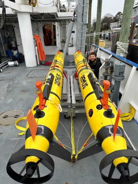
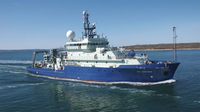
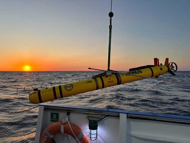
The OOI Pioneer array was relocated from the New England Shelf (NES) to the southern Mid-Atlantic Bight in April 2024. AUV surveys previously conducted in the continental shelf waters offshore of New England now take place offshore of the sandy Outer Banks of North Carolina in a new and highly dynamic part of the US continental shelf. Moving the Pioneer Array to the MAB naturally resulted in some changes to operations, foremost being the use of new vessels (for this cruise, the R/V Virginia operated by the Virginia Institute of Marine Science). For efficiency, the AUVs are shipped fully assembled inside a 20 ft shipping container, along with all communications, control, and deck equipment. On arrival everything can be hoisted aboard and prepared for sea without needing re-integration that consumes valuable days on shore (Fig 1). The ships crane was modified by WHOI engineer Jared Schwartz to install the Ship of Opportunity Launch and Recovery System (SOO-LARS), a modular hydraulic winch system that OOI employs for safe and efficient deployment and recovery of these large AUVs on ships of several classes (Fig. 2).
The AUV operations at MAB derive from previous work at Pioneer NES. Once deployed, the AUVs run autonomously and sample in a series of saw-tooth profiles along a pre-programmed track, remaining in acoustic contact with the support vessel and surfacing periodically to update exact location from GPS. These plans were adapted for the MAB to compensate for the larger expanse of shelf traversed and the large changes in water column density between the shallow (25 m) inner shelf and deeper > 500 m upper slope. This is further complicated by density variations along the shelf and seasonally under the triple-influence of estuarine outflows, continental shelf processes, and the Gulf Stream just a few miles beyond the offshore extent of the sampling region (Fig 3). The MAB is also busy with a range of commercial, fishing, and military vessel traffic, offshore fixed installations, and ocean life in every shape and size imaginable. All factors that must be considered in advance and avoided underway by the invisible submerged AUVs. As was true for Pioneer NES, the support and knowledge of local vessel operators is vital to supporting at-sea operations and for meeting OOI’s science mission objectives.
The AUV data were offloaded from the vehicles after recovery. The data are discoverable in the OOI Data Explorer, and also available on the OOI raw data repository, following data format conversion and sensor post-calibration.
In addition to completing two consecutive surveys, each about 24 hours in length, the at-sea team of Andy Robinson, Collin Dobson, and Natalia Moore completed the scheduled recovery of the Offshore Mesoscale glider cp_379 (Fig. 4). A bonus accomplishment of this cruise was cross-training OOI staff new to AUV operations (Moore), made easier by the prevailing mild weather, experienced AUV techs, and the capable ship’s crew.
[gallery columns="2" size="large" ids="35942,35943,35944,35945"]Photo credits: Collin Dobson
Read MorePioneer 21 Cruise Cancellation
Due to unforeseen circumstances requiring shipyard repairs to the R/V Armstrong, it was not possible to conduct the fall service cruise for the Pioneer MAB Array, originally scheduled for December 2024. All array infrastructure remains in place and data are available via telemetry. The moorings will be refreshed during the spring 2025 cruise, currently scheduled for March 2025. Glider and AUV missions will continue to operate as normal.
Read MoreOOI-CGSN Team Completes First Standalone AUV Cruise at Pioneer MAB Array
The Ocean Observatories Initiative’s (OOI) Coastal and Global Scale Nodes (CGSN) team recently conducted their first standalone small vessel Autonomous Underwater Vehicle (AUV) cruise at the Pioneer Mid-Atlantic Bight (MAB) Array. Aboard the R/V Virginia, team members Andy Robinson, Collin Dobson, and Dan Bogorff successfully completed dock testing of their launch and recovery systems before heading offshore to carry out AUV transects through the array.
The mission utilized two REMUS600 AUVs, equipped with a variety of scientific instruments, including CTDs (conductivity, temperature, depth), fluorometers, dissolved oxygen sensors, nitrate sensors, photosynthetically active radiation (PAR) sensors, and ADCPs (acoustic doppler current profilers). These tools provide essential data for understanding ocean conditions and biogeochemical processes at the Pioneer MAB array.
This accomplishment highlights the OOI-CGSN team’s dedication to advancing autonomous AUV ocean exploration and data-driven research.
[gallery size="full" ids="34951,34952,34953,34954,34955,34956"](c): Collin Dobson
Read MorePioneer MAB Providing Turbidity from OOI Core Fluorometers
OOI is now providing telemetered turbidity measurements from the Coastal Pioneer Mid-Atlantic Bight (MAB) Array using Sea-Bird Scientific ECO triplet-w optical sensors. A test deployment showed that these instruments measured turbidity consistent with co-located turbidity meters that were recommended at the scientific community workshops. The results of the test deployment confirmed that OOI could satisfy the request for turbidity data with re-purposed instruments already in the suite of OOI core sensors. OOI has used ECO triplet-w optical sensors to measure chlorophyll a, CDOM fluorescence, and optical backscatter. This April, ECO triplet sensors were deployed with a secondary calibration from the vendor to convert backscatter channel (700 nm wavelength) measurements to turbidity in Nephelometric Turbidity Units (NTUs).
[media-caption path="https://oceanobservatories.org/wp-content/uploads/2024/05/Screenshot-2024-05-30-at-4.33.23-PM.png" link="#"]Figure 1: Comparison of turbidity recorded during Coastal Pioneer MAB Array At-Sea Test 3 from a Seapoint turbidity meter and a Sea Bird ECO triplet optical sensor. Data shown was recorded in March 2023 at a depth of 35 m.[/media-caption]To conduct the test deployment, turbidity measurements were recorded every 15 or 30 minutes from 1-minute bursts of sampling at 1 sample per second (1 Hz) by both the ECO-triplet and co-located community-recommended turbidity meters. Turbidity in NTUs from the ECO triplet was calculated by applying a vendor-supplied scaling factor to the raw voltage counts minus the dark counts. The requested turbidity meters reported their measurements as a mean of the sample burst measurements, so the mean of each ECO triplet sample burst was computed for comparison. The burst means from ECO triplets were compared with the other turbidity meter measurements at the same location and depths. A time series comparison from 35 m depth during March 2023 showed a mean difference of 0.2 NTU between the two instruments. The standard deviation of the difference at 35 m depth was 1.2 NTU (Fig. 1). The March 2023 comparison at 7 m depth showed a mean difference of 0.1 NTU. The standard deviation of the difference at 7 m depth was 0.06 NTU. Turbidity measurements recorded before and after a CTD cast at the start of the test deployment were also within 0.15 NTUs of the mean turbidity measurements in the surface mixed layer and bottom layer from a rosette-mounted Wet Labs FLNTURTD. The full report on the test deployment, At-Sea Test 3, is available upon request. Based on the results of the test deployment, the OOI Program determined that the ECO triplet-w optical sensors with a secondary calibration could deliver good quality turbidity data.
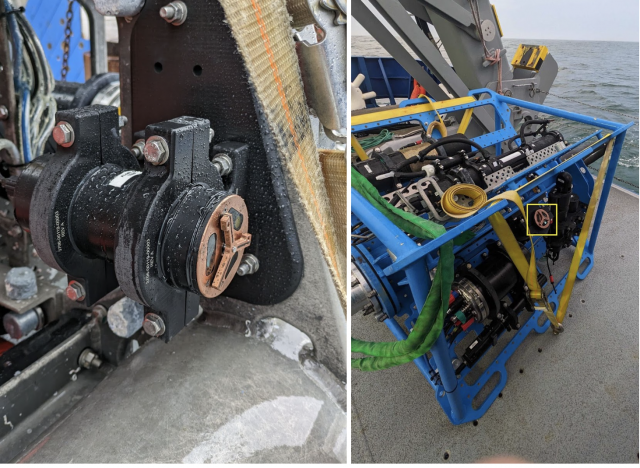
ECO triplet optical sensors deployed as part of the Coastal Pioneer MAB Array now allow OOI to serve turbidity data from all 3 surface moorings at 7 m depth and 1 m above the seafloor. The use of existing OOI core sensors simplified integration into the instrument platforms, since additional ECO triplets only had to be added to seafloor nodes, and it streamlined the process of serving data, since existing sensor processing code could be reworked to provide turbidity data. Turbidity data delivered by OOI include all samples recorded during a sample burst so that data users can apply their preferred aggregation method. Since April, the ECO triplets on the near-surface platforms (Fig. 2, right) have been sampling at 1 Hz for bursts of 3 minutes four times an hour, and on the seafloor nodes (Fig. 2, left) the sensor samples at 1 Hz for 17 minutes once an hour. Data users can view telemetered turbidity data here: Coastal Pioneer MAB Array turbidity on Data Explorer.
[media-caption path="https://oceanobservatories.org/wp-content/uploads/2024/05/Screenshot-2024-05-30-at-4.32.51-PM.png" link="#"]Figure 2: Sea Bird ECO triplet optical sensors that are measuring turbidity are mounted on the Seafloor Multi-Function Node (left) and on the Near-Surface Instrument Frame (right, yellow box) of the Coastal Pioneer MAB Surface Moorings: Northern, Southern, and Central. The copper-covered “Y” is a wiper blade that prevents growth and marine debris from accumulating over the oval sensor windows. Credit: Sawyer Newman © WHOI. [/media-caption]
Read More
Test Deployments Underway for Pioneer Relocation
Tuesday February 21, 2023, a team of scientists and engineers from Woods Hole Oceanographic Institution (WHOI) left Charleston, SC aboard the R/V Neil Armstrong to begin test deployments in preparation for the installation of an Ocean Observatories Initiative (OOI) ocean observing system in its new location in the southern Mid-Atlantic Bight (MAB). The science team will deploy two test moorings off the coast of North Carolina, occupying shallow and deep sites of the proposed array. The deployments will supplement computer modeling to ensure the mooring designs perform as expected in the MAB environment. Once the array is fully operational in 2024, the ocean data collected will be available online in near real-time to anyone with an Internet connection.
Ocean observing data helps to track, predict, manage, and adapt to changes in the marine environment. Coastal communities use ocean observing data to prepare for floods and other natural disasters. The instrumented arrays gather physical, chemical, geological, and biological data from the air-sea interface to the seafloor, providing a wealth of information for research and education.
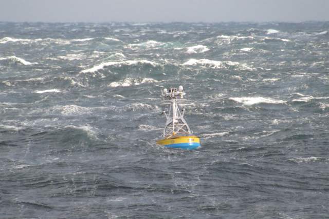
[media-caption path="https://oceanobservatories.org/wp-content/uploads/2023/02/CNSM_buoy_atsea-2-1.png" link="#"]Offshore conditions can be brutal for moorings that remain in the water for six-month deployments. The new location for the OOI’s Coastal Pioneer Array is designed to withstand treacherous conditions, including extreme storms. Credit: ©Woods Hole Oceanographic Institution.[/media-caption]“This new Pioneer Array location in the MAB offers many opportunities for scientists to obtain data to further their research, and will provide better insight into conditions in the area for a variety of stakeholders,“ said Al Plueddemann, Project Scientist for OOI’s Coastal and Global Scale Nodes group at WHOI, which is responsible for operation of the Pioneer Array. “We welcome researchers, educators, and industry members to reach out to us to explore ways we might work together to maximize the usefulness of the data.”
The OOI is funded by the National Science Foundation (NSF) to collect and deliver ocean data in select locations for 25 years or more. This longevity of data collection makes it possible for researchers to identify both short term processes and long-term trends in our changing ocean. The OOI’s Coastal Pioneer Array was designed to be relocatable, and its first deployment was off the coast of New England at the Continental Shelf/Slope interface, where it collected data from 2016 until it was recovered in September 2022. The new location off the coast of North Carolina was chosen by NSF based on input from the science community during a series of NSF-sponsored workshops in 2022.
Dr. Reide Corbett, Executive Director of the Eastern Carolina University’s Coastal Studies Institute (CSI), is enthusiastic about the opportunities the Pioneer Array will bring to the region. “The cross-shelf suite of instrumentation off northeastern North Carolina’s coast is in a region of complex physics and critical ecosystem dynamics that draws interest from many disciplines and creates opportunities for transformational science. This is also in a region with a growing renewable energy sector, including two active offshore wind leases, with opportunities to partner with the agencies involved. The Coastal Studies Institute is excited about the observations that will be made from these instruments, allowing us to better address climate change influences in the coastal ocean, and improve ocean/weather/storm forecasts through data sharing. Beyond just the instruments in the water, the new partnerships and collaborations created as part of this deployment will provide the ability to better engage this socio-economically diverse region, with disadvantaged groups more impacted by sea level rise and climate change compared to many coastal regions. This broad network of partnerships across the region will provide a mechanism to drive knowledge to action,” states Corbett.
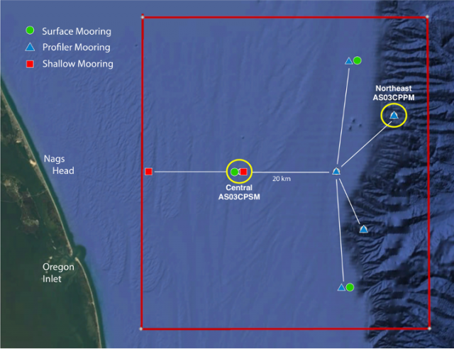
[media-caption path="https://oceanobservatories.org/wp-content/uploads/2023/02/Pioneer-MAB-schematic.png" link="#"]Schematic drawing of the Pioneer MAB moored array to be deployed off the coast of Nags Head, North Carolina. The full array, to be deployed in the spring of 2024, will consist of ten moorings at seven different sites (three sites contain mooring pairs). For the test deployment, one Coastal Surface Mooring will be deployed at the Central site and one Coastal Profiler Mooring will be deployed at the Northeast site.[/media-caption]The new MAB site represents a different environment than the New England Shelf location and offers opportunities to collect data on a variety of cross-disciplinary science topics, including cross-shelf exchange and Gulf Stream influences, land-sea interactions associated with large estuarine systems, a highly productive ecosystem with major fisheries, processes driving biogeochemical cycling and transport, and fresh-water outflows during extreme rain events.
The MAB location is expected to have different wind, wave, and current conditions than the Pioneer Array experienced on the New England Shelf. In addition, deployments in the new location will be in both shallower and deeper water depths than those off the New England coast.
A Coastal Surface Mooring (CSM) will be deployed at 30 meters depth at 35o 57.00’ N, 75o 07.5’ W. The CSM is specifically designed to examine coastal-scale phenomena and withstand the challenging conditions of shallow coastal environments. The Surface Mooring contains instruments attached to a Surface Buoy floating on the sea surface, a Near Surface Instrument Frame 7 meters below the surface, and a Seafloor Multi-Function Node (MFN) located on the seafloor. Additionally, the Surface Buoy contains wind turbines and solar panels for power generation and antennas to transmit data to shore via satellite.
A Coastal Profiler Mooring (CPM) will be deployed at 600 meters depth, 36o 03.80’ N, 74o 44.56’ W. The CPM contains a Wire-Following Profiler that houses instruments. The Wire-Following Profiler moves through the water column along the mooring riser, continuously sampling ocean characteristics from about 23 m below the surface to 23 m above the sea floor. The CPMs also carry an upward-looking Acoustic Doppler Current Profiler to measure ocean currents over the same region of the water column traversed by the profiler.
The test mooring data will be evaluated during the deployment and after recovery to determine whether any modifications are needed to the mooring designs. The plan is to deploy the full array in the spring 2024.
An update on the Pioneer Array relocation is planned for April 20 at 6 pm at the Coastal Studies Institute on East Carolina University’s Outer Banks Campus. Contributing to the CSI “Science on the Sound” lecture series, WHOI’s Dr. Plueddemann will discuss the Pioneer Array infrastructure, instrumentation, and what is planned for its upcoming move off the North Carolina coast. The event is free and open to the public. For those unable to attend, the program will be live-streamed, as well as archived for later viewing, on the CSI YouTube Channel.
[media-caption path="https://oceanobservatories.org/wp-content/uploads/2023/02/A-Frame.png" link="#"]An A-frame at the stern of the ship is used to lift an OOI Coastal Surface Mooring into the water at the start of the deployment. A team secures guidelines to ensure its movements are controlled. Credit: Darlene Trew Crist © WHOI.[/media-caption] [media-caption path="https://oceanobservatories.org/wp-content/uploads/2023/02/DSC0418-scaled.jpg" link="#"]Surface Mooring Recovery operations. Credit: Deidre Emrich © WHOI.[/media-caption]
Read More
Coastal Review Reports on Pioneer’s Relocation
The Coastal Pioneer Array will have a new home in the Southern Mid-Atlantic Bight in the spring of 2024. Just like any move, there are lots of preparations necessary. In this case, test deployments are now taking place to ensure the Array can be in tune with its new environment.
Reporter Jennifer Allen provides insight into the ongoing preparations for the move and plans forward in an article in Coastal Review.
Read More

