Posts Tagged ‘Glen Gawarkiewicz’
Scientists and Fishers Learning from One Another
At a recent meeting of the Cape Cod Commercial Fishermen’s Alliance, it was evident how much can be learned when scientists and fishers share information. An example was the shifting location of the Gulf Stream. Fred Mattera, President of Commercial Fisheries Research Foundation of Rhode Island, wondered why the temperature of the continental shelf was 72 degrees in December. He contacted Glen Gawarkiewicz, a Woods Hole Oceanographic Institution senior scientist, to share his observation. Gawarkiewicz used data from OOI’s Coastal Pioneer Array to confirm that the Gulf Stream, which carries warm and salty water, had shifted 120 miles north. Gawarkiewicz explained to the audience that he would have never identified this change if it hadn’t been for Mattera’s contact.
This is but one example of how those who use the ocean and those who study it can benefit by sharing information. To read more:
Read More
Striped Bass Link OOI Pioneer Array Locations
A recent article in the Martha’s Vineyard Gazette tells a fascinating tale of how fish like striped bass respond to changes in ocean conditions. The striped bass story also provides links between the current OOI Pioneer Array location on the New England Shelf (NES) and the new location in the southern Mid-Atlantic Bight (MAB).
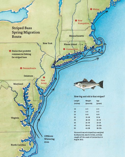
The Northwest Atlantic has been warming due to both atmospheric and oceanographic influences (e.g., Chen et al., 2014; Gawarkiewicz et al., 2019) and the impacts can bee seen in the distribution of marine species like stripers. The stripers are typically found on the New England Shelf in the spring, with bass fishing tournaments a long-held tradition for islands like Martha’s Vineyard, Nantucket, and Cuttyhunk. But conditions are changing, and as the waters warm, the stripers appear to be moving further north. Data from the NES Pioneer Array are helping researchers and fishers understand the changes.
[media-caption path="/wp-content/uploads/2022/05/Striped-Bass-migration-map.jpg" link="#"]Striped bass spring migration route. Credit: Martha’s Vineyard Gazette and Dana Gaines Martha’s Vineyard Magazine.[/media-caption]
Stripers spawn in brackish water and spend their first few years in estuarine waters like those of the Chesapeake Bay. These waters are changing too, with earlier springs modifying spawning behavior. Understanding how environmental conditions impact the life cycle of stripers from estuary to open ocean requires knowledge of the atmosphere, continental shelf waters, and the Gulf Stream. Finally, it is necessary to investigate interactions that exchange properties between estuaries, shelf and slope sea – which will be the focus of the MAB Pioneer Array currently being planned for implementation in 2024.
References
Chen, K., G. G. Gawarkiewicz, S. J. Lentz, and J. M. Bane (2014), Diagnosing the warming of the Northeastern U.S. Coastal Ocean in 2012: A linkage between the atmospheric jet stream variability and ocean response, J. Geophys. Res. Oceans, 119, doi:10.1002/2013JC009393.
Gawarkiewicz G, Chen K, Forsyth J, Bahr F, Mercer AM, Ellertson A, Fratantoni P, Seim H, Haines S and Han L (2019), Characteristics of an Advective Marine Heatwave in the Middle Atlantic Bight in Early 2017. Front. Mar. Sci. 6:712. doi: 10.3389/fmars.2019.00712.
Schneider, P. (2022), Climate Change Clue: Follow the Stripers. Vineyard Gazette, 12 May 2022.
Read MoreInitiation of a Marine Heat Wave
Adapted and condensed by OOI from Chen et al., 2022, doi:epdf/10.1029/2021JC017927.
Marine heat waves are sustained, anomalous ocean warming events with significant regional extent. In some cases, these heat waves are driven by heating from the atmosphere. In new work (Chen et al. 2022), it is shown that ocean processes can also be responsible for marine heat waves. In this case, the presence of anomalously high temperatures on the New England shelf was detected by CTD observations made by commercial fishing vessels. The fishing vessel CTD data indicated that the heat wave was a “compound event”, i.e. one with large anomalies in both temperature and salinity. Because atmospheric heating would drive only a temperature anomaly, and because the Gulf Stream derived slope water offshore of the New England shelf is high in both temperature and salinity, it was surmised that this heat wave was driven by ocean advection.
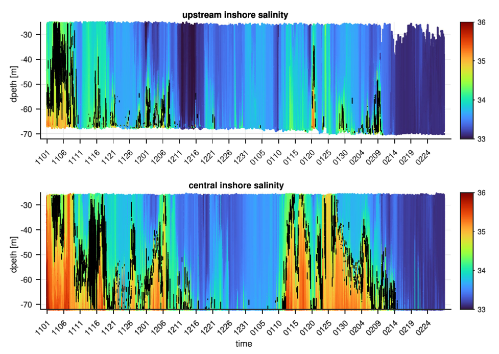
[media-caption path="/wp-content/uploads/2022/02/CGSN1.png" link="#"]Figure 23. Salinity contoured vs. depth and time for the Pioneer Upstream Inshore (PMUI) and Central Inshore (PMCI) profiler moorings from November 2016 to February 2017. The 34.5 isohaline is marked in black to highlight the boundary between the shelf and slope waters.[/media-caption]
The authors used data from Pioneer Array profiler moorings (PMUI and PMCI) to support this ocean advection hypothesis. Salinity records (Figure 23) show high salinity events in Nov/Dec 2016 and Jan 2017. The salinity anomalies are indicative of slope water (S > 34.5), are most intense at the bottom, and are more pronounced further offshore. This is consistent with a bottom intensified intrusion of warm, salty slope water onto the shelf to initiate the heat wave observed by the fishing fleet CTDs in January of 2017.
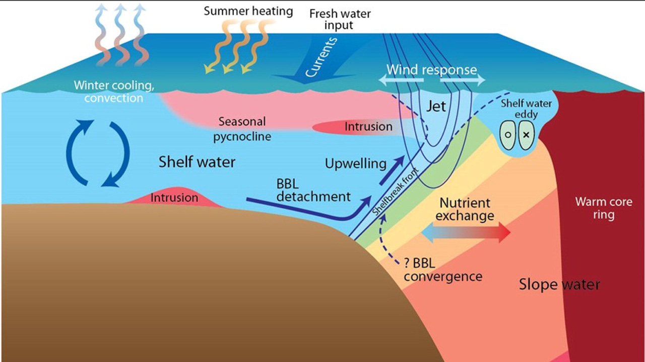
Further investigation was done to understand the cross-shelf exchange process, which presumably originated at the shelfbreak and penetrated large distances onshore as a bottom intrusion. The principal tool for the additional analysis was a new high-resolution regional model. The model was able to reproduce major features including shelf water properties, the shelf break front, and warm-core rings in the slope sea . Critically, the model showed the presence of cyclonic eddies (opposite in rotation, thinner and smaller than the warm core rings) that were responsible for driving cross-shelf flow and intensifying the front. The authors argue that these processes precondition the outer shelf by bringing warm salty water to the shelf break, i.e. roughly the 100 m isobath.
Another step is necessary to produce the dramatic, bottom intensified intrusion of warm salty water to ~50 m depth, as seen in January 2017. Further examination of the model, including runs with and without wind forcing, indicated that persistent upwelling-favorable winds along with topographic effects were the additional ingredients necessary to cause the dramatic intrusion. Although some onshore penetration results from the standard “two-dimensional” wind-driven upwelling, the authors found that details of the three-dimensional regional topography were critical to extensive slope water penetration in the form of a warm, salty, bottom-intensified tongue.
Identifying the unusually strong intrusion and finding the hints to a slope-sea origin shows the importance of sustained observing, in this case from both the Pioneer Array and the fishing fleet.
Unraveling this remarkable, multi-step process, with pre-conditioning by small-scale cyclonic eddies followed by a topographically-controlled, wind driven response, is a testament to the power of high-resolution models to fill in dynamical gaps in the observing systems. The authors note that “this study provides dynamical explanations of the observed water mass anomalies across the shelf, offers new insights about cross-shelf exchange… and lays the ground work for future studies.”
__________________________________________________________________
Chen, K., Gawarkiewicz, G., & Yang, J. (2022). Mesoscale and submesoscale shelf-ocean exchanges initialize an advective Marine Heatwave. Journal of Geophysical Research: Oceans, 127, doi:epdf/10.1029/2021JC017927.
Read MoreFishers and OOI Scientists Working Together to Advance Science
An article in the Cape Cod Commercial Fishermen’s Alliance newsletter highlighted the work between its members and scientists at Woods Hole Oceanographic Institution (WHOI), using OOI Pioneer Array data. The collaboration resulted in discovery of …“ all these things happening on the New England Shelf that we didn’t anticipate,” said Al Plueddemann, a senior scientist in physical oceanography at WHOI.
An important change in recent years is an increase in the meandering or “wiggliness” of the Gulf Stream. In addition the Gulf Stream has been generating more “Warm Core Rings,” large clockwise eddies.
Read more about how the collaboration is advancing science here.

OOI’s Contributions to Understanding the Changing Ocean Cited in Boston Globe
Woods Hole Oceanographic Institution Research Scientist Glen Gawarkiewicz cites how he uses OOI data to figure out what is happening in the changing ocean in an article on that appeared on the front page of the Boston Globe on December 28, 2021.
In a record-breaking year of weather, signs of a changed world.
[caption id="attachment_22801" align="alignnone" width="1610"]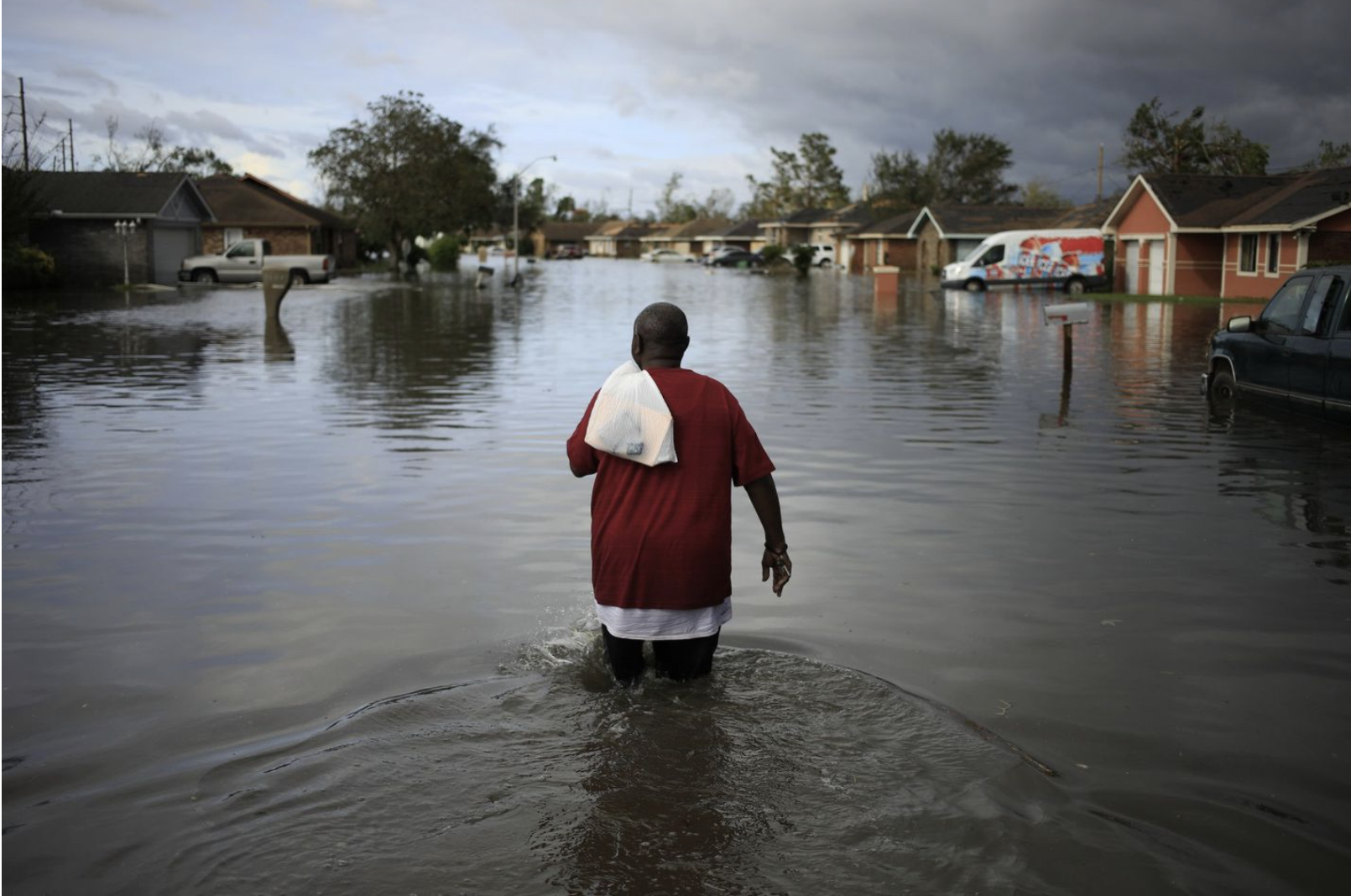 A resident walked through floodwaters left by Hurricane Ida in La Place Louisiana on August 30, 2921. Credit: Luke Sharrett/Bloomberg via the Boston Globe.[/caption]
Read More
 Pioneer Data Complements Fisher-Collected Data to Explain Ocean Processes and Fish Distributions
Since 2014, fishers in southern Rhode Island and scientists from Woods Hole Oceanographic Institution (WHOI) have been working collaboratively to share data and learn from one another. For the past seven years, fishers have been collecting oceanographic data through the Commercial Fisheries Research Foundation’s (CFRF) Shelf Research Fleet and WHOI has shared data collected by the Pioneer Array.
Through this partnership, fishers have come to value data from the Shelf Research Fleet and the Pioneer Array, as well as the insights of researchers who have spent years studying some of the most productive fisheries in U.S. waters. WHOI provides Pioneer data to fishers, and fishers provide oceanographic data collected during their normal fishing operations using CTDs which measure conductivity, temperature and depth information through the CFRF/WHOI Shelf Research Fleet. When the CTDs are brought onboard they wirelessly communicate the temperature data to an iPad where fishermen can view oceanographic conditions and ultimately upload the data to scientists. These CTD measurements provide the physical properties of sea water, which help determine the location and composition of the catch.
[caption id="attachment_20251" align="alignright" width="300"]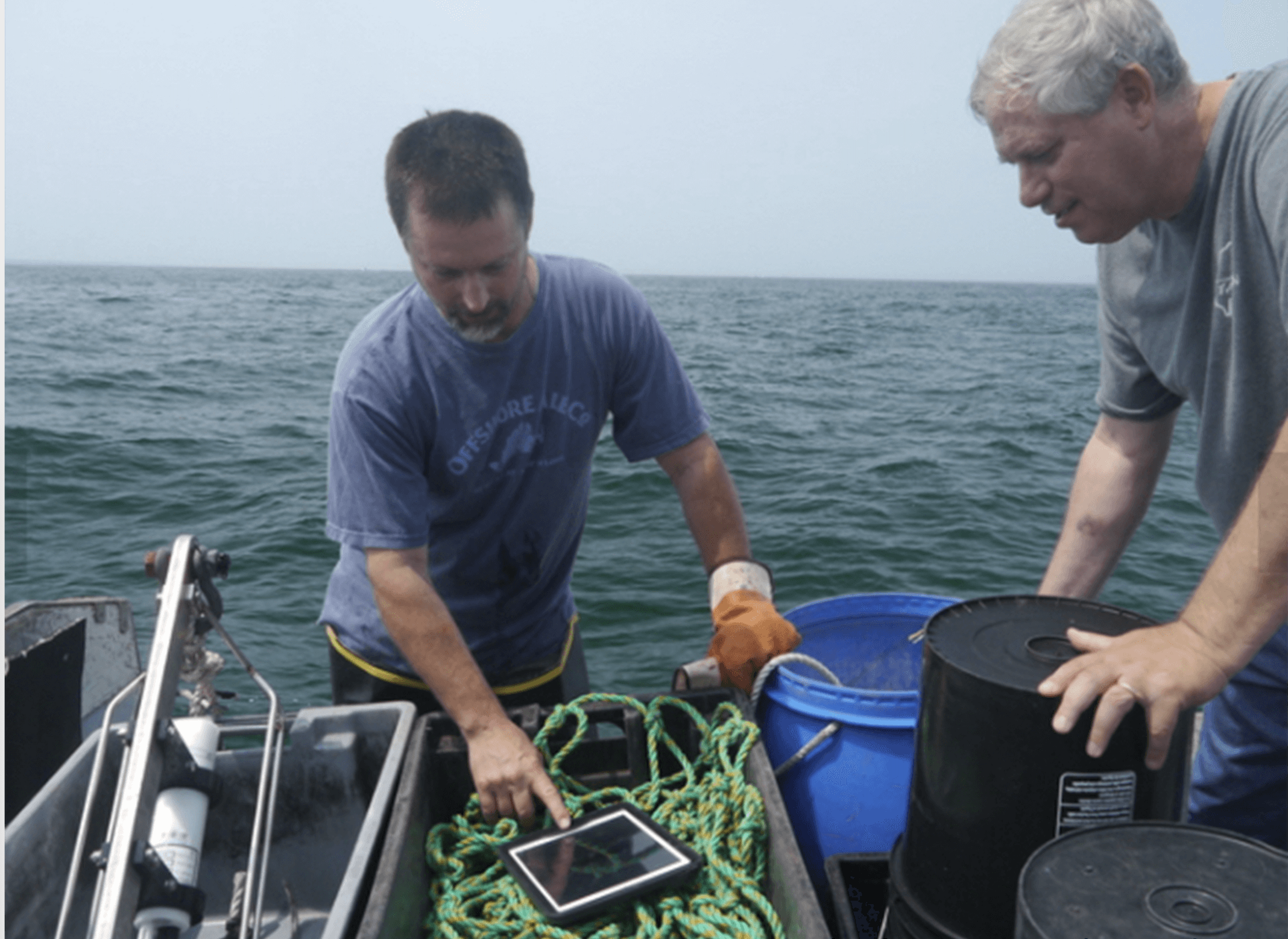 Fisher Michael Marchetti (left) and WHOI scientist Glen Gawarkiewicz discuss data collected by a portable CTD. Credit: Commercial Fisheries Research Foundation.[/caption]
“This arrangement is a good example of how if people are willing to listen and really learn to value issues that are going on for another group, remarkable things can occur,” said Glen Gawarkiewicz, a WHOI researcher who leads the CFRF -WHOI Shelf Research Fleet.
In December, Gawarkiewicz visited the sea surface temperature website maintained by Rutgers University. There he noticed a sea surface temperature image that seemed to suggest a patch of warm, salty water known as a warm core ring forming directly adjacent to the continental shelf in the vicinity of the Pioneer Array. Warm core rings form when the Gulf Stream becomes unstable. These meanders can break off forming a swirling mass of water dozens of miles across, with warm water at the center that can be transported away from the Gulf Stream and into normally cold coastal waters of New England. Once there, such eddies can disrupt ecosystems and affect weather patterns for weeks.
[caption id="attachment_20250" align="alignleft" width="300"]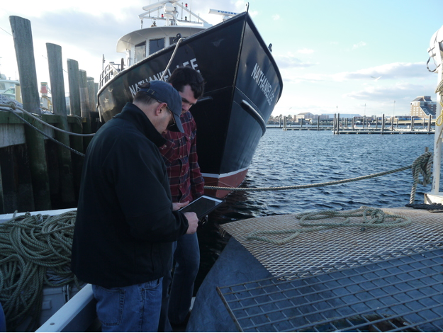 Newport Rhode Island lobsterman James Violet (foreground) reviews oceanographic data collected via CTDs on WHOI provided iPads. Credit: Commercial Fisheries Research Foundation.[/caption]
Gawarkiewicz then went to the Ocean Observatories Initiative data portal and made plots that confirmed the existence of high-salinity surface water near one of Pioneer’s offshore moorings and near the seafloor of one of the array’s inshore moorings. The conditions, he said, were very much like an event in January 2017 in which fish normally associated with warm Gulf Stream waters were caught near Block Island. The event in January 2017 was initially identified in Shelf Research Fleet data and then confirmed in Pioneer Array glider data analyzed by Robert Todd of WHOI.
Acting on the solid relationship built between WHOI and the CFRF, Gawarkiewicz emailed CFRF staff to warn them that conditions were changing and that they should be on alert for changes in the fishery. Shortly after, he received a phone call from Shelf Fleet collaborator, Aubrey Ellertson, who had reported that fishers were noticing an increase in water temperature on the bottom of the seafloor, and an impact on their catch. For some fishers, the Jonah crab fishing declined, and for others they were not seeing traditional fish species caught in their gillnets.
This exchange highlights the strong partnership between WHOI and the Rhode Island fishing fleet. The collaboration has helped participating fleet members recognize oceanographic processes and relate their fishing catch to processes discussed with WHOI scientists like Gawarkiewicz, and his colleagues Magdalena Andres, Ke Chen, and Massachusetts Institute of Technology/WHOI Joint Program graduate Jacob Forsyth. At the same time, Gawarkiewicz and his team have learned from the fishing community about the impacts of warm core rings on species distribution, their catch and, more broadly, on the shelf ecosystem.
“I knew to pass along this alert because members of the Shelf Research Fleet have taught me about what fishing outcomes are likely from some changing ocean conditions,” said Gawarkiewicz. “It is truly remarkable how much we have been able to learn from each other.”
Gawarkiewicz believes that this event demonstrates both the practical and intellectual value of the Pioneer Array data in improving understanding of sub-surface exchange processes. “Without Pioneer, we would not know the bottom salinity nor been able to give the fishers a heads-up as to what to expect. This shows how Pioneer is having a direct impact on how, when, and where people are fishing.”
To hear an audio piece with interviews with Gawarkiewicz, Aubrey Ellertson and others, listen here.
Read More
Pioneer Array Design: Building on the known to explore the unknown
The location of the Ocean Observatories Initiative Pioneer Array has been ideal for understanding recent, unprecedented changes in temperature and ocean properties on the continental shelf and slope off the coast of New England, coincident with an increase in warm core rings at a time when the Gulf Stream has grown increasingly unstable. That’s the conclusion of a review paper published last month in the Journal of Operational Oceanography.
The paper, written by Glen Gawarkiewicz and Al Plueddemann of Woods Hole Oceanographic Institution, details how the components and location of the array were determined and how the data gathered there has changed scientific questions being asked in this critical region. The array also provides a unique observatory model that can be applied in other shelf break regions across the world.
“We already knew a fair bit about what was happening in the region, but what we’re seeing now isn’t what we expected,” said Plueddemann. “Fortunately, the array was designed and constructed in such a way that we were ready for just about anything.”
The shelf break front stretches along the U.S. Northeast Coast from Georges Bank to Cape Hatteras, dividing cooler, fresher waters of the coast and continental shelf from warm, saltier waters of the slope. It is a complex, productive, and constantly changing area, driven by the interaction of winds, currents, and offshore rings.
Prior to the Pioneer Array, data from the shelf break came primarily from stationary moored instruments or from short-term, mobile observations provided by ocean gliders and towed shipboard systems. In designing the Pioneer Array, scientists and engineers working with the NSF-funded Ocean Observatories Initiative integrated moorings, gliders and propeller-driven AUVs to provide a long-term, multi-dimensional data set that blends the advantages of multiple observing technologies. This is particularly important as ocean processes occurring at the shelf break occur on a variety of space and time scales.
Gawarkiewicz and Plueddemann point out that in addition to enabling new scientific discovery, data from the Pioneer Array has the potential for real-time applications to help track and forecast hurricanes and winter storms, improve search-and-rescue operations, and the siting and operation of off-shore wind installations.
Since becoming operational in 2016, the Pioneer Array has gathered near-continuous data across a 24,000 square-kilometer swath of the shelf break region. By combining moorings, gliders, and AUVs, the array has provided the scientific community with high-resolution observations across space and time, which are unprecedented in their scope and detail and are also freely available on the Ocean Observatories Initiative data portal.
“We haven’t even scratched the surface yet,” said Plueddemann. “There’s still lots of potential to mine in the Pioneer Array data.”
The Ocean Observatories Initiative (OOI) is a long-term infrastructure project funded by the National Science Foundation to gather physical, chemical, and biological data from the ocean, atmosphere, and seafloor and to deliver that data on demand and in near real-time online. The program includes fixed instruments and autonomous underwater vehicles deployed at key locations off in U.S. coastal waters and in the open ocean. The OOI currently maintains arrays off the Northeast and Northwest coasts of the U.S., the Irminger Sea southeast of Greenland, and at Station Papa in the Gulf of Alaska, as well as a seafloor cabled array off the coast of Oregon. Data from the arrays help researchers address questions ranging from rapidly changing weather events to long-term climate change and from air-sea interaction to sea floor processes. OOI is managed by the Woods Hole Oceanographic Institution (WHOI) and implemented by WHOI, the University of Washington, Oregon State University, and Rutgers, the State University of New Jersey.
Read More

