
Posts Tagged ‘Global Irminger Sea Array’
Advancing Mooring Technology for Long-Term Ocean Observation
Advances in oceanographic mooring technology are critical to sustaining long-term, high-quality observations in some of the planet’s harshest environments. Moorings must now operate reliably over extended deployments, support increasingly sophisticated instrumentation, and withstand the growing impacts of extreme weather. To better understand recent progress and ongoing challenges in this field, we spoke with Alex Franks, Research Engineer at Woods Hole Oceanographic Institution (WHOI) and a key contributor to the Ocean Observatories Initiative (OOI).
Over the past three years, Franks and his team have introduced significant upgrades to OOI infrastructure – most notably enhancements in satellite telemetry, power generation and management systems, and the structural resilience of both surface and subsurface moorings. These improvements aim not only to extend deployment lifetimes and reduce maintenance needs but also to expand the scientific capabilities of moorings by accommodating higher-bandwidth data streams and more energy-intensive instruments.
This Q&A offers a detailed look at the evolving strategies behind mooring system engineering and the practical steps being taken to meet both scientific demands and environmental challenges.
- In the last 3 years, what have been the most notable improvements in remotely diagnosing and fixing mooring issues?
The biggest upgrade we’ve implemented recently is a new satellite telemetry module called the “Stream +” (Stream Plus). This allows us to communicate with the buoys in a faster and more streamlined manner. I would compare the upgrade being the difference between dialup and high-speed internet. This unit was originally tested on the Irminger Sea Surface Mooring deployed in 2024 and has now been deployed at the Pioneer Array on the Central Surface Mooring and one of the Profiler Moorings. With this increased ability to troubleshoot and interact, we are able to support high bandwidth instrumentation like the Mclane IFCB (Imaging Flow Cytobot) which takes pictures of phytoplankton in real time. We are able to download a subset of the images and adjust camera focus remotely now. OOI can now also accommodate proposals for more high bandwidth instrumentation on the buoy systems.
- What new features are you currently developing to further improve mooring system reliability?
The OOI Electrical Engineering group is currently focusing on reducing power consumption and increasing reliability of power generation systems on the Surface Moorings. Several systems are being optimized including individual instrument power supplies and Surface Mooring seabed-located multifunction node (MFN) power transmission. We are also upgrading the solar panels to harvest even more energy from the sun during long deployments. Lastly, the wind turbines on the Surface Moorings have been further ruggedized to help withstand the 20-meter waves and hurricane force winds that we observe at our global sites. A test of that redesign is underway at the Pioneer Array. All of these optimizations and upgrades will result in a mooring that can accommodate new power-hungry instrumentation, exceed our current sampling scheme, and withstand doldrums or high latitude winter with little to no solar generation.
At OOI we are also starting to think about more onboard computing power, more data storage, and more expandability in terms of available ports for new instrumentation. We always have our eye on streamlining our current electronics.
- Looking ahead, what do you see as the next major breakthrough in mooring technology?
I’m looking forward to testing solid state batteries as they are developed for use on mooring systems. The benefits of lithium with less safety concerns are very interesting to me. Losing battery weight and gaining more usable energy storage is a very attractive prospect.
- Are there any upcoming field tests or deployments that you’re particularly excited about?
OOI is partnering with Sandia Labs and the Department of Energy to develop and deploy a prototype of a wave energy converter on the Central Surface Mooring in fall of 2025. This device will be situated inside the buoy and convert wave motion into mooring power as proof of concept. This project has been going on for a few years now and it’s very rewarding to see it coming to fruition.
Advancements in mooring technology are directly improving data quality, reliability, and access for long-term ocean observations.
To explore available datasets and learn more about current system capabilities, visit oceanobservatories.org.
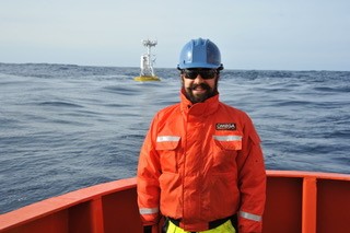
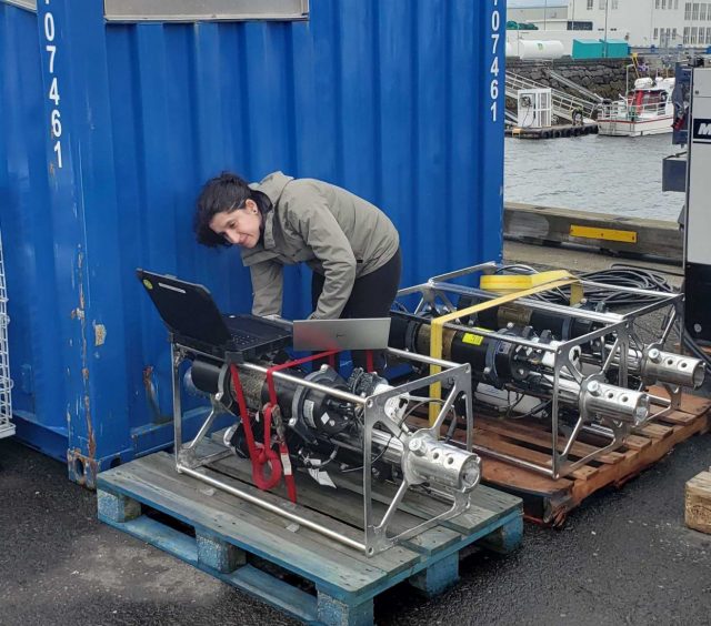
[caption id="attachment_36486" align="alignnone" width="320"] Compass characterization procedure at the LOSOS building. Pictured: Alex Franks, WHOI[/caption]
Read More
Compass characterization procedure at the LOSOS building. Pictured: Alex Franks, WHOI[/caption]
Read More Irminger Sea Wind Speed Validation
The Irminger Sea in the North Atlantic is a stormy, windy place. Consequently, it is an area of interest for studying the flux balance of heat, momentum, and biogeochemically important gasses such as CO2. The Ocean Observatories Initiative (OOI) deploys meteorological instruments in the Irminger Sea, as part of the OOI Global Irminger Sea Array, to collect in-situ observations in this relatively undersampled region. The goal is to deliver high-quality, long-term observations to the ocean science community to study these, and many more, questions of interest.
Validating these measurements is an important part of delivering quality data to the ocean science community. This summer, rising senior at California State University – Monterey Bay Aaron Wickware took on the challenge of validating OOI wind measurements in the Irminger Sea. Aaron was a Woods Hole Partnership in Education Program (PEP) scholar. PEP is a program designed primarily for college juniors and seniors from underrepresented groups who want to spend a summer gaining practical experience in marine and environmental science. The program consists of an accredited course in global climate change and a ten-week research project.
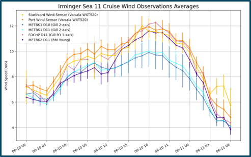
At Aaron’s disposal were six different sensors: a Gill Windobserver II two-axis sonic anemometer, R.M. Young Wind Monitor propeller-driven anemometer, and a Gill R3 three-axis sonic anemometer integrated into the direct flux covariance instrument (FDCHP) on the recently deployed Irminger Sea surface mooring; a Gill Windobserver II on the surface mooring to be recovered; and the two Vaisala sonic anemometers located on the ship’s mast. Aaron downloaded all the data, identified the overlapping time periods, calculated the wind speeds from the u-and-v-vector components, adjusted the speeds to a common-height using a community standard bulk flux algorithm (COARE 3.5), and took the 1-hour averages. His resulting comparison demonstrated that the two Gill two-axis sonic anemometers under-reported wind at speeds greater than 8 m/s. His workflow and analysis code are accessible on his GitHub page at https://github.com/Aaron-Wickware/ooicgsn-wind-validation.
Aaron’s results are part of a broader OOI Data Team investigation into the accuracy of buoy-based sonic anemometer wind measurements. This work is being followed up by similar sensor cross-comparisons at other mooring arrays. The results will be incorporated into a report to facilitate the use of data from the OOI-deployed buoy-based anemometers.
[caption id="attachment_34892" align="alignnone" width="493"] Figure 1. Comparison of hourly-averaged wind speeds with standard deviations from the six available wind sensors all operating at the same time at the OOI Global Irminger Sea Array.[/caption]
Read More Global Station Papa Expedition Succeeds Despite Weather
And what a wild ride it was! The US National Science Foundation Ocean Observatories Initiative (OOI) 11th expedition to the Global Station Papa Array aboard the R/V Sikuliaq had a bit of trouble with the weather gods during its 17-day journey in the Gulf of Alaska. For safety reasons because the ship cannot deploy large moorings in conditions with ~20’ seas and high winds, the ship spent almost five of the 17-days moving in and out of the array site, trying to find “safer ground” to wait out the worst of the storms.
Nonetheless, the Coastal and Global Scale Nodes team (CGSN) based at Woods Hole Oceanographic Institution (WHOI) and a Waverider mooring team from the University of Washington succeeded in meeting all their mission objectives. Despite the extra transit and down days, the teams recovered and deployed three OOI subsurface moorings and two open ocean gliders. They recovered and deployed a Waverider mooring for the University of Washington. A POGO Fellowship awardee was onboard and gained valuable shipboard experience, including experiencing how safety is the underlying foundation of these at-sea operations.
[media-caption path="https://oceanobservatories.org/wp-content/uploads/2024/06/Hybrid-1.jpg" link="#"]The CGSN team successfully deployed a Hybrid Profiler Mooring (HYPM) at the Station Papa Array. The HYPM is in a water depth of ~4000m and is equipped with two profiling vehicles that move up and down the riser wire at regular intervals to collect data for almost the full water column. An anchor (left) holds the mooring in place during its yearlong deployment. Credit: Dee Emrich © WHOI.[/media-caption] [media-caption path="https://oceanobservatories.org/wp-content/uploads/2024/06/hybrid2.jpg" link="#"] An anchor holds the Hybrid Profiler mooring in place during its yearlong deployment. Credit: Dee Emrich © WHOI.[/media-caption]The team also successfully conducted water sampling at the deployment sites and collection of shipboard underway data.
“It was a pleasure participating in the Papa 11 cruise with such a professional and able team,” said Chief Scientist Kristopher Newhall. “And as always, I can’t say enough about the skill and professionalism of the R/V Sikuliaq’s officers and crew.” This is the fifth time Newhall has led the annual recovery and deployment cruise to Global Station Papa.
[media-caption path="https://oceanobservatories.org/wp-content/uploads/2024/06/Biofouling-2.jpg" link="#"]In addition to deployments of OOI moorings and gliders, the CGSN team assisted colleagues at the University of Washington Applied Physics Laboratory deploy a waverider mooring at the Global Station Papa Array, providing wave data wave such as height, period, and direction from this important site. Credit: Dee Emrich © WHOI.[/media-caption]The site is in the Gulf of Alaska, about 620 nautical miles offshore, in a critical region of the northeast Pacific with a productive fishery subject to ocean acidification, low eddy variability, and impacted by the Pacific Decadal Oscillation. “We are pleased that Station Papa is now set to provide data for the next year from this critically located region,” Newhall added.
A more detailed report of the expedition can be found here.
[media-caption path="https://oceanobservatories.org/wp-content/uploads/2024/05/IMG_6769-scaled.jpeg" link="#"]Credit: Jim Edson © WHOI.[/media-caption]
Read More
Two OOI Expeditions in Two Oceans
11th Recovery and Deployment of Global Station Papa and Irminger Sea Arrays
Two OOI Global Scale and Nodes (CGSN) teams are working simultaneously, but in different waters on opposite sides of the United States during June. The first CGSN team left Seward, Alaska aboard the R/V Sikuliaq on May 29 for a 17-day expedition to recover and re-deploy the Global Station Papa Array in the Gulf of Alaska. On June 2, a second CGSN team will depart from Woods Hole, MA to travel to the Irminger Sea Array aboard the R/V Neil Armstrong for a month-long expedition to recover and re-deploy this array.
The expeditions share similarities and differences. Both arrays are in remote locations. The Station Papa team has a 2.5-day transit to the array site in the Gulf of Alaska, while the Irminger Sea team has a longer transit of eight days to the array site. Once onsite, the teams will get to work quickly to deploy the replacement moorings to allow for overlapping measurements before recovering the moorings currently in place. This is the 11th time that each array has been turned – that is, existing ocean observing equipment at the sites will be recovered and replacement equipment will be deployed in their place. Such “turns” are needed to address biofouling of sensors, depletion of batteries, and wear and tear on equipment that has been battered by wind, waves, and weather for a year.
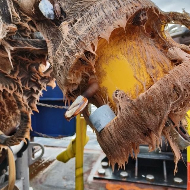
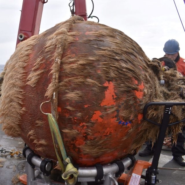
[media-caption path="https://oceanobservatories.org/wp-content/uploads/2024/05/Biofouling.jpg" link="#"]This is what one year in the ocean looks like: a Global Station Papa flanking mooring 64” sphere with 12 months of marine growth. Marine growth can inhibit the operation of the mooring and instruments and is one of the reasons we need to recover and refurbish the OOI infrastructure on a regular basis. Credit: Rebecca Travis © WHOI.[/media-caption]The Global Station Papa Array is located in the Gulf of Alaska, about 620 nautical miles offshore in a critical region of the northeast Pacific with a productive fishery subject to ocean acidification, low eddy variability, and impacted by the Pacific Decadal Oscillation. The Global Irminger Sea Array in the North Atlantic is located in a region with high wind and large surface waves, strong atmosphere-ocean exchanges of energy and gases, carbon dioxide sequestration, high biological productivity, and an important fishery. It is one of the few places on Earth with deep-water formation that feeds the large-scale thermohaline circulation.
“Because of their remote locations, both Station Papa and the Irminger arrays provide critical ocean data that scientists are using to better understand ocean circulation patterns and help identify changes in ocean conditions,” said Sheri N. White, Chief Scientist for the Irminger 11 expedition. “These arrays are hard to get to and to maintain but the data they provide are invaluable.”
Expedition Activities
A team of 11 scientists and engineers aboard the R/V Sikuliaq departed from Seward on May 29 for a 17-day expedition. During their time at sea, they will recover and deploy three OOI subsurface moorings and two open ocean gliders. They also will recover and deploy a Waverider mooring for the University of Washington. A POGO Fellowship awardee will be onboard to gain shipboard experience as part of OOI’s collaborative efforts to provide early career scientists opportunities to help increase their knowledge and advance careers. Other onboard activities will include water sampling at the deployment sites and collection of shipboard underway data.
[media-caption path="https://oceanobservatories.org/wp-content/uploads/2024/05/Irminger-gliders.jpeg" link="#"]The OOI CGSN science team will start operations at the Irminger Array by deploying two gliders. This allows the gliders to be monitored by the pilots onshore and ensure all systems are operational while the vessel is still onsite performing mooring operations. These gliders will operate autonomously at Irminger for ~12 months. Credit: John Lund © WHOI.[/media-caption]On the east coast, a second team of 15 scientists and engineers aboard the R/V Neil Armstrong will leave Woods Hole, Massachusetts on June 2 to begin their eight-day transit to the Irminger Sea. Once onsite, the team will recover and deploy four OOI moorings, deploy two gliders, recover a third, and conduct water sampling at the deployment sites. Underway shipboard data will also be collected throughout the voyage. Four additional subsurface moorings will be “turned” for the Overturning in the Subpolar North Atlantic Project (OSNAP). Water and biogeochemical sampling will be conducted in support of both OSNAP and researchers from Boston College. A marine mammal observer from NOAA will be onboard as a continuing collaboration between NOAA and OOI.
Added White, “When planning these expeditions, we do our best to maximize use of ship time by providing berths to researchers who could benefit from direct observation and data collection in these remote locations. During the expedition to Irminger, for example, we will be joined by a graduate student and two undergraduate students from Boston College who will collect biogeochemical data, and experience what it is like to do science at sea.”
A bird’s eye view of a previous Irminger Sea Array expedition:
[embed]https://www.youtube.com/watch?v=LF6Zhmlmd0A[/embed]Daily reports will be filed from both expeditions. Bookmark this site to follow along.
Read More
Mission Accomplished Despite High Seas, Strong Winds
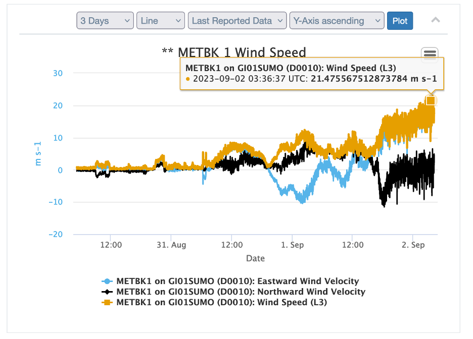
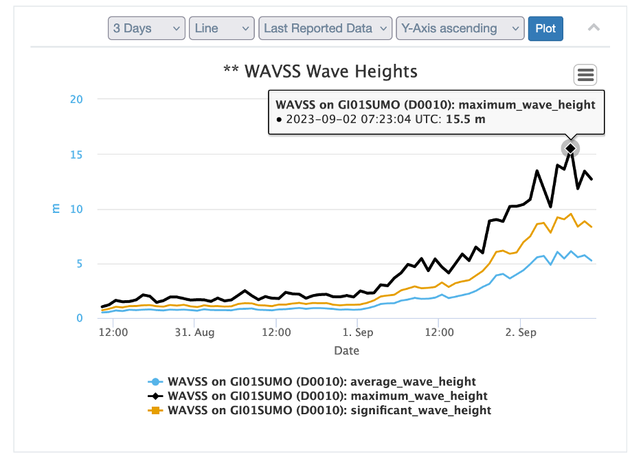
The Irminger 10 Recovery and Deployment Expedition had to keep a close eye on weather conditions. After arriving at the Irminger Sea Array site aboard the R/V Neil Armstrong, the ship was forced to take shelter in Prince Christian Sound off Greenland for two days to avoid 21.5 m/s (42 knot) winds and waves measuring more than 15.5 meters high (50 feet) as measured by the OOI Surface buoy (SUMO-10) meteorological systems.
The team returned to the site once conditions settled down enough to work safely. The team monitored the weather carefully planning operations that fit the varying conditions and were able to squeeze out enough safe, workable days to accomplish the cruise’s primary objectives, and then some.
[media-caption path="https://oceanobservatories.org/wp-content/uploads/2023/09/global-surface-mooring.jpg" link="#"]The recovered global surface mooring was successfully brought onboard, secured, and ready for the long trip home. Credit: John Lund © WHOI.[/media-caption]The ship departed the Irminger Array on September 12th and headed for the last CTD (Conductivity, Temperature, and Depth) measurement at OSNAP Station M4 on the way home to Woods Hole, MA, which completed the cruise objectives. Despite the obstacles posed by conditions in this windy and wild part of the norther Atlantic, four moorings were deployed and recovered. Two open ocean gliders and one global profiling glider were deployed. CTD casts for instrument cross calibration were made during each deployment/recovery. Meteorological surveys were conducted and ancillary CTD casts to support the OSNAP program were made. In addition, a significant number of marine mammal sightings were recorded.
Conditions didn’t cooperate as the team headed home. The Captain of the Armstrong had to carefully pick a transit to avoid Hurricanes Lee and Margot turning up the Atlantic.
Said Chief Scientist John Lund, “The success of this cruise is a result of the tremendous teamwork from the Armstrong crew, shoreside support, and the OOI and CRL engineers and technicians who prepared and deployed the Irminger-10 assets. Their hard work has made possible the data that will be sent home for the next year.”
The ship and its hard-working team are expected to arrive back at the Woods Hole dock on September 21. More details about the expedition and images and video are available here.
Read More
Tenth Refresh of the Irminger Sea Array
On August 27th, a team of 13 scientists and engineers boarded the R/V Neil Armstrong in Reykjavik, Iceland to head to the Irminger Sea Array. Most of the array’s infrastructure and instrumentation was shipped from Woods Hole Oceanographic Institution (WHOI) in mid-July to Iceland, where it arrived in mid-August. Part of the scientific party traveled to Reykjavik in mid-August to reassemble the moorings and conduct a “burn-in,” a test period for the power, data, telemetry, and instrument systems to ensure everything is operational prior to loading the vessel.
The Irminger Sea Array is in a region with high wind and large surface waves in the North Atlantic and is one of the few places on Earth with deep-water formation that feeds the large-scale thermohaline circulation. Data collected by the Irminger Sea Array are providing critical insights into circulation patterns, ocean processes, and possible climate-induced changes occurring in this important oceanic area.
After an ~ two-day transit (550 nautical miles) to the array site off the tip of Greenland, the team will recover and deploy four moorings and three gliders over the next two and a half weeks. They will conduct CTD (conductivity, temperature, and depth) casts at the deployment/recovery sites and carry out shipboard sampling for field validation of the platforms and sensors that will remain in the water for the next year.
In addition to the recovery and deployment operations, the team will be conducting some CTD calibration casts in support of OSNAP-GDWBC (Overturning in the Subpolar North Atlantic Program-Greenland Deep Western Boundary Current). A participant from the National Oceanic and Atmospheric Administration will also be on board using “Big Eye” binoculars mounted on a forward deck to make observations of marine mammals during the transit and in the Irminger Sea.
[media-caption path="https://oceanobservatories.org/wp-content/uploads/2023/08/Big-eyes.jpg" link="#"]Large, deck-mounted binoculars known as “big eyes” are used for marine mammal observations. NOAA Research Wildlife Biologist Peter Duley will be aboard the R/V Neil Armstrong watching for marine life in the Irminger Sea. Credit: Al Plueddemann ©WHOI.[/media-caption]The Irminger Team will also be testing out some equipment modifications on this deployment. One change is an updated satellite telemetry system. This system would provide higher bandwidth allowing better and quicker data transmission from the global surface mooring potentially saving power, and better remote command and control of the mooring systems. Another change is a revised mounting scheme for the glider optode, which measures dissolved oxygen concentrations in the water column. The new mount may provide better in-air measurements during glider surfacing. The in-air measurements allow scientists to characterize the changing accuracy of the instrument over time.
“It’s always a challenge to get ready for this month-long expedition to this remote, but critical region, but we are ready and eager to get there,” said John Lund, Chief Scientist for Irminger 10. “We are pleased to play a part in collecting data that scientists are using to better understand changes occurring in this region, with implications for both weather and climate.”
The team will reporting regular updates from the field. Bookmark this page so you can follow along on their progress.
Read MoreDrivers of Ocean Overturning Circulation Revealed
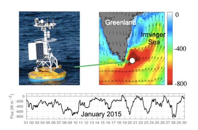
rminger Surface Mooring data were used to identify a new mechanism by which the atmosphere controls ocean heat loss leading to dense water formation. The results are particularly important as the connection between air-sea exchanges and the ocean circulation is still poorly understood, hindering attempts to understand the climate change induced slowdown of the Atlantic circulation.
Read MoreCadet Reports on First Voyage on a Research Vessel
Massachusetts Maritime Academy First-Class Cadet, Ella Strano, recently returned from two months aboard the R/V Neil Armstrong. Ella participated as a working crew member for the recovery and deployment of OOI’s Global Irminger Sea Array in July, followed by deployment of moorings and sampling equipment for the Overturning in Subpolar Arctic Project (OSNAP). She had a few days in shore in Reykjavik, Iceland, as the science parties and equipment were swapped out and onboard.
In a word, Ella described her experience as “Awesome!” and one that was a very different experience than that of her peers’ summer internships shipboard experiences. The majority of cadets at the Massachusetts Maritime Academy shipped out on cargo vessels and bulk carrier tugs for their first experiences of life at sea.
Being one of a few stationed on research vessels presented both opportunities and challenges.
“I definitely had to go with the flow,” she explained. “But l had the opportunity to learn not only from the crew, but from the scientists on board.” Ella’s minor is marine biology so she enjoyed the science aspects of the expedition, even though her responsibilities were primarily with helping to keep the ship operational so the science could be conducted.
Part of MA Maritime’s mission is to provide their students with hands-on at-sea experience so they understand the language and culture of shipboard life. In meeting the spirit of the experience, Ella did almost everything aboard the ship while she was a mate on the Armstrong. During the Irminger expedition, her duties were mostly on deck. She worked with the mooring team and observed how deployment and recovery operations could be conducted safely and successfully. Ella joked that she also did her fair share of cleaning the ship during her first month at sea.
[media-caption path="/wp-content/uploads/2022/09/Working-Aframe-2-scaled.jpg" link="#"]Ella Strano operating the Aframe used to recover and deploy OOI moorings. [/media-caption]During her second stint for the OSNAP expedition, her duties turned more inward and included work in the engine room, on the bridge, and even helped maneuver the ship to stay on station—a critical task for any science operation at sea. She had her hand in everything on the ship, except for the galley, which was left to the professionals.
Ella also experienced a fair share of weather during her initial trip to the North Atlantic, but was pleased that in spite of some low-pressure and high wind days, the ship never had to abandon its mission to find shelter from the weather.
After two months at sea, Ella said it affirmed what she’s interested in doing after graduating next year. After disembarking from the Armstrong, she said, “I love this. It’s so cool that people get to go out to sea and be involved with science, but not necessarily specialize in one area of science.” She sees life aboard a research vessel as offering her the opportunity to be involved with many different science initiatives, learn what’s going on, and never get bored.
Ella said there seems to be an uptick of interest in working aboard science research vessels as she was one of seven of her classmates who sought such a placement, and only three succeeded. If this holds true that would be good news for research ships, which often have to compete for staff who have the potential to earn more working aboard commercial vessels.
Ella’s experience offered something of greater value to her. “There was a really good camaraderie between the science group and the officers,” she explained. “We were all working together and share experiences during mealtimes and cheese-30 every day”. (A spread of cheese and meats is provided every day at three o’clock aboard the Armstrong as a break and snack). “The crew really tried to make life pleasant aboard the ship, which was great because we were at sea for a long time.”
[media-caption path="/wp-content/uploads/2022/09/ella-on-bridge.png" link="#"]Ella Strano on the bridge of the R/V Neil Armstrong. [/media-caption]If all goes as planned, Ella will graduate next year with a Bachelor of Science Degree in Marine Transportation from MA Maritime and with an enlisted unlimited tonnage, third officer certificate from the U.S. Coast Guard. She hopes to find a place aboard the Armstrong or other science-related position, inspired by a full female bridge team, and science party comprised of 50 percent women, and led by a female chief scientist, all of whom showed her what is possible.
Read More
Despite Weather, Irminger 9 Met Objectives
The R/V Neil Armstrong departed Woods Hole, Mass., on June 20. Under the direction of Chief Scientist Sheri N. White of Woods Hole Oceanographic Institution (WHOI), the 14-member science party headed to OOI’s Global Irminger Sea Array for the ninth time to recover and deploy moorings and gliders and carry out scientific sampling. Nearly a month later, the ship and science party pulled into the port of Reykjavik, Iceland, on July 16th, having accomplished all of its objectives.
“The Irminger Sea can be a challenging environment to work in. Storms with high winds and seas regularly move through the area, and these conditions can limit our mooring recovery and deployment operations,” said Chief Scientist Sheri N. White. “We were lucky to have relatively good weather conditions during our cruise, and adjusted our schedule when needed when storms passed through. Thanks to an excellent team – the ship’s crew and shipboard science technicians, the mooring operations team, and OOI and OSNAP teams – we able to accomplish all of our goals. My huge thanks to everyone on the ship and all of our shore-side support for all of their efforts.”
In addition to ten OOI personnel, the team was rounded out by three members from OSNAP (Overturning in the Subpolar North Atlantic Program) and a marine mammal observer from the National Oceanic and Atmospheric Administration.
For OOI, the team successfully recovered and deployed a Surface Mooring, Hybrid Profiler Mooring, and two Flanking Moorings, and deployed two new Irminger Sea gliders. For OSNAP, the team recovered and deployed four new moorings, replacing those originally deployed in the Summer 2020. The team also conducted CTD casts with salinity, oxygen, carbon, nutrient and chlorophyll water sampling. These sampling measurements are used for instrument validation and to further characterize the region of the moored array.
Why the Irminger Sea?
The Global Irminger Sea Array is off the southeast tip of Greenland, close to 39°W, 60°N. Data from this location are improving understanding of the impact of natural and climate variability in the region. The location experiences strong air-sea interaction and wintertime water mass formation that supports the global thermohaline (a.k.a. meridional overturning circulation – MOC). In recent years, a freshening of the water column has been observed.
The combination of the moored array and the gliders in the Irminger Sea enables investigation into the role of ocean processes at mesoscale and sub-mesoscale horizontal length scales through observations that sample the full water column, from the sea floor to the sea surface. The Surface Mooring provides a unique time-history of observations of surface meteorology and air-sea fluxes.
A Look at Life at Sea
The following and in the sidebar to the right is an assortment of activities onboard the Armstrong during the month of July. Other images and stories can be found here.
[media-caption path="/wp-content/uploads/2022/07/Pete_bow.jpeg" link="#"]Whale sightings: Marine mammal observer Peter Duley spent many hours on deck looking for marine mammals. He observed Humpback, Beaked, Sei, and Fin whales, as well as orcas, harbor porpoise and common dolphins. Credit: Sheri N. White © WHOI.[/media-caption] [media-caption path="/wp-content/uploads/2022/07/pilot-whales_sm-2048x1365-1.jpeg" link="#"]Pod came to visit: A pod of pilot whales on a foggy day in the Irminger Sea. Credit: Peter Duley, NOAA.[/media-caption] [media-caption path="/wp-content/uploads/2022/07/Glider_DSC_0381.jpeg" link="#"]Glider missions: Gliders have two missions at the Irminger Sea Array. They travel around the triangular array to collect data (temperature, salinity, fluorescence and dissolved oxygen) in between the moorings. And, they pass the data from the subsurface mooring to shore. When they come to the surface, they send their data and the subsurface mooring data back to shore via satellite. Credit: Sawyer Newman©WHOI.[/media-caption] Read MoreMeasurements Below the Surface
Strong winds and large waves in remote ocean locations don’t deter the Ocean Observatories Initiative (OOI) from collecting measurements in spite of such extreme conditions. By moving the moorings below the surface, the OOI is able to secure critically important observations at sites such as the Global Station Papa Array in the Gulf of Alaska, and the Global Irminger Sea Array, south of Greenland. These subsurface moorings avoid the wind and survive the waves, making it possible to collect data from remote ocean regions year-round, providing insights into these important hard-to-reach regions.
Instrumentation on the surface mooring in the Irminger Sea, however, has nowhere to hide and the measurements they provide are also often crucial for investigations, such as net heat flux estimates. Providing continuous information about wind and waves remains one of the most challenging aspects of OOI’s buoy deployments in the Irminger Sea. Fortunately, with each deployment, OOI is improving the survivability of the surface mooring so they continue to add to the valuable data collected in the region by their subsurface counterparts.
[media-caption path="/wp-content/uploads/2022/07/FLMB-9_DSC_0934.jpg" link="#"]The top sphere of a Flanking Mooring being deployed through the R/V Neil Armstrong’s A-Frame. Credit: Sawyer Newman©WHOI.[/media-caption]Below the surface in the Irminger Sea
A team of 15 OOI scientists and engineers spent the month of July in the Irminger Sea aboard the R/V Neil Armstrong, recovering and deploying three subsurface moorings there, along with other array components. The Irminger Sea is one of the windiest places in the global ocean and one of few places on Earth with deep-water formation that feeds the large-scale thermohaline circulation. Taking measurements in this area is critical to better understanding changes occurring in the ocean.
OOI’s Irminger Sea Array also provides data to an international sampling effort called OSNAP (Overturning in the Subpolar North Atlantic) that runs across the Labrador Sea (south of Greenland), to the Irminger and Iceland Basins, to the Rockall Trough, west of Wales. The OOI subsurface Flanking Moorings form a part of the OSNAP cross-basin mooring line with additional instruments in the lower water column. During this current expedition, the Irminger Team will be recovering and deploying OSNAP instruments that are included as part of the OOI Flanking moorings, in addition to turning several OSNAP moorings as well.
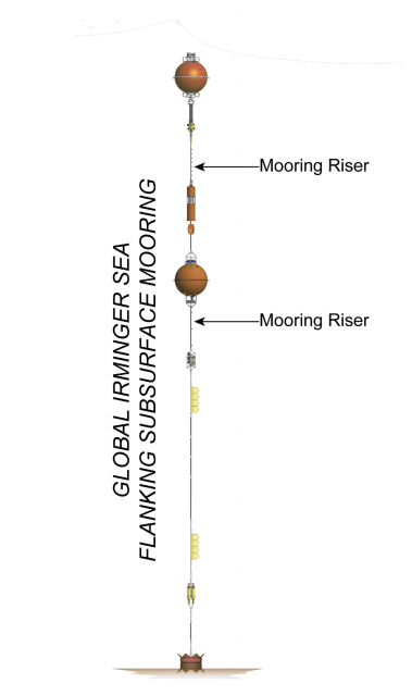
[media-caption path="/wp-content/uploads/2022/07/FLMB-9_DSC_0941.jpg" link="#"]The Flanking Mooring top float in the water during deployment. The sensors mounted in the sphere will measure conductivity, temperature, fluorescence, dissolved oxygen and pH at 30 m depth. Credit: Sawyer Newman©WHOI.[/media-caption]The triangular array of moorings in the Irminger Sea provide data that resolve horizontal variability, how much the physical aspects of the water (temperature, density, currents) and its chemical properties (salinity, pH, oxygen content) change over the distance between moorings. The individual moorings resolve vertical variability – the change in properties with depth. Three of these moorings are entirely underwater, with no buoy on the surface. They do have, however, multiple components that are buoyant to keep the moorings upright in the water column.
[media-caption path="/wp-content/uploads/2022/07/FLMB-9_DSC_0984.jpg" link="#"]The mid-water sphere holds an ADCP instrument which will measure a profile of water currents from 500 m depth to the sea surface. Photo Credit: Sawyer Newman©WHOI.[/media-caption]Each subsurface mooring has a top sphere at 30 m depth, a mid-water sphere at 500 m depth, and back-up buoyancy at the bottom to ensure that the mooring can be recovered if any of the other buoyant components fail. Instruments are mounted to the mooring wire to make measurements throughout the water column.
[media-caption path="/wp-content/uploads/2022/07/FLMB-9_IMG_5328.jpg" link="#"]Glass balls in protective “hard hats” provide extra flotation at the bottom of the mooring. Their tennis ball yellow color looks almost fluorescent in the brief (and much enjoyed) sunshine. Photo Credit: Sheri N. White©WHOI.[/media-caption] Read More