
Posts Tagged ‘Pioneer Array Relocation’
Instrumentation Updates for Planned Pioneer MAB Array
Community Input
The Ocean Observatories Initiative Facilities Board (OOIFB), sponsored by the National Science Foundation (NSF) and in partnership with KnowInnovations, facilitated two community workshops, called Innovations Labs, that resulted in the decision to relocate the Pioneer Array to the southern Mid-Atlantic Bight (MAB). The second Lab included community input on measurements that would be desirable for the relocated array. More than 40 instruments or measurement types were discussed. This was reduced to about a dozen high-priority recommendations based on consensus among the Innovations Lab sub-groups. After considering applicability to the science themes, technical readiness level, operational feasibility, and budget impacts the OOI Program was able to implement the majority of the high-priority recommendations.
Among the goals for the relocation process was to optimize the use of existing inventory, and it was possible to do so while addressing several of the instrumentation recommendations. In some cases, new procurements were required, although it should be noted that one of these procurements was needed to replace an obsolete core sensor. A summary of the instrumentation updates for the proposed Pioneer MAB relocation in these two categories is provided below.
Repurposing of Existing Core Instruments
The OOI deploys a set of core instruments across all the Arrays. Reconfiguration of the Pioneer Array elements, along with some inventory available from the decommissioned southern hemisphere arrays, meant that some instrumentation could be repurposed for the Pioneer MAB Array without requiring new purchases. Five instrumentation changes were made using this approach:
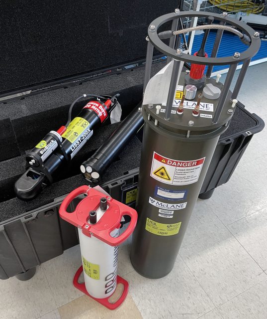
- Near-surface temperature and salinity: A Seabird SBE-37 CTD will be mounted on the “foot” of the five Coastal Profiler Mooring (CPM) buoys.
- Incident radiation: A Sea Bird OCR-507 multispectral radiometer will be mounted on the tower of the three Coastal Surface Mooring (CSM) buoys. This instrument will measure downwelling radiation per unit area.
- Surface wave spectra: A TriAxys Next Wave sensor will be added to the buoy well of all three CSMs. These sensors, which provide both non-directional and directional wave parameters, were previously deployed on only the Central CSM for the Pioneer NES.
- Turbidity: Seabird ECO triplet instruments with a secondary turbidity calibration on the optical backscatter channel will be deployed on the Near Surface Instrument Frame (NSIF) and seafloor Multi-Function Node (MFN) of the three CSMs.
- Nitrate: A glider with a Sea-Bird SUNA nitrate sensor will be deployed on the offshore “flux line”.
New Procurements
Several of the high-priority recommendations from the Innovations Labs that were deemed feasible for implementation required instrumentation that was not part of the OOI core. In this case, a formal procurement process is required (the process for replacing an obsolete sensor is similar). Four measurements required new instrument procurements: Near-surface velocity, phytoplankton imagery, particle size, and seafloor pressure. The procurement process for these instruments was initiated in November 2022.
The procurement process involves multiple steps of specification, information collection, review and approval before actual purchases are made. Among the first set of steps executed for the Pioneer MAB procurements were: consultation with a Focus Group of scientists external to the OOI, development of measurement specifications and revision of requirements as needed. The specifications were then used to create a solicitation of information from vendors through a broadly disseminated Request For Information (RFI). The RFI responses were reviewed by a selection committee composed of both internal and external subject matter experts, who evaluated instrument and vendor capabilities relative to performance specifications, technical feasibility, cost, and other factors. Additional steps included Design Reviews and Selection Reviews where the documentation of the process is presented to the Program Management Office and the NSF. After approval of vendor selection from the Review steps, orders were placed for the new equipment.
The Program is currently pursuing the procurement of four instrument classes, with 15 instances to be deployed at different locations within the Pioneer MAB Array (Table 1). Instrument locations include the buoy, Nearshore Instrument Frame (NSIF) and Multi-Function Node (MFN) on the Coastal Surface Moorings, and the buoy and buoyancy sphere of the Coastal Profiler Moorings.
Table 1: New Instrument Procurements for Pioneer MAB
| Measurement | OOI Code | Make/Model | Location | Instances |
| Near-surface velocity profile | ADCPU | Nortek Aquadopp profiler 1MHz | Coastal Profiler Mooring Sphere | 5 |
| Plankton Imaging | PLIMS | McLane Imaging Flow CytoBot | Coastal Surface Mooring Central site NSIF | 1 |
| Particle Size Analysis | PRTSZ | Sequoia LISST-200X | Coastal Surface Mooring NSIF and MFN | 6 |
| Seafloor Pressure | PRESF | RBR Quartz3Qplus | Coastal Surface Mooring MFN | 3 |
More information on the proposed relocation of the Pioneer Array to the Mid-Atlantic Bight is available here.
Read More
R/V Neil Armstrong in Drydock while OOI Team Onboard
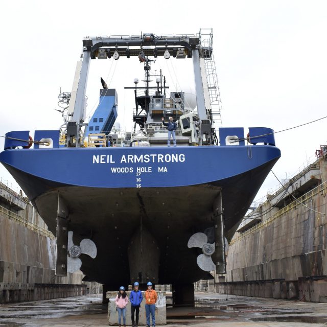
The fact that the R/V Neil Armstrong was out of the water on blocks at the Deytens Shipyard in North Charleston, SC, didn’t deter the Ocean Observatories Initiative (OOI) Coastal and Global Scale Node (CGSN) Team members from loading equipment and setting up laboratories for the first at-sea test deployment for the Coastal Pioneer Array in its new location in the Southern Mid-Atlantic Bight. Woods Hole Oceanographic Institution (WHOI) Port Engineer Hank Ayers helped make this dual operation possible. Ayers has been handling logistics for the Armstrong for 10 years. Over the course of time, he’s developed a knack for multi-tasking, and keeping on schedule and budget, while keeping the 238-foot Armstrong in tip top shape.
Looking at the Armstrong’s at-sea schedule, Ayers arranged for a regulatory drydock period prior to the Pioneer test deployment expedition near the array’s test deployment off the coast of Nags Head, NC. (See figure to right). Regulatory drydock checks are required about every two and a half years for inspections mandated by the US Coast Guard and the American Bureau of Shipping. While in drydock, the Armstrong underwent inspections of the propeller shaft, 17 sea chest valves were checked for condition and wear, the port and starboard anchor chains were replaced, and about 10 percent of the ship’s hull was repainted most of this along the waterline, where it is most susceptible to wear and marine growth, while other sections were touched-up as needed. Other regular maintenance tasks were also completed while the crew was in port.
[embed]https://vimeo.com/819612282[/embed]Ayers explained the complexity of getting a huge vessel that weighs 2641 tons with a 50-foot beam into drydock so the keel can be inspected. “The ship is steered into a big basin with a movable wall at one end. The goal is to have the ship land on top of blocks so when the water is pumped out, it will be securely in place. It’s a delicate process. There’s a ball that floats up at the bow when the ship is in the right position. Once aligned, the crew keeps the ship centered and in position. A diver is also in the basin to make sure that once the ship gets close to the blocks there are no problems down there. Once the ship is in place on the blocks, the water is drained out.”
The Armstrong was out of the water for 20 days. The Pioneer At-Sea Test team arrived on February 16 to begin the unusual process of mobilizing for the expedition while the ship was technically on land. The shipyard is equipped with huge cranes needed to load the 8000+ pound moorings onto the stern of the ship. Under normal operating conditions, the cranes on the ship would be used to load the equipment onboard.
Said CGSN Instrument Lead Jennifer Batryn who helped with the mobilization, ““It was definitely weird seeing the Armstrong out of the water. It’s a very different perspective than most people are used to seeing for the ship and was especially interesting to observe given OOI uses the Armstrong for a number of our cruises. Other than that, once we were on the ship while it was still in drydock, it really didn’t feel that much different. The ship was very stable and we went through the normal operations of getting the equipment onboard and ready for departure.“
Once loaded, some of the CGSN team headed home to Woods Hole Oceanographic Institution, while a team of nine WHOI engineers and scientists stayed onboard to execute the test deployments.
[media-caption path="https://oceanobservatories.org/wp-content/uploads/2023/04/DSC_0258-2-scaled.jpg" link="#"]Not a view many get to see! Armstrong’s Chief Engineer Pete Marczak waving from the stern and CGSN Team members Irene Duran, Jennifer Batryn, and Dee Emrich standing in the North Charleston, SC drydock give a good sense of the size of the RV Neil Armstrong below the waterline. Credit: Rebecca Travis © WHOI.[/media-caption]The process of refloating the ship commenced on February 21 with the filling of the drydock. It took about 6 hours and 134 million gallons of water to raise the Armstrong in the dock to sea level and ready for departure. The movable wall was taken out and the Armstrong maneuvered over to a nearby pier to continue to get ready for sea and OOI work.
Added Ayers, “The Armstrong is a beautiful, capable ship. When she’s out of the water, you get a sense of her size and capabilities. It’s always a wonderful sight.” And one that won’t happen for a while. Armstrong’s next scheduled drydock is in 2025, so for now, the ship is in good working order and ready to continue its job as a scientific workhorse.
[embed]https://vimeo.com/819618715[/embed]
Videos credit: Rebecca Travis © WHOI.
Read More