
Posts Tagged ‘RCA’
37-day RCA Cruise Met All Objectives and More
This summers’ Regional Cabled Array (RCA) 37-day expedition was one of the most complex of the seven annual Operations and Maintenance cruises to date. Not only was the expedition impacted by COVID restrictions, but it also included four Legs, a full contingent of engineers, scientists, students, and the Jason team, as well as coordinated ship operations with the R/V Thompson, the IT Integrity cable support ship, and the Ocean Exploration Trust ship the E/V Nautilus. However, thanks to the hard work of the RCA staff, and amazing support from the R/V Thompson (Captain Dave Vander Hoek) and ROV Jason teams, (Expedition Leads Ben Tradd and Mario Fernandez) the expedition was highly successful with the completion of all scheduled tasks…and more.
The expedition was led by Chief Scientists Mike Vardaro (Leg 1) and Orest Kawka (Legs 2-4), and Co-Chief Scientists James Tilley (Legs 1-3), Wendi Ruef (Leg 1 – this was the first time Ruef has sailed as a Co-Chief Scientist), Mike Vardaro (Leg 2), and Katie Bigham (Leg 4). Katie will receive her Ph.D. in 2022 from the University of Wellington, NZ. This cruise provided her a strong early career foundation for becoming a future Chief Scientist. James Tilley was the lead engineer and Larry Nielson led shore support.
COVID safety protocols significantly increased cruise complexities, which included the verification of full COVID vaccination status for all ship and science party members, ensuring that all participants sheltered-in-place, and the arrangement of COVID tests spanning both Washington and Oregon testing sites. The RCA team is highly appreciative of the exceptional support that the UW Marine Operations group provided to ensure our safety, the dynamics of crew changes, and modification of dock-side logistics in response to IT Integrity and E/V Nautilus operations.
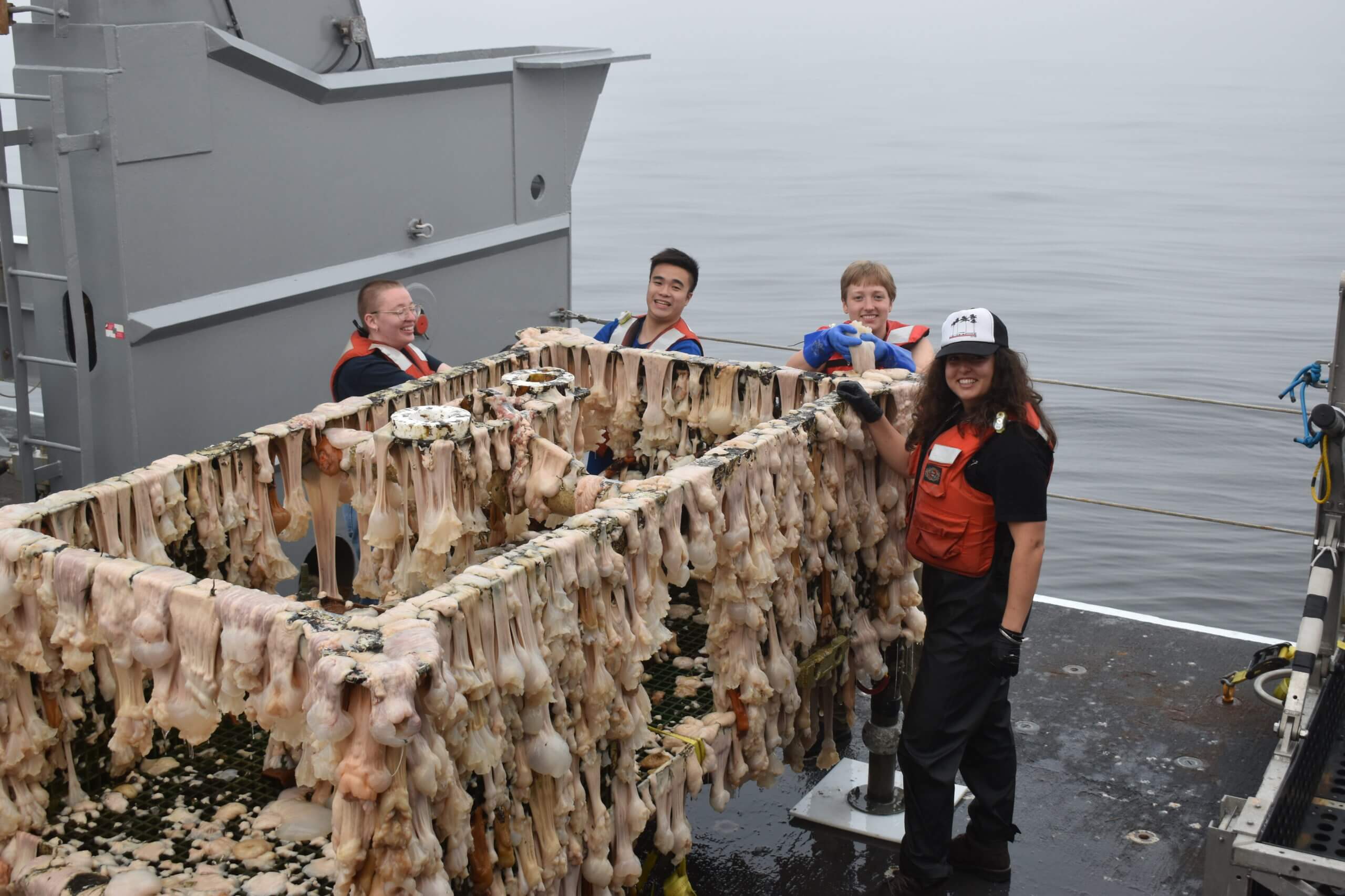
[media-caption path=”https://oceanobservatories.org/wp-content/uploads/2021/09/PD01A_20210821_084428_recovery-scaled-1.jpeg” link=”#”]The Slope Base Deep Profiler Mooring comes aboard the R/V Thompson. Credit: M. Elend, University of Washington, V21. [/media-caption]Highlights: During the four Legs, just over 200 RCA Core and PI instruments were recovered/deployed, the Platform Interface Assemblies and Science pods on all three Shallow Profiler Moorings were turned, Deep Profiler vehicles were turned at the Oregon Offshore and Axial Base sites, and the Deep Profiler mooring was turned at Slope Base. Of particular note, the southern cable line was repaired, resulting in the return of full operational status for Primary Nodes PN1C and PN1D, providing communications and data flow once again to/from the Oregon Offshore and Shelf sites.
Over the 37 days of staging, mobilization, and demobilization for the four Legs, twenty 48 ft trailers transported 394,000 pounds of RCA equipment to and from Seattle, WA and Newport, OR. Onboard staffing included twenty-one RCA scientists and engineers, 13 ROV Jason crew, 16 students, 1 postdoc, and an artist, as well as two research scientists. During the 30 at-sea days, including two to aid in the recovery of the Ocean Exploration Trust ROV Hercules and Argus vehicle from the Endeavour Segment of the Juan de Fuca Ridge, the R/V Thompson transited ~1775 miles, 49 Jason dives were completed traversing a total of~ 125,000 meters of the water column, seven CTD casts with water sampling were completed spanning maximum cast depths of 200 m to ~ 2900 m, and two EM302 bubble plume surveys were conducted over methane seep sites at Southern Hydrate Ridge and Pythias Oasis. Finally, a new, highly active methane seep area was discovered east of the novel Pythias Oasis vent site, which has been continuously venting since its discovery in 2014.
PN1B: During Legs 1 and 2, significant and dynamic coordination was required to ensure that the R/V Thompson and C/S Integrity operations (lead by APL Engineer Chuck McGuire) were tightly coupled and that shore cranes and trucks were in place for mobilization and demobilization of both the RCA cruise gear and that associated with the recovery-repair of Primary Node PN1B. Three dives (August 5: J2-1342, and August 10-11: J2- 1342, and J2-1354) were dedicated to disconnection of cables, preparation of PN1B for recovery, and recovery of a ½ frame deployed by the Integrity, which was utilized for installation of the recovery line. The R/V Thompson-ROV Jason operations went well. Although the replacement PN1B installation could not be completed, the cable Segments 2-3 were joined and then successfully installed on August 23 – reinstating power and communications to Primary Nodes PN1C and PN1D. Unfortunately, the Southern Hydrate Ridge site will remain offline until next year, when PN1B can be reinstalled. However, joining of the segments allowed 76% of the instruments to go live again that had been offline since August 2020, as well as the Shallow Profiler and Deep Profiler moorings and BEP at the Oregon Offshore site, and the BEP and other seafloor instruments at the Oregon Shelf site.
VISIONS’21: Once again, live streaming of video and updates on the cruise were provided on the interactiveoceans website as part of the UW- RCA VISIONS’21 engagement efforts and highlights were provided on Instagram and Twitter. The 16 undergraduates that participated on the cruise worked four-hour shifts in the ROV control van, they learned how to process and analyze CTD samples, and they helped with cleaning of recovered RCA equipment (a big hit). Their enthusiasm permeated the team and their hard work contributed significantly to the cruise. We were grateful to have a resident watercolor artist onboard who shared aspects of the cruise and seafloor and biological observations through her eyes. The students shared their experiences through blogs and for many it changed their lives – a few examples of their impressions:
I found this to be a once in a lifetime opportunity and [it] offered me a broader perspective of how much preparation and consideration goes into the planning and execution of the research projects being facilitated through the OOI VISION’s expedition. It opened my eyes to the full circle of science.
This has truly been one of the coolest experiences I’ve had …. after 4 quarters of zoom classes and online labs, I’ve been so happy to finally get a feel for oceanographic research out in the field and to work with the instruments I’ve been learning about for a year and a half.
As a kid, I watched documentaries about the deep sea and imagined myself descending into the depths with the camera, sometimes sitting in a cardboard box “submarine” that I made. Being here and getting to work in the Jason van feels like accomplishing some part of that dream, and I’m very grateful to have had the opportunity to come on this trip. I’ve also come away with a better idea of how data are collected at sea, and in speaking with the scientists onboard I’ve gained a better understanding of how one goes about getting into the field.
Externally Funded Projects: The 2021 program was also another successful field season for turning, and installation, and recovery of instrumentation, and for science programs funded outside of OOI. This work included:
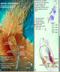
- The turning of NSF-funded CTDs at the ASHES hydrothermal field and at the Eastern Caldera sites, as well as installation of a new CTD at Central Caldera at the summit of Axial Seamount (W. Chadwick, Oregon State University – OCE 1928282 “Phase 2 of Enhancements to the OOI Cabled Array at Axial Seamount”). [1-day]
- The reinstallation of the University of Bremen-Germany-funded cabled overview multibeam sonar for imaging of all methane plumes at Southern Hydrate Ridge (G. Bohrmann and Y. Marcon -University of Bremen – Sonar monitoring of natural release of methane greenhouse gas from the seafloor – A contribution to the understanding of global change), the 4K camera, and turning of a CTD. [1-day]
- Installation of an NSF-funded new Pinnacle ADCP at the Central Caldera site to provide, for the first real-time, monitoring of currents throughout the entire ~1500 m water column (D. Manalang and D. Kelley, University of Washington – OCE 2129943 “RAPID: OOI-Industry Partnership to Install a Cabled 45 kHz ADCP at Axial Seamount Caldera”). This effort is in partnership with Teledyne Marine.
- Recovery of a NSF-funded self-calibrating pressure sensor at the geodetic-focused Central Caldera site (William Wilcock, University of Washington – OCE 1634103 – “A Rotating Tiltmeter for Marine Geodesy: Development and Testing at Axial Seamount on the Ocean Observatories Initiative Cabled Array”).
- A NSF-funded dive to complete site characterization, based on an ~ 1 m resolution bathymetry Sentry map, of the Pythias Oasis ridge. The dive focused on a “gully” that runs parallel to the ridge and s significant depression at the termination of the ridge (D. Kelley, University of Washington – OCE 1658201 “Collaborative Research: Pythia’s Oasis – Access to Deep Subduction Zone Fluids”). Pythias Oasis is venting fluids unlike any yet discovered in the world’s oceans. They are likely sourced at/near the plate boundary. Evidence of additional sites of seepage were discovered. [1-day]
- Three dives funded by the Bureau of Ocean Energy Management (D. Kelley, University of Washington – M21AC00009-00 “Arctic Marine Mineral Exploration – Ramen Laser Spectroscopy Validation”) at the ASHES hydrothermal field in support of the NASA InVADER program. Major and gas-tight vent fluids and several sulfide samples were recovered, and a couple microbial incubation experiments were deployed [1-day].
Recovery of the ROV Hercules and Argus Vehicle: On August 26th, the Ocean Exploration Trust ROVs Hercules and Argus became detached from the tether on the E/V Nautilus working east of the Main Endeavour Field (MEF) on the Endeavour Segment of the Juan de Fuca Ridge (2220 m). After a flurry of phone calls and Zoom meetings, the R/V Thompson, RCA, and OET (Expedition Lead Allison Fundis) teams came together for a community effort to recover the vehicles. The R/V Thompson transited ~ 10 hrs north to the MEF where there were two Jason dives to facilitate the September 2 successful recovery of the vehicles back onboard the E/V Nautilus. The effort required extension of the RCA cruise by two days, and it was a weary team that pulled back into Newport on September 3. Demobilization was complete on September 4th.
Read More
Seismic Hazards Around the Globe: A Visualization Tool to Bring RCA Data into the Classroom
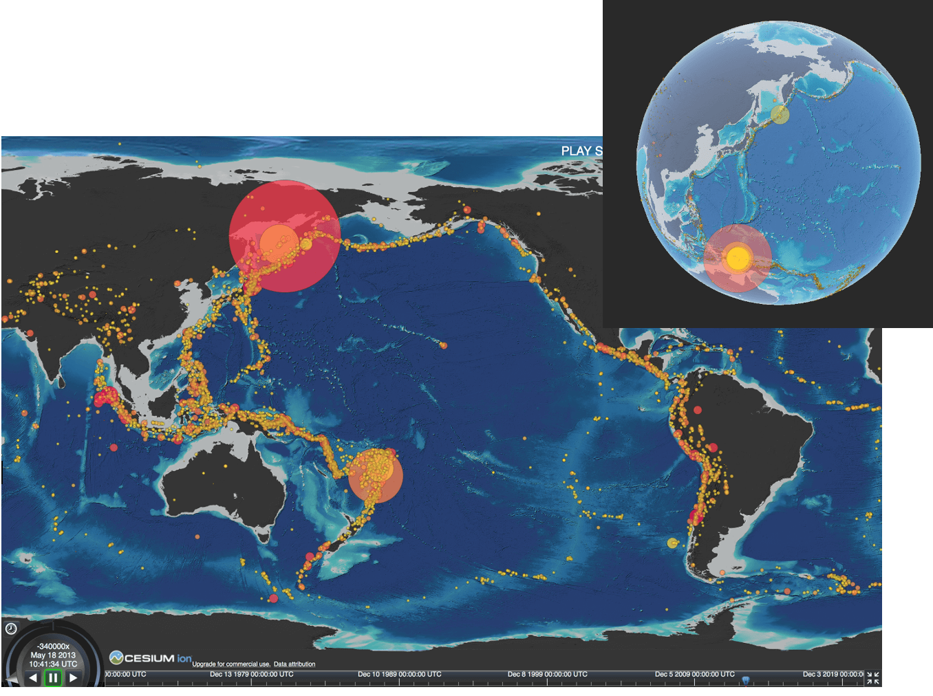
As part of the continuing University of Washington engagement effort, and in preparation for the new National Science Foundation K12 education award focused on bringing OOI data into the classroom, Kelley collaborated with the Center for Environmental Visualization within the School of Oceanography to generate an earthquake exploration tool focused on seismic events within the global oceans from 1970 to present. We anticipate that one of the curriculum modules developed for the K12 program will be focused on geohazards, with an emphasis on the Cascadia Subduction Zone within the context of the “ring of fire.” A video of this animation is hosted on interactive oceans and a direct link to the developmental site is provided above. The animation will be used in a Queens College physical geology class this next year that has 150 students (Dr. Dax Soule). This effort is also in preparation for completing a similar visualization focused on Axial Seamount and Regional Cabled Array seismic data.
The data sets used for this effort include a map centered on the Pacific Ocean that shows the distribution of earthquakes of magnitude ≥6 in the U.S. Geological Survey catalog from 1970 through 2021. The topographic dataset is licensed under Creative Commons CC BY-4.0. The data were formatted to match the JSON format recommended for use of global visualization using the ‘Cesium’ interactive virtual earth viewer promoted within its 3D geospatial visualization for the web toolset. The Cesium JavaScript API was utilized to implement algorithms for procedural color determination based on magnitude and hypocenter point radius animation based on the date-time of the earthquake event. The resultant animation is highly interactive, allowing the user to choose a 3D global view or a flat view, and viewing speeds of 1-8 times. In addition, the field of view can be changed to move to a specific area of interest and includes zoom capabilities. A sliding time bar allows the user to focus in on particular items of interest.
Read More
RCA Visions 21 Departs for 37-day Expedition
The University of Washington Regional Cabled Array Team left Seattle, Washington on 30 July for its annual Operations and Maintenance (O&M) Expedition for the cabled component of the National Science Foundations’ Ocean Observatories Initiative (OOI), through September 4, 2021. This 37-day cruise is on the global class research ship the R/V Thomas G. Thompson, operated by the University of Washington, which is hosting the remotely operated vehicle (ROV) Jason, operated by Woods Hole Oceanographic Institution.
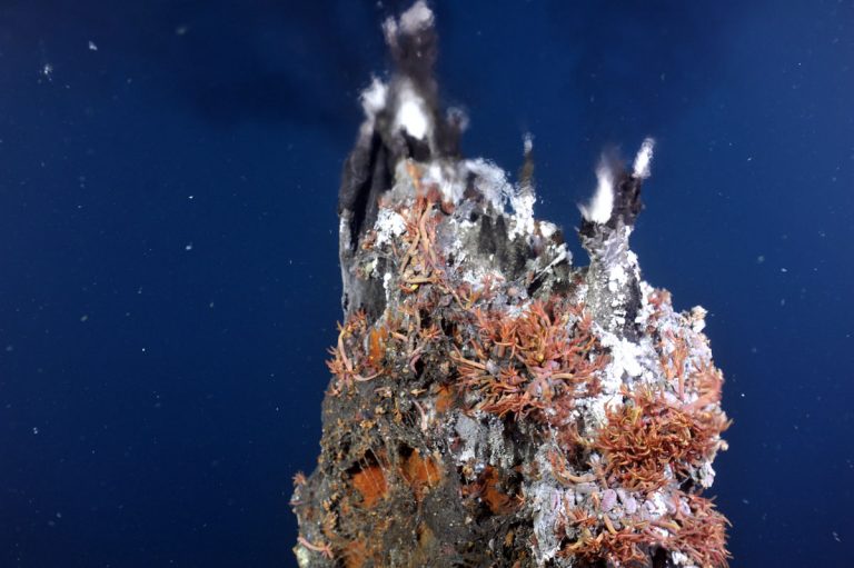
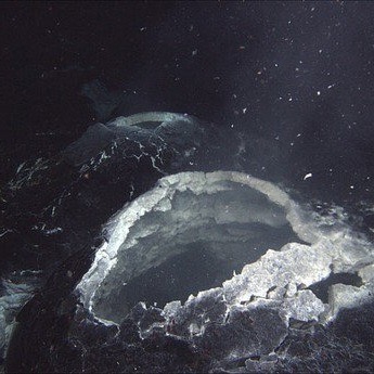
[media-caption path="https://oceanobservatories.org/wp-content/uploads/2021/07/J1265_20200808_0232_CAMDSB303_recover-copy-2.jpeg" link="#"]ROV Jason breaks the surface above the most active volcano off the WA-OR coast. Credit: UW/NSF-OOI/WHOI. V20.[/media-caption]The expedition can be followed through live video feeds from sea, daily updates, and stunning imagery. During the cruise, virtual visitors will be able to directly observe parts of the seafloor rarely seen by humans – the most active submarine volcano off our coast ‘Axial Seamount’ located about 300 miles offshore and nearly a mile beneath the oceans’ surface. Here virtual visitors can witness one of the most extreme environments on Earth – underwater 700°F hot springs teaming with life that thrives on volcanic gases and lives in the complete darkness of the deep sea. The team will also visit the Cascadia Margin, spending time at Southern Hydrate Ridge where methane ice deposits are exposed on the seafloor with areas of dense microbial mats, and at shallower sites that are some of the most biologically productive areas in the world’s ocean.
[media-caption path="https://oceanobservatories.org/wp-content/uploads/2021/07/overview.flow_.mosquito.sm_.r1772_03229-scaled.jpg" link="#"]A “Mosquito” flow meter (far left) and osmotic fluid sampler (far right) installed on microbial mats Southern Hydrate Ridge. Photo credit: NSF-OOI/UW/CSSF; Dive R1772; V14.[/media-caption]The Regional Cabled Array (RCA) team is excited to get underway and looking forward to being out in the Pacific Ocean again. This is an immense logistics operation with ~ 20 trucks transporting >130,000 lbs of gear to Newport, Oregon in support of highly complex at-sea operations that have required months of planning, and testing of gear to be installed. During the cruise, the ROV will deploy and recover a diverse array of more than 200 instruments, several small seafloor substations that provide power and communications to instruments on the seafloor and on moorings that span depths of 2900 m (9500 ft) to 80 m (260 ft) beneath the oceans’ surface. In addition, several novel, externally funded instruments developed by scientists in the US and Germany will be installed.
This year, the RCA Team will be joined by 19 students sailing as part of the UW’s educational mission (VISIONS’21). The students will be distributed over the four legs of the O&M Expedition. The VISIONS program has allowed >160 students to participate in this at-sea experiential learning program.
Virtual visitors will have the opportunity to share in the students’ wonder and excitement through their blogs and daily updates here. Be sure to bookmark this site and check back often to share in what promises to be a life-changing experience for many students. Share in their adventure!
Article by Deb Kelley, Principal Investigator for the Regional Cabled Array
Read MoreFollowing the Eruption and Evolution of a Submarine Volcano Live
An outstanding RCA science success has been the unprecedented insights into submarine volcanism (which accounts for >70% of the volcanism on Earth) through cabled instrumentation at Axial Seamount [1-5; 10-22].
Read MoreNew Research to Help Scientists Better Predict Underwater Volcanic Eruptions
A team of scientists studying last year’s eruption of Axial Seamount now says that the undersea volcano some 250 miles off the Oregon coast gave off clear signals hours before the eruption.
Read More