
Posts Tagged ‘Woods Hole Oceanographic Institution’
WHOI Science Stroll
Come join us for a fun-filled, family-friendly celebration of the cutting-edge ocean science happening at Woods Hole Oceanographic Institution (WHOI) in Woods Hole, MA. This annual event offers interactive activities and engaging exhibits from Woods Hole’s six major science institutions, the U.S. Coast Guard, and a variety of local nonprofits dedicated to environmental and educational outreach.
OOI will be there with a booth — stop by and say hello! We’d love to chat and share what we’re up to.
Read MoreNational Science Foundation Renews OOI for Another Five Years
The National Science Foundation (NSF) announced that it has awarded a coalition of academic and oceanographic research organizations a second, five-year contract to operate and maintain the Ocean Observatories Initiative (OOI). The coalition, led by the Woods Hole Oceanographic Institution (WHOI), and including the University of Washington (UW) and Oregon State University (OSU), will continue operations of the OOI, a science-driven ocean observing network that delivers real-time data to address critical science questions regarding the world’s oceans.
WHOI has led the operations and management aspects of the OOI since 2018 and will continue to serve as the home for the next five years of the OOI Project Management Office, led by Principal Investigator James B. Edson and Sr. Program Manager Paul Matthias.
The OOI collects and serves measurements from more than 900 autonomous instruments on the seafloor and on moored and free-swimming platforms that are serviced during regular, ship-based expeditions to the array sites. Data from each instrument are transmitted to shore and are freely available to users worldwide, including scientists, policy experts, decision-makers, educators, and the public.
Under this new $220 M investment, each institution will continue to operate and maintain the portion of OOI assets for which it is currently responsible: WHOI will operate the Pioneer Array in the mid-Atlantic Bight off the North Carolina coast, subject to environmental permitting, and the Global Arrays in the Irminger Sea off the southern tip of Greenland and at Station Papa in the Gulf of Alaska; UW will operate the Regional Cabled Array that extends across the Juan de Fuca tectonic plate and through the overlying ocean; and OSU will operate the Endurance Array off the coast of Washington and Oregon. OSU also houses and operates OOI’s Data Center that ingests and delivers all OOI data.
“OOI has proven to be an exceedingly valuable source of information about the ocean,” said NSF Program Officer for OOI George Voulgaris. “Its freely available data are contributing to better understanding of ocean processes and how the ocean is changing. Scientists are using OOI data as the source of cutting-edge scientific discoveries—everything from getting close to predicting underwater volcanic eruptions to changing ocean circulation patterns that have real life implications for weather and fishing patterns. OOI data also are serving as inspiration for students in the classroom, who are excited about learning about the ocean with access to real-time ocean data. We at NSF are proud of our continued investment in making these data available.”
“WHOI is honored to have been selected to continue the mission of the OOI, which is providing valuable ocean data at a time when it is critically needed,” said Peter de Menocal, President and Director of the Woods Hole Oceanographic Institution. “The continued extreme weather events reinforce the importance of this ocean monitoring program to provide science-based data that is accessible to researchers, modelers, agencies, and the public, and we look forward to being part of the continued scientific advancements from this transformational program in the years ahead.”
The Project Management Office at WHOI collaborates with NSF to provide high-level oversight and financial management of the project. In addition, the office coordinates with partner institutions to establish annual priorities for each of the arrays individually and for the network. “The WHOI team and our partners at UW and OSU have learned a great deal over the past five years and are grateful that our efforts to perfect OOI and its data delivery system have been recognized,” said WHOI Senior Scientist Jim Edson, lead principal investigator on the OOI. “We look forward to the next five years where we can continue to perfect our collection and serving of data, while encouraging its increased use and collaboration among ocean scientists funded by NSF and other agencies.”
——————————————
About the Ocean Observatories Initiative
The Ocean Observatories Initiative is a science-driven ocean observing network that delivers real-time data from more than 900 instruments to address critical science questions regarding the world’s oceans. The National Science Foundation has funded the OOI, under Cooperative Agreement No. 1743430, to encourage scientific investigation. OOI data are freely available online to anyone with an Internet connection.
The U.S. National Science Foundation is an independent federal agency that supports science and engineering in all 50 states and U.S. territories.
Any opinions, findings, and conclusions or recommendations expressed in this material are those of the author(s) and do not necessarily reflect the views of the National Science Foundation.
Read More
Science Team Heads to Blustery Irminger Sea
Ten scientists from Woods Hole Oceanographic Institution (WHOI) will board the R/V Neil Armstrong on 8 August 2020 for about a month-long expedition to OOI’s Irminger Sea Array. The journey includes an eight-day transit to reach the array, where they will recover and replace ocean observing equipment that has ridden out arduous conditions in a region known for intense winter wind events (peak speeds of 50-55 knots).
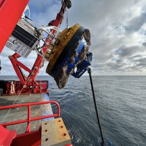
[media-caption path ="https://oceanobservatories.org/wp-content/uploads/2020/08/Irminger-Deck-Plan-small-scaled.jpg" link="#" title="Iminger Deck] Aerial view of the R/VNeil Armstrong deck with equipment loaded for an OOI Irminger Sea Array service cruise. Credit: Drone footage by James Kuo © Woods Hole Oceanographic Institution[/media-caption]Iceland is separated from the east coast of Greenland by the Denmark Strait, roughly a distance of some 250 miles. The Irminger Sea is south of the strait, stretching from Iceland down to the latitude of Cape Farewell at Greenland’s southern tip. This region is important to the Atlantic Ocean circulation and sensitive to global climate change.
Supported by wind power and solar cells, the Irminger Sea Array consists of moorings that serve as home for sensors that measure air-sea fluxes of heat, moisture and momentum, and physical, biological and chemical properties throughout the water column. The observations of the moorings are enhanced by open-ocean gliders that sample within and around the triangular array. The subsurface mooring data is also collected by the gliders via acoustic modem. The gliders then relay the collected data, glider sampling and mooring data, to shore via satellite telemetry each time they surface. Gliders also sample the upper water column near the Apex Profiler Mooring to complement the moored profiler data and extend coverage to the air-sea interface.
This month-long expedition is the seventh time the OOI team has traveled to the array, specifically to replace and repair equipment that is vital to maintaining a continuous flow of data from this important site.
“This is a difficult region to sustain surface observations, yet such observations are critical to improving our understanding of air-sea exchanges and deep convection that drives the Atlantic overturning circulation” said Al Plueddemann, project scientist for the OOI Coastal and Global Scale Nodes (CGSN).
WHOI Research Scientist Sebastien Bigorre will serve as the chief scientist for the expedition.
COVID Complications
The scientific party went into a 14-day quarantine on 21 July to ensure that everyone could safely board the ship. They were tested for COVID-19 prior to quarantine and will be tested again prior to departure. Masks and social distancing will be practiced onboard until another two-week period of health is achieved. At that point, mask wearing may be loosened as the scientific team and crew members will, in effect, be their own social bubble as they live, work, and share the space of the 238 foot-long vessel.
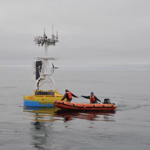
[media-caption path="https://oceanobservatories.org/wp-content/uploads/2020/08/DSC_0016_allison-scaled.jpeg" link="#" title="crew deploys a near surface instrument frame to the array"]During a past expedition to the Irminger Sea Array, the crew deploys a near surface instrument frame to the array. Credit: Alison Heater © Woods Hole Oceanographic Institution[/media-caption]Explained Derek Buffitt, program manager for the Coastal and Global Scale Nodes, operated from Woods Hole Oceanographic Institution, which includes oversight of the Irminger Sea Array, “COVID-19 created plenty of new logistical challenges for an expedition of this length and distance. We had to address contingencies such as what to do if someone presented COVID symptoms while at sea. WHOI’s marine operations office, working with agents and government representatives, confirmed health and safety protocols within the foreign ports along the planned vessel track. This was to ensure our personnel could receive the care needed in an emergency and in a timely manner.”
Such contingencies were necessary steps, in addition to many months of preparation, to ensure the equipment to be deployed is ready, tested, and packaged for transporting to the ship.
Watch this space, and social media, as we follow along on this important expedition.
Read More