
Archive for May 2023
Latest Version of Data Explorer Launched May 30
OOI’s Data Science Team, working with Axiom Data Science, announced additional improvements to OOI’s data access and visualization tool, Data Explorer will publicly launch on May 30, 2023. The latest Data Explorer, version 1.5, includes a significant expansion of data availability, updates to a viewer for underway still images, and introduces a beta version of real-time streaming for cabled instruments. Version 1.5 offers new scientific data for Autonomous Underwater Vehicles (AUV) and Bio-Acoustic Sonar (ZPLS) instruments and Principal Investigator-added instrument data are now available on the site. Visitors to the site will experience optimization and new viewing capabilities for still and animated images. Additionally, data are streamed in real-time by the second for cabled instruments in the Regional Cabled Array, giving users the most up-to-date information available.
“A great deal of effort goes on behind-the-scenes to make Data Explorer be responsive to users’ needs and provide seamless, quick access to data,” explained Jeffrey Glatstein, Senior Manager of Cyberinfrastructure and OOI Data Delivery Lead at Woods Hole Oceanographic Institution. “We are grateful to our team and the developers at Axiom who continually make this already great tool, even better.”
Details about the new features are included in the following:
New Features
ZPLS instrument data will now be online for more locations, including the Coastal (Endurance) and Global Arrays (Argentine Basin). This is the first time this type of OOI bioacoustics sonar data have been available in an interactive visualization. This version addressed feedback received from subject matter experts to improve the data charts, including respecting time selections among sonar frequencies, changing variable names, and addresses frequency sorting. Other technical fixes have been made to the backend in response to users’ suggestions, which will help make these data more accessible.
[media-caption path="https://oceanobservatories.org/wp-content/uploads/2023/05/1_1.5_zpls.jpg" link="#"]An example echogram from the bioacoustics sonar instrument on the Coastal Endurance array. The bio-acoustic sonar measures acoustic signals of plankton and zooplankton using sound waves which bounce off organisms back towards the sensor in a phenomenon known as “backscatter.”[/media-caption] [media-caption path="https://oceanobservatories.org/wp-content/uploads/2023/05/2_1.5_auv.jpg" link="#"]An example of interactive AUV data at the Coastal Pioneer Array in the Data Explorer. The travel trajectory of the AUV across the shelf-break is shown in the map. Data collected by the instrument as it dives from the sea surface to a maximum depth of 600m is shown in the chart on the right. Users can visualize data in 3-D across the water column in the lower interactive chart.[/media-caption]A media server will now be up and running on Data Explorer. In this version, updates have been made to improve the performance of the still image viewer. All image collections are shown in a Grid view which makes seeing what is available easier. Camera metadata is now available via a more information tab. Images will also be available on the pages included in time series. Images will also be available as a single image or in animation viewer. Full size images are presented with an image scale and available for download.
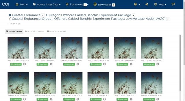
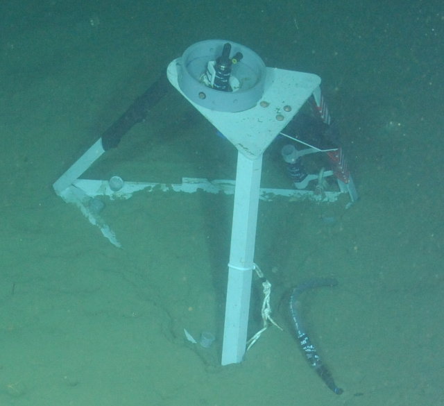
[media-caption path="https://oceanobservatories.org/wp-content/uploads/2023/05/3_1.5_image-viewer.jpg" link="#"]Cameras are attached to instruments on the cabled infrastructure of the OOI Regional Cabled Array. These long-term imagery records are now available in the Data Explorer for viewing and download to help understand life in deep water and coastal environments. The camera at Endurance Offshore is designed to look at the seafloor in general, observing animal activity, sediment transport, detritus falls, and bioturbation.[/media-caption] [media-caption path="https://oceanobservatories.org/wp-content/uploads/2023/05/4_1.5_image-viewer.jpg" link="#"]The media viewer in the Data Explorer allows users to pan and expand images, select images across a timeseries, view camera metadata, download images, and animate images across time.[/media-caption]Another added beta media feature is real-time streaming of Cabled Array instrument data. The design of this function is meant to be user-friendly. A Grid view shows available real-time streaming instruments. A Single view shows a real-time streaming chart, with data from the last 24 hours. These features are available from Data Explorer’s landing page with further explanations of what data are available and when.
Added Glatstein, “We invite all OOI data users to try out these new components and continue to provide us feedback. We are particularly eager to hear the community’s response to the beta version of the media server so we can tweak that as needed.”
[media-caption path="https://oceanobservatories.org/wp-content/uploads/2023/05/5_1.5_real-time.jpg" link="#"]An example of real-time streaming data now available for instruments on the Regional Cabled Array. This network of >100 cabled instruments and instrumented moorings transmit data to shore in real-time via fiber optic technology. Users can view and interact with new data every second as it is streamed from the deep ocean to shore.[/media-caption]
Read More
Update on RCA Broadband Hydrophone Data Availability, File Formats, and Directory Structure
As part of continuing OOI data process improvements, the RCA Data and OOI Software Development Teams have been working closely to expand data availability and improve data file consistency for six Broadband Hydrophones (HYDBBs) located at Axial Base (2), Slope Base (2), and Oregon Offshore (1) and Shelf (1) sites. Additional details are available on these study sites and instruments at these links.
A system update will go live at 17:00 UTC June 7, 2023 and will affect all HYDBB data posted on the Raw Data Archive server after that date. In the near future, the updates will also be applied to historical HYDBB files previously posted on the Raw Data.
OOI HYDBB data are currently provided to the public on the OOI Raw Data Archive server as MiniSEED-formatted files (extension “.mseed”). This lossless, compressed format is a subset of the Standard for the Exchange of Earthquake Data (SEED) that is in extensive use for archiving and serving seismological data (see IRIS). The HYDBB MiniSEED files are served on the Raw Data Archive in daily subdirectories organized by year and month for each of the sites:
- Axial Seamount – Axial Base
- Continental Margin – Slope Base
- Continental Margin – Oregon Offshore
- Continental Margin – Oregon Shelf
Once the system update goes live on June 7, all HYDBB data posted on the Raw Data Archive server after this date will have the following enhancements:
- Currently, only HYDBB data arriving at the OOI data repository in near real-time are provided to the public in the daily subdirectories, updated at nominal 5-min intervals. After the system update, data arriving at the OOI repository after Navy review will also be made available on the Raw Data Archive. These delayed and previously publicly unavailable data will be provided as analogously named MiniSEED datafiles but in separate subdirectories named “addendum” under each daily directory.
- Each individual MiniSEED file will include HYDBB data over fixed 5 min timespans, starting at 00:00 UTC and repeated at subsequent 5 min intervals (beginning at 00:05, 00:10 UTC, etc.). If no data are available for a specific 5 min timespan, the datafile will not be created. Any gaps in the data stream during each 5 min timespan are accounted for by the use of the multi-trace extension of the MiniSEED file format construct, which allows multiple temporal segments within a single file. Previously, each HYDBB file on the Raw Data Archive contained only a single continuous trace of data. An example Python toolbox for accessing/processing such MiniSEED data is available, with additional information on the ObsPy open-source project here.
This change in file construction will allow for more efficient access and delivery of HYDBB data, particularly when there are small and frequent gaps in the data streams which can lead to excessive file fragmentation, as was often the case with these data before this system update.
If you have any questions, please contact the OOI HelpDesk or post your question on the public OOI Discourse Forum.
Read More
OOI Data to be Archived by NOAA’s National Centers for Environmental Information
NOAA’s National Centers for Environmental Information (NCEI) and the Woods Hole Oceanographic Institution (WHOI) established a Cooperative Research and Development Agreement (CRADA) to share high-quality oceanic data collected from the National Science Foundation (NSF)-funded Ocean Observatories Initiative’s instrument arrays. The goal of the partnership is to archive and deliver the initiative’s data for continued research on ocean processes.
“WHOI is pleased to be working with NCEI for the long-term preservation of data produced by the Ocean Observatories Initiative” said Jeffrey Glatstein, Senior Manager of Cyberinfrastructure at WHOI. “The initiative is a science-driven ocean observing network that delivers real-time data from more than 900 instruments to address critical science questions regarding the world’s oceans. Given the long-term timeframe of the program and the impact of having a continual record of measurements, the archiving of this data is a significant step in making these data available for researchers in the future.”
“Under this partnership agreement, NOAA expects to be provided at least 30 years of high-quality oceanographic data produced by the Ocean Observatories Initiative, commissioned in 2017, for preservation and stewardship” said Jason Cooper, NCEI’s Archivist.
NCEI will be responsible for acquiring and managing the required IT storage for the data that WHOI will provide, which is expected to amount to roughly seven terabytes. NCEI will ensure that the metadata associated with the data are up to federal and international standards such as those regarding storage, preservation, and accessibility. In addition to providing the data that have been collected to date, the agreement also calls for WHOI to transfer an additional 710 gigabytes of data annually for the next ten years.
WHOI is an independent, non-profit organization dedicated to ocean research, exploration, and education. WHOI and their Oregon State University (OSU) and University of Washington (UW) partners designed and now manage the instrument arrays involved in this CRADA partnership that collect chemical, biological, geophysical, and physical measurements in the global ocean from below the seafloor to the surface.
The CRADA allows NCEI and WHOI to achieve their common goal of supporting research related to ocean and atmospheric processes by sharing their findings with the scientific community, policymakers, and the general public.
Read More
Tenth Turn of Global Station Papa Array
The Global Station Papa Array is in the Gulf of Alaska at a critical region of the northeast Pacific Ocean. The region is extremely vulnerable to ocean acidification, has a productive fishery, low eddy variability, and is impacted by the Pacific Decadal Oscillation, often described as the as a long-lived El Niño-like pattern of Pacific climate variability.
A team of 10 scientists and engineers from Woods Hole Oceanographic Institution (WHOI) and the University of Washington will be onboard the R/V Sikuliaq for 15 days in May to ensure that this Array continues to provide data from this important region. The team will deploy three OOI moorings, two open ocean gliders, and one profiling glider. A waverider mooring, which measures wave height and direction, will be deployed for the University of Washington. During the expedition, the team also will be conducting water sampling during recovery and deployments, and sampling while underway for instrument calibration purposes.
Located next to the NOAA Pacific Marine Environmental Laboratory (PMEL) Surface Buoy and deep-water sound buoy, the Station Papa Array is an important contributor to a cooperatively studied region. The University of Washington operates a waverider mooring near the buoys. The US Coast Guard’s Research Vessel John P. Tully regularly collects data in the region. And the Department of Fisheries in Canada operates a glider line in the region.
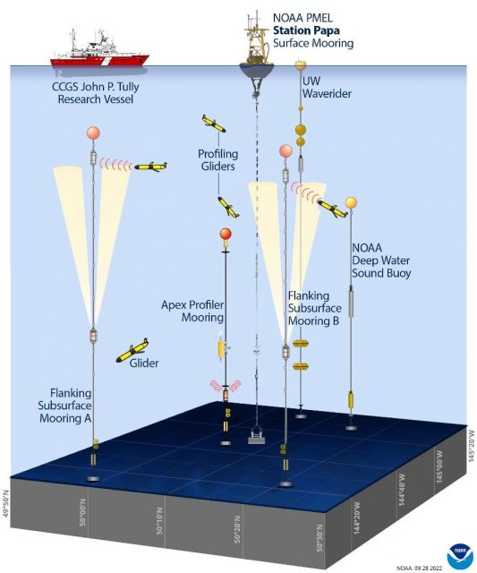
[media-caption path="https://oceanobservatories.org/wp-content/uploads/2023/05/CGSN_Papa-10_IRR_Presentation_2023-05-01.jpg" link="#"]The Global Station Papa Array and complementary components. Credit Sarah Battle, NOAA/PMEL, adapted from OOI.[/media-caption]This annual spring “turn” of the Array is no small undertaking. A successful turn requires months of equipment preparation and testing. After all instrumentation has been cleared to go, it is then shipped from Woods Hole Oceanographic Institution to Seward Alaska, where it is again tested as the moorings are assembled for loading onboard the Sikuliaq. Loading is complex, as well. All deck space is fully utilized and when loading is complete, 106,340 pounds of equipment will have been moved onto the ship.
“We have a good, experienced team and the Sikuliaq captain and crew couldn’t be better, “said Kris Newhall, Senior Project Manager at WHOI and Chief Scientist for Station Papa 10. “Our work in this region is really important for the data being generated are helping scientists to understand primary production, marine heat waves, and a whole lot more.”
Regular updates from the Station Papa 10 expedition will be reported here. Bookmark the page and follow along.
Read MoreOOI Receives SOLAS Endorsement
The Surface Ocean – Lower Atmosphere Study (SOLAS) endorsed the Ocean Observatories Initiative (OOI) as one of its Integrated Atmosphere-Ocean Time Series Stations at the forefront of SOLAS science.
SOLAS is an international research initiative that aims to understand the key biogeochemical-physical interactions and feedbacks between the ocean and atmosphere, and how this coupled system affects and is affected by climate and global change. In operation since 2004, SOLAS has 1227 members worldwide, and 31 scientific networks with members from 14 nations.
OOI data directly address the SOLAS core themes on ‘Greenhouse gases and the oceans’, ‘Air-sea interface and flux of mass and energy’, ‘Atmospheric deposition and ocean biogeochemistry’ and ‘Ocean biogeochemical control on atmospheric chemistry’, as well as the cross-cutting themes on ‘Polar oceans’, ‘Upwelling systems’ and ‘Climate intervention’.
The designation as one of SOLAS’s time-series stations benefits both OOI and SOLAS, as well as the broader ocean science community. The endorsement provides OOI with the opportunity to provide input to the development, planning, and implementation of SOLAS and closer links to other international programs. The interconnection provides scientific value through contextual links and collaborative opportunities as well as the potential for the development of standardized measurement methods and protocols, facilitating quality control and data sharing.
“We are pleased to have been endorsed by SOLAS’ Scientific Steering Committee, which will continue to broaden the use of OOI data to answer critical ocean-related questions,” said Jim Edson, Principal Investigator of OOI’s Program Office. “We are particularly excited about the possibility of greater collaboration and continued implementation of best practices within the international ocean observing community.”
Read More