
Posts by ooistaff
New View of Biological Carbon Pump
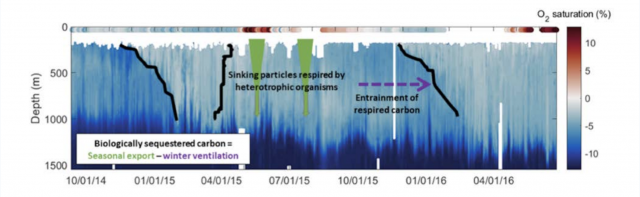
The ocean’s biological carbon pump plays an important role in the global carbon cycle. Using OOI data from the Global Irminger Sea Array, researchers discovered that much of the organic carbon exported from the surface is ventilated back to the atmosphere, rather than being sequestered long-term as had been previously thought.
Read MoreRCA Technical Wizards: The Saga of Repairing an RCA Primary Node
Chuck McGuire and Larry Nielson were able to take a cabled power and communications substation that sat inoperable on the dark, cold seafloor of the Pacific for two years and make it work again. The odds were against them. There’s usually less than a 50-50 chance to make a complex technology operational again after this length of inactivity – inactivity compounded by the extreme pressure, cold temperature, and biofouling that occurs on the bottom of the Pacific Ocean. But these two engineering geniuses succeeded in repairing, rebuilding, and ultimately reconnecting Primary Node 1B (PN1B), which provides power to the Southern Hydrate Ridge portion of OOI’s Regional Cabled Array (RCA).
[embed]https://vimeo.com/user110037220/pn1b[/embed]It was an arduous, complicated journey, fraught with delays outside of the engineers’ control. The recovery, repair, and reinstallation took two years to complete. We share some of the highlights below for they illustrate the many challenges of operating seafloor cable infrastructure on an active tectonic plate in the Pacific Ocean.
Chuck McGuire, a senior principal engineer, is the chief engineer for the RCA and principal investigator for the engineering portion of the RCA, which is conducted at the University of Washington’s Applied Physics Laboratory (APL). Larry Nielson is a field engineer three at APL. They have been working on the RCA project since its inception in 2009 (Construction and deployment began in 2013).
When PN1B failed in 2020, the duo was stymied at first. They had to call in a variety of people with different skills to recover, rebuild, and redeploy it.
“Restoration of the PN1B is really a testament to the engineering that went into these nodes, which are good and work well under very harsh conditions, “explained McGuire. The Primary Nodes were designed and built by L3 Maripro with oversight by the APL Engineering team.
A Cable Fault Causes Power Loss
The saga began during RCA’s annual maintenance expedition in summer 2020. Everything was smooth sailing until suddenly the science team aboard the R/V Thomas G. Thompson learned of a cable fault on the southern cable line, which had shorted out. McGuire and team instantly went into troubleshooting mode and determined that the problem was in PN1B, which powers the Southern Hydrate Ridge section of the 900 kilometers of cable that comprise the RCA.
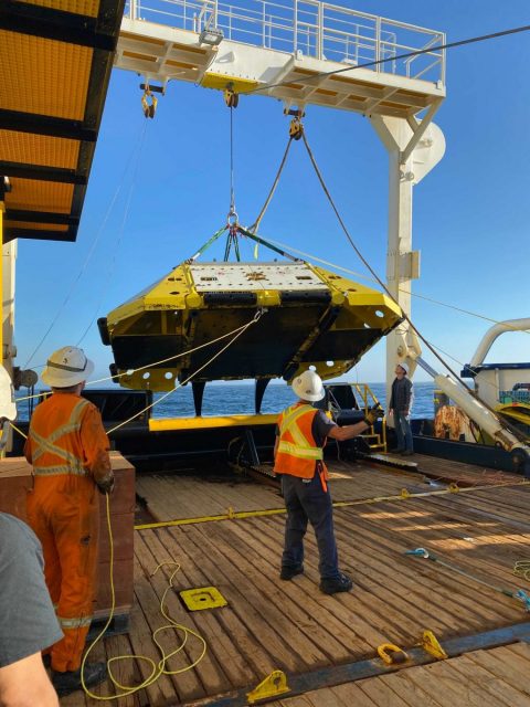
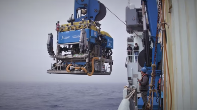
[media-caption path="https://oceanobservatories.org/wp-content/uploads/2023/03/202108-Recovery-of-Failed-PN1B-scaled.jpg" link="#"]Recovery of failed PN1B. Credit: NSF/OOI/UW.[/media-caption]Luckily, they were able to divert the ship, the R/V Thomas G. Thompson, to the PN1B location to investigate. McGuire was on shore at the Shore Station in Oregon where he could troubleshoot the power system. McGuire worked with a team onboard to use the Remotely Operated Vehicle (ROV) Jason, operated by the National Deep Submergence Laboratory of the Woods Hole Oceanographic Institution, to unplug and plug back in the science interface assembly (SIA) that provides power and communication to secondary infrastructure on the array (e.g. extension cables, junction boxes, instruments, and moorings). The SIA was attached to and powered by PN1B. The SIA wasn’t the cause of the short, so the next step was a visual inspection of the cable with the ROV, tracing the cables back from the node to see if there was any external aggression or damage to that cable. None was seen. The next step was to determine where the power was lost. By controlling the power from the Shore Station and sending “tones” (an oscillating frequency) down the cable, they were able to isolate the affected area. They determined that the PN1B was no longer transmitting any power to the southern cable line running east of the node.
McGuire and Nielson set to figuring out how to replace the damaged node with a spare. A specialized cable ship would be required. A request for proposal was released and the cable ship IT Integrity was secured.
With a cable ship lined up, the engineering team set about reconfiguring the Primary Node and a replacement SIA, which would be plugged into PN1B when both were back on the seafloor. The assembly was complicated and required reconfiguration of all the optics in the SIA’s interior. “Larry was able to get the SIA unassembled and rigged up in a way that made it possible for me to go in and remove and replace the components that needed to be replaced,” explained McGuire. “All of this was unexpected work, which took time, and there was much aggravation. But Larry had some amazing solutions to some interesting rigging problems.”
The two engineers had to rely on their experience to tear down the SIA and then reconstruct it. Their challenge included having to create specialized tools to get into extremely tight spaces. McGuire likened the work to repairing a car engine, where one slowly takes things off, working through the engine until finding the problem. The difference between the Primary Node and a car, however, was that spare parts to fix any issues found weren’t readily available and would have to be manufactured if needed. Here, again, the skill, experience, and tenacity of this duo were called into play. After taking the node apart and putting it back together again, they are now experts.
Their work was driven by a tight schedule needed to get the node and SIA ready for the next RCA recovery and deployment cruise in July 2021. The plan was to have the cable ship work simultaneously with the ROV Jason that was aboard the Thompson. During the 2021 expedition, Jason successfully unplugged and recovered the SIA. The cable ship Integrity then dropped a recovery line next to the node and Jason hooked the recovery line to the node. The cable ship recovered the node, returned it to the dock in Newport, where it picked up the replacement node. All seemed to be going well and on schedule.
While the transit and offloading were taking place, the team had tied the cables to a surface buoy to keep them accessible for reconnection to the new node. When back at the buoy, engineers on the Integrity began the process of jointing—essentially splicing—the tied-off cables and attaching them to new cables connected to the replacement node. When all was connected, the next step was to use a cable winch to lower the cables down to the bottom. Unfortunately, during deployment of the replacement PN1B, the system was damaged which resulted in a shunt fault. Tests indicated the damage was most likely in or very close to the cable termination assembly (CTA) making a repair with the node, at that time, not possible. The replacement PN1B was recovered to deck.
Rather than admit defeat, McGuire came up with the idea to bypass the replacement node and connect the cable downslope from the west to the eastern cable together to provide power and communication to Primary Nodes PN1C and PN1D. McGuire figured that if optical power was too high, communications would fail since PN1B would not be in the system to attenuate the signal. After a few quick calculations, McGuire determined what the attenuation needed to be in the line so that the power wasn’t too high to prevent communication down the cable. The required attenuators were driven down to Newport while the ship headed to port to retrieve the critical parts. The cables were then jointed with the attenuators in the optical circuit, restoring about 65 percent of the power and communications lost to the cable system initially and allowing RCA instruments and moorings at the Oregon Offshore and Oregon Shelf sites to become operational again. The maneuver was innovative and an engineering feat.
Upon returning to the lab, the team faced other challenges. They had to reverse engineer a CTA. Because many of the parts could not be seen without destroying other critical parts, a CT scanner was used to scan its many parts, and point clouds (discrete set of data points in space) were developed. These cloud points were then fed into Solidworks, a software program, to create models of each part that needed to be machined or refurbished.
“CTAs are a very complex component,“ explained McGuire. “They terminate a cable into an object that must retain its watertight integrity at over 3000 meters water depth, while withstanding 35,000 pounds of pulling force and protecting the optical fibers in the cable. Also, there’s not a rock solid on-land way to test its water tight integrity once it’s been built with the cable, ready for deployment.”
In getting ready for the next deployment attempt, the engineering duo encountered other obstacles from COVID-related delivery delays to manufacturers who no longer manufactured needed components. They persevered. The team tore down the replacement node a second time and rebuilt it, with the same deliberate process given the first replacement node. Once completed, they took the replacement node through a complete battery of tests, making sure that it was capable of being powered up, could communicate with the SIA, and provide power to the cabled system. They then shipped the node to Portland to be loaded on a larger cable ship, the C.S. IT Intrepid.
In June 2022, the replacement node was again ready for deployment. McGuire boarded the Intrepid with field engineer Paul Aguilar to oversee deployment. After two days of bad weather, the ship finally was on site. The deployment went without incident except that the node landed 400 meters short of where it was to connect to the cable. To reposition the node, PN1B would have to be lifted back on deck and four kilometers of cable would have to be “peeled” off the seafloor. This would greatly increase the risk to PN1B and the cable, so the team came up with the idea of essentially creating an extension cord to make the cables meet.
“The node was working, the whole system was working except we couldn’t plug anything into it yet, because it was too far away from where it needed to be,” said McGuire. “That was in the middle of June. We had until the end of July, (for the 2022 RCA recovery and deployment expedition) to acquire the parts, build an extension cable and come up with a plan to connect the two cable segments. “
As they do, McGuire and Nielson came up with a plan. By the July departure date, McGuire was aboard the Thompson to oversee the connection. Nielson was onshore to support logistics and attend to any contingent plans that might be needed. The deployment included coming up with a new rigging configuration that required hanging 500 meters of cable off the bottom of the Remotely Operated Platform for Ocean Sciences (ROPOS), a 40 hp Science/Work Class ROV operated by the Canadian Scientific Submersible Facility, using Yale grips every 100 meters or so to allow for proper positioning once the cable was on the sea floor. Using ROPOS, the team guided the end of the cable lit with a transponder and put the end right next to the Primary Node. They then “walked” the ship towards where the cable had to be plugged into the node, essentially laying out a long string in the water to the correct spot.
“And it worked on the first shot, which still amazes me today,” concluded McGuire. “I cried and went to bed.”
Read More
Mission Accomplished Despite Weather
Thirteen days at sea. Two weather days. Wave heights that ranged from 2 – 12 ft, with most days somewhere around 7 foot waves. Winds from a pleasant 5 knots to days with up to 35 knots, with higher intermittent gusts. Except for two days when the sun shone, the weather was damp, cloudy, rainy, with an occasional wintery mix. Despite the conditions, the Endurance Team 18 accomplished its main mission objectives.
Much of the experience for those aboard the R/V Sikuliaq for the 18th turn of the Coastal Endurance Array focused on the weather, which presented operational challenges and less-than-ideal working conditions on some days with wintery conditions. Yet it was unseasonably mild for March. The team did a great job of taking advantage of good weather windows and, when needed, donned foul weather gear and kept at it for the duration of the expedition.
[media-caption path="https://oceanobservatories.org/wp-content/uploads/2023/03/recoveryinRain-1.jpeg" link="#"]Not required: sunscreen. Required: a good set of foulies, dry socks, and breaks for hot chow and beverages. The Endurance 18 expedition experienced less-than-ideal weather during this late winter recovery and deployment mission. Credit: Jonathan Fram, OSU.[/media-caption]“I can’t say enough about the professionalism of our team, and the crew of the R/V Sikuliaq,” said Jonathan Fram, Chief Scientist for Endurance 18, and project manager for the Coastal Endurance Array. “We literally weathered storms together to ensure a timely recovery and deployment of the Coastal Endurance Array. Everyone worked safely, without complaint to get the job done. “
Every six months, the Endurance Array Team heads to sea off the coast of Washington and Oregon to recover ocean observing equipment that has been in the water reporting data. This time, the expedition happened earlier in the year, in late winter rather than in early spring. This timing could have been compounded this year by the atmospheric rivers on the west coast of the US, but luckily the associated storms stayed south of the Endurance Array.
Nonetheless, the Endurance 18 succeeded. They recovered and deployed seven moorings, recovered two gliders, and deployed four gliders on the array. The team also deployed a coastal surface piercing profiler. Working with a remotely operated vehicle, the team was able to locate and recover an anchor that was stuck on the bottom.
[media-caption path="https://oceanobservatories.org/wp-content/uploads/2023/03/Anchor-clip-2.jpg" link="#"]A remotely operated vehicle was used to recover one of the mooring’s anchors that was stuck on the bottom. The ROV remote arm was used to clip on to the anchor and an onboard winch pulled it onboard. Credit: Alex Wick, OSU.[/media-caption]The expedition had a few non-weather-related novel components, as well. During leg two, University of South Carolina researcher Eric Tappa led the recovery and deployment of a sediment trap adjacent to OOI’s Oregon Slope Base site. This was the fourth time the sediment traps were deployed as part of Oregon State University Professor Jennifer Fehrenbacher’s and University of South Carolina Professor Claudia Benitez-Nelson’s work reconstructing ocean circulation, temperature, and chemistry in the past from sediment collected.
Each leg of the trip also had a new University-National Oceanographic Laboratory System (UNOLS) cruise volunteer and an OSU undergraduate, employed by OOI to help with the refurbishment of moorings, onboard. Such seagoing experience is invaluable to those deciding on future career paths. Listen to what UNOLS volunteer Olana Costa and OSU Undergraduate Athena Abramhamsen have to say about their experiences.
Last but not least, during leg two, OSU science videographer Kimberly Kenny recorded onboard work and shared her experiences in multiple videos and images that can be seen here and here.
“Regardless of conditions, there is nothing like being at sea with an energetic, committed group of colleagues,” said Fram. “Time at sea provides a unique opportunity to re-enforce the importance of our work to provide data to help better understand some of the changes taking place in the ocean.”
Read More
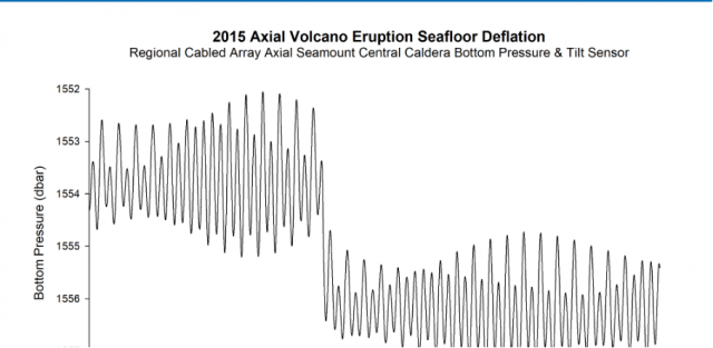
Axial Seamount Helping Scientists Forecast Eruptions
On March 20, 2023, Oregon Public Radio reported about scientists work at Axial Seamounts, a seamount and submarine volcano on the Juan de Fuca Ridge, about 480 kilometers off the coast of Oregon. The story details how bottom pressure recorders connected to OOI’s Regional Cabled Array are helping reveal the inner workings of the Axial Seamount and helping scientists forecast when it might erupt next. Featured are Oregon State University Professor Bill Chadwick, University of North Carolina Professor Scott Nooner, Oregon State University Assistant Professor Jeff Beeson, and College of Charleston Assistant Professor Haley Cabannis.
Access the article here.
Read MoreMaking the Ocean Accessible Through Sound
“Scientists are finding that people can sometimes pick up more information from their ears than the eyes can see. And ears can perceive patterns in the data that the eyes can’t see,” said Amy Bower, a Senior Scientist at Woods Hole Oceanographic Institution and Principal Investigator for the Accessible Oceans project. “Adding sound to science allows more people to experience science, follow their curiosity, and make science more accessible to all. “
Bower joined forces with a multidisciplinary team to explore ways sound could be used to visualize data. Funded by the National Science Foundation’s Advancing Informal STEM Learning Program, Bower and her team have been working for nearly two years on Accessible Oceans: Exploring Ocean Data through Sound. Their goal is to inclusively design and pilot auditory displays of real ocean data. They are implementing a process called sonification, assigning sound to data points. Each member brings expertise to the task at hand. Principal Investigator Bower is an oceanographer. Dr. Jon Bellona is a sound designer with specialization in data sonification at the University of Oregon. Dr. Jessica Roberts and graduate student Huaigu Li, both at Georgia Tech, are Learning Sciences and human-computer interaction experts. Dr. Leslie Smith, an oceanographer and specialist in ocean science education and communication at Your Ocean Consulting, Inc., rounds out the team. Bower is a blind scientist, who lends a crucial perspective in the research and overall execution of the project.
To begin, the team chose to use datasets collected by the Ocean Observatories Initiative (OOI) that had previously been transformed into classroom-ready use by Smith and the Ocean Data Labs. The team is working first on three of these curated datasets: the 2015 eruption of Axial Seamount, the vertical migration of zooplankton during an eclipse event, and carbon dioxide exchange between the ocean and the atmosphere.
“Data is made of numbers. Sonification is basically just translating numbers into sound,” Bower explained. “So instead of seeing numbers go up and down on a graph, for example, you can hear them go up and down.”
To ensure an inclusive final product, the team has undertaken a co-design process in which a variety of stakeholders have been engaged for input throughout the process. The team interviewed both subject matter experts and teachers of the blind and visually impaired to ensure that both scientific and pedagogical needs were being met. They then explored the integration of various auditory display techniques and ended up with a mix of data sonification, narration, and environmental sounds. The team put together a sample of five to six sonification examples for each data set, then surveyed a group of blind, visually impaired and sighted adults and students with science and non-science backgrounds. The survey’s purpose was to ask which sounds and which approaches might work best for both sighted and visually impaired listeners.
“We asked, for example, which of these sounds do you think best represents gases coming in and out of the ocean. The feedback was overwhelmingly in favor of a breathing sound,” said Bower. “As listeners will hear in the first example below that deals with carbon dioxide exchange between the ocean and the atmosphere, the breathing sound, with narration explaining what to expect, really brings the data to life.”
Accessible Oceans is a pilot and feasibility study for a museum exhibit that would introduce the broader public to what it’s like to experience ocean data through sound. At the end of this two-year project, the team intends to submit another proposal to design and build an exhibit that make ocean data come alive in a new and accessible way.
“As we’ve been working on this project, we’ve come to realize that to engage more people in science, technology, engineering and math, we can appeal to their ears as well as their eyes,” added Bower. “And I’m determined to help make science as accessible as possible for everyone.”
________________________________________________________________________
To hear more about Amy Bower’s work as an oceanographer and her exploration of sonification, tune into this episode of The Science of Ocean Sounds, Tumble Science Podcast for Kids.
Read More
Eighteenth Turn of the Coastal Endurance Array
On Tuesday March 7th, 11 hearty scientists and engineers from Oregon State University (OSU) are heading out to the northeast Pacific aboard the R/V Sikuliaq to recover and deploy (turn) the Coastal Endurance Array. For some of the team members, this will be the eighteenth time they have made this journey to ensure that the Coastal Endurance Array continues to report data from this important region.
The array is in an important region with coastal upwelling, where strong winds cause surface waters to be pushed offshore and water from the ocean depths is pulled up – or upwelled – to the surface to take its place. These regions comprise less than 5 percent of the ocean’s surface area, yet account for a quarter of the global fish catch. The Endurance Array has been collecting data in this region since 2016, which scientists have used to examine ocean health issues, including hypoxia, ocean acidification, and how they affect ocean life.
[media-caption path="https://oceanobservatories.org/wp-content/uploads/2023/03/IMG_6460-scaled.jpg" link="#"]The Endurance 18 will be deploying seven moorings, six gliders, and four coastal surface piercing profilers, which requires the expedition to be conducted in two legs because of space limitations on the stern. Credit: Darlene Trew Crist ©WHOI.[/media-caption]The Endurance team will be very busy during their 16-day expedition. Because of the size of the equipment, the expedition will occur in two legs so recovered equipment can be brought back to shore and replaced with equipment to be deployed. They intend to recover and deploy seven moorings and recover two gliders, while deploying a full contingent of six gliders. Three gliders will “fly” at shallow depths of 200 meters across the shelf. Another three will travel at 1000 meters depth offshore. Weather and seas permitting, the team also plans to deploy four coastal surface piercing profilers.
The team will also be conducting water sampling before and after each deployment. They will conduct CTD (conductivity, temperature, and depth) casts at the deployment/recovery sites and carry out shipboard sampling for field validation of the platforms and sensors that will remain in the water for the next six months.
Chief Scientist, Jonathan Fram, who will lead both legs of the expedition, said, “Endurance 18 is happening earlier than our usual spring expeditions, which means we are likely to face rough seas. We have a highly experienced team, the ship has an exceptional crew, and we’ll be on a weather-hardened ship, so we will be able to make the most of our time at sea. Platforms that can be deployed from a smaller vessel may be deferred to spring if there are long weather delays on this end-of-winter expedition.”
The team had already experienced some unexpected weather as a freak snowstorm covered the ocean observing equipment in the storage area in Corvallis. The team had to “clean off the cars,” so to speak, before loading the equipment onto trucks for transport to the dock in Newport, for loading on the ship.
[media-caption path="https://oceanobservatories.org/wp-content/uploads/2023/03/Screen-Shot-2023-03-06-at-10.04.08-AM.png" link="#"]A few days before ocean observing equipment in Corvallis was set to be transported to the dock in Newport for loading onto the R/V Sikuliaq, an unexpected snowstorm made its way to Corvallis, covering the equipment in white. Credit: Jon Fram, OSU.[/media-caption]In addition to OOI’s recovery and deployment operations, during leg two, University of South Carolina researcher Eric Tappa, will lead the recovery and deployment of a sediment trap adjacent to OOI’s Oregon Slope Base site. “This is an example of how OOI tries to maximize ship time by partnering with scientists and other partners and institutions to make full use of the time at sea. We are always open to discussing ways we might advance other scientific objectives,” added Fram. (See How to Participate for more information.)
[media-caption path="https://oceanobservatories.org/wp-content/uploads/2023/03/Screen-Shot-2023-03-06-at-10.06.37-AM.png" link="#"]One technical improvement that will be deployed during Endurance 18 is a new steel frame over the solar polars to prevent damage caused by frequent sea lion visitors. This is one of many incremental technical improvements that are made to OOI arrays to optimize their operations while at sea. Credit: Jon Fram, OSU.[/media-caption]During the expedition, two University-National Oceanographic Laboratory System (UNOLS) cruise volunteers will be onboard as well as two OSU undergraduates who are employed by OOI to help with the refurbishment of moorings. An OSU videographer will also be onboard to share the ongoing work. Bookmark this site and follow along on the journey.
Read More
Test Deployments Underway for Pioneer Relocation
Tuesday February 21, 2023, a team of scientists and engineers from Woods Hole Oceanographic Institution (WHOI) left Charleston, SC aboard the R/V Neil Armstrong to begin test deployments in preparation for the installation of an Ocean Observatories Initiative (OOI) ocean observing system in its new location in the southern Mid-Atlantic Bight (MAB). The science team will deploy two test moorings off the coast of North Carolina, occupying shallow and deep sites of the proposed array. The deployments will supplement computer modeling to ensure the mooring designs perform as expected in the MAB environment. Once the array is fully operational in 2024, the ocean data collected will be available online in near real-time to anyone with an Internet connection.
Ocean observing data helps to track, predict, manage, and adapt to changes in the marine environment. Coastal communities use ocean observing data to prepare for floods and other natural disasters. The instrumented arrays gather physical, chemical, geological, and biological data from the air-sea interface to the seafloor, providing a wealth of information for research and education.
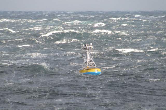
[media-caption path="https://oceanobservatories.org/wp-content/uploads/2023/02/CNSM_buoy_atsea-2-1.png" link="#"]Offshore conditions can be brutal for moorings that remain in the water for six-month deployments. The new location for the OOI’s Coastal Pioneer Array is designed to withstand treacherous conditions, including extreme storms. Credit: ©Woods Hole Oceanographic Institution.[/media-caption]“This new Pioneer Array location in the MAB offers many opportunities for scientists to obtain data to further their research, and will provide better insight into conditions in the area for a variety of stakeholders,“ said Al Plueddemann, Project Scientist for OOI’s Coastal and Global Scale Nodes group at WHOI, which is responsible for operation of the Pioneer Array. “We welcome researchers, educators, and industry members to reach out to us to explore ways we might work together to maximize the usefulness of the data.”
The OOI is funded by the National Science Foundation (NSF) to collect and deliver ocean data in select locations for 25 years or more. This longevity of data collection makes it possible for researchers to identify both short term processes and long-term trends in our changing ocean. The OOI’s Coastal Pioneer Array was designed to be relocatable, and its first deployment was off the coast of New England at the Continental Shelf/Slope interface, where it collected data from 2016 until it was recovered in September 2022. The new location off the coast of North Carolina was chosen by NSF based on input from the science community during a series of NSF-sponsored workshops in 2022.
Dr. Reide Corbett, Executive Director of the Eastern Carolina University’s Coastal Studies Institute (CSI), is enthusiastic about the opportunities the Pioneer Array will bring to the region. “The cross-shelf suite of instrumentation off northeastern North Carolina’s coast is in a region of complex physics and critical ecosystem dynamics that draws interest from many disciplines and creates opportunities for transformational science. This is also in a region with a growing renewable energy sector, including two active offshore wind leases, with opportunities to partner with the agencies involved. The Coastal Studies Institute is excited about the observations that will be made from these instruments, allowing us to better address climate change influences in the coastal ocean, and improve ocean/weather/storm forecasts through data sharing. Beyond just the instruments in the water, the new partnerships and collaborations created as part of this deployment will provide the ability to better engage this socio-economically diverse region, with disadvantaged groups more impacted by sea level rise and climate change compared to many coastal regions. This broad network of partnerships across the region will provide a mechanism to drive knowledge to action,” states Corbett.
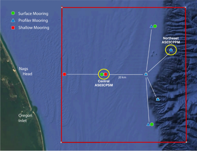
[media-caption path="https://oceanobservatories.org/wp-content/uploads/2023/02/Pioneer-MAB-schematic.png" link="#"]Schematic drawing of the Pioneer MAB moored array to be deployed off the coast of Nags Head, North Carolina. The full array, to be deployed in the spring of 2024, will consist of ten moorings at seven different sites (three sites contain mooring pairs). For the test deployment, one Coastal Surface Mooring will be deployed at the Central site and one Coastal Profiler Mooring will be deployed at the Northeast site.[/media-caption]The new MAB site represents a different environment than the New England Shelf location and offers opportunities to collect data on a variety of cross-disciplinary science topics, including cross-shelf exchange and Gulf Stream influences, land-sea interactions associated with large estuarine systems, a highly productive ecosystem with major fisheries, processes driving biogeochemical cycling and transport, and fresh-water outflows during extreme rain events.
The MAB location is expected to have different wind, wave, and current conditions than the Pioneer Array experienced on the New England Shelf. In addition, deployments in the new location will be in both shallower and deeper water depths than those off the New England coast.
A Coastal Surface Mooring (CSM) will be deployed at 30 meters depth at 35o 57.00’ N, 75o 07.5’ W. The CSM is specifically designed to examine coastal-scale phenomena and withstand the challenging conditions of shallow coastal environments. The Surface Mooring contains instruments attached to a Surface Buoy floating on the sea surface, a Near Surface Instrument Frame 7 meters below the surface, and a Seafloor Multi-Function Node (MFN) located on the seafloor. Additionally, the Surface Buoy contains wind turbines and solar panels for power generation and antennas to transmit data to shore via satellite.
A Coastal Profiler Mooring (CPM) will be deployed at 600 meters depth, 36o 03.80’ N, 74o 44.56’ W. The CPM contains a Wire-Following Profiler that houses instruments. The Wire-Following Profiler moves through the water column along the mooring riser, continuously sampling ocean characteristics from about 23 m below the surface to 23 m above the sea floor. The CPMs also carry an upward-looking Acoustic Doppler Current Profiler to measure ocean currents over the same region of the water column traversed by the profiler.
The test mooring data will be evaluated during the deployment and after recovery to determine whether any modifications are needed to the mooring designs. The plan is to deploy the full array in the spring 2024.
An update on the Pioneer Array relocation is planned for April 20 at 6 pm at the Coastal Studies Institute on East Carolina University’s Outer Banks Campus. Contributing to the CSI “Science on the Sound” lecture series, WHOI’s Dr. Plueddemann will discuss the Pioneer Array infrastructure, instrumentation, and what is planned for its upcoming move off the North Carolina coast. The event is free and open to the public. For those unable to attend, the program will be live-streamed, as well as archived for later viewing, on the CSI YouTube Channel.
[media-caption path="https://oceanobservatories.org/wp-content/uploads/2023/02/A-Frame.png" link="#"]An A-frame at the stern of the ship is used to lift an OOI Coastal Surface Mooring into the water at the start of the deployment. A team secures guidelines to ensure its movements are controlled. Credit: Darlene Trew Crist © WHOI.[/media-caption] [media-caption path="https://oceanobservatories.org/wp-content/uploads/2023/02/DSC0418-scaled.jpg" link="#"]Surface Mooring Recovery operations. Credit: Deidre Emrich © WHOI.[/media-caption]
Read More
Coastal Review Reports on Pioneer’s Relocation
The Coastal Pioneer Array will have a new home in the Southern Mid-Atlantic Bight in the spring of 2024. Just like any move, there are lots of preparations necessary. In this case, test deployments are now taking place to ensure the Array can be in tune with its new environment.
Reporter Jennifer Allen provides insight into the ongoing preparations for the move and plans forward in an article in Coastal Review.
Read More
Data Explorer Receives Environmental Business Journal Award

The Environmental Business Journal (EBJ) recognized the Ocean Observatories Initiative’s (OOI) Data Explorer’s ability to manage and visualize data with one of its annual awards for Information Technology.
Tetra Tech will accept the award at the EBJ awards ceremony in March 2023 for its role in designing open-source software to support the management, accessibility, and visualization of ocean data. Axiom Data Science, a Tetra Tech company, worked with the OOI Cyberinfrastructure team to develop both front-end and back-end systems for data management and visualization of OOI data feeds.
The OOI, funded by the National Science Foundation, delivers real-time data from sensors in the Atlantic and Pacific Oceans to address critical questions regarding the world’s oceans. Axiom Data Science played a foundational role in designing and operationalizing the Data Explorer, the primary gateway for discovering, visualizing, and accessing OOI data. The Data Explorer makes it possible to search across data points, download full datasets, and compare datasets across regions and disciplines for more than 900 instruments in near real-time. In 2022, Axiom Data Science upgraded the OOI cyberinfrastructure to improve the OOI’s ability to serve ultra-high resolution data streams from next generation ocean instrumentation that span the ocean floor to the sea surface.
“We are honored to have worked with Axiom Data Science to make OOI’s vast amount of data accessible and useable and congratulate them on this recognition of their exceptional work,” said Jeffrey Glatstein, OOI’s Data Delivery Lead and Senior Manager of Cyberinfrastructure. “The capabilities of Data Explorer are only beginning to be realized and will serve the ocean community for years to come.”
Read More
Visit to West Coast OOI Facilities
A group of Ocean Observatories Initiative (OOI) leaders visited OOI facilities at Oregon State University and the University of Washington last week to get a first-hand look at operations of the Coastal Endurance Array and Regional Cabled Array, respectively. National Science Foundation Program Director George Voulgaris, OOI Principal Investigator Jim Edson and Senior Program Manager Paul Matthias spent five days on the road meeting with their OOI west coast colleagues. The trip was designed to give recently appointed Voulgaris an opportunity to inspect the infrastructure and meet team members who keep the Coastal Endurance and Regional Cabled Arrays operational and reporting back data around the clock. Edson and Matthias seized the opportunity to meet in person with colleagues who they routinely see on the screen.
The following provides a glimpse of some of the activities that occurred during the trip:
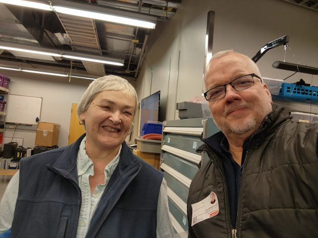
[media-caption path="https://oceanobservatories.org/wp-content/uploads/2023/02/20230207_140014.jpg" link="#"]Grant Dunn, Mechanical Engineer with the Electronic & Photonic Systems Department at UW-APL (left) describes the level-wind system on the RCA profiler mooring to Dr. George Voulgaris during a tour of the RCA laboratory facilities at the University of Washington as RCA Project Manager Brian Ittig looks on. Credit: Paul K. Matthias © WHOI.[/media-caption] [media-caption path="https://oceanobservatories.org/wp-content/uploads/2023/02/20230207_144911.jpg" link="#"]Regional Cabled Array Principal Investigator Deborah Kelley (left) and OOI Senior Program Manager Paul Matthias take a selfie to commemorate their in-person visit during a tour of the RCA facilities at the University of Washington. Credit: Paul K. Matthias © WHOI.[/media-caption] [media-caption path="https://oceanobservatories.org/wp-content/uploads/2023/02/20230207_141656.jpg" link="#"]NSF Program Director George Voulgaris (from left), OOI Principal Investigator Jim Edson look on as Regional Cabled Array technicians Grant Dunn, Mechanical Engineer with the Electronic & Photonic Systems Department at UW-APL, and RCA Chief Engineer Chuck McGuire explain the engineering associated with the RCA profiler mooring during a tour of RCA’s facilities at the University of Washington. Credit: Paul K. Matthias © WHOI.[/media-caption] [media-caption path="https://oceanobservatories.org/wp-content/uploads/2023/02/20230209_123758.jpg" link="#"]NSF Program Director George Voulgaris (left) asks OSU technician Jonathan Whitefield questions about glider operations that provide critical water column data around the moorings of the Coastal Endurance Array. Credit: Paul K. Matthias © WHOI.[/media-caption] [media-caption path="https://oceanobservatories.org/wp-content/uploads/2023/02/20230207_112718.jpg" link="#"]NSF Program Director George Voulgaris (foreground) and RCA Chief Engineer Chuck McGuire discuss the RCA data monitoring systems as OOI PI Jim Edson points to real-time data on the screen being relayed by instrumentation on the Regional Cabled Array. Credit: Paul K. Matthias © WHOI.[/media-caption] [media-caption path="https://oceanobservatories.org/wp-content/uploads/2023/02/20230209_130353.jpg" link="#"]NSF Program Director George Voulgaris (left) gets a hands-on look at the multiple instruments contained on multi-function node that will sit on the bottom of the ocean floor for six months collecting data for the Coastal Endurance Array. Coastal Endurance Array Principal Investigator Ed Dever (middle) and Project Manager Jonathan Fram the functionality of each instrument during the visit to Oregon State University. Credit: Paul K. Matthias © WHOI.[/media-caption]
Read More