
News
Communicating with Colleagues Teaching with OOI Data
The Ocean Observatories Initiative (OOI) and the OOI Ocean Data Labs are serious collaborators. While two different NSF-funded initiatives share portions of their names, their roles are different, but complementary. The OOI provides data that the OOI Ocean Data Labs Project uses to prepare instructional materials for undergraduate classrooms. It’s a collaboration that helps to expand the use of OOI data into classrooms and into the hands of potential future researchers.
To honor this collaboration, the OOI has launched a new Discourse forum “OOI in the Classroom“ where educators can share their experiences teaching with OOI data and establish dialogues with their colleagues. This forum is designed to offer an online area to share ideas, tell tales, and work to develop supportive, instructive, and challenging classroom experiences.
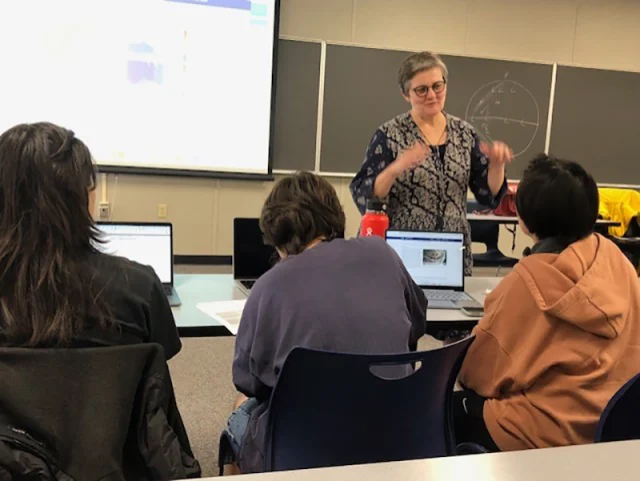
The OOI Ocean Data Labs also hosted an in-person workshop at the recent Ocean Sciences Meeting to introduce faculty to the community-developed collection of OOI Data Explorations and the online OOI Lab Manual. The workshop invited participants to integrate OOI data into undergraduate courses (Greengrove et al., 2020), to not only teach concepts in oceanography but to build transferable skills.
The Ocean Data Labs is holding a workshop (June 2-5, 2024 at the Marine Science Center, University of North Carolina Wilmington) that will focus on the relocation of the Pioneer Array to the Mid-Atlantic Bight, and the potential this move will provide for future educational lessons and student research activities. Learn more and apply to attend. Participants will be selected and notified by mid-April.
Another way to get involved is to join the Ocean Data Labs mailing list to learn of the latest innovations and lesson plans developed by this network of educators. Also, be sure to sign on to Discourse to continue the ongoing conversation within the education network of OOI data users.
Read MoreLive Data Demos at OOI Booth#210

Join OOI data expert Stace Beaulieu at the Ocean Sciences Meeting as she demonstrates how to use Data Explorer to find, compare, and share OOI data. During each session, Stace will use data from a different OOI array to demonstrate the breadth and depth of data available and how easy it is to access, download, and use. She will demo Data Explorer, followed by plenty of time to answer your questions and use this tool to explore data relevant to your research. On Wednesday morning, she’ll demo JupyterHub so you will have another tool to use OOI data in your research.
Mark your calendar, as follows, and come visit Stace at OOI’s booth #210 at the Ocean Sciences Meeting February 19-22, 2024.
Find, compare, and share OOI data
- Monday Feb 19
3:30-4:00 pm
Global Irminger Sea Array - Tuesday Feb 20
10:00-10:30 am
Coastal Endurance Array
3:30-4:00 pm
Coastal Pioneer New England Shelf Array - Wednesday Feb 21
10:00-10:30 am
JupyterHub demo for AUV data from Coastal Pioneer New England Shelf Array
3:30-4:00 pm
Global Southern Ocean Array - Thursday Feb 22
10:00-10:30 am
Regional Cabled Array
A complete list of OOI-related events at the Ocean Sciences Meeting 2024 can be found here.
Read More
OOI at Ocean Sciences Meeting 24
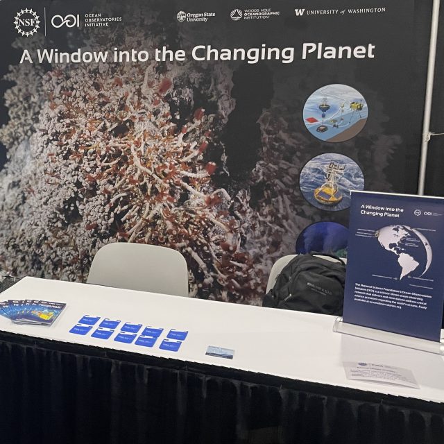
OOI will be at booth #210 at the Ocean Sciences Meeting in New Orleans from 18-23 February 2024. Please visit our booth. Daily we have an OOI data expert giving in-person demonstrations on how to use Data Explorer in your research. Times and topics will be announced soon, so stay tuned.
The following is a compilation of OOI-related presentations at this year’s Ocean Sciences Meetinh. If we’ve missed any OOI-related sessions, please contact dtrewcrist@whoi.edu and we will be happy to add them. Hope to see you in person this year! Share your OSM news at #OSM24.
Monday, 19 February 2024
09:40 – 09:50 Eastern (08:40 – 08:50 CST) 203-205, Second Floor (Convention Center)
10:03 – 10:14 Eastern (09:03 – 09:14 CST) 215-216, Second Floor (Convention Center)
10:47 – 10:58 Eastern (09:47 – 09:58 CST) 208-209, Second Floor (Convention Center)
11:45 – 11:55 Eastern (10:45 – 10:55 CST) R06-R07, Second Floor (Convention Center)
Katherine Shrader, James Madison University, Geology and Environmental Science, Harrisonburg, VA, United States, Nicole S Lovenduski, University of Colorado, Department of Atmospheric and Oceanic Sciences, Boulder, CO, United States and Genevieve Clow, University of Colorado at Boulder, Atmospheric and Oceanic Sciences, Boulder, United States
15:30-16:00 CST Exhibit Hall, Booth #210
Data Demo on Global Irminger Sea Array
15:49 – 15:58 Eastern (14:49 – 14:58 CST) 229-230, Second Floor (Convention Center)
Andrew Scherer, Oregon State University, College of Earth, Ocean, and Atmospheric Sciences, Corvallis, United States, Melanie R Fewings, Oregon State University, College of Earth, Ocean, and Atmospheric Sciences, Corvallis, OR, United States and Thomas Connolly, Moss Landing Marine Laboratories, Moss Landing, CA, United States
16:06 – 16:17 Eastern (15:06 – 15:17 CST) 225-227, Second Floor (Convention Center)
17:00 – 19:00 Eastern (16:00 – 18:00 CST) Poster Hall, First Floor (Convention Center)
15:00-18:00 CST Exhibit Hall – Visit OOI’s Booth #210
18:00 CST OOI Meet up at The Rusty Nail, 1100 Constance Street, New Orleans
Tuesday, 20 February 2024
09:30 – 11:00 Eastern (08:30 – 10:00 CST) eLightning Theater, First Floor (Convention Center)
1o:00-10:30 CST Exhibit Hall, Booth #210
Data Demo on Coastal Endurance Array
13:45 – 14:45 Eastern (12:45 – 13:45 CST) 220-222, Second Floor (Convention Center)
15:30-16:00 CST Exhibit Hall, Booth #210
Data Demo on Coastal Pioneer New England Shelf Array
15:44 – 15:55 Eastern (14:44 – 14:55 CST) 211-213, Second Floor (Convention Center)
17:00 – 19:00 Eastern (16:00 – 18:00 CST) Poster Hall, First Floor (Convention Center)
OT24B-1524 Assessment and Improvement of Dissolved Oxygen Measurements from NSF Ocean Observatories Initiative Gliders
Stuart Pearce1, Peter J Brickley2, Jonathan Whitefield3, Diana Wickman2, Collin Dobson2, Russell Desiderio3, Albert J Plueddemann2 and Edward Paul Dever4, (1)Oregon State University, College of Earth, Ocean, and Atmospheric Sciences, Corvallis, OR, United States, (2)Woods Hole Oceanographic Institution, Woods Hole, United States, (3)Oregon State University, College of Earth, Ocean, and Atmospheric Sciences, Corvallis, United States, (4)Oregon State University, Corvallis, OR, United States
OT24B-1523Application of Automated Quality Control Flags to OOI Data: Identification of Storm Events at Coastal Pioneer Array
Kylene Cooley, Woods Hole Oceanographic Institution, Ocean Observatories Initiative, Woods Hole, United States and Andrew C Reed, Woods Hole Oceanographic Institution, Woods Hole, MA, United States
OT24D-1537 Comparison of Vertical Temperature and Salinity Structures in the Northeast Pacific Ocean from Nested Regional Ocean Models
Caitlin Amos, US Naval Research Laboratory, Stennis Space Center, United States, John J Osborne, U.S. Naval Research Laboratory, Ocean Sciences Division, Stennis Space Center, MS, United States and Gregg A. Jacobs, Naval Research Lab, Stennis Space Center, MS, United States
10:00-18:00 CST Exhibit Hall – Visit OOI’s Booth #210
Wednesday, 21 February 2024
09:50-10:00 Eastern (08:50 – 09:00 CST) 210, Second Floor (Convention Center)
DO31A-03 Building Training Datasets through the Documentation of Species Diversity and Abundance at ASHES vent field, Axial Seamount, for Future Machine Learning Applications
Julia Sandke1, Danilo Seskar2, Hikari Oshiro2, Karen G Bemis3 and Dax Christian Soule4, (1)CUNY Queens College, School of Earth and Environmental Sciences, Flushing, United States, (2)Rutgers University New Brunswick, Marine and Coastal Sciences, New Brunswick, United States, (3)Rutgers, The State University of New Jersey – New Brunswick, Marine and Coastal Sciences, New Brunswick, United States, (4)CUNY Queens College, School of Earth and Environmental Sciences, Flushing, NY, United States
1o:00-10:30 CST Exhibit Hall, Booth #210
JupyterHub demo for AUV data from Coastal Pioneer New England Shelf Array
15:30-16:00 CST Exhibit Hall, Booth #210
Data Demo on Global Southern Ocean Array
17:00-19:00 Eastern (16:00 – 18:00 CST) Poster Hall, First Floor (Convention Center)
OT34B-1585 A Glider Study of Seasonal Changes in Bio-Optical Properties and Phytoplankton Biomass at the New England Shelf Break Front
Robert D Vaillancourt, Millersville University of Pennsylvania, Millersville, PA, United States and Michael A. Miller, Millersville University of Pennsylvania, Earth Sciences, Millersville, United States
ED34B-0145 Correlation of Diffuse Venting with Geophysical Time Series at Axial Seamount
Cal Mills1, Melissa Celik1, Fabio Dos Santos1, Karen G Bemis2 and Dax Christian Soule3, (1)CUNY Queens College, Flushing, United States, (2)Rutgers, The State University of New Jersey – New Brunswick, Marine and Coastal Sciences, New Brunswick, United States, (3)CUNY Queens College, School of Earth and Environmental Sciences, Flushing, NY, United States
PS34B-2105 What makes the seasonal stratification breakdown at the US Northeast shelfbreak front so rapid? – Comparing contributions from surface forcing, local mixing, and lateral advection
Lukas Lobert1,2, Ke Chen2, Albert J Plueddemann2 and Glen Gawarkiewicz2, (1)Massachusetts Institute of Technology, Cambridge, United States, (2)Woods Hole Oceanographic Institution, Woods Hole, United States
10:00-18:00 CST Exhibit Hall – Visit OOI’s Booth #210
Thursday, 22 February 2024
10:14-10:25 Eastern (09:14- 09:25 CST) 225-227, Second Floor (Convention Center)
PI41A-05 Interannual variability in the physical and biological drivers of carbon sequestration in the southeast Pacific Subantarctic Mode Water Formation region
Peter Brown1, Pablo Trucco-Pignata2, Maribel García-Ibáñez3, Dorothee C E Bakker4, Sophy Oliver1, Paula C. Pardo5 and Adrian Martin1, (1)National Oceanography Centre, Southampton, United Kingdom, (2)University of Southampton, Southampton, United Kingdom, (3)Institut de Ciències del Mar – CSIC, Barcelona, Spain, (4)University of East Anglia, Centre for Ocean and Atmospheric Sciences, School of Environmental Sciences, Norwich, United Kingdom, (5)Instituto de Investigacións Mariñas (IIM-CSIC), Vigo, Spain Peter Brown1, Pablo Trucco-Pignata2, Maribel García-Ibáñez3, Dorothee C E Bakker4, Sophy Oliver1, Paula C. Pardo5 and Adrian Martin1, (1)National Oceanography Centre, Southampton, United Kingdom, (2)University of Southampton, Southampton, United Kingdom, (3)Institut de Ciències del Mar – CSIC, Barcelona, Spain, (4)University of East Anglia, Centre for Ocean and Atmospheric Sciences, School of Environmental Sciences, Norwich, United Kingdom, (5)Instituto de Investigacións Mariñas (IIM-CSIC), Vigo, Spain
1o:00-10:30 CST Exhibit Hall, Booth #210
Data Demo on Regional Cabled Array
12:10-12:200 Eastern (11:10- 11:20 CST) 217-219, Second Floor (Convention Center)
OT42A-05 Adding a wave energy converter to the Pioneer Array Coastal Surface Mooring
Ryan Coe, PhD1, Albert J Plueddemann2, Giorgio Bacelli3, Derek Buffitt4, J. Andrew Hamilton5, Kevin Dullea6, Scott Jenne7, Frederick Driscoll8, Umesh A Korde9, Salman Husain8, Mike Muglia10, Jantzen Lee6, Johannes Spinneken11, Sahand Sabet8, Carrie Schmaus12, John Reine13, Patterson Taylor14, Donald Peters13, Amanda M Vieillard15 and Eric Wade16, (1)Sandia National Laboratories, Water Power Technologies, Albuquerque, United States, (2)Woods Hole Oceanographic Institution, Woods Hole, United States, (3)Sandia National Laboratories, Albuquerque, United States, (4)Woods Hole Oceanographic Institution, Applied Ocean Physics and Engineering, Woods Hole, United States, (5)Monterey Bay Aquarium Research Institute, Moss Landing, CA, United States, (6)Sandia National Laboratories, United States, (7)National Renewable Energy Laboratory Golden, Golden, United States, (8)National Renewable Energy Laboratory, United States, (9)Johns Hopkins University, Baltimore, MD, United States, (10)Coastal Studies Institute, United States, (11)Evergreen Innovations, United States, (12)Department of Energy, Water Power Technologies Office, Washington DC, United States, (13)Woods Hole Oceanographic Institution, United States, (14)University of North Carolina Coastal Studies Insitute, Wanchese, NC, United States, (15)US Department of Energy, Water Power Technologies Office, Washington, DC, United States, (16)East Carolina University, Greenville, United States
17:00-19:00 Eastern (16:00 – 18:00 CST) Poster Hall, First Floor (Convention Center)
OT44A-1627Towards acoustic observations of ocean basin temperatures using the Kauai beacon and Ocean Observatories Initiative Hydrophones
John Ragland1, Nicholas Durofchalk2, Shima Abadi1, David Dall’Osto3 and Kay Gemba2, (1)University of Washington, Seattle, United States, (2)Naval Postgraduate School, Monterey, United States, (3)Applied Physics Laboratory University of Washington, Seattle, United States
ED44C-0222An Introductory Oceanography lab sequence implementing a combination of OOI Data Labs and basic lab science experiments
Alexander Wurm, Western New England University
OB44F-1014 Fall-Winter Seasonal Dynamics in the In Situ Bio-Optics for the Mid-Atlantic Bight
Teemer Barry, Rutgers University New Brunswick, Marine & Coastal Sciences, New Brunswick, United States, Oscar Schofield, Rutgers University, Center of Ocean Observing Leadership, School of Environmental and Biological Sciences, New Brunswick, United States and Grace Saba, Rutgers University, Department of Marine and Coastal Sciences, New Brunswick, United States
ED44C-0218 The OOI Data Lab Manual: Using large ocean observatory data to improve data literacy in multi-modal undergraduate courses
Anna Pfeiffer-Herbert, Stockton University, Galloway, United States, Denise Bristol, Hillsborough Community College – SouthShore, Biological and GeoSciences, Ruskin, United States, Charles Sage Lichtenwalner, Rutgers University, Marine and Coastal Sciences, New Brunswick, United States and Janice McDonnell, Rutgers University New Brunswick, Marine & Coastal Sciences, New Brunswick, United States
ED44C-0220 Engaging Introductory Oceanography Students with Real Data in the Classroom and Online: OOI Data Exploration and Data Labs
Melissa Hicks, PHD, Onondaga Community College, Liberal Arts and Sciences, Syracuse, NY, United States
ED44C-0220 Engaging Introductory Oceanography Students with Real Data in the Classroom and Online: OOI Data Exploration and Data Labs
Mikelle Nuwer, University of Washington, School of Oceanography, Seattle, WA, United States
ED44C-0219 A Scaffolded Approach to Data Literacy Skills in 2YC Students using Authentic Data from OOI and other Sources
Denise Bristol, Hillsborough Community College – SouthShore, Biological and GeoSciences, Ruskin, United States, Anna Pfeiffer-Herbert, Stockton University, Galloway, United States and Jessica Olney, Hillsborough Community College, Physical Sciences, Tampa, United States
10:00-13:00 CST Exhibit Hall – Visit OOI’s Booth #210
Friday, 23 February 2024
09:34 -09:43 Eastern (08:34- 08:43 CST) 208-209, Second Floor (Convention Center)
ED51A-01 Reflections from the OOI Data Labs Community of Practice
Janice D McDonnell, Rutgers University New Brunswick, Department of Youth Development, New Brunswick, United States, Charles Sage Lichtenwalner, Rutgers University, Marine and Coastal Sciences, New Brunswick, United States, Ellen A R Iverson, Carleton College, SERC, Northfield, MN, United States, Ellen Altermatt, University of Utah, Utah Education Policy Center, Salt Lake City, United States, Anna Pfeiffer-Herbert, Stockton University, Pomona, United States, Denise Bristol, Hillsborough Community College – SouthShore, Biological and GeoSciences, Ruskin, United States and Dax Christian Soule, CUNY Queens College, School of Earth and Environmental Sciences, Flushing, NY, United States
09:43 -09:52 Eastern (08:43- 08:52 CST) 208-209, Second Floor (Convention Center)
ED51A-02 Using interactive OOI data visualizations to improve data literacy and scientific reasoning skills in undergraduate students
Gabriela W Smalley1, Charles Sage Lichtenwalner2, Andrea Drewes1 and Kathy Browne1, (1)Rider University, United States, (2)Rutgers University, Marine and Coastal Sciences, New Brunswick, United States
09:52 – 10:01 Eastern (08:52- 09:01 CST) 208-209, Second Floor (Convention Center)
ED51A-03 Research Shows OOI Data Lab Activities Enhance Student Success
Claire Condie, Middlesex County College, Edison, United States
10:01-10:10 Eastern (09:01-– 09:10 CST) 208-209, Second Floor (Convention Center)
ED51A-04 Using Oceanographic Mooring and Satellite Datasets to Teach Data Analysis and Scientific Computing Skills for Undergraduate Students
Hilary I Palevsky, Boston College, Earth and Environmental Sciences, Chestnut Hill, United States
15:02-15:12 Eastern (14:02-14:12 CST) 211-213, Second Floor (Convention Center)
RH53A-01 From shelfbreak to shoreline: What is the relationship between coastal sea level and local ocean dynamics?
Carolina Camargo1, Christopher G Piecuch1 and Britt Raubenheimer2, (1)Woods Hole Oceanographic Institution, Woods Hole, United States, (2)Woods Hole Oceanographic Institution, Applied Ocean Physics & Engineering, Woods Hole, United States
Battling the Corrosive Properties of Seawater
OOI engineers face the challenge of keeping ocean observing equipment operational in demanding locations for up to a year at a time. In addition to wind, waves, extreme pressure, ship traffic and trawling disruption, engineers continually battle the corrosive properties of salt water.
Senior Technician for OOI’s Coastal Endurance Array Kristin Politano provided a primer on OOI’s tactics to prevent corrosion of its equipment and instrumentation. “It’s a fun balancing act between cost versus strength versus weight versus durability. Different metals are great for certain things, so we use them in different places.”
OOI engineers try to avoid all forms of corrosion, especially galvanic corrosion, an electrochemical process where one metal corrodes preferentially in the presence of an electrolyte. In this case, seawater serves as the electrolyte or the corrosion “enabler.” When two dissimilar metals are connected in seawater, one of them is going to corrode faster than the other.
Since zinc is very prone to corrosion and corrodes much faster than other materials used on OOI moorings, engineers use it as a “sacrificial lamb” in OOI operations. They place zinc strategically on the moorings to encourage galvanic corrosion to occur on the zinc, rather than degrading instruments, electronics, and the frames that hold the moorings and instrumentation in place.
Politano gave an example of how zinc works to protect other metals used on the moorings. Aluminum is used on the Coastal Surface Piercing Profiler frames (CSPP), the Near-Surface Instrument Frames (NSIF), a cage that contains ocean observing instruments below surface moorings, and Multi-function Nodes (MFN) frames, which are at the base of some surface moorings and act both as anchors as well as platforms to affix instruments.
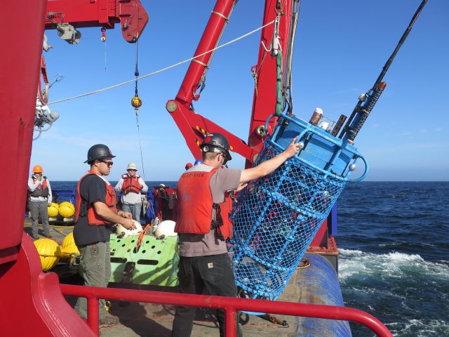
[media-caption path="https://oceanobservatories.org/wp-content/uploads/2024/01/IMG_376765-scaled.jpg" link="#"]Members of the Coastal Endurance Team deploy a Coastal Surface Piercing Profiler (CSPP) into the Pacific off the coast of Oregon. The zincs are the bare metal disks attached to the CSPP frame near loops at the top of the frame. Credit: Jon Fram, OSU.[/media-caption]The NSIF, MFN, and CSPP have sacrificial zinc cylinders attached so that when the frames containing the instruments go into the water, the aluminum doesn’t degrade as quickly as it might otherwise. The zinc will degrade first, providing a protective layer for the important assets within the frames. “Zinc serves as a really effective form of galvanic corrosion protection,” Politano added. “Zincs come in many different form factors, but we use ones that can be bolted directly to the mooring frames and other mechanical components,” said Politano.
Location Dictates Effectiveness
Zincs are used on both the Coastal Endurance’s inshore and offshore mooring platforms. The zincs on the inshore platforms dissolve faster and require replacement more often due to low dissolved oxygen conditions and that encourage corrosion. Zincs on the offshore moorings last longer due to a higher oxygenated environment offshore.
Decisions about materials to use on various parts of the moorings also in part, depends on durability, conditions, and cost. Stainless steel is very durable and reacts to form a protective oxide film on its outer surface, but this reaction needs oxygen to grow and repair itself. In areas with hypoxia (lack of oxygen) particularly in the summer months, there is not enough oxygen in the water column for the stainless oxide layer to rebuild and repair itself.
[media-caption path="https://oceanobservatories.org/wp-content/uploads/2024/01/MFN.jpg" link="#"]Coastal Pioneer Array Team members get ready to deploy a 9000-pound multi-function node off the coast of Martha’s Vineyard. Credit: Rebecca Travis © WHOI.[/media-caption]Delrin, a high-grade plastic (acetyl resin), is also used on the moorings as a corrosion preventive measure. Because of Delrin’s durability, stiffness, light weight, and water resistance, Delrin is used in instrument housings and electrical panels because it doesn’t conduct electricity, but it lacks the strength of aluminum. “Delrin is strong, but not as strong as aluminum. So, we wouldn’t make a mooring tower or a mooring Halo out of a plastic material,” said Politano. Components above water are made from aluminum because it is lightweight and extremely strong. To increase strength and resilience, above water aluminum components are powder coated that prevents water from contacting the metal. The powder coating contains various pigments, polymer resins, curatives, leveling agents, and other additives, which is applied to an aluminum surface with an electrostatic spray. “The powder coating is sprayed on, and cured in an oven that triggers a chemical reaction that hardens the coating, making a hard shell, protecting the metal beneath it,” she explained. “A good way to imagine it is like a big M&M covering the chocolate metal inside,” she added.
The OOI team uses silicon bronze (bronze coated with a silica coating) and titanium for many underwater components. The silicon bronze has mild anti-fouling properties, which is important for OOI’s coastal arrays to help reduce biofouling. The mooring components go from a bright coppery color to a green, blue patina color. The patina acts as a durable, strong, protective layer that is highly resistant to corrosion and doesn’t fatigue. “We use silicon bronze to bolt instrument clamps to MFN and NSIF frames and to attach instrument to the frames. The benefit of silicon bronze is that it is much cheaper than some of the other materials like titanium, so we can afford to use it many places,” said Politano.
Balancing Cost and Placement Considerations
Titanium is a fantastic material to use in the marine environment because it is highly corrosion resistance, very strong, and can remain in a marine environment for a long time. The downside is that it is very expensive, so it is used judiciously. Titanium also has a high strength to weight ratio, which makes it ideal for floating things in the water column and it is used to bolt together all of the critical structural mooring components. For instance, titanium bolts are used to connect surface buoys to the electromechanical chain (EM), which contains electrical components allowing power and communication with the below surface elements, to the NSIF and stretch hoses to the MFN, which anchors the mooring on the sea floor. Like stainless steel, titanium has a protective oxide layer with the ability to “heal itself.”
In addition to strength, durability, and cost the OOI team must consider the mix of materials it uses, avoiding places where two metals might touch each other. For example, copper is used as a primary anti-fouling material to mitigate the ever-present challenge of minimizing marine growth. Copper is soft so it isn’t used to attach critical mooring components. Care must be taken to avoid any dissimilar metals coming in contact with one another. The outcome of such contact would be an extreme case of galvanic corrosion!
“It really is this sort of ballet of trying to balance the cost of the material versus the strength of the material versus the weight. We put lightweight materials above the water. The expensive materials that are really strong are used to hold the whole mooring together. And then the in-between materials that are strong, but not as expensive as the really strong materials, are used to hold all the instruments together. So, it’s a fun little balancing act,” Politano concluded.
As it turns out choosing the right materials also is a good return on investment. According to OOI Lead Systems Engineer Matthew Palanza, “While the cost of these corrosion-prevention materials is high, the loss of equipment and data due to failures caused by corrosion is much greater. Incorporating corrosion-prevention materials into the array extends their service life much longer. This makes it possible for some housings, connectors, and other components to be re-used every time an array is redeployed. In fact, some housings are designed to last for the 30-year duration of the program.”
Read MoreNew Coastal Endurance Array Video
Learn about Coastal Endurance Array operations through the lens of Oregon State University videographer Kim Kenny.
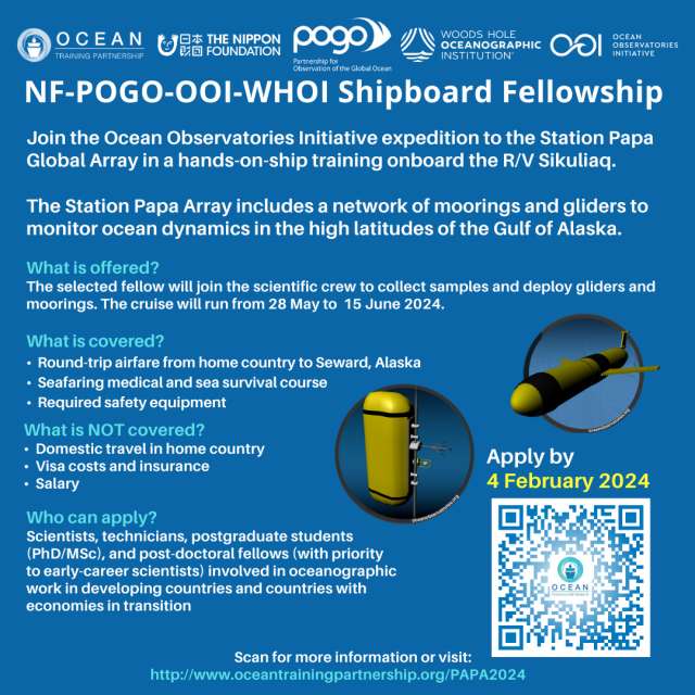
[embed]https://youtu.be/5_Yb7kN0BcI?si=AYrVivjUbXwOhF5r[/embed] Read MoreShipboard Training Fellowship Announced
|
|
Live Stream with Former OOI Engineer
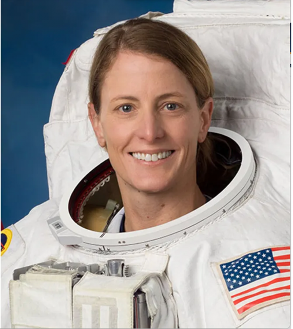
Jan 23, 2024 03:00 PM
Register here.
Tuesday January 23 brings the opportunity to join a live downlink from the International Space Station (ISS) featuring NASA astronaut and former WHOI and OOI engineer, Loral O’Hara. Loral will share insights, answer questions, and discuss the many fascinating connections between exploration in space and the ocean. Also on stage will be Alvin Program Manager Bruce Strickrott and WHOI marine microbiologist Julie Huber.
Read MoreCGSN Events at OSM24
The Coastal and Global Scale Nodes (CGSN) group of the Ocean Observatories Initiative (OOI) is excited to be sharing recent technical and data advances with the Ocean Science community at the 2024 Ocean Sciences Meeting in New Orleans, LA. With a talk and poster, CGSN is demonstrating how we are advancing our ocean observing capabilities by (1) repurposing engineering data to expand wave observations, and (2) utilizing automated data quality control algorithms in an efficient way to identify storm events. These presentations exhibit how we are advancing our mission of being a science-driven ocean observing network that delivers real-time data from more than 900 instruments to address critical science questions regarding the world’s oceans.
The first opportunity to see CGSN in action at OSM24 is the talkExpanding surface wave observations at the OOI Pioneer Array – New England Shelf using buoy motion sensors at 9:00 am on Monday, Feb. 19th, as part of the session “OT11A: Innovation in in Situ Sensors and Sensing Platforms to Measure the Ocean I”. The Pioneer Array – New England Shelf collected data across the New England Shelf break for nine years from November 2013 through November 2022. Of the three surface moorings deployed across the array, only the Central Surface Mooring was equipped with a wave sensor. Recognizing that data from a single location could be restrictive for some types of analysis, CGSN identified an opportunity to increase the number of surface wave observations and extend their geographic extent to the full cross-shelf span of the Pioneer Array – New England Shelf. This was accomplished by using the engineering data (acceleration, angular rate, and magnetic vectors) collected by the MicroStrain 3-axis motion sensors (MOPAK) deployed on all three surface moorings. The data collected by the MOPAKs can be used to compute the bulk and directional wave statistics at each Surface Mooring in the array.
The next opportunity to learn about advances in CGSN data quality is at the posterApplication of Automated Quality Control Flags to OOI Data: Identification of Storm Events at Coastal Pioneer Array from 4 – 6 pm on Tuesday, Feb. 20th as part of the session “OT24B: Enhancing Data Quality Control in Ocean Sciences: Challenges and Innovations”. Quality control flags for the meteorological bulk flux package of instruments (METBK) from the recently-implemented quality tests based on the Integrated Ocean Observing System (IOOS) Quality Assurance / Quality Control of Real Time Oceanographic Data (QARTOD) standards may help data users identify and filter for events of interest that are hidden in OOI’s long-term records. The ability to flag interesting events is made more robust by the OOI Data Team’s efforts to complete data deep dives and add human-in-the-loop (HITL) annotations before the quality test thresholds are calculated. As a result of this process, the thresholds for barometric pressure recorded at the Pioneer Array – New England Shelf surface moorings are well-suited to identify storm events as unusually low pressure systems pass over the array.
These are two examples of ways that OOI is advancing the field of ocean observing and delivering science-ready data to the Ocean Sciences community.
Read MoreAUV Data Available in a Variety of Formats
We recently announced and demonstrated new access to autonomous underwater vehicle (AUV) data through OOI’s Data Explorer. Since the initial announcement, more has been done to provide additional AUV data and improve data delivery. As part of OOI’s efforts towards Findable, Accessible, Interoperable, and Reusable (FAIR) data, not only are AUV data easier to find and access, we now are providing these data in more interoperable and reusable formats.
When you view an AUV Deployment in Data Explorer (FIG 1), data in different formats may be accessed either through the Metadata link in the left panel (FIG 1 A) or the Downloads button (FIG 1 B). The Downloads button provides access to data products, in formats including comma separated variable (CSV), that are derived from Network Common Data Form (NetCDF) files in the OOI Raw Data Repository. To access these NetCDF files, open the Metadata link, navigate into that deployment’s folder, and then into its PROFILES subfolder. Note that each deployment’s folder also contains raw data as collected by the vehicle and an EXPORTED subfolder for data products in Matlab format.
[media-caption path="https://oceanobservatories.org/wp-content/uploads/2024/01/AUV_OOI_newsletter_Fig1_portrait.png" link="#"]Fig. 1 AUV Deployment in Data Explorer. Inset A: Metadata link to Raw Data Repository to access NetCDF format per deployment in PROFILES subfolder. Inset B: Downloads button provides data products in multiple formats. Credits: Screen grab from Data Explorer (https://dataexplorer.oceanobservatories.org/#platform/c646022c-ce04-5be8-8cd8-117da55121fa/v2?pid=14&tab=visualization) and Flaticon. Flaticon license: Free for personal and commercial use with attribution.[/media-caption]The software development effort by OOI’s Coastal & Global Scale Nodes (CGSN) Team to publish AUV data into Data Explorer involved OOI’s Cyberinfrastructure Team and Axiom Data Science. This effort builds on earlier work by OOI’s Coastal Endurance Array Team to publish glider data into the IOOS Glider DAC, and subsequently into OOI’s Data Explorer. The existing code base was integrated into a larger framework supporting the input of either glider or AUV data and supporting output formatting compatible with either or both the Glider DAC or Data Explorer.
CGSN maintains two AUV platforms, which are deployed from shipboard as part of at-sea operations in and around OOI mooring sites. The AUVs conduct ~24 hour transects, consisting of multiple profiles of the water column, before being retrieved by the ship for data collection and maintenance. CGSN AUV platforms are fitted out with a variety of instrumentation including CTD, fluorometer, and sensors for photosynthetically active radiation, dissolved oxygen, dissolved nitrate, and current measurement. When applicable, annotations are provided per deployment per instrument in OOI’s OOINet portal and M2M (Machine to Machine) interface; we plan to incorporate these annotations into NetCDF metadata and ultimately into Data Explorer.
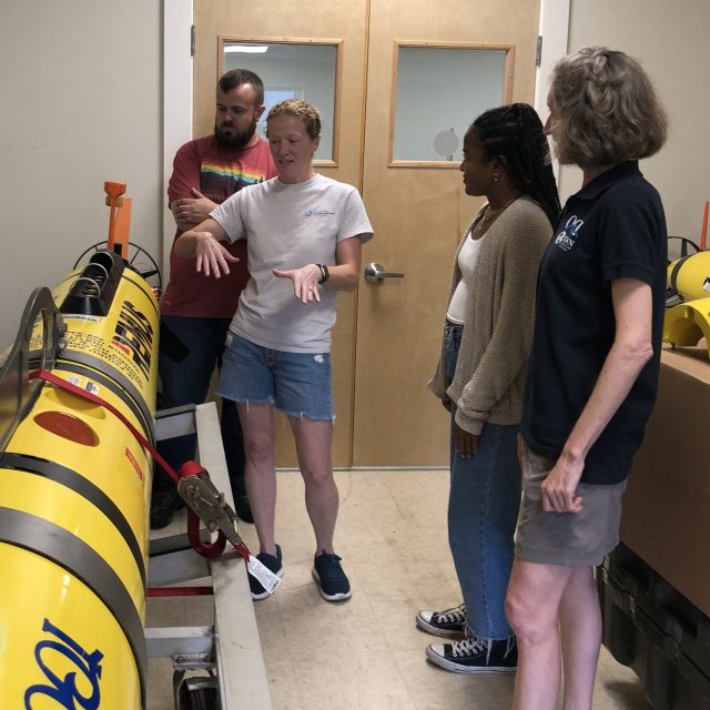
[media-caption path="https://oceanobservatories.org/wp-content/uploads/2024/01/IMG_126519-2.jpg" link="#"]CGSN Team member Diana Wickman (2nd from left) explains how the AUV moves during a deployment, with CGSN Team members Collin Dobson (far left) and Stace Beaulieu (far right) and student researcher Taina Sanchez (2nd from right). Credit: D. Trew Crist © WHOI.[/media-caption]
The Data Explorer provides access to all across-shelf and along-shelf AUV deployments at the Coastal Pioneer NES Array from 2016 to 2022.Future AUV transect data at the Coastal Pioneer MAB Array will also be published through Data Explorer as the data become available. As an example for reusability of these data in newly-available formats, a student examined across-shelf patterns in salinity, chlorophyll, and nitrate as part of Northeast U.S. Shelf Long-Term Ecological Research.
Read More
Using Sound to Create Accessible Ocean Data

Mindy Todd of WCAI Radio interviewed Amy Bower, Woods Hole Oceanographic Institution physical oceanographer and senior scientist, and Jon Bellona, sound artist with Harmonic Laboratory and senior instructor of audio production at the University of Oregon about their “Accessible Ocean” project, which uses sound to portray OOI data. The team is applying a “sonification” process that maps numbers into sound to OOI data nuggets, created by the Ocean Data Labs for use in the classroom. Their goal is to inclusively design and pilot auditory displays of real ocean data that can ultimately be included in museum displays to reach broad audiences.
Listen in here.
Learn more about the Accessible Ocean project here.
[caption id="attachment_33007" align="aligncenter" width="1760"]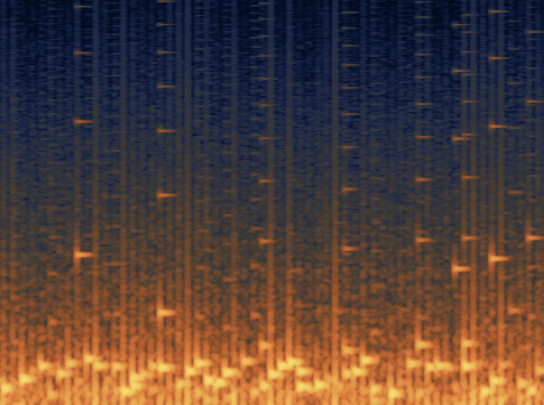 Data sonification. ©WHOI.[/caption]
Read More
Data sonification. ©WHOI.[/caption]
Read More