
News
Sophie Clayton: Curious, Creative, with an Irrepressible Desire to Understand Connections
 Sophie Clayton, Assistant Professor, Old Dominion University[/caption]
Sophie Clayton learned how to swim before she could walk. She spent her early years with her family exploring beaches during summer vacations in the south of France. Her fascination with being in and around the water never waned. Her dad finally relented and bought Sophie her first pair of diving fins when she was seven, even though he thought her curiosity might sweep her away!
Early on, Sophie excelled in math and science, but a move to Scotland at age 16 started her on a new track. Her first stint at higher education landed her in art school, where she majored in fine art, photography her primary medium. After graduating, uncertain of her next steps, she took a gap year in Australia. There, too, the water called her name.
A SCUBA diving course north of Sydney, put her on track to become a divemaster and then a diving instructor. She went on to teach diving on the Great Barrier Reef and in the Maldives, spending seven days a week in the water for the better part of three years.
One day it dawned on Sophie that she needed to better understand the environment in which she had surrounded herself. She decided to become an oceanographer. She headed back to the UK, north west Wales in fact, offering quite a different environment than the tropics, where she earned a degree in oceanography.
From there, the path was rapid and clear—mostly. In 2006 she landed a Research Experience for Undergraduates (REU) spot at Woods Hole Oceanographic Institution (WHOI) advised by physical oceanographer Prof. Annelisa Bracco. She was admitted to the WHOI/MIT Joint Program in oceanography the following year and earned her PhD in Physical Oceanography. After a postdoctoral stint at the University of Washington, Sophie returned to the East coast to join the Ocean and Earth Sciences faculty at Old Dominion University as an Assistant Professor
Always an artist
“I seem to have come full circle from my art school days. Now I’m working with imaging instruments, studying phytoplankton. I get a lot of people asking me: aren’t art and science really different and don’t you feel like art school was a waste? My answer is always ‘Absolutely not!’ I use a lot of my in art school training—independent study and researching around a topic—we were taught to explore ideas and approach them from every angle. I apply the same thought processes to my science now. The difference is the toolkit.”
Sophie excels in making connections, which are not always obvious. While trained in physical oceanography, she studies the interactions between the ocean biology, biogeochemistry, and physics. As a result, she pulls lots of the pieces together in a system to see how they all work in concert. The question she is now exploring is how ocean circulation features, especially fronts and eddies, shape phytoplankton communities. She strives to answer this question by looking at the big picture: the impact of how much light they get, the supply of nutrients, what happens when mixing communities from different places together.
Mentors and Networking
When asked about who helped mentor her along the way, Sophie responded that “lots of people have.” She called out Prof. David Bowers, a physical oceanographer who advised her during her undergraduate studies in the UK, Prof. Annelisa Bracco, her WHOI REU mentor, and Prof. Mick Follows, her graduate advisor at MIT, for their support and guidance at important transitions in her life, but said that many others have helped her on her circuitous path.
“As a grad student, I made a point of going to talk to people about their research and to discuss my work and ideas. I have been really lucky to have built relationships that have come about from these conversations and keeping in touch over the years.” She views her mentors as a combination of senior people, both men and women, who have helped her in her career, and her peers, who have provided practical advice on advancing her science, teaching, and life. “Senior women in particular have shown me what’s possible and served as examples of how it is done.”
When asked for counsel for other women considering careers in science, Sophie suggests taking the time to find the right graduate and post doc advisors. “These folks have a tremendous impact on our lives and our future, so it’s important to take the time to make sure that they are a good fit and you will work well together.” Her other words of advice are “talk to people, chatting about your science is important and you’ll be surprised at not only what you learn but the connections you will make.”
Profiles of Other Exceptional OOI Women
[caption id="attachment_20424" align="alignnone" width="300"] Hilde Oliver, Postdoctoral Scholar, Woods Hole Oceanographic Institution[/caption]
[caption id="attachment_20423" align="alignnone" width="300"]
Hilde Oliver, Postdoctoral Scholar, Woods Hole Oceanographic Institution[/caption]
[caption id="attachment_20423" align="alignnone" width="300"] Hilary Palevsky, Assistant Professor, Boston College[/caption]
Read More
Hilde Oliver: Carrying on the tradition of smart, educated women
HIlde Oliver, Postdoctoral Scholar, Woods Hole Oceanographic Institution[/caption]
Hilde Oliver, an oceanographer studying biophysical interactions and a Woods Hole Oceanographic Institution (WHOI) Postdoctoral Scholar, comes from a long line of educated women. Both her grandmother and her mother have PhDs in science, so Hilde is a third-generation woman in science.
“I come from an environment where women were strongly encouraged to pursue science. Not only did my grandmother and mother serve as role models growing up, but they were also always fully supportive of me doing this type of work,” said Hilde.
Midway through her pursuit of her PhD in marine sciences, Hilde was surprised to learn that her grandmother had initially been interested in studying oceanography herself but ended up studying biology. “It was a time when women weren’t encouraged to do that type of work and weren’t really wanted in ship environments. It was interesting to learn that we had similar interests.”
Hilde also attributes her predilection toward the sciences due to living in the small city of Oak Ridge, TN, home of Oak Ridge National Laboratory and a community oriented toward math and science. Growing up there instilled in her a “love for all things math and science.” Her interests ran the gamut from biology, chemistry, physics, and math.
During her freshman year, settling in as a math major at the University of South Carolina, Hilde took an Honors Ecology and Evolution class. During this class, she learned how to apply simple differential equations to fundamental predator-prey interactions—knowledge that launched her trajectory as an ocean ecosystem modeler. Hilde went on to earn her PhD from the University of Georgia and headed north to Woods Hole Oceanographic Institution for a postdoc position with Dennis McGillicuddy and Gordon Zhang.
Studying plankton with models and observations
At WHOI, Hilde is investigating how changing large-scale circulation influences phytoplankton growth in the Mid-Atlantic Bight. She is adding observational work to her modeling efforts using OOI glider data. “I thoroughly enjoy working at WHOI, where OOI is managed and operated. It is so exciting to be working in the environment where people are developing and deploying the instrumentation I’m applying in my research.” OOIs physical and biogeochemical datasets have allowed her to study biophysical interactions near the New England shelfbreak as a part of the larger NSF-funded Shelfbreak Productivity Interdisciplinary Research Operation at the Pioneer Array (SPIROPA) project.
Hilde also recently spent 60 days aboard the global-class research vessel R/V Roger Revelle with a team operating a towed underwater microscope system, the Video Plankton Recorder. The scientific team headed to the Pacific sector of the Southern Ocean to assess the chemical and biological conditioning of Subantarctic Mode Water, which is formed north of the Antarctic Circumpolar Current. The team was in search of coccolithophores, phytoplankton that form calcium carbonate shells.
Due to covid restrictions, the team was forced to depart from Honolulu, traveling all the way from 21° North to 60° South. The length of the transit to the research site nearly doubled their time at sea. This long transit left the team with only 32 days to conduct their research, which they used to full advantage, including finding coccolithophores.
A solid foundation of support
Many have played pivotal roles in Hilde’s path to the sciences. In addition to her family legacy, Hilde’s PhD advisor, Patricia Yager, was hugely instrumental in encouraging Hilde as a woman in science. Yager taught her the ins and outs of being a female scientist in a field once dominated by men while encouraging Hilde to pursue her own ideas.
“Tish (Patricia) instilled in me the confidence to become independent in my thinking,” she explained. “And, for any early-career person developing that independence is critical. So I am very grateful to her for that.”
Hilde offers that two takeaways from her positive relationship with Yager: “It’s important to work with people you want to work with, particularly during your PhD, for you are signing on for five or more years, a long time if it’s not a good fit. Also, it’s vital to develop a working relationship based on mutual respect so that everyone can positively benefit from the time spent together.”
With these tenets in mind, Hilde hopes to one day build a research program of her own that is highly interdisciplinary, takes advantage of the variety of datasets and tools available, and serves to help early-career scientists advance their own research ideas to their fullest expression.
Profiles of Other Exceptional OOI Women
[caption id="attachment_20423" align="alignnone" width="300"] Hilary Palevsky, Assistant Professor, Boston College[/caption]
[caption id="attachment_20422" align="alignnone" width="300"] Sophie Clayton, Assistant Professor, Old Dominion University[/caption]
Read More Shade and Poop at Sea: Increasing Solar Panel Efficiency
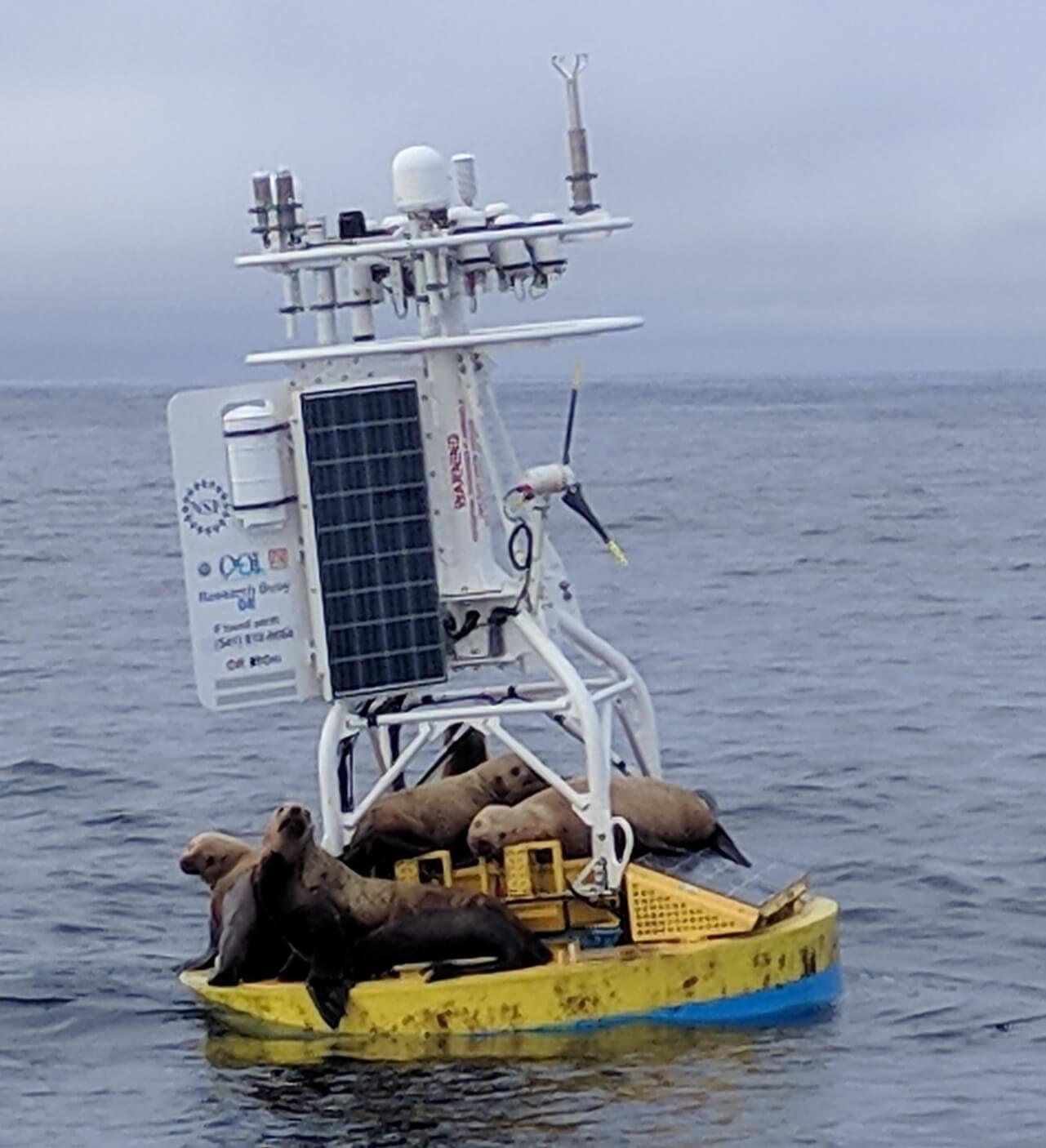
Sea lions intermittently visit the Coastal Endurance Array moorings off the coast of Oregon, where they lounge, bask in the sun, and “do their business.” These visits create two problems for the optimum functioning of the instrumented arrays. Because sea lions are heavy, some weighing up to 2,500 pounds, the solar panels upon which they rest need to be strong enough to bear this weight. And, excrement left behind by these itinerant visitors smears and shades the solar panels, making less power available for the ocean observing instrument attached to the arrays.
This intermittent excrement-related shading compounds an existing shading problem caused by the perpetual movement of the moorings. The halos at the top of the moorings cast shadows over the panels below, resulting in a significant power loss. If ten percent of a solar panel is covered in shadow, for example, its output can drop by as much as 70 percent. When sea lions take refuge on the solar panels this loss is exacerbated. Their excrement, at times, can cover up to 30 percent of the panels, virtually wiping out the power generating capability of the panels. Luckily, this coverage results in only a temporary power shortage as wind and seawater ultimately wash away the remains of these visits.
OOI Engineers John Reine and Marshall Swartz of OOI’s Engineering Team put their heads together to tackle these problems. They first addressed the shading issue.
“These moorings are never still,” explained John Reine, Senior Engineer and lead of OOI’s Electrical Refurbishment Team. “In response to wave and wind-driven motion, the masts are always going back and forth, about three times per minute, casting shadows as they move. So this constant movement of shade, no shade, shade, no shade, produces a sort of alternating current from the panels. I went to Marshall and asked how do we fix this?” (John Reine explains the problems and fixes in the video below).
[embed]https://youtu.be/1d6QQJfHqik[/embed]Solar panels are made up of lots of little solar cells, normally connected to each other so the power flows seamlessly from cell to cell. The Engineering Team recognized that by modifying the panel’s internal circuitry, it could easily harvest more of the available light. They proposed a solution to triple the number of bypass diodes, switches that would ignore shaded cells and move the power to the next operational cell in this field of cells. The manufacturer built a prototype based on an high efficiency cell design, inserting additional diodes, and tested the upgraded array. Tests at the manufacturer’s verification facility and at WHOI showed the modified design exceeded expectations.
Timing was opportune. The original solar panels had exceeded their design lifetime and needed to be replaced, but were no longer in production. The team seized on this opportunity to seek out panels incorporating more efficient cells, wired into a circuit proven to minimize shading energy losses, while also bearing the weight of the itinerant visitors.
The task fell to Swartz to find a solar manufacturer able to incorporate the bypass diodes into the panel design. He worked under the proviso that OOI prefers to buy things off the shelf so as to make repair and replacement easy, affordable, and virtually seamless, when needed.
“Such off-the-shelf solutions have worked out well for us,” said Swartz. “As it turned out, we found a supplier, SBM Solar, in North Carolina that does a lot of work with the military, including high-efficiency solar panels. Working with the president and chief engineer of the company, who was very willing to help us customize a product, we came up with a design having a string of 36 cells in the panel. We specified circuitry with bypass diodes so that when any group of four cells gets shaded, they are bypassed and the rest of the cells in the panel can continue to provide unrestricted power to the buoy.
“Just by making this small change, we significantly improved the total energy harvest in a simulated condition by 50 percent, “ Swartz added. What this means in practical terms is that the solar panels can now harvest useful power from almost any light condition –whether it is the reflected light off the surface of the water, low incidence light at sunset, and light that is filtered through the clouds during an early gray day.
Jokingly, he added, “ These panels basically follow the principle of ‘whenever I have the opportunity to make electricity, I’m going to do it’.”
The new panels also passed the weight-bearing problem for the array’s visitors. While the old panels were glass and subject to occasional cracking, the new panels are an aluminum polyester Teflon sandwich, with the solar cells in between the top and bottom layers. This new configuration is much lighter (27 pounds vs 45 pounds for the glass panels), more rugged, and more resilient to the ever-changing at-sea conditions than the glass version it is replacing.
The new panels are also flexible, rather than rigid like glass, which created another challenge to for the Engineering Team. They designed a special back for the panel with struts to provide greater support and more weight distribution as the 2,500-pound visitors flop onto the arrays. The lighter weight of the panels is giving the team more flexibility in placement of the panels on the moorings.
Said Reine, “We are so pleased to have these new and improved “off-the-shelf” solar panels operational. Two panels are now in place on Pioneer Array moorings, and another eight panels have been shipped to the Endurance Array, where they will be greeted by their 2,500-pound interlopers.”
[embed]http://https://youtu.be/1d6QQJfHqik[/embed] Read More
New Discrete Water Sampling Spreadsheets Available
To provide context and comparison for data collected by OOI instrumentation, OOI collects and disseminates data collected by shipboard underway sensors and from water samples from CTD casts. Shipboard underway data can be accessed by using username and password ‘guest’ on the OOI Alfresco Document Management System, organized by cruise. Each cruise folder contains a Ship Data folder in the format provided by the ship operators and a Water Sampling subfolder. The Water Sampling subfolder includes scanned and digitized versions of the CTD logs, as well as, discrete water sample analyses in the formats provided by the labs which conducted the analyses.
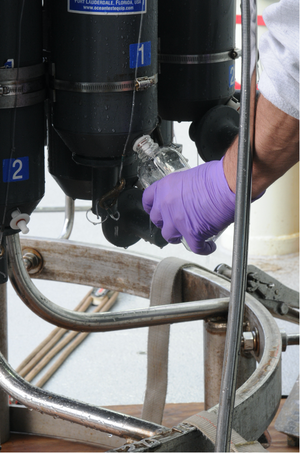
[caption id="attachment_20259" align="alignleft" width="199"] Collecting water samples from the CTD rosette on the Pioneer 8 cruise aboard the R/V Neil Armstrong. ©WHOI.[/caption]
To make these data more easily accessible to the science community, we have developed a common template to provide a full set of discrete water sample data from a cruise. These “Discrete_Sample_Summary” spreadsheets include the details for each Niskin bottle fired on a CTD cast, the CTD instrument rosette data from the time of bottle closure, and the water sample data and quality flags based on World Ocean Circulation Experiment (WOCE) standards.
These CSV files with common data formats can easily be read and manipulated in MATLAB, Python, or other computing programs and languages. Because water analysis data are received at different times from different labs, these spreadsheets are updated as data become available. An accompanying README file contains version history, general notes, and a description of the quality flags. The original spreadsheets from labs, which may contain additional data and methodology, will also be posted.
An example of how to read and use this discrete sample data can be found in this Jupyter notebook. Discrete_Sample_Summary spreadsheets have been posted for the Regional Cabled Array cruises 6-10, the Coastal Endurance Array cruises 1-13, and the Global Irminger Sea Array cruises 1-6. We will continue to work on completing spreadsheets for past cruises as well as cruises going forward.
[caption id="attachment_20261" align="aligncenter" width="640"]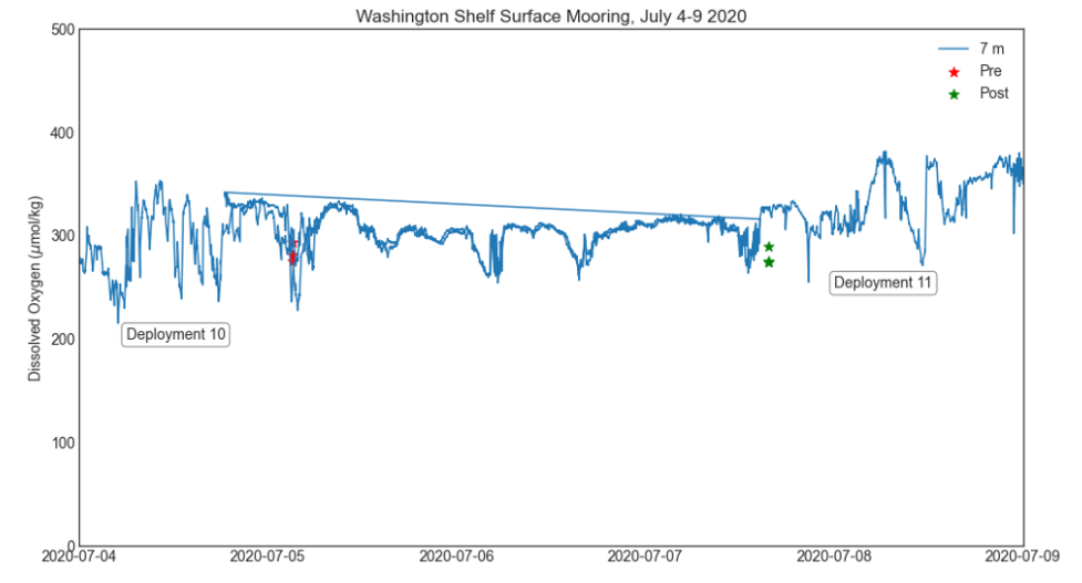 Comparison of dissolved oxygen data on the Washington Shelf Surface Mooring with water sampling data from Endurance Cruise 13. Data from Deployment 10 and Deployment 11 are plotted together, and overlap during 5-7 July.[/caption]
Read More
Comparison of dissolved oxygen data on the Washington Shelf Surface Mooring with water sampling data from Endurance Cruise 13. Data from Deployment 10 and Deployment 11 are plotted together, and overlap during 5-7 July.[/caption]
Read More Pioneer Data Complements Fisher-Collected Data to Explain Ocean Processes and Fish Distributions
Since 2014, fishers in southern Rhode Island and scientists from Woods Hole Oceanographic Institution (WHOI) have been working collaboratively to share data and learn from one another. For the past seven years, fishers have been collecting oceanographic data through the Commercial Fisheries Research Foundation’s (CFRF) Shelf Research Fleet and WHOI has shared data collected by the Pioneer Array.
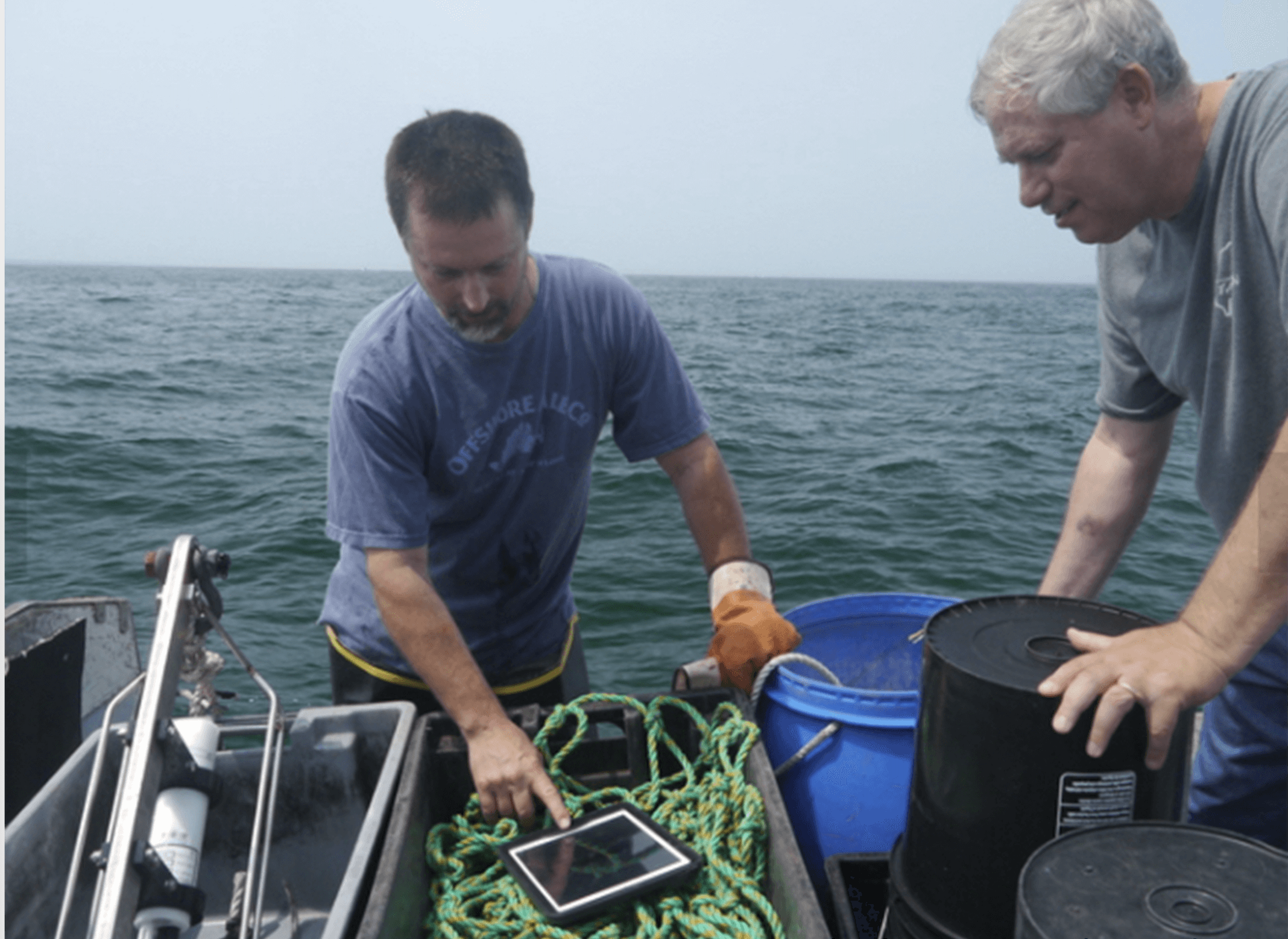
Through this partnership, fishers have come to value data from the Shelf Research Fleet and the Pioneer Array, as well as the insights of researchers who have spent years studying some of the most productive fisheries in U.S. waters. WHOI provides Pioneer data to fishers, and fishers provide oceanographic data collected during their normal fishing operations using CTDs which measure conductivity, temperature and depth information through the CFRF/WHOI Shelf Research Fleet. When the CTDs are brought onboard they wirelessly communicate the temperature data to an iPad where fishermen can view oceanographic conditions and ultimately upload the data to scientists. These CTD measurements provide the physical properties of sea water, which help determine the location and composition of the catch.
[caption id="attachment_20251" align="alignright" width="300"] Fisher Michael Marchetti (left) and WHOI scientist Glen Gawarkiewicz discuss data collected by a portable CTD. Credit: Commercial Fisheries Research Foundation.[/caption]
“This arrangement is a good example of how if people are willing to listen and really learn to value issues that are going on for another group, remarkable things can occur,” said Glen Gawarkiewicz, a WHOI researcher who leads the CFRF -WHOI Shelf Research Fleet.
In December, Gawarkiewicz visited the sea surface temperature website maintained by Rutgers University. There he noticed a sea surface temperature image that seemed to suggest a patch of warm, salty water known as a warm core ring forming directly adjacent to the continental shelf in the vicinity of the Pioneer Array. Warm core rings form when the Gulf Stream becomes unstable. These meanders can break off forming a swirling mass of water dozens of miles across, with warm water at the center that can be transported away from the Gulf Stream and into normally cold coastal waters of New England. Once there, such eddies can disrupt ecosystems and affect weather patterns for weeks.
[caption id="attachment_20250" align="alignleft" width="300"]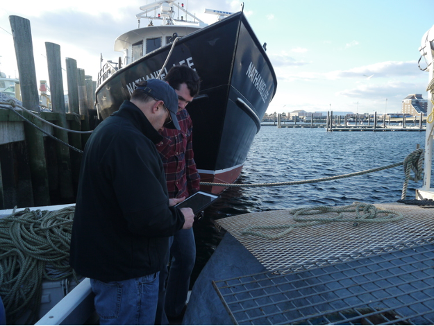 Newport Rhode Island lobsterman James Violet (foreground) reviews oceanographic data collected via CTDs on WHOI provided iPads. Credit: Commercial Fisheries Research Foundation.[/caption]
Gawarkiewicz then went to the Ocean Observatories Initiative data portal and made plots that confirmed the existence of high-salinity surface water near one of Pioneer’s offshore moorings and near the seafloor of one of the array’s inshore moorings. The conditions, he said, were very much like an event in January 2017 in which fish normally associated with warm Gulf Stream waters were caught near Block Island. The event in January 2017 was initially identified in Shelf Research Fleet data and then confirmed in Pioneer Array glider data analyzed by Robert Todd of WHOI.
Acting on the solid relationship built between WHOI and the CFRF, Gawarkiewicz emailed CFRF staff to warn them that conditions were changing and that they should be on alert for changes in the fishery. Shortly after, he received a phone call from Shelf Fleet collaborator, Aubrey Ellertson, who had reported that fishers were noticing an increase in water temperature on the bottom of the seafloor, and an impact on their catch. For some fishers, the Jonah crab fishing declined, and for others they were not seeing traditional fish species caught in their gillnets.
This exchange highlights the strong partnership between WHOI and the Rhode Island fishing fleet. The collaboration has helped participating fleet members recognize oceanographic processes and relate their fishing catch to processes discussed with WHOI scientists like Gawarkiewicz, and his colleagues Magdalena Andres, Ke Chen, and Massachusetts Institute of Technology/WHOI Joint Program graduate Jacob Forsyth. At the same time, Gawarkiewicz and his team have learned from the fishing community about the impacts of warm core rings on species distribution, their catch and, more broadly, on the shelf ecosystem.
“I knew to pass along this alert because members of the Shelf Research Fleet have taught me about what fishing outcomes are likely from some changing ocean conditions,” said Gawarkiewicz. “It is truly remarkable how much we have been able to learn from each other.”
Gawarkiewicz believes that this event demonstrates both the practical and intellectual value of the Pioneer Array data in improving understanding of sub-surface exchange processes. “Without Pioneer, we would not know the bottom salinity nor been able to give the fishers a heads-up as to what to expect. This shows how Pioneer is having a direct impact on how, when, and where people are fishing.”
To hear an audio piece with interviews with Gawarkiewicz, Aubrey Ellertson and others, listen here.
Read More
Community Expansion of the Regional Cabled Array
In 2016, the National Science Foundation (NSF) opened up opportunities for the community to submit proposals to add infrastructure/instrumentation onto the Ocean Observatories Initiative (OOI) marine facility and to use OOI data for research and educational purposes. Following this call, there was a rapid response from researchers to expand the Regional Cabled Array (RCA) with additional funding from the Office of Naval Research (ONR), NASA, and the international community. As of 2021, over $36M has been awarded from these sources for research and education associated with the RCA. Sixty-five awards have been made to 66 Principal Investigators (PI) and Co-PIs representing 32 institutions and 2 industry partners.
Axial Seamount: A Hot Bed of Research
Axial Seamount is the most advanced submarine volcanic observatory in the oceans and has been the focus of numerous awards with a diverse funding portfolio. Infrastructure within the caldera currently includes 21 core instruments, funded through the OOI, and 8 PI instruments now installed and another 4 to be installed in 2021-2022. In concert, this instrumentation is yielding new insights into the dynamics of Axial Seamount’s magmatic system, diking-eruptive events, and linkages among seismic, hydrothermal, and chemical processes; and is providing the first forecasting capabilities on when this highly active volcano will erupt again.
Central Caldera
[caption id="attachment_20234" align="alignleft" width="300"]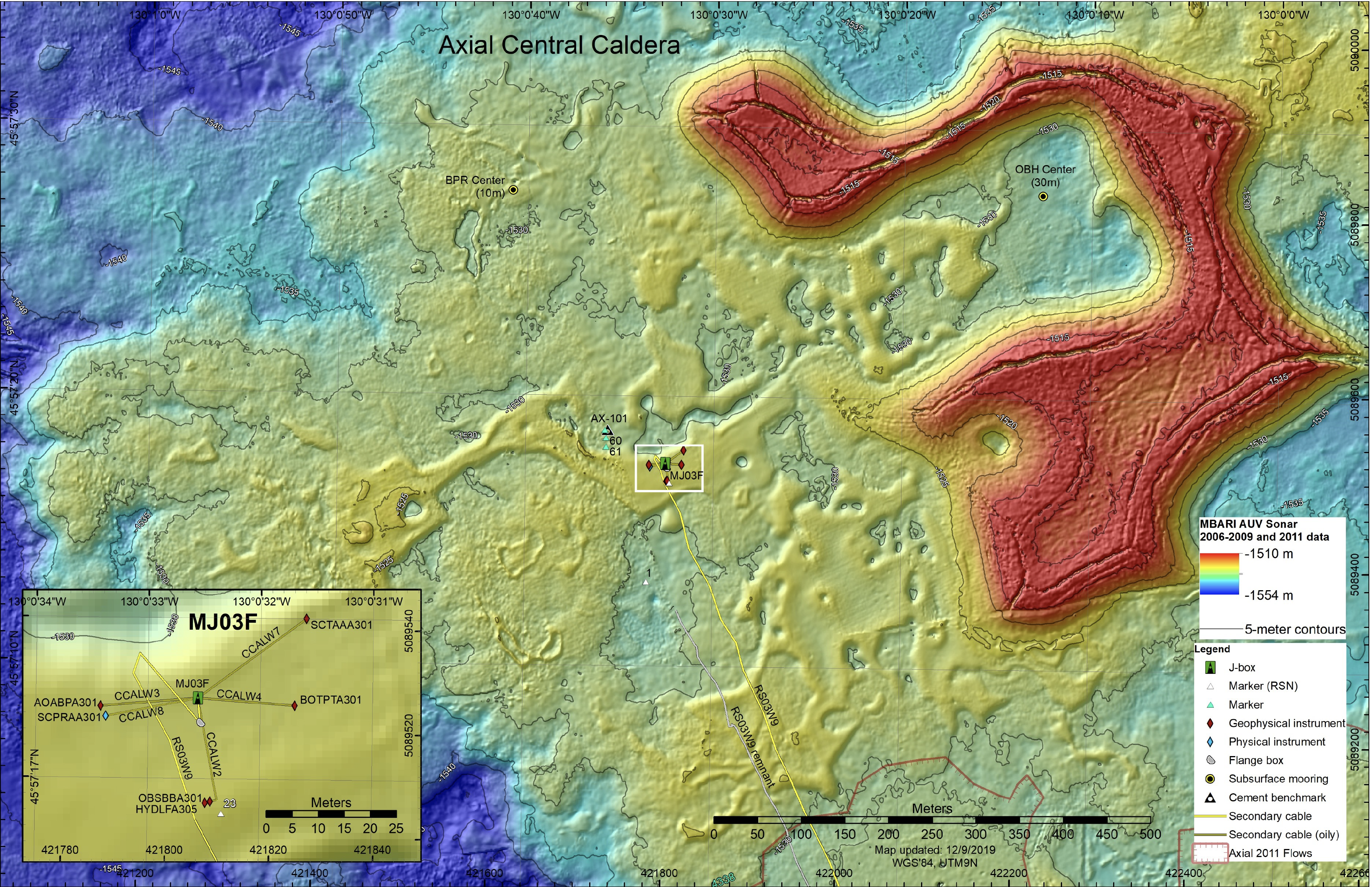 RCA infrastructure and NSF-funded PI instruments at Central Caldera as deployed in 2019. Credit: University of Washington.[/caption]
At the summit of Axial, the Central Caldera site has become an important research site for development and testing of geophysical instruments with focus on geodetic applications. RCA core instruments at this site include a bottom pressure-tilt instrument, a broadband seismometer and low frequency hydrophone. Here, three novel PI instruments, funded by the NSF, measure vertical changes in the seafloor at high resolution with removal of drift in pressure measurements.
These instruments include: 1) a Self-Calibrating Pressure (SCPR) recorder using an internal drift free pressure reference (Drs. M. Zumberge and G. Sasagawa, Scripps Institution of Oceanography), which was installed in 2018 with data now available through OOI;
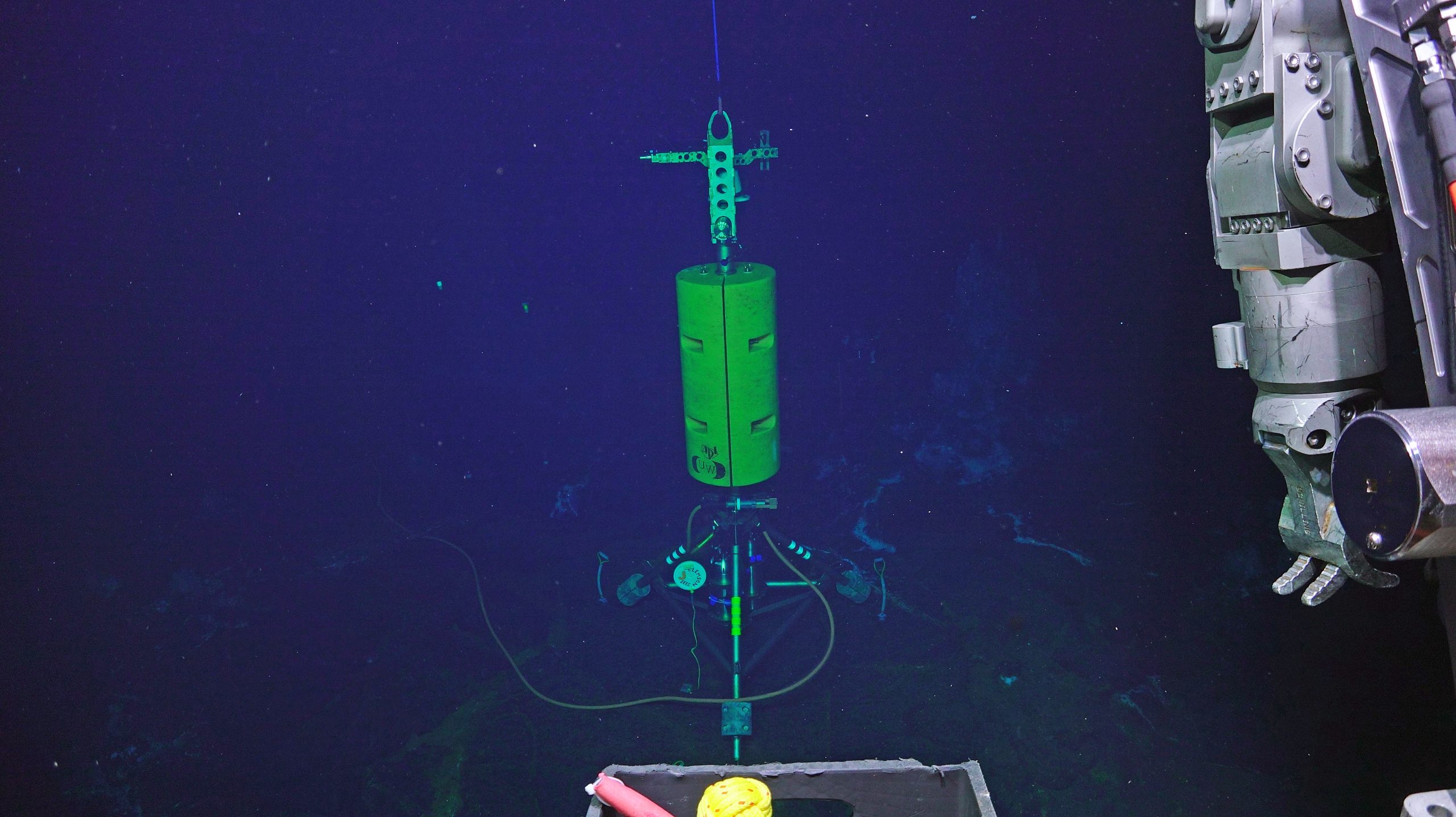
[caption id="attachment_20232" align="alignright" width="300"]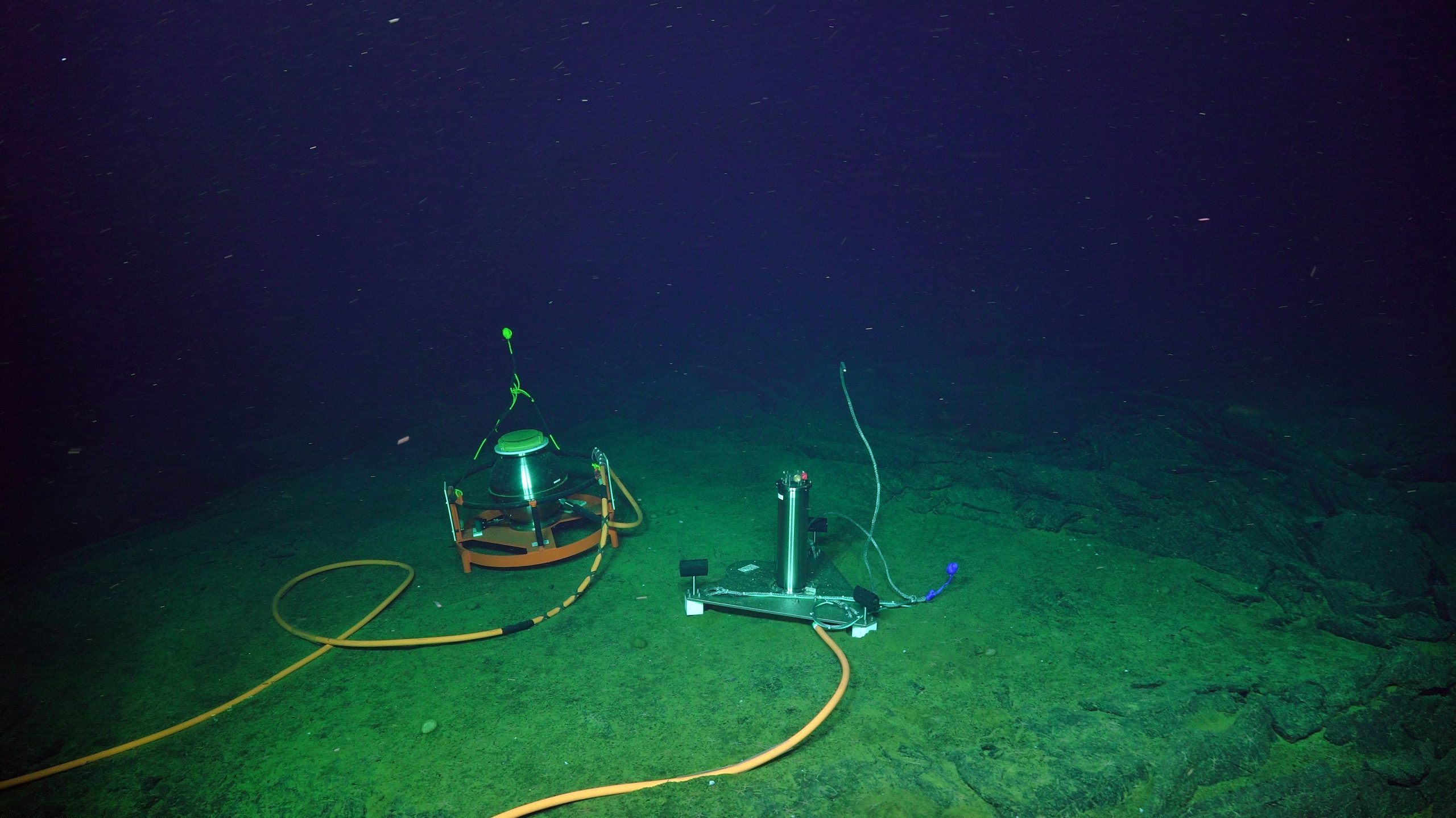 The Self-Calibrating Pressure Recorder (left) sits adjacent to the A-O-A instrument allowing cross comparison of data focused on seafloor deformation. Credit: UW/NSF-OOI/WHOI; V19.[/caption]
2) a flipping tilt meter (SCTAA) (Dr. W. Wilcock, University of Washington) installed in 2018 that corrects for instrument drift by calibrating the sensor against the Earth’s gravitational force using a high-resolution three-component quartz accelerometer; and 3) an ‘A-O-A’ instrument (Dr. W. Wilcock, University of Washington) installed in 2019, which uses a valve to switch an internal pressure sensor from measuring the pressure in the ocean to that inside the instrument housing to allow for correction of sensor drift. It is anticipated that this instrument will have applications to follow-on geodetic studies of the Cascadia Subduction Zone.
[caption id="attachment_20233" align="alignleft" width="300"]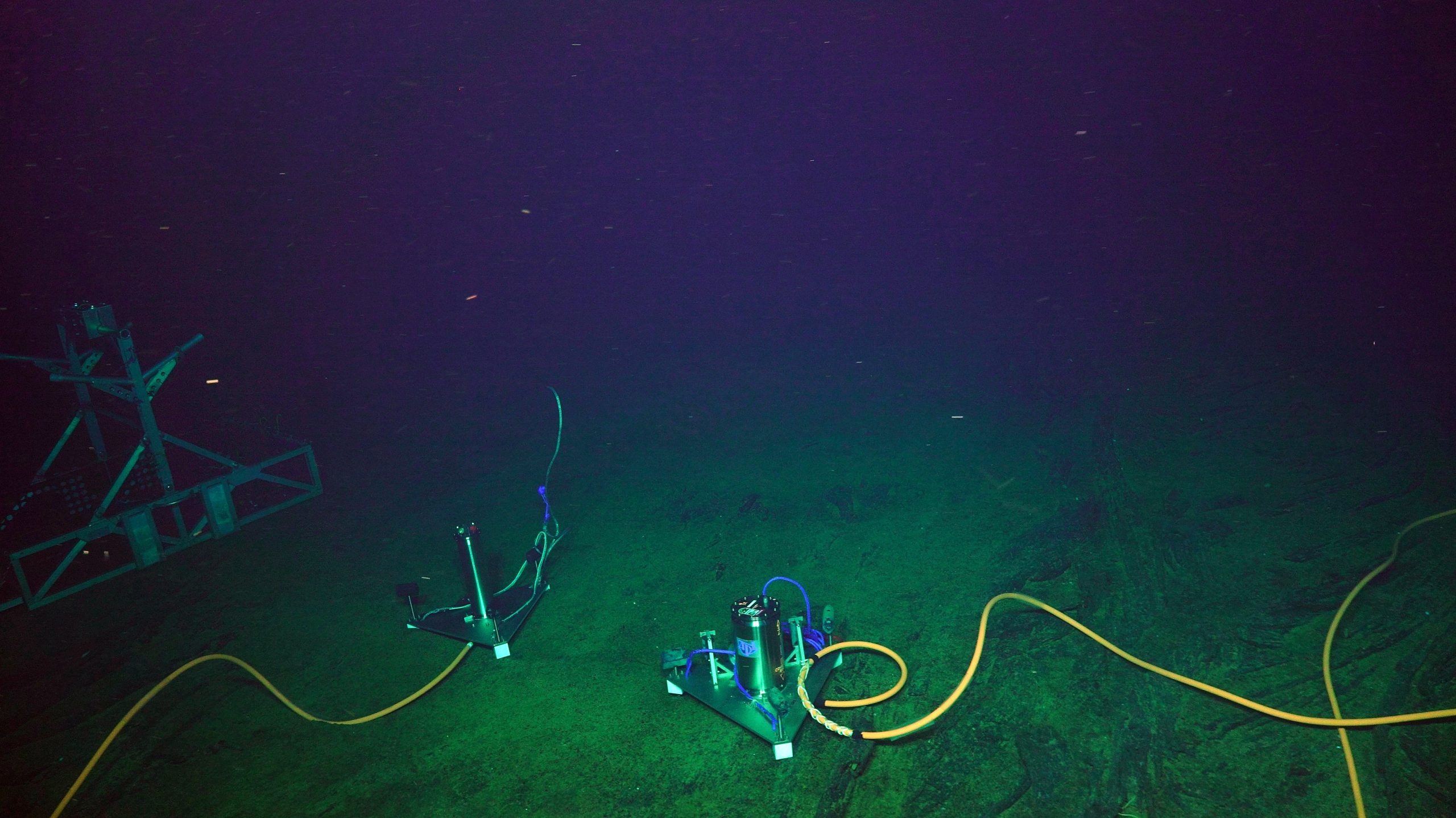 The NSF-funded Flipping Tilt Meter (right) and A-O-A instrument in 2019. The A-0-A instrument was moved to be adjacent to the Self Calibrating Pressure Recorder. Credit: UW/NSF-OOI/WHOI; V19.[/caption]
These three instruments and the OOI bottom pressure-tilt instrument are all installed within 50 meters of each other, providing an unparalleled opportunity for cross comparison of the real-time continuous data. In addition to the geophysical suite of instruments, a CTD instrument will be installed at this site in 2021 (see below; Dr. W. Chadwick, Oregon State University).
ASHES Vent Field
[caption id="attachment_20229" align="alignleft" width="243"]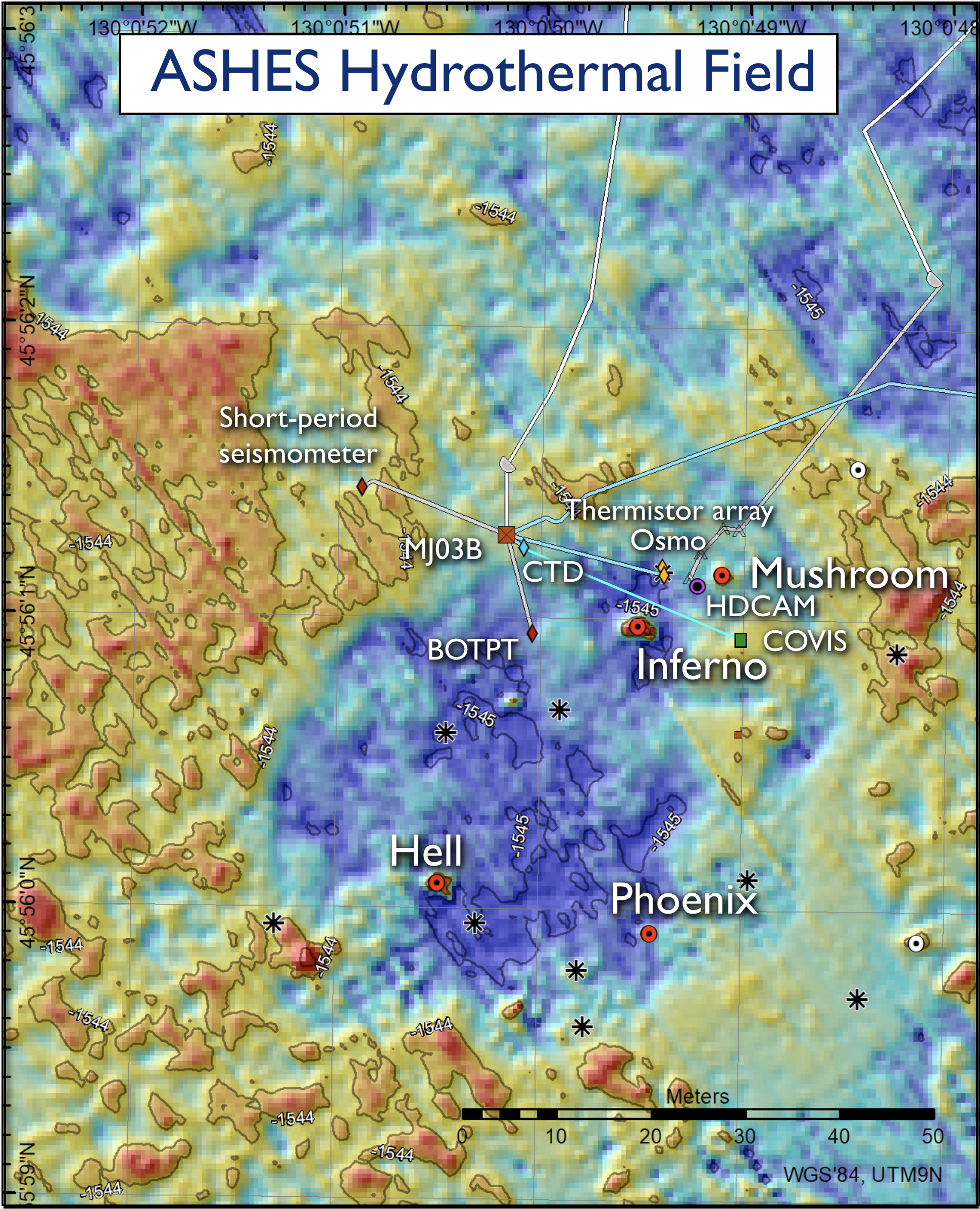 Regional Cabled Array infrastructure at ASHES in 2019. Also shown are the PI NSF-funded instruments (COVIS and CTD) and the location of high temperature vents (red dots) Credit: University of Washington.[/caption]
The ASHES vent field, located near the western wall of Axial Seamount, is a site focused on investigating the impacts of seismicity on fluid flow, quantitative measurement of the flux of fluids and heat from vents, evolution of sulfide chimneys and biological communities, and development of instrumentation for life detection.
Here, RCA core infrastructure includes an HD video camera imaging the actively-venting, animal-covered edifice called ‘Mushroom’ – live streaming of video occurs every three hours for ~ 14 minutes daily, two times a month for 24 hours, and once a month for 72 hours. In addition, there are two short-period seismometers located ~20 meters and 1200 meters from the field, a bottom pressure-tilt instrument, and a novel 3D temperature array with 24 sensors that is co-installed with an osmotic fluid sampler for time-series chemical measurement of diffuse flow.
PI- provided instruments at ASHES include an NSF-funded CTD installed in August 2017 (Dr. W. Chadwick, Oregon State University), which is one of three located within the caldera of Axial Seamount to investigate the emission of subsurface brines from the seafloor (Xu et al., 2018). Another CTD was installed in 2020 on the Eastern Caldera junction box. These data are available through OOI.
An NSF-funded cabled multibeam sonar system (COVIS – Cabled Observatory Vent Imaging Sonar – Dr. K. Bemis, Rutgers University) that was installed in 2018, which has resulted in the first long-term, quantitative monitoring of plume emissions.
[caption id="attachment_20228" align="alignleft" width="300"] The COVIS sonar platform as installed in 2019 in the ASHES Hydrothermal Field. The sonar is focused on plume emissions and diffuse flow proximal to the hydrothermal chimneys Mushroom and Inferno. Credit: K. Bemis/Rutgers/UW/NSF/WHOI; V19.[/caption]
This platform stands over 4 m above the seafloor and images plumes proximal to the actively venting ‘Inferno’ and Mushroom chimney located 10 m away, as well as sites of diffuse flow. Sonar data coupled with in situ thermal measurements document significant changes in plume variations, and modeling results indicate a heat flux of 10 MW for the Inferno plume (Xu et al., 2020). Multibeam data and data products are available through OOI. COVIS will provide key data to the community investigating the impacts of eruptions on hydrothermal flow. A NASA-funded and cabled state-of-the-art platform called InVADER (In-situ Vent Analysis Divebot for Exobiology Research; P. Sobron, SETI Institute) hosting a spectroscopic laser and 3D imaging system will be installed in 2021 on the south side of Inferno. The purpose of this award is to advance technologies, real-time sensing, and mission execution applications in hydrothermal systems to further exploration and the study of vent environments on other ocean worlds.
[caption id="attachment_20237" align="alignright" width="246"]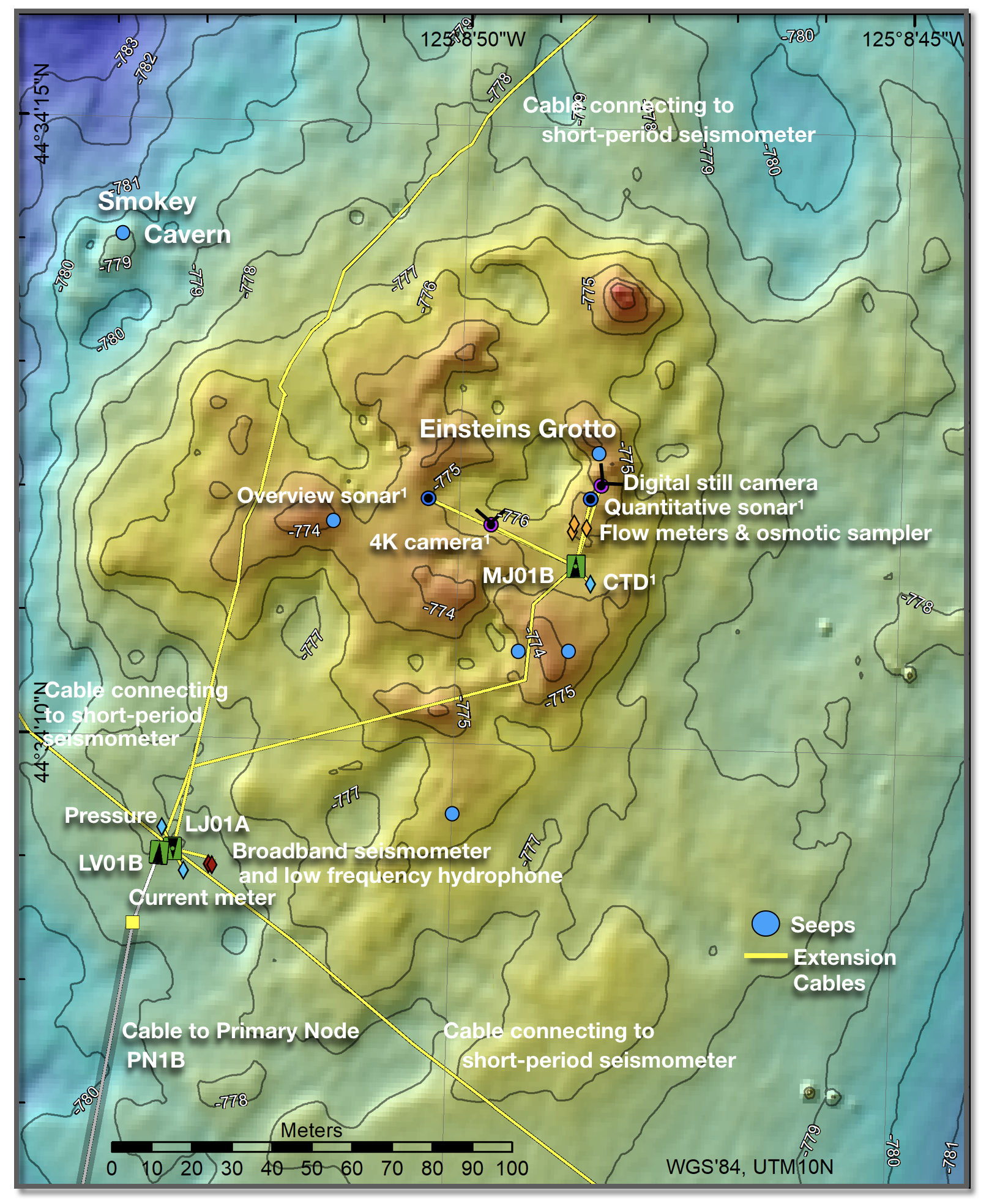 RCA infrastructure at Southern Hydrate Ridge as installed in 2019. Also shown are instruments funded by MARUM (2 sonars, 4K camera, and a CTD). Credit: University of Washington.[/caption]
Southern Hydrate Ridge: Methane Ice, Seafloor Collapse and Dynamic Plumes
The cabled Southern Hydrate Ridge (SHR) site is one of the best studied methane hydrate systems in the oceans and it has been designated as an essential fish habitat. RCA infrastructure installed at the summit of the ridge includes a suite of 11 instruments to investigate the evolution of this highly dynamic system hosting multiple sites of bubble emission from the seafloor; a rapidly evolving topography marked by extremely hummocky terrain and rapidly forming collapse pits; and, at times, exposed hydrate on the seafloor. An array of short-period seismometers and a buried broadband seismometer provide real-time data on far-field and local seismicity. One goal for the triangular array of seismometers was to inform on subsurface plumbing through bubble formation.
Since 2014, Einstein’s Grotto has been the focused RCA experimental site hosting a digital still camera, flow meters, an osmotic fluid sampler, mass spectrometer, and an ADCP for imaging of the plume. Einstein’s Grotto is currently unrecognizable from when first surveyed, having transformed from a gentle hummock to a large collapse pit from which explosions of bubbles and entrained flocculant and sediment occurred in 2011, partial collapse of the pit in 2015, and, most recently, a much more subdued topography in 2020. Exposed methane hydrate within the pit has been viewed here on multiple cruises. Over the decade of imaging during RCA cruises, there has also been a dramatic change in the location, density, and thickness of bacterial mats around this area.
[caption id="attachment_20238" align="alignleft" width="214"]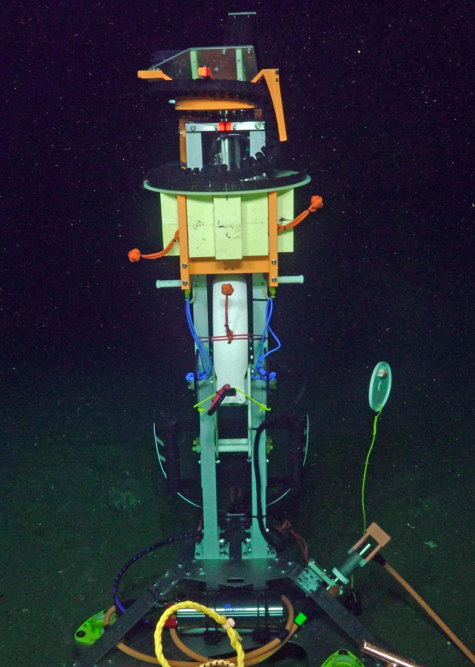 This rotating overview sonar (R2Sonic 2022) provides 360° imaging of all bubble plumes issuing from the summit of Southern Hydrate Ridge. Credit: MARUM/UW/WHOI; V18.[/caption]
In 2018, a multi-year program “Sonar Monitoring of Natural Release of Methane Greenhouse Gas from the Seafloor – A Contribution to the Understanding of Global Change” funded by the German Ministry of Education and Research (Drs. G. Bohrmann and Y. Marcon, University of Bremen) resulted in the installation of instruments at SHR to quantify the flux of methane and bubble plume dynamics at this site. A ~3.6-meter-tall platform hosting a rotating multibeam sonar provides a 700 m across, 360° view of all bubble plumes emitted at the summit including their intensity and rise height. Scans are conducted about two hours apart. Also installed was a quantification sonar aimed at measuring gas flux and changes in seafloor topography proximal to Einstein’s Grotto. The quantification sonar is on a 2.6-meter-tall tripod that conducts 360° scans of the local water column. In 2019, this infrastructure was augmented by the addition of a cabled 4K camera and CTD. All instruments were recovered in 2020 and will be reinstalled in 2021.
[caption id="attachment_20239" align="alignright" width="300"]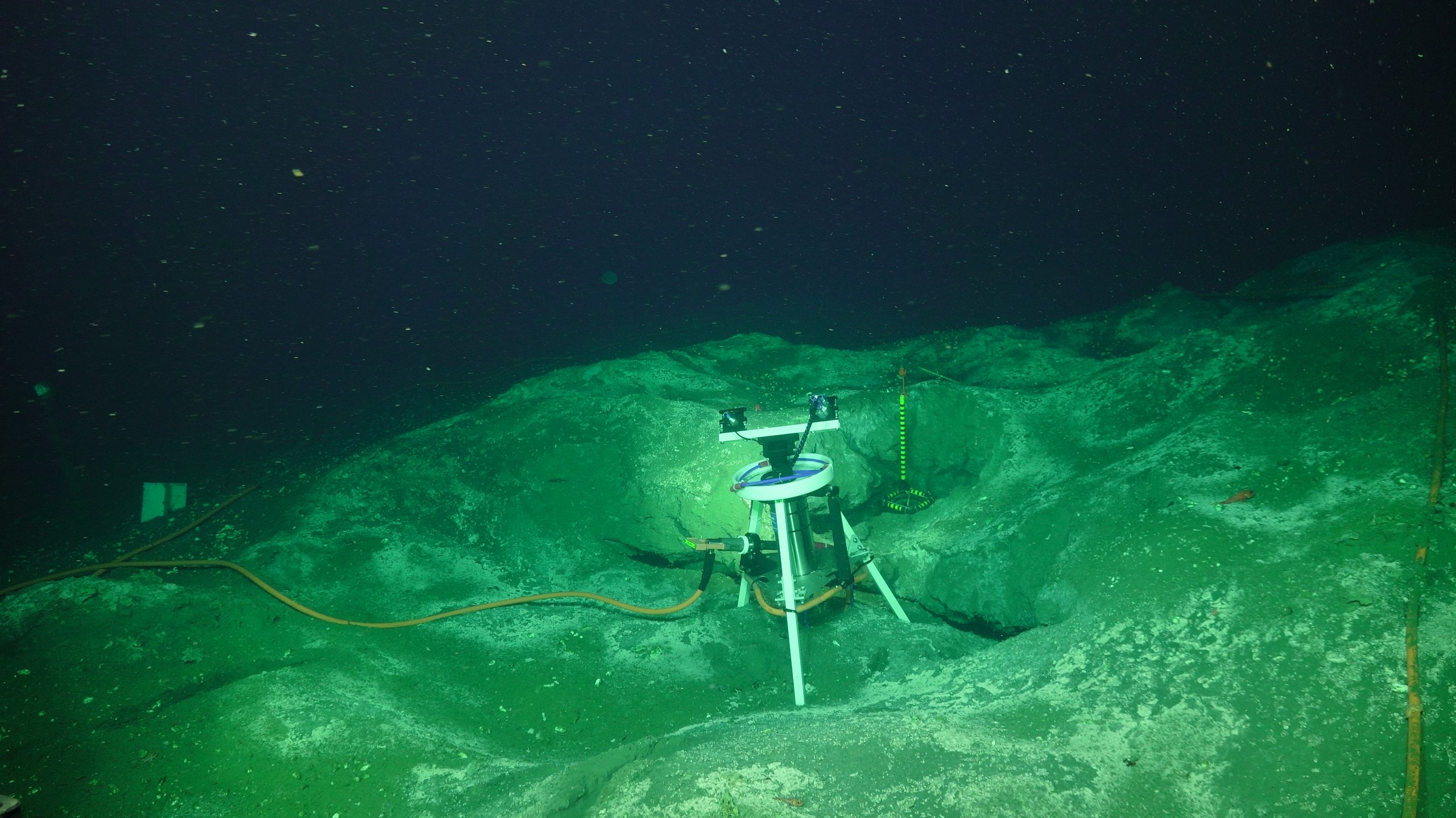 This 4K camera is focused on imaging the area proximal to Einstein’s Grotto. The area has changed remarkably over the past decade. Credit: MARUM/UW/WHOI; V19.[/caption]
From 2019-2020, an uncabled microbial fuel cell (CH4-Benthic Observer Platform), funded by the Office of Naval Research, was installed on a microbial mat near Einstein’s Grotto, which included two osmotic fluid samplers (Dr. C. Reimers, Oregon State University). Finally, a new NSF award “Collaborative Research: Investigating the source and flux of dissolved organic carbon released from methane seeps to the deep ocean (Dr. L. Lapham, University of Maryland Center for Environmental Sciences) will result in the deployment of additional osmotic fluid samplers for continuous sampling of SHR seep fluids.
During the initial planning stages of the RCA, a key requirement in the design was to include significant expansion capabilities and power. In four years, the need for this requirement has been clearly demonstrated by the significant response from the community. At the 2016 OOI Design and Implementation Workshop in Salt Lake City, Utah, Dr. Margaret Leinen (Scripps Institution of Oceanography and University of California San Diego), then Associate Director for Geosciences, gave the keynote talk. In this presentation, she said “If you build it, they will come”…a prediction that has come to fruition with innovative and synergistic research into deep ocean processes focused on the cabled array.
This article was written by Deborah Kelley, Principal Investigator for the Regional Cabled Array.
Read More
NSF Webinar on Center for Advancement & Synthesis of Open Environmental Data & Sciences Competition

On February 23, 2021 at 3:00 PM EST, NSF will host a one-hour webinar to provide information concerning the competition for a Center for Advancement & Synthesis of Open Environmental Data & Sciences (NSF 21-549). The National Science Foundation’s (NSF) Divisions of Biological Infrastructure (DBI), Environmental Biology (DEB), and the Office for Advanced Cyberinfrastructure (OAC) are hosting the webinar. Following a brief presentation, program directors will be available to answer questions from participants.
Open biological and other environmental data are produced by NSF investments in research and infrastructure such as the National Ecological Observatory Network (NEON), the Ocean Observatories Initiative (OOI), the Long-Term Ecological Research (LTER) network, and the Integrated Digitized Biocollections (iDigBio), as well as by many other public and private initiatives in the U.S. and worldwide. These efforts afford opportunities for collaborative investigations that will advance our predictive understanding of life on Earth; publicly available data are burgeoning. Access to and creative use of these data can democratize science and diversify the STEM workforce as never before by making the same data available to and usable by everyone, from collaborative teams of experts to individual students, researchers, educators and policy makers.
In response, NSF seeks to establish a Center fueled by open and freely available biological and other environmental data to catalyze novel scientific questions in environmental biology through the use of data-intensive approaches, team science and research networks, and training in the accession, management, analysis, visualization, and synthesis of large data sets. The Center will provide vision for speeding discovery through the increased use of large, publicly accessible datasets to address biological research questions through collaborations with scientists in other related disciplines.
Register in advance for this webinar:
https://nsf.zoomgov.com/webinar/register/WN_YvILcBaDRSWB6fCtbR6cAg
Or an H.323/SIP room system:
H.323: 161.199.138.10 (US West) or 161.199.136.10 (US East)
Meeting ID: 161 025 1954
Passcode: 179784
SIP: 1610251954@sip.zoomgov.com
Passcode: 179784
After registering, you will receive a confirmation email containing information about joining the webinar.
Contact: Hannah Perry hanperry@nsf.gov
Read More
Endurance Array Measures Impact of Forest Fire Smoke
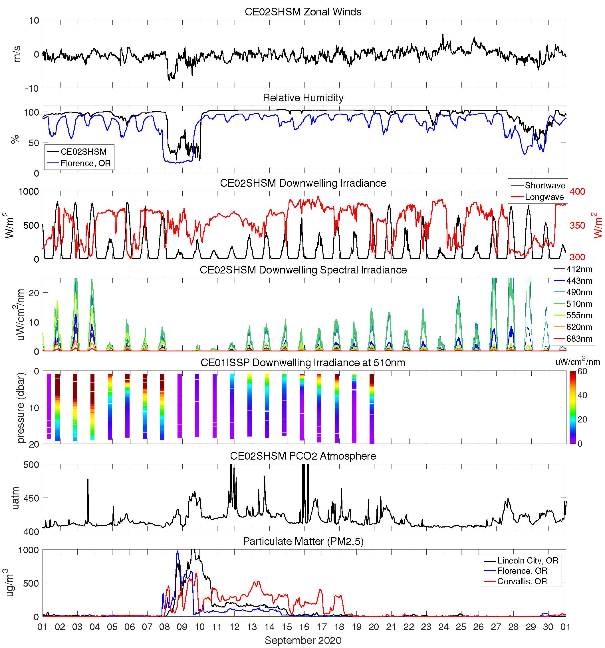
On September 8th 2020, wildfires spread quickly across western Oregon causing tremendous damage and shrouding the region with smoke for more than a week. Smoke from these fires, driven by an extreme Santa Ana-type easterly wind event, could be seen from satellites (figure 1). The smoky air moved directly across the path of the Coastal Endurance Array. A data view of this phenomenon is available here.
[caption id="attachment_20182" align="aligncenter" width="450"] The impact of the strong, dry offshore winds was measured by Coastal Endurance Array sensors shown here.[/caption]
Beginning on the 8th, strong, dry offshore winds blew past the Oregon Shelf Surface Mooring (CE02SHSM) 10 nautical miles west of Newport, which measured the lowest relative humidity values (<18%) since it was first deployed in April 2015 (panels a & b). These winds were followed by a week of reduced sunlight (panel c). Six meters below the surface, sunlight was reduced by the red smoke more in some colors than in others (panel d). Closer to shore at the Oregon Inshore site, light levels were measured throughout the water column by an OOI coastal surface piercing profiler (panel e). The smoky air had relatively high concentrations of carbon dioxide (panel f). Other Coastal Endurance Array sensors, such as bioacoustic sonars, also may have measured additional effects from these fires.
At the coast, the smokiest air cleared after a few days, although air particulates were elevated for more than a week (panel g). During the worst of the smoke, the iconic bridge over Yaquina Bay in Newport was hardly visible (figure 2). In Corvallis, 100 km inland and in the center of the Willamette Valley, unhealthy air blanketed the town for 10 days. These measurements are but one example of the type and quality of data being continuously collected by the Coastal Endurance Array.
[caption id="attachment_20185" align="aligncenter" width="640"]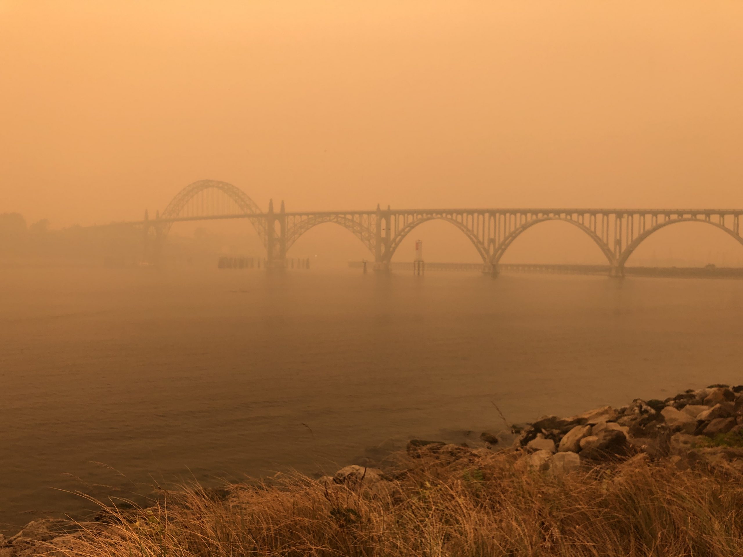 Figure 2. The Yaquina Bay Bridge was shrouded in smoke during an early October fire. Credit: Dr.Liz Perotti[/caption]
This article was written by Craig Risien and Jonathan Fram of the Coastal Endurance Array team.
Non-OOI data sources
NASA satellite images: https://earthobservatory.nasa.gov/images/147261/a-wall-of-smoke-on-the-us-west-coast
Florence air quality: https://oraqi.deq.state.or.us/home/map
Corvallis and Lincoln City air quality: https://www.purpleair.com/
Read More
New OOI Science Plan Now Available
The Ocean Observatories Initiative (OOI) Science Plan: Exciting Opportunities Using OOI Data is now available. This OOI Science Plan articulates the exciting research, educational opportunities, and pathways to advancing the understanding of high-priority science questions using OOI data. Specifically, the Plan is intended to inspire and enable the research endeavors of ocean scientists and educators, encourage collaborations, and motivate the training of future generations of scientists.
The document highlights the broad science themes and provides examples of important multidisciplinary science questions that require the OOI’s novel technology. Sidebars from scientists using OOI data illustrate the novel approaches being used to address long-standing science questions that are hard to address using ship-based expeditionary practices. The Science Plan includes a high-level synopsis of the current ocean network, the OOI program management, and data quality control and delivery. Innovative platforms and technologies are highlighted, as well as best practices developed by the OOI program. The Plan includes examples of educational opportunities and new applications provided by OOI data and ocean observing concepts. Community Engagement activities promoted by the OOI are featured. The document describes the ways in which current U.S. interagency partnerships and international collaborations make use of the OOI network in unique ways. Finally, information on how scientists and educators can participate in the OOI is provided.
The OOI Science Plan is available on the OOIFB website here.
For those preparing applications for the Pioneer Array Innovations Lab, this Science Plan could be a useful resource.
Read MoreQuestions about Potential Pioneer Array Move Answered
On Wednesday 13 January, the National Science Foundation and the Ocean Observatories Initiative Facilities Board held a microlab to answers questions about the process for deciding if, and if so where, the Pioneer Array might be relocated. The microlab was designed to provide potential applicants with information about the selection process as well as technical details about the Pioneer Array to be considered for potential new locations.
All feasible location options will be considered – new geographic areas, as well as maintaining the Pioneer Array in its current location – during a two-phased Innovation Labs, which all are invited to apply to participate in. Selection of a new OOI Pioneer Array location will be driven by community input on the important science questions that can be addressed with observations from a new Array location.
The answers to the questions posed during the microlab will be helpful to all potential applicants. The answers can be found here.
Read More