
News
Enhancing Infrastructure Usability: Updates to the OOI Platforms and Nodes Page
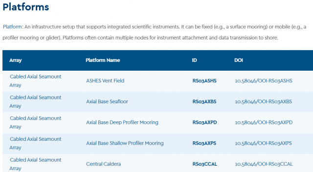
OOI has implemented a series of significant updates to its Platforms and Nodes webpage, aimed at improving sensor usage traceability, infrastructure identification, and research reproducibility. These enhancements directly support the scientific community’s need for clear, accessible metadata and a more streamline connection between OOI platforms and the data they produce.
The updated Platforms and Nodes List provides a complete and structured inventory of all deployed infrastructure across the OOI’s Coastal, Global, and Cabled arrays. Each array name links to a comprehensive description of its design, geographic focus, and research themes. Individual platforms are now associated with dedicated landing pages that correspond to their official Digital Object Identifiers (DOIs) which establishes a clear and citable connection between physical infrastructure and the data it generates.
These platform-specific landing pages serve as centralized reference hub for each infrastructure component. They include standardized citation guidance to support accurate attribution, direct access to relevant datasets and data portals, and detailed descriptions that place each platform in scientific and operational context. Each page also features a complete list of associated instruments, with links directing users to either the OOI Data Explorer or the appropriate data access interface, facilitating efficient navigation to raw and derived data streams.
These updates provide researchers with a more cohesive and transparent framework for data discovery and usage. By enabling precise cross-referencing of platforms, instruments, and datasets, the new infrastructure makes it easier to do many types of scientific research, including tracking changes over time, checking models against in situ data, studying specific ocean processes across platforms, and combining data from different platforms for more in-depth analysis.
The improvements reflect OOI’s ongoing commitment to making its data and infrastructure more FAIR (Findable, Accessible, Interoperable, and Reusable). By reinforcing the connection between deployed equipment and accessible data products, this update enhances reproducibility and strengthens the integrity of research conducted using OOI assets.
Researchers are encouraged to explore the updated Platforms and Nodes page and incorporate these resources into their data workflows, citation practices, and project planning. These tools aim to simplify the process of finding data while also enabling more detailed and meaningful research using OOI’s distributed network of ocean observing systems.
Read MoreNSF CI Compass: OOI Data Delivery User Experience
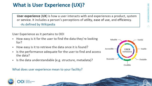
During a recent NSF CI Compass webinar, Jeffrey Glatstein, OOI Senior Manager of Cyberinfrastructure at WHOI, gave an inside look at how OOI has been rethinking and improving its approach to data delivery. His talk, “Data Delivery User Experience: Is it important to your facility?”, explored how the team has been working to make OOI’s massive data sets more accessible and usable for researchers and stakeholders.
Jeff oversees data systems that handle real-time streams from 900 instruments spread across 80 platforms. Altogether, OOI manages over 175 billion rows of data, 2.8 petabytes of raw data, and more than 13,000 hours of video. Jeff’s team is responsible for ensuring it remains readily accessible and usable by the research community.
Before the overhaul, users relied on a legacy portal called OOINET. While it provided basic functionality, it wasn’t always user-friendly. Users frequently cited long wait times, confusing interfaces, and difficulty locating specific data. These challenges sparked a full-scale effort, beginning in 2018, to improve the user experience from the ground up.
The approach placed strong emphasis on the user experience. Jeff and his team conducted interviews, reviewed previous feedback, and dug into system analytics to identify areas needing improvement. They looked at a range of technical solutions before ultimately partnering with Axiom Data Science to implement a new data access platform – what we now know as the OOI Data Explorer.
The webinar highlighted some of the major tech upgrades involved: Kafka for better message streaming, JupyterHub for advanced data access, Grafana for monitoring, and ERDDAP to improve data delivery. But what really set the project apart was its focus on making things easier and faster for users. Instead of relying only on on-demand plots, the new Data Explorer offers pre-generated visualizations and quicker access to datasets. Search tools were also upgraded, making it easier for users to find exactly what they’re looking for.
Scientists are now able to submit more precise queries, navigate the system with greater confidence, and achieve more effective search results. Jeff noted that the team remains focused on further enhancing the interface, broadening search capabilities, and streamlining the data download process to ensure an even better user experience.
Although Data Explorer has already delivered significant improvements, Jeff emphasized that OOI remains committed to continually enhancing overall functionality. These ongoing efforts reflect a broader mission: ensuring that the vast and valuable data collected from the ocean is not only accessible but also readily usable by the scientific community.
[caption id="attachment_36634" align="alignnone" width="640"] Credit: Jeffrey Glatstein[/caption]
[caption id="attachment_36637" align="alignnone" width="640"] Credit: Jeffrey Glatstein[/caption]
Read More
Credit: Jeffrey Glatstein[/caption]
Read More Why OOI Matters on World Oceans Day
Dear OOI Community,
Today, on World Oceans Day, we join scientists, educators, policymakers, and citizens around the globe to recognize the ocean’s critical role in sustaining life on Earth. From regulating climate to supporting biodiversity, the ocean is at the heart of our planet’s health and understanding it has never been more urgent.
That’s where the Ocean Observatories Initiative (OOI) comes into play.
For over a decade, OOI has enabled transformative ocean science by delivering open, continuous, research-quality data from some of the most dynamic and remote marine environments. Our coastal, global, and cabled arrays provide essential data that fuels research on everything from climate variability to marine heatwaves, earthquakes, ocean acidification, and more. OOI data supports students in classrooms, early-career researchers, seasoned scientists, and international partners.
But this World Oceans Day arrives with a tremendous amount of uncertainty.
As you may know, the President’s FY2026 budget request for the National Science Foundation (NSF) proposes severe cuts to OOI funding, up to 80%, along with language signaling possible decommissioning. These cuts would effectively end our ability to deploy sensors, maintain arrays, and collect new data. It would mark a significant loss for the ocean science community, especially at a time when sustained ocean observations are more important than ever.
Despite these challenges, our mission remains clear: support ocean discovery, empower data-driven research, and serve the broader public good. We continue to carry out fieldwork and deliver data that advances science every day.
On this World Oceans Day, we invite you to explore OOI data, share your stories of how you use it, and help us raise awareness by using #OOIDataMatters on social media. Let’s reaffirm why long-term ocean observation is a public investment that’s worth protecting.
Thank you for being part of this community. We will share updates as new information becomes available.
With appreciation,
Jim Edson
Read MoreAdvancing Mooring Technology for Long-Term Ocean Observation
Advances in oceanographic mooring technology are critical to sustaining long-term, high-quality observations in some of the planet’s harshest environments. Moorings must now operate reliably over extended deployments, support increasingly sophisticated instrumentation, and withstand the growing impacts of extreme weather. To better understand recent progress and ongoing challenges in this field, we spoke with Alex Franks, Research Engineer at Woods Hole Oceanographic Institution (WHOI) and a key contributor to the Ocean Observatories Initiative (OOI).
Over the past three years, Franks and his team have introduced significant upgrades to OOI infrastructure – most notably enhancements in satellite telemetry, power generation and management systems, and the structural resilience of both surface and subsurface moorings. These improvements aim not only to extend deployment lifetimes and reduce maintenance needs but also to expand the scientific capabilities of moorings by accommodating higher-bandwidth data streams and more energy-intensive instruments.
This Q&A offers a detailed look at the evolving strategies behind mooring system engineering and the practical steps being taken to meet both scientific demands and environmental challenges.
- In the last 3 years, what have been the most notable improvements in remotely diagnosing and fixing mooring issues?
The biggest upgrade we’ve implemented recently is a new satellite telemetry module called the “Stream +” (Stream Plus). This allows us to communicate with the buoys in a faster and more streamlined manner. I would compare the upgrade being the difference between dialup and high-speed internet. This unit was originally tested on the Irminger Sea Surface Mooring deployed in 2024 and has now been deployed at the Pioneer Array on the Central Surface Mooring and one of the Profiler Moorings. With this increased ability to troubleshoot and interact, we are able to support high bandwidth instrumentation like the Mclane IFCB (Imaging Flow Cytobot) which takes pictures of phytoplankton in real time. We are able to download a subset of the images and adjust camera focus remotely now. OOI can now also accommodate proposals for more high bandwidth instrumentation on the buoy systems.
- What new features are you currently developing to further improve mooring system reliability?
The OOI Electrical Engineering group is currently focusing on reducing power consumption and increasing reliability of power generation systems on the Surface Moorings. Several systems are being optimized including individual instrument power supplies and Surface Mooring seabed-located multifunction node (MFN) power transmission. We are also upgrading the solar panels to harvest even more energy from the sun during long deployments. Lastly, the wind turbines on the Surface Moorings have been further ruggedized to help withstand the 20-meter waves and hurricane force winds that we observe at our global sites. A test of that redesign is underway at the Pioneer Array. All of these optimizations and upgrades will result in a mooring that can accommodate new power-hungry instrumentation, exceed our current sampling scheme, and withstand doldrums or high latitude winter with little to no solar generation.
At OOI we are also starting to think about more onboard computing power, more data storage, and more expandability in terms of available ports for new instrumentation. We always have our eye on streamlining our current electronics.
- Looking ahead, what do you see as the next major breakthrough in mooring technology?
I’m looking forward to testing solid state batteries as they are developed for use on mooring systems. The benefits of lithium with less safety concerns are very interesting to me. Losing battery weight and gaining more usable energy storage is a very attractive prospect.
- Are there any upcoming field tests or deployments that you’re particularly excited about?
OOI is partnering with Sandia Labs and the Department of Energy to develop and deploy a prototype of a wave energy converter on the Central Surface Mooring in fall of 2025. This device will be situated inside the buoy and convert wave motion into mooring power as proof of concept. This project has been going on for a few years now and it’s very rewarding to see it coming to fruition.
Advancements in mooring technology are directly improving data quality, reliability, and access for long-term ocean observations.
To explore available datasets and learn more about current system capabilities, visit oceanobservatories.org.
[caption id="attachment_36486" align="alignnone" width="320"]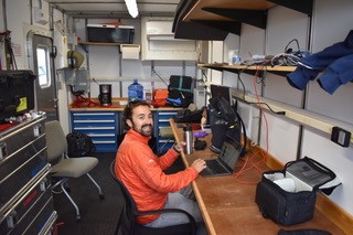 Compass characterization procedure at the LOSOS building. Pictured: Alex Franks, WHOI[/caption]
Read More
Compass characterization procedure at the LOSOS building. Pictured: Alex Franks, WHOI[/caption]
Read More Open Access, Open Ocean: Marking 75 Years of NSF Through Sustained Ocean Observation
This week, the OOI joins the scientific community in celebrating the 75th anniversary of the U.S. National Science Foundation (NSF). This milestone marks decades of national investment in science, innovation, and public benefit.
OOI exists because of NSF’s vision and support. Our mission, delivering long-term, openly accessible ocean data, reflects a shared commitment to expanding scientific knowledge and ensuring that access to that knowledge is equitable, inclusive, and available to all.
Open Access Data: A Shared Commitment
The NSF’s mission is rooted in the belief that the progress of science should benefit all and be free from barriers to participation. OOI carries this forward through its core function: providing open access to high-resolution oceanographic data collected from some of the most remote and dynamic regions of the ocean.
OOI’s infrastructure, which spans cabled, coastal, and global sites, captures continuous, multi-dimensional data on key ocean processes. This data, ranging from temperature and salinity to seafloor seismic activity, is made freely available in near real time to anyone: scientists, educators, students, and the public.
For both OOI and NSF, access to data isn’t just a technical feature, it’s a fundamental value. Transparency, inclusivity, and public benefit are central to how we operate.
Investing in Infrastructure
NSF invests in strengthening the nation’s ability to conduct research and turn scientific insights into benefits for society. OOI supports this by maintaining a robust, continuously operating network of ocean sensors and platforms. This infrastructure enables:
- Collaborative research across institutions and disciplines
- Technology testing and innovation in extreme marine environments
- Educational engagement using real-world datasets
- Data-driven decision-making on ocean and climate issues
OOI’s open access model makes it possible for anyone, from seasoned scientists to high school students, to use ocean data to ask questions and find answers.
A Model for Public Science
In a time when access to credible, timely data is more important than ever, OOI’s approach serves as a model for how federally funded science can empower public knowledge and innovation. By making data easier to access and use, we help to ensure that science reaches more people and that the benefits of NSF-funded research are shared more broadly.
Looking Ahead: Sustaining Discovery
As the NSF celebrates 75 years, we acknowledge its enduring contributions to scientific advancement and public understanding. Its support for open, collaborative research continues to play a crucial role in driving discovery and responding to the evolving questions shaping science today.
With the continued support of the NSF, OOI is honored to play a role in this shared mission. We remain committed to advancing ocean science, making ocean data widely accessible, and deepening understanding of the ocean’s impact on our planet.
Read More
Salinification of the Cold Pool on the New England Shelf

(Adapted from Taenzer et al., 2025)
The continental shelf within the Mid-Atlantic Bight is cooled and mixed vertically in the winter. This relatively cold, fresh water is trapped below the seasonally-warming surface layer, retaining its properties as a subsurface “cold pool” throughout most of the spring and summer. The cold pool is important for regional ecosystems, serving as a cold-water habitat and a nutrient reservoir for the continental shelf. It is known that the cold pool warms and shrinks in volume as a result of advective fluxes and heat exchange with surrounding waters. A recent paper by Taenzer et al. (2025) shows for the first time that the cold pool is also subject to salt fluxes and increases significantly in salinity from April to October.
The Pioneer New England Shelf (NES) inshore moorings (ISSM and PMUI) are positioned shoreward of the shelfbreak front and sample conditions on the outer continental shelf where the cold pool can be identified. The authors extracted data from these two moorings from a quality-controlled data set containing timeseries of hydrographic data (temperature, salinity and pressure) from all of the Pioneer NES moorings on a uniform space-time grid, covering the timeframe from January 2015 through May 2022 (Taenzer et al., 2023). The cold pool study used data from 2 m depth, 7 m depth, and 2 m above the bottom on ISSM and from roughly 28 m to 67 m depth on PMUI.
Seven years of data from the Pioneer ISSM and PMUI moorings were used to create a composite annual cycle, which showed that subsurface salinity on the outer shelf consistently increases in the spring and summer. Evaluating the 67 m depth salinity record, and restricting the time period to when the moorings are in the cold pool, resulted in a salinification estimate of 0.18 PSU/month, or ~1 PSU over the six month period (Figure 34a). It was shown that this salinity change could not be explained by a seasonal change in the frontal position.
Isolating the corresponding cold pool region within the New England Shelf and Slope (NESS) model (Chen and He, 2010), and computing a similar multi-year mean, showed a salinification trend nearly identical to that from the observations (Figure 34b). Using the model, it was possible to define a three-dimensional cold pool volume and estimate terms in the cold pool salinity budget. It was found that cross-frontal fluxes transport salt from offshore to the cold pool at a relatively steady rate throughout the year, and that along-shelf advection contributes little to the salinification process. It was argued that the cold pool exhibits two regimes that result in the seasonal salinification: During the winter, vertical mixing is strong, and the cold pool gets replenished with fresh water from the surface layer, which tends to balance the cross-shelf salt flux. During the spring and summer, surface stratification increases, vertical mixing is inhibited, the cold pool is effectively isolated from surface mixing, and the cross-shelf salt flux results in cold pool salinification.
This project shows the importance of long-duration observations in key locations to isolate phenomena that would not be identifiable from a short-term process study. It is notable that the authors undertook a significant quality control effort and created a merged, depth-time gridded data set that was made publicly available. By combining the observations with a high-resolution regional model, the authors were able to examine the cold pool salinity budget and attribute the observed signals to ocean processes.
[caption id="attachment_36391" align="alignnone" width="402"] Figure 34: The seven-year mean annual cycle of continental shelf cold pool salinity from a) Pioneer Array PMUI salinity at 67m depth, b) NESS model salinity for all waters below 10◦C along 70.875 W. The shaded envelope depicts one standard deviation of interannual variability. The salinification trend is from a linear fit during the stratified season (April-October). From Taenzer et al., 2025.[/caption]
___________________
References:
Chen, K., & He, R. (2010). Numerical investigation of the Middle Atlantic Bight Shelfbreak Frontal circulation using a high-resolution ocean hindcast model. J. Physical Oceanog., 40 (5), 949 – 964. doi:10.1175/2009JPO4262.1
Taenzer, L.L., G.G. Gawarkiewicz and A.J. Plueddemann, (2023). Gridded hydrography and bulk air-sea interactions observed by the Ocean Observatory Initiative (OOI) Coastal Pioneer New England Shelf Mooring Array (2015-2022) [data set], Woods Hole Oceanographic Inst., Open Access server, https://doi.org/10.26025/1912/66379.
Taenzer, L.L., K. Chen, A.J. Plueddemann and G.G. Gawarkiewicz, (2025). Seasonal salinification of the US Northeast Continental Shelf cold cool driven by imbalance between cross-shelf fluxes and vertical mixing. J. Geophys. Res., accepted.
Read MoreSubsurface Temperature Anomalies off Central Oregon during 2014–2021

Brandy T. Cervantes, Melanie R. Fewings, and Craig M. Risien
Cervantes et al. (2024) use water temperature observations from a stationary oceanographic platform located in 80 m water depth off Newport, Oregon to calculate variations from the long term mean temperature at the surface, near surface, and bottom from 1999 to 2021. This site, known as NH-10, was occupied since 1999 successively by an Oregon State University National Oceanographic Partnership Program (OSU NOPP), GLOBEC Long Term Observation Program, Oregon Coastal Ocean Observing System (OrCOOS), NANOOS/CMOP. Since 2015 it has been occupied by the NSF OOI Coastal Endurance Oregon Shelf mooring (CE02SHSM). The temperature observations from these different programs that have not previously been combined into one long time series. Of particular interest are the details of the marine heatwave (MHW) periods of 2014–2016 and 2019– 2020, which had widespread impacts on marine ecosystems. Strong deviations from the mean water temperature observed near the ocean bottom during late 2016 are the largest sustained warm anomalies in the time series. The 2019–2020 period shows warm anomalies in the summer and fall that are only observed near the surface.
They also analyze the local winds during years with and without MHWs and find that spring/summer upwelling favorable, or northerly winds, which are important for bringing cold, nutrient rich water to the surface in coastal regions, interrupt MHW events and can lessen extreme heating during MHWs in coastal waters as illustrated in Figure 33.
The three periods detailed in Figure 33 show warmer daily surface temperatures during the MHW years than the non‐MHW years and several days during 2014–2016 with surface and bottom anomalies greater than 4°C and during 2014–2016 and 2019–2020 with surface anomalies greater than 4°C (Figure 12a). During upwelling favorable winds (negative wind stress), the three periods follow similar patterns with colder surface temperatures typically associated with higher wind stress magnitudes. During downwelling‐favorable winds (positive wind stress), 2014–2016 is substantially warmer at the surface than the other periods at all wind stress values.
[caption id="attachment_36388" align="alignnone" width="526"] Figure 33: 8‐Day low‐pass filtered surface temperature at NH‐10/CE02SHSM for (a) 1999–2000, (d) 2014–2015, and (g) 2019–2020; 8‐day low‐pass filtered along‐shelf surface velocity for (b) 1999–2000, (e) 2014–2015, and (h) 2019–2020; and NDBC 46050 wind stress vectors (thin light lines) and along‐shelf 8‐day wind stress (thick lines) (c) 1999–2000, (f) 2014–2015, and (i) 2019–2020. Events identified as surface marine heatwaves are shaded in gray. The thick black line in panels (a–b), (d–e), and (g–h) is the climatological mean computed over the full NH‐10 time series (Figure 33c), repeated twice, and the thin black lines are the 90th and tenth percentiles.[/caption]
___________________
References:
Cervantes, B. T., Fewings, M. R., & Risien, C. M. (2024). Subsurface temperature anomalies off central Oregon during 2014–2021. Journal of Geophysical Research: Oceans, 129, e2023JC020565. https://doi.org/10.1029/2023JC020565
Read MoreSoundscapes Spanning the Oregon Margin and 300 Miles Offshore

 Figure 32: An example of a daily spectrogram generated by the RCA Data Team spectrogram viewer. A Humpback whale song is visible throughout the day at ~40-1000 Hz. A chorus of Fin Whale vocalizations is visible at 20-40 Hz. A weather event is visible at 0100, and a ship passage at 2200.[/caption]
The Regional Cabled Array (RCA) operates six broadband hydrophones that continuously capture soundscapes across the Cascadia Margin (Oregon Shelf and Oregon Offshore – seafloor), near the toe of the margin (Slope Base -seafloor and 200 m water depth) and 300 miles offshore at Axial Seamount (Axial Base – seafloor and 200 m water depth). The hydrophones, operational since 2014, capture signals from 10-64,000 Hz, including vessel traffic, marine mammal vocalization, wind, surf, and seismic events. The RCA broadband acoustic archive currently contains forty years (350,000 hours) of acoustic data in miniSeed format.
The RCA Data Team has developed a pipeline that can summarize and visualize a year of hydrophone data in 30 minutes. The spectrograms output (see Figure 32) by this pipeline are now easily accessible through an interactive viewer on the RCA’s Data Dashboard. The spectrogram viewer will make OOI-RCA broadband hydrophone data more searchable and accessible to data users and strengthen QA/QC of RCA acoustic data. Any day of hydrophone data, since 2014, will be viewable in minute/hybrid-millidecade resolution. The pipeline also enables users to convert RCA acoustic data to audio format (FLAC or WAV) in bulk. The spectrogram viewer was developed with input and guidance from the Ocean Data Lab at University of Washington and the Monterey Bay Aquarium Research Institute Soundscape team. It utilizes open source acoustic software tools – ooipy, pypam, and mbari-pbp.
Read MoreNow Available from BCO-DMO: Time Series Water Sample Data from Four OOI Arrays

OOI launched a collaboration in 2023 with the Biological & Chemical Oceanography Data Management Office (BCO-DMO) to make OOI water sampling data available via the BCO-DMO website and ERDDAP server. BCO-DMO curates publicly available research-ready oceanographic data in accordance with FAIR data principles. Advantages of distributing OOI data through BCO-DMO include concatenation of the cruise-by-cruise data into a single dataset with a Digital Object Identifier (DOI) and provisioning through ERDDAP, which provides both human and machine-to-machine interfaces. The BCO-DMO Dataset pages include descriptions of sampling and processing methods, and README files for each cruise.
Currently BCO-DMO has data from the OOI Station Papa Array (Gulf of Alaska, annual cruises over 11 years), Irminger Sea Array (North Atlantic, 10 years), Southern Ocean Array (SW of Chile, 6 years) and Argentine Basin Array (South Atlantic, 4 years). You can access the datasets via this direct link or from the BCO-DMO home page: Click on Projects, then search for “OOI Discrete CTD and Water Sampling Cruise Data”.
Figures 1 and 2 provide an example of the concatenated datasets using 10 years of data from the Irminger Sea Array. A Python script (implemented in a Jupyter Notebook available in https://github.com/WHOIGit/ooi-on-bco-dmo) was used to access the data from the BCO-DMO ERDDAP server, extract variables of interest, apply available quality control (QC) flags, and visualize the data. Figure 1 shows profiles of selected variables for successive cruises to give a sense of the depth-time data coverage. Note that the sample depths are relatively sparse since the OOI sampling goal is to validate instruments on the moorings rather than collect comprehensive profile data. Figure 2 represents profile variability over time by an overplot color-coded by year.
Even though constrained to “Acceptable” QC flags, some of the values plotted appear to be outliers, indicating the need for the user to consider further data quality assessment. Note that Discrete README files within the BCO-DMO dataset and CTD Cast Logs on OOI’s Raw Data Archive provide useful information. For example, the low values of oxygen in 2021are noted as inconsistent with oxygen from the CTD cast, whereas the high values of salinity in 2015 appear to be real, associated with a salinity maximum observed by the CTD. Since creating the Jupyter Notebook, data for two of the Irminger Sea cruises in OOI’s Raw Data Archive have been updated (including Nitrate for the 2021 cruise); these updates will be in the next version of the Irminger Sea dataset on BCO-DMO.
For additional Python scripts to explore OOI Discrete CTD and Water Sampling Cruise Data as distributed by BCO-DMO, for example to plot a discrete parameter against its corresponding CTD sensed parameter, see notebooks available in https://github.com/WHOIGit/ooi-on-bco-dmo/tree/main/notebooks.
[caption id="attachment_36331" align="alignnone" width="472"] Figure 1. Profiles of a) oxygen, b) salinity, and c) nitrate at the OOI the Irminger Sea Array from discrete bottle samples.[/caption]
[caption id="attachment_36332" align="alignnone" width="532"] Figure 2. Temporal variability of a) oxygen, b) salinity, and c) nitrate over 10 years depicted as overlaid profiles.[/caption]
Read More
Figure 1. Profiles of a) oxygen, b) salinity, and c) nitrate at the OOI the Irminger Sea Array from discrete bottle samples.[/caption]
[caption id="attachment_36332" align="alignnone" width="532"] Figure 2. Temporal variability of a) oxygen, b) salinity, and c) nitrate over 10 years depicted as overlaid profiles.[/caption]
Read More Miniboats, Major Impact: The Legendary Returns to Sea with OOI Roots

In 2022, we shared a story of student-driven ocean exploration: a miniboat deployed from the R/V Neil Armstrong as part of the Educational Passages program, intersecting with the Ocean Observatories Initiative’s (OOI) Coastal Pioneer Array. That miniboat was one of many in a fleet of educational vessels aimed at engaging students in ocean science, data interpretation, and maritime technology. Today, we’re excited to provide a scientific update on one of the program’s longest-running vessels: The Legendary.
Originally built in 2018 by elementary students in Manchester, NH, The Legendary was designed to foster early engagement in oceanography and to introduce students to the physical and observational tools of marine science. During its maiden voyage, the boat passed near the OOI Pioneer Array and students used this opportunity to correlate real-time OOI measurements—like sea surface temperature, salinity, and currents—with the miniboat’s trajectory, deepening their understanding of ocean circulation and data-based prediction.
After making landfall in Portugal in October 2019 during its second voyage, The Legendary became a catalyst for international STEM collaboration. Portuguese students adopted the vessel at Agrupamento de Escolas Diogo de Macedo, refurbishing it and connecting virtually with their peers in New Hampshire to continue its mission of oceanic discovery.
In February 2025, The Legendary was finally relaunched into the Atlantic Ocean alongside another miniboat. Equipped with an upgraded GPS tracker, the vessel continues to serve as a student-driven observational platform. As it navigated wind and ocean currents, students tracked its progress, analyzing real-time environmental conditions, and drawing connections to large-scale oceanographic processes. After less than two weeks at sea, the boat made its way to Morocco, traveling nearly 600km. This new landing brings an opportunity for more students to come aboard the project, living up to its namesake: Legendary.
This long-duration project illustrates the synergy between Educational Passages and the OOI. While OOI provides continuous, real-time measurements of physical, chemical, and biological parameters across key regions of the global ocean, Educational Passages offers a scalable, accessible pathway for students to interact with those data. Through these programs, students aren’t just learning about the ocean – they’re participating in its observation and interpretation.
To follow The Legendary’s current voyage and read more about its evolution, visit the Educational Passages feature article: Crimson Voyager and The Legendary Relaunched from Portugal.
[caption id="attachment_36320" align="alignnone" width="640"]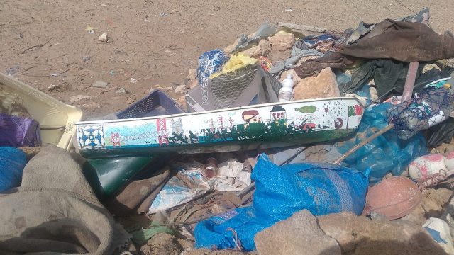 The Legendary landed on a sandy beach in Morocco, just south of Zaouiet Bouzarktoune. (c): Educational Passages[/caption]
[caption id="attachment_36321" align="alignnone" width="360"]
The Legendary landed on a sandy beach in Morocco, just south of Zaouiet Bouzarktoune. (c): Educational Passages[/caption]
[caption id="attachment_36321" align="alignnone" width="360"]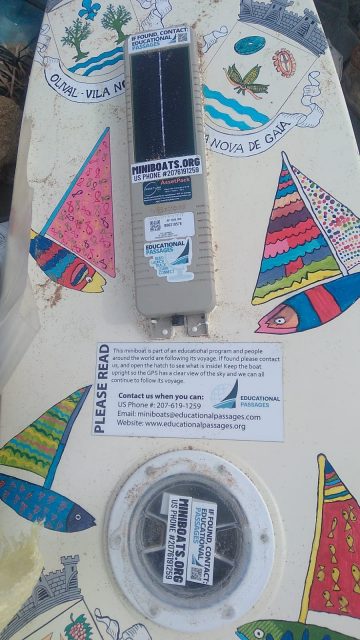 The Legendary (c): Educational Passages[/caption]
Read More
The Legendary (c): Educational Passages[/caption]
Read More